
Eastbank Esplanade
Encyclopedia

Willamette River
The Willamette River is a major tributary of the Columbia River, accounting for 12 to 15 percent of the Columbia's flow. The Willamette's main stem is long, lying entirely in northwestern Oregon in the United States...
in Portland
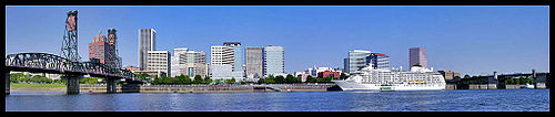
Portland, Oregon
Portland is a city located in the Pacific Northwest, near the confluence of the Willamette and Columbia rivers in the U.S. state of Oregon. As of the 2010 Census, it had a population of 583,776, making it the 29th most populous city in the United States...
, Oregon
Oregon
Oregon is a state in the Pacific Northwest region of the United States. It is located on the Pacific coast, with Washington to the north, California to the south, Nevada on the southeast and Idaho to the east. The Columbia and Snake rivers delineate much of Oregon's northern and eastern...
, United States
United States
The United States of America is a federal constitutional republic comprising fifty states and a federal district...
. Running through the Kerns
Kerns, Portland, Oregon
Kerns is a neighborhood in the inner Northeast and Southeast sections of Portland, Oregon. It borders the Lloyd District and Sullivan's Gulch on the north, Laurelhurst on the east, Buckman and Sunnyside on the south, and Old Town Chinatown on the west.Parks in Kerns include Everett Community...
, Buckman
Buckman, Portland, Oregon
Buckman is a neighborhood in the Southeast section of Portland, Oregon. The neighborhood is bounded by the Willamette River on the west, E Burnside St. on the north , SE 28th Ave. on the east, and SE Hawthorne Blvd...
, and Hosford-Abernethy
Hosford-Abernethy, Portland, Oregon
Hosford-Abernethy is a neighborhood in the inner Southeast section of Portland, Oregon. It borders Buckman and Sunnyside on the north, Richmond on the east, Brooklyn and Creston-Kenilworth on the south, and Downtown Portland and South Portland on the west.Hosford-Abernethy was named in the 1970s...
neighborhoods, it was conceived as an urban renewal
Urban renewal
Urban renewal is a program of land redevelopment in areas of moderate to high density urban land use. Renewal has had both successes and failures. Its modern incarnation began in the late 19th century in developed nations and experienced an intense phase in the late 1940s – under the rubric of...
project to rebuild the Interstate 5
Interstate 5
Interstate 5 is the main Interstate Highway on the West Coast of the United States, running largely parallel to the Pacific Ocean coastline from Canada to Mexico . It serves some of the largest cities on the U.S...
bicycle bypass washed out by the Willamette Valley Flood of 1996
Willamette Valley Flood of 1996
The Willamette Valley Flood of 1996 was part of a larger series of floods in the Pacific Northwest of the United States which took place between late January and mid-February, 1996. It was Oregon's largest flood event in terms of fatalities and monetary damage during the 1990s...
. It was renamed for former Portland mayor Vera Katz
Vera Katz
Vera Katz is a Democratic politician in the state of Oregon. She was the first woman to serve as Speaker of the Oregon House of Representatives and was the 45th mayor of Portland, Oregon's most populous city. Growing up in New York City, she moved to Portland in 1962 and was elected to the Oregon...
in November 2004 and features a statue of her near the Hawthorne Bridge
Hawthorne Bridge
The Hawthorne Bridge is a truss bridge with a vertical lift that spans the Willamette River in Portland, Oregon, joining Hawthorne Boulevard and Madison Street. It is the oldest vertical-lift bridge in operation in the United States and the oldest highway bridge in Portland...
.
The project, designed by landscape architects Mayer/Reed, cost $30 million, of which $10 million built a lower deck on the Steel Bridge
Steel Bridge
The Steel Bridge is a through truss, double lift bridge across the Willamette River in Portland, Oregon, United States. Its lower deck carries railroad and bicycle/pedestrian traffic, while the upper deck carries road traffic and light rail , making the bridge one of the most multimodal in the world...
. Construction began in October 1998, and the walkway was dedicated in May 2001.
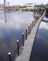
The esplanade extends 1.5 miles (2.4 km) from the Steel Bridge (45.526871°N 122.670403°W) to the Hawthorne Bridge
Hawthorne Bridge
The Hawthorne Bridge is a truss bridge with a vertical lift that spans the Willamette River in Portland, Oregon, joining Hawthorne Boulevard and Madison Street. It is the oldest vertical-lift bridge in operation in the United States and the oldest highway bridge in Portland...
(45.512804°N 122.668059°W). The south end connects to the Springwater Corridor
Springwater Corridor
The Springwater Corridor Trail is a bicycle and pedestrian rail trail in the Portland metropolitan area in Oregon, United States. It follows a former railway line of the same name in its route from Boring, through Gresham, to Portland, where it ends near the Eastbank Esplanade. A large segment...
, a rail trail
Rail trail
A rail trail is the conversion of a disused railway easement into a multi-use path, typically for walking, cycling and sometimes horse riding. The characteristics of former tracks—flat, long, frequently running through historical areas—are appealing for various development. The term sometimes also...
that runs south to Sellwood
Sellwood, Portland, Oregon
Sellwood-Moreland is a neighborhood on a bluff overlooking the Willamette River in Southeast Portland, Oregon, bordering Westmoreland to the north, Eastmoreland to the east, and the city of Milwaukie to the south...
, then east to Gresham
Gresham, Oregon
- Demographics :As of the census of 2000, there were 90,205 people, 33,327 households, and 22,695 families residing in the city. The population density was 4,071.6 people per square mile . There were 35,309 housing units at an average density of 1,593.8 per square mile...
, then south to Boring
Boring, Oregon
Boring is an unincorporated community located in Clackamas County, Oregon, United States, on Oregon Route 212. It is approximately eight miles south of Gresham and about the same distance from Clackamas, both suburbs of Portland. The town is roughly twenty-two miles southeast from downtown...
. The esplanade
Esplanade
An esplanade is a long, open, level area, usually next to a river or large body of water, where people may walk. The original meaning of esplanade was a large, open, level area outside fortress or city walls to provide clear fields of fire for the fortress' guns...
includes a 1200 feet (365.8 m) floating walkway, the longest of its kind in the United States
United States
The United States of America is a federal constitutional republic comprising fifty states and a federal district...
. Connected to this is a 120 feet (36.6 m) public dock. Thirteen markers along the esplanade correspond to the eastside street grid.
External links
- Portland Development Commission Eastbank Esplanade site
- American Society of Landscape Architects, 2004 Design Award of Merit