
2009 Red River flood
Encyclopedia
The 2009 Red River flood along the Red River of the North
in North Dakota
and Minnesota
in the United States and Manitoba
in Canada brought record flood levels to the Fargo-Moorhead
area. The flood was a result of saturated and frozen ground, Spring snowmelt exacerbated by additional rain and snow storms, and virtually flat terrain. Communities along the Red River prepared for more than a week as the U.S. National Weather Service
continuously updated the predictions for the city of Fargo, North Dakota
with an increasingly higher projected river crest. Originally predicted to reach a level of near 43 feet (13.1 m) at Fargo by March 29, the river in fact crested at 40.84 feet (12.4 m) at 12:15 a.m. March 28, and started a slow decline. The river continued to rise to the north as the crest moved downstream.
in Manitoba
, Canada. Unlike the vast majority of rivers in the United States, it flows northward, which means melting snow and river ice, as well as runoff from its tributaries, often create ice dam
s, which cause the river to overflow. The valley is essentially flat, leading to overland flooding, with no high ground on which to take refuge.
A low-pressure area caused the rain storm on March 22 and by March 25 a total of 15 to 25 cm (6 to 10 inches) fell in the Winnipeg area, and 20 to 30 cm (8 to 12 inches) in southern Manitoba. In northeastern North Dakota and northwestern Minnesota, around 8 inches of snow accumulated from the same storm.
 Warnings for the 2009 flood occurred as early as March 9 when the National Weather Service
warned that the Fargo-Moorhead
area could see a significant flood of between 35 feet (10.7 m) and 36 feet (11 m). As preparations began for the flooding on March 16, North Dakota Governor John Hoeven
declared a statewide disaster in anticipation of flooding across the state. On March 19, the National Weather Service raised the predicted flood level in the Fargo area to between 37 feet (11.3 m) and 40 feet (12.2 m). The city began filling sandbags on March 20. In anticipation of a rain and snow storm, the predicted crest level was raised on March 22 to a range from 39 feet (11.9 m) to 41 feet (12.5 m).
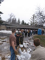
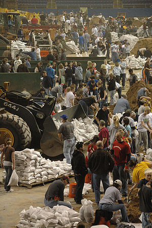
Volunteers continued preparing sandbags, with 560,000 bags filled by late March 22, out of an expected 1.5 million to 2 million needed. By March 24, residents in Fargo-Moorhead had filled over 1 million sandbags and were attempting to fill a total of 2 million by the 26th. A levee in Georgetown, Minnesota
was raised another two feet, and emergency dikes were being built in Fargo
, Moorhead
, Harwood
, Grafton
and Richland County
. The predicted flood crest was raised again on March 26, changed to between 41 feet (12.5 m) and 42 feet (12.8 m) by March 28, with a possibility of 43 feet (13.1 m).
 In addition to the sandbags, the construction of the dikes protecting the city required large amounts of clay. Clay had been brought from several places in and around the city, including the soccer field at Centennial Elementary School and around Discovery Middle School.
-Breckenridge
area saw a predicted level of at least 16 feet (4.9 m). By March 24, the National Weather Service predicted the crest in Wahpeton and Breckenridge not to top 18 feet (5.5 m), below the cities' levees.
area, flood predictions released February 27 predicted a possibility of a flood crest between 44 feet (13.4 m) and 46 feet (14 m). The snowstorm that struck March 9–10 raised the predicted levels between 47 feet (14.3 m) and 50 feet (15.2 m) prompting the city to declare a state of emergency. On March 22 the predicted crest level was changed to 52 feet (15.8 m).
was not initially opened, due to the Red River being full of ice, which can lead to damage of the floodway and the flooding of Selkirk
. The Red River Floodway was opened in early April once the ice jams cleared. Several towns and R.M.s declared a state of emergency due to the ice jams built up in places along the Red. Flooding in Manitoba was not expected until the second week of April. The CPR Line from Winnipeg to Emerson closed.
The floodway was opened around 1 p.m. on April 8 due to a crest expected to hit the city of Winnipeg. Highway 75, a major artery between Winnipeg and the U.S. border, was closed between April 7 and May 13. This closure cost Manitoba trucking companies thousands of dollars in additional travel costs and severely hurt the economy of the town of Morris
.
An eight-year-old boy fell into the river on Thursday,
April 9 on the Westroc Hutterite Colony which is near Portage la Prairie. Samuel Gross came out of his 13-day coma after being under icy cold water for 20 minutes. The team under Murray Kesselman, director of the Health Sciences Centre pediatric intensive care unit, worked on Gross's heart for two hours before it started to beat on its own and he began to recover. Walter Imbeck, 68 years old, went missing since April 11 when friends and neighbours thought he was trying to clear a broken drain behind his home, which was along the riverbank. As of April 13, several communities north of Winnipeg had to be evacuated due to flash flooding and ice jams on the Red River. It was predicted to be the third worst flood, next to the floods of 1950 and 1997. A 79-year-old woman, Mary, died, and her 82-year-old husband, Glen Silverthorn, went missing Easter Sunday after their car was swept into the Woody River. A search commenced, and his body was found on May 19.
Prime Minister Stephen Harper toured the flooded area on April 14, 2009. Damages were expected to be in the millions. On April 15, 2009 Winnipeg declared a local state of emergency due to several of the rivers, which flow into the Red River, swelling extremely fast. On April 16, 2009 the Red River crested in Winnipeg at 22.6 feet (6.9 m) before retreating. If Winnipeg had not had any flood protection, the city would have been 9.23 metres (30.3 ft) submerged. The crest from North Dakota was expected to hit either April 19 or April 20 and forced 28,000 evacuations. 777 km² (300 sq mi) are under water at some places 19 kilometres (11.8 mi) wide as reported April 18. 740 people were evacuated from the Peguis First Nation
, which is located north of Winnipeg. Peguis Chief Glenn Hudson said "either build a dike, or a floodway around ... I think we have to do something," Steve Ashton, minister responsible for the emergency measures organization, said that Disaster Financial Assistance was doubled to $200,000. The Federal Government was expected to assist with up to 90% of the relief, and 100% on reserves.
The province assessed whether homeowner buyouts would be voluntary or mandatory. "We'd look at voluntary buyouts as the first option, but the municipalities have raised this ...they're the ones that have to send in first responders and rescue crews," said Steve Ashton, the province's Emergency Measures Minister. Mayor Sam Katz reported an estimated $5 million for sandbag flood prevention costs, which included making and setting into place the sandbags and patrolling them, and then removing them after the river went back down. Some roads and bridges were also damaged as a result of flooding. Peguis Chief Glen Hudson estimated the evacuation and dike construction for the first nation reserve was pegged at approximately $3 million. A water quality warning went into effect, and residents who remained were advised to boil water before use. Free water analysis was provided by the Manitoba government until July. On April 20, the total amount of land submerged was upgraded to 1680 km² (648.7 sq mi), and the river crest was still 60 kilometres (37.3 mi) south of Winnipeg.
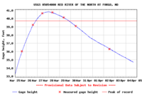
 At 7:15 p.m. CDT on March 26, 2009, the river exceeded the 1997 crest of 39.57 feet (12.1 m) at Fargo, which was the previous second-highest crest. The projected crest was 24 feet (7.3 m) above flood stage and higher than the record-setting floods in 1997 and 1897
.
At 2:30 a.m. CDT on March 27, the National Weather Service offices in Grand Forks issued a Flash Flood Warning
for extreme east-central Cass County due to a levee breach in Fargo on Lindenwood Drive. With the river more than 6 meters (20 ft) above flood stage, there appeared to be a growing sense in Fargo that despite best efforts, it might not be possible to build dikes high enough to hold back the river. The Manitoba government upgraded the 2009 flood as the second highest to hit southern Manitoba over the last 150 years, just 60 centimetres (23.6 in) lower than the 1997 Flood of the Century. The highest level in 2009 was 6.9 metres (22.6 ft), and in 1997 it was 7.5 metres (24.6 ft). However, without flood control measures such as the Red River floodway, Portage Diversion and Shellmouth dam, the peak would have been 10.2 metres (33.5 ft), which is higher than the 1950 peak of 9.3 metres (30.5 ft) in Winnipeg. The Red River showed signs of receding April 23, however the Souris river was expected to crest towards the end of the month of April.
formed north of Winnipeg, causing the municipalities of St. Andrews
, St. Clements
, East St. Paul and West St. Paul
to declare a state of emergency
. Flooding from the ice jam necessitated the evacuation of about thirty homes. While the jam was broken, it reformed near Lower Fort Garry
, causing the water to rise 4.5 meters (14.7 ft) in 2 hours. On March 31, a state of emergency was declared for the city of Selkirk due to concerns over ice jams.
Dominion City
was the first town in Manitoba to declare a state of emergency on Monday, March 23. Government officials handed out evacuation alerts to 850 residents. Forty homes north of Winnipeg were evacuated, while dozens of homes were flooded due to ice jams. On Thursday, March 26, some 95 elderly and special needs people were evacuated from the Roseau River Anishinabe First Nation
. An engineering firm detonated charges downstream of Bismarck, North Dakota
to clear an ice jam which was causing flooding in the city causing an evacuation of 1,700 persons. There were three million sandbags, rolls of poly film Hesco bastion
flood walls
, and water pumps sent out by the U.S. Army Corps of Engineers to North Dakota. Both North Dakota and Manitoba used backhoes from the river bank and from bridges, but these machines had a 20 feet (6.1 m) reach for a 0.25 mile (0.402335 km) river. A Chinook
helicopter was deployed with a 1400 kilograms (3,086.5 lb) concrete weight to try to break up an ice jam, but only small pieces of ice broke away. The North Dakota National Guard used 160 pounds (72.6 kg) of C-4 plastic explosives on the 3 foot (0.9144 m) ice placed into 80 holes. The ice was then coated with road salt to hasten melting. The Army Corps of Engineers also resorted to using sand, salt, chemicals and drilling to alleviate the ice jams. The Manitoba government chose not to use dynamite, as explosives work well on large ice sheets but not as well on broken and fused ice. To set the dynamite, holes need to be drilled in the ice, which would require someone to hang suspended from a helicopter. The end result of dynamite forms a hole centrally in the ice without loosening up the ice jam blockage to allow water to flow past. Manitoba purchased five new certified emergency response trailers (CERTs), which are 15 metres (49.2 ft) tubes with 60 compartments which can be filled with water and used to build dikes. These tubes take 10 minutes to fill up and provide the same protection as 500 sandbags. Volunteers created over 600,000 sandbags to shore up defences against the Red River and unpredictable flows caused by ice jams. Dikes were placed along the shoreline within the city to protect neighbourhoods against ice jam flooding. Over 1,600 volunteers came out since April 1 to assist with creating sandbag dikes which were built 20.5 feet (6.2 m) high. Frozen culverts and sewer inlets were cleared to allow runoff from meltwaters and floodwaters.
Amphibex excavator icebreakers were at work breaking up ice flows on the Red River. Ice breakers and backhoes were to be strategically placed along the Red River Floodway, which might have needed to be opened before the ice was fully melted. Officials examined past ice jams and provided contingency plans if the Floodway jammed upstream of bridges or on tight corners. On Easter Sunday, April 12, Winnipeg
was clear of ice blocks and ice jams. Sightseers traveling by car, boat, kayak and anyone ignoring road closures were being ticketed by the Royal Canadian Mounted Police
as they were hampering ice clearing operations. Residents of the rural municiplaites
of St. Andrews
and St. Clements
were given evacuation alerts on Good Friday. Some chose to remain behind, and rescue efforts commenced for them over the Easter week-end. Homes were smashed in and knocked off their basements and footings by 7 feet (2.1 m) sheets of ice.
reeves have approached the Canadian government with a CA$288,000 plan which would use the province of Manitoba's existing Amphibex ice-breaking excavators to dredge the Red River between Selkirk
and the mouth of Lake Winnipeg
.
Red River of the North
The Red River is a North American river. Originating at the confluence of the Bois de Sioux and Otter Tail rivers in the United States, it flows northward through the Red River Valley and forms the border between the U.S. states of Minnesota and North Dakota before continuing into Manitoba, Canada...
in North Dakota
North Dakota
North Dakota is a state located in the Midwestern region of the United States of America, along the Canadian border. The state is bordered by Canada to the north, Minnesota to the east, South Dakota to the south and Montana to the west. North Dakota is the 19th-largest state by area in the U.S....
and Minnesota
Minnesota
Minnesota is a U.S. state located in the Midwestern United States. The twelfth largest state of the U.S., it is the twenty-first most populous, with 5.3 million residents. Minnesota was carved out of the eastern half of the Minnesota Territory and admitted to the Union as the thirty-second state...
in the United States and Manitoba
Manitoba
Manitoba is a Canadian prairie province with an area of . The province has over 110,000 lakes and has a largely continental climate because of its flat topography. Agriculture, mostly concentrated in the fertile southern and western parts of the province, is vital to the province's economy; other...
in Canada brought record flood levels to the Fargo-Moorhead
Fargo-Moorhead
Fargo-Moorhead is a common name given to the metropolitan area comprising Fargo, North Dakota, Moorhead, Minnesota, and the surrounding communities. These two cities lie on the North Dakota-Minnesota border, on opposite banks of the Red River of the North...
area. The flood was a result of saturated and frozen ground, Spring snowmelt exacerbated by additional rain and snow storms, and virtually flat terrain. Communities along the Red River prepared for more than a week as the U.S. National Weather Service
National Weather Service
The National Weather Service , once known as the Weather Bureau, is one of the six scientific agencies that make up the National Oceanic and Atmospheric Administration of the United States government...
continuously updated the predictions for the city of Fargo, North Dakota
Fargo, North Dakota
Fargo is the largest city in the U.S. state of North Dakota and the county seat of Cass County. In 2010, its population was 105,549, and it had an estimated metropolitan population of 208,777...
with an increasingly higher projected river crest. Originally predicted to reach a level of near 43 feet (13.1 m) at Fargo by March 29, the river in fact crested at 40.84 feet (12.4 m) at 12:15 a.m. March 28, and started a slow decline. The river continued to rise to the north as the crest moved downstream.
Geology
The Red River flows from the United States into Lake WinnipegLake Winnipeg
Lake Winnipeg is a large, lake in central North America, in the province of Manitoba, Canada, with its southern tip about north of the city of Winnipeg...
in Manitoba
Manitoba
Manitoba is a Canadian prairie province with an area of . The province has over 110,000 lakes and has a largely continental climate because of its flat topography. Agriculture, mostly concentrated in the fertile southern and western parts of the province, is vital to the province's economy; other...
, Canada. Unlike the vast majority of rivers in the United States, it flows northward, which means melting snow and river ice, as well as runoff from its tributaries, often create ice dam
Ice dam
An ice dam occurs when water builds up behind a blockage of ice. Ice dams can occur in various ways.-Caused by a glacier:Sometimes a glacier flows down a valley to a confluence where the other branch carries an unfrozen river...
s, which cause the river to overflow. The valley is essentially flat, leading to overland flooding, with no high ground on which to take refuge.
Climate
Ground which was already saturated when it froze at the onset of winter, melting snow which could not be absorbed by the frozen ground, and additional precipitation from high winter snow fall, a rain storm on March 22 and a later snowstorm, high temperature snow melt rate, are reasons for the serious flooding.A low-pressure area caused the rain storm on March 22 and by March 25 a total of 15 to 25 cm (6 to 10 inches) fell in the Winnipeg area, and 20 to 30 cm (8 to 12 inches) in southern Manitoba. In northeastern North Dakota and northwestern Minnesota, around 8 inches of snow accumulated from the same storm.
Fargo-Moorhead
National Weather Service
The National Weather Service , once known as the Weather Bureau, is one of the six scientific agencies that make up the National Oceanic and Atmospheric Administration of the United States government...
warned that the Fargo-Moorhead
Fargo-Moorhead
Fargo-Moorhead is a common name given to the metropolitan area comprising Fargo, North Dakota, Moorhead, Minnesota, and the surrounding communities. These two cities lie on the North Dakota-Minnesota border, on opposite banks of the Red River of the North...
area could see a significant flood of between 35 feet (10.7 m) and 36 feet (11 m). As preparations began for the flooding on March 16, North Dakota Governor John Hoeven
John Hoeven
John Henry Hoeven III is the junior United States Senator from North Dakota. He is a member of the North Dakota Republican Party. He is expected to become the state's senior senator when Kent Conrad retires from the Senate in January 2013.Hoeven served as the 31st Governor of North Dakota,...
declared a statewide disaster in anticipation of flooding across the state. On March 19, the National Weather Service raised the predicted flood level in the Fargo area to between 37 feet (11.3 m) and 40 feet (12.2 m). The city began filling sandbags on March 20. In anticipation of a rain and snow storm, the predicted crest level was raised on March 22 to a range from 39 feet (11.9 m) to 41 feet (12.5 m).
Volunteers continued preparing sandbags, with 560,000 bags filled by late March 22, out of an expected 1.5 million to 2 million needed. By March 24, residents in Fargo-Moorhead had filled over 1 million sandbags and were attempting to fill a total of 2 million by the 26th. A levee in Georgetown, Minnesota
Georgetown, Minnesota
Georgetown is a city in Clay County, Minnesota, United States, along the Buffalo River near its confluence with the Red River of the North. The population was 129 at the 2010 census.-Geography:...
was raised another two feet, and emergency dikes were being built in Fargo
Fargo, North Dakota
Fargo is the largest city in the U.S. state of North Dakota and the county seat of Cass County. In 2010, its population was 105,549, and it had an estimated metropolitan population of 208,777...
, Moorhead
Moorhead, Minnesota
Moorhead is a city in Clay County, Minnesota, United States, and the largest city in northwest Minnesota. The population was 38,065 at the 2010 Census. It is the county seat of Clay County....
, Harwood
Harwood, North Dakota
As of the census of 2000, there were 607 people, 192 households, and 174 families residing in the city. The population density was 517.9 people per square mile . There were 201 housing units at an average density of 171.5 per square mile . The racial makeup of the city was 99.01% White, 0.33% from...
, Grafton
Grafton, North Dakota
-Education:The city of Grafton is served by the Grafton Public Schools system. The system includes Century Elementary School , Central Middle School , and Grafton High School .-Library:...
and Richland County
Richland County, North Dakota
-History:Richland County wa formed in 1873. It was named for Morgan T. Rich, an early settler in the area.-Demographics:As of the census of 2000, there were 17,998 people, 6,885 households, and 4,427 families residing in the county. The population density was 12 people per square mile . There...
. The predicted flood crest was raised again on March 26, changed to between 41 feet (12.5 m) and 42 feet (12.8 m) by March 28, with a possibility of 43 feet (13.1 m).
Wahpeton-Breckenridge
Elsewhere along the river, early predictions for the WahpetonWahpeton, North Dakota
The first European explorer in the area was Jonathan Carver in 1767. He explored and mapped the Northwest at the request of Major Robert Rogers, commander of Fort Michilimackinac, the British fort at Mackinaw City, Michigan, which protected the passage between Lake Michigan and Lake Huron...
-Breckenridge
Breckenridge, Minnesota
As of the census of 2000, there were 3,559 people, 1,438 households, and 911 families residing in the city. The population density was 1,516.4 people per square mile . There were 1,582 housing units at an average density of 674.0 per square mile...
area saw a predicted level of at least 16 feet (4.9 m). By March 24, the National Weather Service predicted the crest in Wahpeton and Breckenridge not to top 18 feet (5.5 m), below the cities' levees.
Grand Forks
In the Grand Forks, North DakotaGrand Forks, North Dakota
Grand Forks is the third-largest city in the U.S. state of North Dakota and the county seat of Grand Forks County. According to the 2010 census, the city's population was 52,838, while that of the city and surrounding metropolitan area was 98,461...
area, flood predictions released February 27 predicted a possibility of a flood crest between 44 feet (13.4 m) and 46 feet (14 m). The snowstorm that struck March 9–10 raised the predicted levels between 47 feet (14.3 m) and 50 feet (15.2 m) prompting the city to declare a state of emergency. On March 22 the predicted crest level was changed to 52 feet (15.8 m).
Manitoba
In Manitoba, the 2009 flood was the second worst on record since 1826. The Red River FloodwayRed River Floodway
The Red River Floodway is an artificial flood control waterway in Western Canada, first used in 1969. It is a long channel which, during flood periods, takes part of the Red River's flow around the city of Winnipeg, Manitoba to the east and discharges it back into the Red River below the dam at...
was not initially opened, due to the Red River being full of ice, which can lead to damage of the floodway and the flooding of Selkirk
Selkirk, Manitoba
Selkirk is a city in the western Canadian province of Manitoba, located about 22 km northeast of the provincial capital Winnipeg on the Red River, near . As of the 2006 census, Selkirk had a population of 9,515....
. The Red River Floodway was opened in early April once the ice jams cleared. Several towns and R.M.s declared a state of emergency due to the ice jams built up in places along the Red. Flooding in Manitoba was not expected until the second week of April. The CPR Line from Winnipeg to Emerson closed.
The floodway was opened around 1 p.m. on April 8 due to a crest expected to hit the city of Winnipeg. Highway 75, a major artery between Winnipeg and the U.S. border, was closed between April 7 and May 13. This closure cost Manitoba trucking companies thousands of dollars in additional travel costs and severely hurt the economy of the town of Morris
Morris, Manitoba
Morris is a small town of about 1700 people in the Pembina Valley region of Manitoba, Canada, located about 50 km south of Winnipeg and 50 km north of Emerson. Morris is host to the annual Manitoba Stampede & Exhibition. Highway 75 which turns in to Interstate 29 is the major highway...
.
An eight-year-old boy fell into the river on Thursday,
April 9 on the Westroc Hutterite Colony which is near Portage la Prairie. Samuel Gross came out of his 13-day coma after being under icy cold water for 20 minutes. The team under Murray Kesselman, director of the Health Sciences Centre pediatric intensive care unit, worked on Gross's heart for two hours before it started to beat on its own and he began to recover. Walter Imbeck, 68 years old, went missing since April 11 when friends and neighbours thought he was trying to clear a broken drain behind his home, which was along the riverbank. As of April 13, several communities north of Winnipeg had to be evacuated due to flash flooding and ice jams on the Red River. It was predicted to be the third worst flood, next to the floods of 1950 and 1997. A 79-year-old woman, Mary, died, and her 82-year-old husband, Glen Silverthorn, went missing Easter Sunday after their car was swept into the Woody River. A search commenced, and his body was found on May 19.
Prime Minister Stephen Harper toured the flooded area on April 14, 2009. Damages were expected to be in the millions. On April 15, 2009 Winnipeg declared a local state of emergency due to several of the rivers, which flow into the Red River, swelling extremely fast. On April 16, 2009 the Red River crested in Winnipeg at 22.6 feet (6.9 m) before retreating. If Winnipeg had not had any flood protection, the city would have been 9.23 metres (30.3 ft) submerged. The crest from North Dakota was expected to hit either April 19 or April 20 and forced 28,000 evacuations. 777 km² (300 sq mi) are under water at some places 19 kilometres (11.8 mi) wide as reported April 18. 740 people were evacuated from the Peguis First Nation
Peguis First Nation
Peguis First Nation is the largest First Nations community in Manitoba, Canada,with a population of approximately 7,338 people. It is located approximately 145 kilometres north of Winnipeg. The citizens of Peguis are of Ojibway and Cree descent.-History:...
, which is located north of Winnipeg. Peguis Chief Glenn Hudson said "either build a dike, or a floodway around ... I think we have to do something," Steve Ashton, minister responsible for the emergency measures organization, said that Disaster Financial Assistance was doubled to $200,000. The Federal Government was expected to assist with up to 90% of the relief, and 100% on reserves.
The province assessed whether homeowner buyouts would be voluntary or mandatory. "We'd look at voluntary buyouts as the first option, but the municipalities have raised this ...they're the ones that have to send in first responders and rescue crews," said Steve Ashton, the province's Emergency Measures Minister. Mayor Sam Katz reported an estimated $5 million for sandbag flood prevention costs, which included making and setting into place the sandbags and patrolling them, and then removing them after the river went back down. Some roads and bridges were also damaged as a result of flooding. Peguis Chief Glen Hudson estimated the evacuation and dike construction for the first nation reserve was pegged at approximately $3 million. A water quality warning went into effect, and residents who remained were advised to boil water before use. Free water analysis was provided by the Manitoba government until July. On April 20, the total amount of land submerged was upgraded to 1680 km² (648.7 sq mi), and the river crest was still 60 kilometres (37.3 mi) south of Winnipeg.
Flooding
1897 Red River Flood
The 1897 Red River Flood took place in April 1897, along the Red River resulting in significant damage to the city of Fargo, North Dakota. The conditions which led to the flood of 1897 were similar to the conditions behind the 2009 flood, however the 1897 flood was different in terms of the human...
.
At 2:30 a.m. CDT on March 27, the National Weather Service offices in Grand Forks issued a Flash Flood Warning
Flash Flood Warning
A Flash Flood Warning is issued when a flash flood is imminent or occurring in the warned area. A flash flood is a sudden, violent flood after a heavy rain...
for extreme east-central Cass County due to a levee breach in Fargo on Lindenwood Drive. With the river more than 6 meters (20 ft) above flood stage, there appeared to be a growing sense in Fargo that despite best efforts, it might not be possible to build dikes high enough to hold back the river. The Manitoba government upgraded the 2009 flood as the second highest to hit southern Manitoba over the last 150 years, just 60 centimetres (23.6 in) lower than the 1997 Flood of the Century. The highest level in 2009 was 6.9 metres (22.6 ft), and in 1997 it was 7.5 metres (24.6 ft). However, without flood control measures such as the Red River floodway, Portage Diversion and Shellmouth dam, the peak would have been 10.2 metres (33.5 ft), which is higher than the 1950 peak of 9.3 metres (30.5 ft) in Winnipeg. The Red River showed signs of receding April 23, however the Souris river was expected to crest towards the end of the month of April.
Ice jams
On March 25, an ice jamIce dam
An ice dam occurs when water builds up behind a blockage of ice. Ice dams can occur in various ways.-Caused by a glacier:Sometimes a glacier flows down a valley to a confluence where the other branch carries an unfrozen river...
formed north of Winnipeg, causing the municipalities of St. Andrews
St. Andrews, Manitoba
St. Andrews is a rural municipality in Manitoba, Canada. It is located to the north-east of Winnipeg and the Red River demarcates the eastern boundary of the municipality. St. Andrews contains the communities of Clandeboye, Petersfield, and Lockport . It is part of Manitoba census division 13....
, St. Clements
St. Clements, Manitoba
St. Clements is a rural municipality in Manitoba, Canada. It is located to the north-east of Winnipeg, stretching from East St. Paul and Birds Hill Provincial Park in the south to Lake Winnipeg and Grand Beach Provincial Park to the north. The Red River demarcates the western boundary of the...
, East St. Paul and West St. Paul
West St. Paul, Manitoba
West St. Paul is a rural municipality in Manitoba, Canada. It lies adjacent to the north side of Winnipeg, and directly west of the Red River. It is part of the Winnipeg Capital Region, and had a population of 4,357 as of the 2006 census...
to declare a state of emergency
State of emergency
A state of emergency is a governmental declaration that may suspend some normal functions of the executive, legislative and judicial powers, alert citizens to change their normal behaviours, or order government agencies to implement emergency preparedness plans. It can also be used as a rationale...
. Flooding from the ice jam necessitated the evacuation of about thirty homes. While the jam was broken, it reformed near Lower Fort Garry
Lower Fort Garry
Lower Fort Garry was built in 1830 by the Hudson's Bay Company on the western bank of the Red River, north of the original Fort Garry, which is now in Winnipeg, Manitoba, Canada. Treaty 1 was signed there....
, causing the water to rise 4.5 meters (14.7 ft) in 2 hours. On March 31, a state of emergency was declared for the city of Selkirk due to concerns over ice jams.
Dominion City
Dominion City, Manitoba
Dominion City is a community in the Rural Municipality of Franklin in the Canadian province of Manitoba. It is located in south central Manitoba about 20 kilometres from the Canada-U.S. border....
was the first town in Manitoba to declare a state of emergency on Monday, March 23. Government officials handed out evacuation alerts to 850 residents. Forty homes north of Winnipeg were evacuated, while dozens of homes were flooded due to ice jams. On Thursday, March 26, some 95 elderly and special needs people were evacuated from the Roseau River Anishinabe First Nation
Roseau River Anishinabe First Nation
Roseau River Anishinabe First Nation is a First Nation in southern Manitoba, Canada. It has a registered population of 2,152 individuals. The First Nation has three reserves, of which the Roseau River No. 2 has an area of 22.242 square kilometres , while the Roseau Rapids No. 2A is considerably...
. An engineering firm detonated charges downstream of Bismarck, North Dakota
Bismarck, North Dakota
Bismarck is the capital of the U.S. state of North Dakota and the county seat of Burleigh County. It is the second most populous city in North Dakota after Fargo. The city's population was 61,272 at the 2010 census, while its metropolitan population was 108,779...
to clear an ice jam which was causing flooding in the city causing an evacuation of 1,700 persons. There were three million sandbags, rolls of poly film Hesco bastion
Hesco bastion
The HESCO bastion is both a modern gabion used for flood control and military fortification and the name of the British company that developed it in the late 1980s. It is made of a collapsible wire mesh container and heavy duty fabric liner, and used as a temporary to semi-permanent dike or barrier...
flood walls
Defensive wall
A defensive wall is a fortification used to protect a city or settlement from potential aggressors. In ancient to modern times, they were used to enclose settlements...
, and water pumps sent out by the U.S. Army Corps of Engineers to North Dakota. Both North Dakota and Manitoba used backhoes from the river bank and from bridges, but these machines had a 20 feet (6.1 m) reach for a 0.25 mile (0.402335 km) river. A Chinook
CH-47 Chinook
The Boeing CH-47 Chinook is an American twin-engine, tandem rotor heavy-lift helicopter. Its top speed of 170 knots is faster than contemporary utility and attack helicopters of the 1960s...
helicopter was deployed with a 1400 kilograms (3,086.5 lb) concrete weight to try to break up an ice jam, but only small pieces of ice broke away. The North Dakota National Guard used 160 pounds (72.6 kg) of C-4 plastic explosives on the 3 foot (0.9144 m) ice placed into 80 holes. The ice was then coated with road salt to hasten melting. The Army Corps of Engineers also resorted to using sand, salt, chemicals and drilling to alleviate the ice jams. The Manitoba government chose not to use dynamite, as explosives work well on large ice sheets but not as well on broken and fused ice. To set the dynamite, holes need to be drilled in the ice, which would require someone to hang suspended from a helicopter. The end result of dynamite forms a hole centrally in the ice without loosening up the ice jam blockage to allow water to flow past. Manitoba purchased five new certified emergency response trailers (CERTs), which are 15 metres (49.2 ft) tubes with 60 compartments which can be filled with water and used to build dikes. These tubes take 10 minutes to fill up and provide the same protection as 500 sandbags. Volunteers created over 600,000 sandbags to shore up defences against the Red River and unpredictable flows caused by ice jams. Dikes were placed along the shoreline within the city to protect neighbourhoods against ice jam flooding. Over 1,600 volunteers came out since April 1 to assist with creating sandbag dikes which were built 20.5 feet (6.2 m) high. Frozen culverts and sewer inlets were cleared to allow runoff from meltwaters and floodwaters.
Amphibex excavator icebreakers were at work breaking up ice flows on the Red River. Ice breakers and backhoes were to be strategically placed along the Red River Floodway, which might have needed to be opened before the ice was fully melted. Officials examined past ice jams and provided contingency plans if the Floodway jammed upstream of bridges or on tight corners. On Easter Sunday, April 12, Winnipeg
Winnipeg
Winnipeg is the capital and largest city of Manitoba, Canada, and is the primary municipality of the Winnipeg Capital Region, with more than half of Manitoba's population. It is located near the longitudinal centre of North America, at the confluence of the Red and Assiniboine Rivers .The name...
was clear of ice blocks and ice jams. Sightseers traveling by car, boat, kayak and anyone ignoring road closures were being ticketed by the Royal Canadian Mounted Police
Royal Canadian Mounted Police
The Royal Canadian Mounted Police , literally ‘Royal Gendarmerie of Canada’; colloquially known as The Mounties, and internally as ‘The Force’) is the national police force of Canada, and one of the most recognized of its kind in the world. It is unique in the world as a national, federal,...
as they were hampering ice clearing operations. Residents of the rural municiplaites
Rural municipality
A rural municipality, often abbreviated RM, is a form of municipality in the Canadian provinces of Manitoba and Saskatchewan, perhaps best comparable to counties or townships in the western United States...
of St. Andrews
St. Andrews, Manitoba
St. Andrews is a rural municipality in Manitoba, Canada. It is located to the north-east of Winnipeg and the Red River demarcates the eastern boundary of the municipality. St. Andrews contains the communities of Clandeboye, Petersfield, and Lockport . It is part of Manitoba census division 13....
and St. Clements
St. Clements, Manitoba
St. Clements is a rural municipality in Manitoba, Canada. It is located to the north-east of Winnipeg, stretching from East St. Paul and Birds Hill Provincial Park in the south to Lake Winnipeg and Grand Beach Provincial Park to the north. The Red River demarcates the western boundary of the...
were given evacuation alerts on Good Friday. Some chose to remain behind, and rescue efforts commenced for them over the Easter week-end. Homes were smashed in and knocked off their basements and footings by 7 feet (2.1 m) sheets of ice.
Devils Lake and Stump Lake
There was a 6% Chance Devils Lake and Stump Lake would rise to historic levels, which could have caused problems in the Sheyenne River Valley.Flooding and ice jam mitigation considerations
Structural adaptations to the river channel or the placement of dams and ice booms would control where ice jams would form. Hairpin curves and bridges are problem areas for the jamming of ice. Following the 1997 Red River Flood, Grand Forks and East Grand Forks smoothed out some of the river curves in those cities. Rural municipalityRural municipality
A rural municipality, often abbreviated RM, is a form of municipality in the Canadian provinces of Manitoba and Saskatchewan, perhaps best comparable to counties or townships in the western United States...
reeves have approached the Canadian government with a CA$288,000 plan which would use the province of Manitoba's existing Amphibex ice-breaking excavators to dredge the Red River between Selkirk
Selkirk, Manitoba
Selkirk is a city in the western Canadian province of Manitoba, located about 22 km northeast of the provincial capital Winnipeg on the Red River, near . As of the 2006 census, Selkirk had a population of 9,515....
and the mouth of Lake Winnipeg
Lake Winnipeg
Lake Winnipeg is a large, lake in central North America, in the province of Manitoba, Canada, with its southern tip about north of the city of Winnipeg...
.
External links
- National Weather Service – River Gauges for the Red River Valley
- USGS Real-Time Water Data for Red River of the North at Fargo ND, including gage height and discharge rate
- FEMA 2009 Red River Flooding Response
- Boston.com Big Picture series
- A wiki which has been set up to facilitate information exchange during the flood
- Midwest Spring Floods of 2009
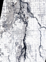
- Red River Flood Extent: April 14, 2009 12:40 UTC Satellite photos
- North Dakota State University's Fargo Flood website