

2002 Bou'in-Zahra earthquake
Encyclopedia
The 2002 Bou'in-Zahra earthquake (also known as the 2002 Avaj earthquake or the 2002 Changureh earthquake) occurred on June 22, 2002 in a region of northwestern Iran
which is crossed by several major fault line
s. The earthquake
's epicenter
was near the city of Bou'in-Zahra in Qazvin Province
, an area known for destructive earthquakes. Measuring 6.5 on the Richter scale and 6.3 on the moment magnitude scale
, the earthquake killed at least 261 people and injured 1,500 more. Over 20 aftershocks followed the earthquake.
According to the International Institute of Earthquake Engineering and Seismology (IIEES), the earthquake was felt as far away as the capital city of Tehran
, approximately 290 kilometres (180 mi) east of the epicenter, although no damage was reported there. Most houses in the region were single-story masonry
buildings, and virtually all of these collapsed. The public became angry due to the slow official response to victims who needed supplies. Residents of the town of Avaj
resorted to throwing stones at the car of a government minister.
between the Arabian Plate
and the Eurasian Plate
. Iran is crossed by several major faults, with 90% of them being seismically active and subject to many earthquakes each year; the area around the rupture experiences minor quakes almost daily. The most seismically active parts of this area are the Zagros fold and thrust belt
and the Alborz
mountain range. Qazvin Province
, which is located between these two zones, suffers less earthquakes, but these may be more powerful because stresses have longer to build.
The Bou'in-Zahra earthquake was located in an area of active thrust fault
ing and folding
, parallel and south of the southern edge of the Alborz
mountain range, and
was the 11th rupture in the previous two months in central Iran. An inversion of long-period P and SH body-wave seismograms indicated a rupture on a thrust fault
that dips 49 degrees to the southwest and had a centroid
depth of roughly 10 kilometres (6 mi). The rupture's mechanism
of faulting was reverse.
Multiple-event relocation of the main shock and aftershock epicenters and discontinuous surface ruptures recorded after the earthquake are compatible with northeastward movement on a southwest-dipping thrust, although maximum recorded displacements were less than would have been expected from the observed magnitude. This suggests that most of the slip did not actually reach the Earth's surface but caused folding at the surface. A previously unmapped thrust with little surface expression, the Abdareh fault, has been identified from the disruption of earlier drainage systems by the growth of the fold in its hanging wall, and is thought to be responsible for the earthquake. Such structures are known as blind thrusts, and have been responsible for many destructive earthquakes in Iran and elsewhere. The geomorphological effects of this particular fold have been partly obscured by the presence of an earlier Neogene
topography. The Qazvin region
was hit by an even greater earthquake
in 1962, which killed 12,200. In 1990 a rupture
killed over 40,000 people, injured 60,000, and left more than 500,000 homeless.
 The earthquake occurred at 02:58 UTC (7:28 a.m. Iran Standard Time), while many of the estimated 60 million Iranians affected were in their homes. Its duration was seven seconds, and the epicenter was near the settlement of Bou'in-Zahra in the Khar river valley, a mountainous farming region about 60 kilometres (37 mi) from the provincial capital of Qazvin
. The greatest damage was across an area best known for its seedless grape harvesting, a getaway for wealthy residents of Tehran. At least 261 people were killed, 1,500 injured, and 25,000 left homeless. An earlier death toll was reported as 500, but this number was believed to be inflated once it became known that some of the severely injured had been mistaken for dead. Most of the dead were women, children and the elderly, as many of the men were working in local vineyards. Over 20 aftershocks were recorded, with magnitudes up to 5.1 on the moment magnitude scale. At least three of these caused further casualties and damage, most of which were within a 25 kilometres (16 mi) radius of the main shock.
An estimated 5,000 buildings were damaged beyond repair. In the Qazvin province, 120 buildings were demolished and 50 villages suffered massive damage. In the neighboring Hamadan province, 45 villages were destroyed. A large majority of houses in the region were single-story masonry
buildings, and virtually all of these collapsed. As non-engineered structures, these could not withstand seismic forces, with structural failure and collapse resulting from wall-to-wall separation and the lack of structural integrity and of a proper lateral system of resisting. Newer structures built in accordance with the Iranian code of practice for seismic-resistant design
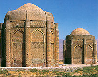
fared much better. Damage to the historic Kharaqan tomb towers, which were in a good state of preservation before the event, suggests that the earthquake was possibly one of the most powerful in the region for approximately 900 years.
At a station 28 kilometres (17 mi) from the epicenter, the maximum horizontal and vertical accelerations were recorded to be roughly 0.5 g
and 0.26 g. A bridge collapsed as a result of the disaster. Water and irrigation systems were severely damaged near the epicenter, and water facilities were demolished in nine villages. Many of the main water pipelines in the affected areas were damaged or destroyed, causing inadequacies in water availability and quality. Surface cracks were observed in Abdareh and Changureh, the villages that suffered the heaviest damage, being roughly 25 kilometres (16 mi) from the epicenter.
The relatively low levels of damage in the towns of Avaj or Ab-e-Garm in comparison to Changureh and Abdareh suggest a focus of damage to the northwest of the epicenter due to northwest propagation. In Changureh, only two buildings were left standing and over 120 casualties occurred. Abdareh also fared poorly; the disaster destroyed the town's only mosque
, toppled 40 homes and killed at least 20 people. North of Avaj
, in the village of Esmailabad, survivors recovered 38 corpses, a ninth of the total population, while searching for the missing, feared trapped in the ruins. In another village in the vicinity, Alaibad, two shepherds were the only known survivors. In the small village of Kisse-Jin, roughly 80 corpses were recovered following the rupture. Survivors crying and beating their heads and faces over loved ones were a common sight on Iranian state television.
The cost of the damage was estimated at US$91 million. The quake was felt across a wide area, including the provinces of Qazvin, Gilan
, Kurdistan
, Zanjan
, and Hamedan
. Of all these, Qazvin was the most heavily damaged, with an unnamed Qazvin official reporting that 177 had died in the province. It was also felt in the capital of Tehran
, roughly 290 kilometres (180 mi) east of the epicenter, although no serious damage was reported. However, Iranian journalist Borzou Daragahi reported that in Tehran he saw buildings sway and glass objects shatter.
s, 100 tons of food, 1,000 tents, 2,500 blankets, and mobile kitchens to the earthquake-stricken area. In addition, the Iranian army
supplied soldiers, machinery and water trucks. To prevent the spread of disease, villages were sprayed with disinfectants and their inhabitants were given tetanus
shots, among other measures. After Iranian officials launced an appeal for assistance, the United Nations Development Programme
supplied $50,000. The United Nations' Office for the Coordination of Humanitarian Affairs (OCHA) mobilised a United Nations Disaster Assessment and Coordination (UNDAC) team, deploying five members. Pope John Paul II
prayed for the earthquake victims and asked for a "generous" response.
United States
President George W. Bush
offered aid to Iran, which he had previously called part of an "axis of evil
". According to him, "human suffering knows no political boundaries" and he stood "ready to assist the people of Iran as needed and as desired". However, the Iranian government refused his help, though it called for the help of non-governmental agencies.
According to Hossein Rahnema, head of the Red Crescent in Changureh, the society "levelled an area to put up tents but most people wanted to stay next to their houses to look after their property". Survivors instead lit small fires amongst the rubble to protect against freezing temperatures. The Iranian President at the time, Mohammad Khatami
, declared three days of mourning and visited earthquake-stricken areas on June 25. Hospitals struggled to cope with the surplus of patients, discharging non-critical ones from their wards. The Associated Press
stated that 20 funerals were held on June 23, 2002 at a cemetery overlooking the village of Abdareh. A bank account was started to handle public donations for the families of the dead.
Often armed with no more than shovels and spades, soldiers and civilians dug for bodies in the rubble. Other than this, rescue workers were faced with a number of obstacles, including the temperatures of the villages damaged. They were warm during the day, although the villages grew colder at night, making rescue work harder and threatening the health of the homeless and anyone alive and trapped under the debris. Many civilians were discouraged from helping due to fear of aftershocks. According to Gary Oshea of International Rescue, the volunteers did not have enough technical equipment, and the religious leaders seemed unwilling to contribute much. Official rescue work ended on June 24, 2002, when rescue workers said there were no more survivors.
stated that only locals helped uncover the body of his child. In protest at Iran's slow response to the tragedy, some 300 people blocked the main road through Avaj. On June 23, "dozens" of Avaj residents threw stones at Interior Minister Abdolvahed Mousavi-Lari's car in anger at the government's delay in providing relief. They also claimed that the death toll was higher than official reports said it was.
On November 9, 2002, the World Bank
granted $225 million towards the reconstruction and economic rehabilitation of the area devastated by the quake. Reconstruction of housing and infrastructure by provincial authorities was interrupted for almost four months (November 2002 – February 2003) due to harsh weather conditions. In August 2003, the reconstruction was completed in all villages affected by the earthquake.
Iran
Iran , officially the Islamic Republic of Iran , is a country in Southern and Western Asia. The name "Iran" has been in use natively since the Sassanian era and came into use internationally in 1935, before which the country was known to the Western world as Persia...
which is crossed by several major fault line
Fault line
In geology, fault line refers to the surface trace of a fault.Fault line, Fault Line, or faultline may also refer to:* "Faultline", a song from the 2008 studio album Versus by The Haunted...
s. The earthquake
Earthquake
An earthquake is the result of a sudden release of energy in the Earth's crust that creates seismic waves. The seismicity, seismism or seismic activity of an area refers to the frequency, type and size of earthquakes experienced over a period of time...
's epicenter
Epicenter
The epicenter or epicentre is the point on the Earth's surface that is directly above the hypocenter or focus, the point where an earthquake or underground explosion originates...
was near the city of Bou'in-Zahra in Qazvin Province
Qazvin Province
The Qazvin Province is one of the 31 provinces of Iran. It is in the north-west of the country, and its center is the city of Qazvin. The province was created in 1993 out of part of Tehran Province and includes 20 cities: Qazvin, Takestan, Abyek, Buin-Zahra, Eqhbalieh, Mohammadieh, Alvand,...
, an area known for destructive earthquakes. Measuring 6.5 on the Richter scale and 6.3 on the moment magnitude scale
Moment magnitude scale
The moment magnitude scale is used by seismologists to measure the size of earthquakes in terms of the energy released. The magnitude is based on the seismic moment of the earthquake, which is equal to the rigidity of the Earth multiplied by the average amount of slip on the fault and the size of...
, the earthquake killed at least 261 people and injured 1,500 more. Over 20 aftershocks followed the earthquake.
According to the International Institute of Earthquake Engineering and Seismology (IIEES), the earthquake was felt as far away as the capital city of Tehran
Tehran
Tehran , sometimes spelled Teheran, is the capital of Iran and Tehran Province. With an estimated population of 8,429,807; it is also Iran's largest urban area and city, one of the largest cities in Western Asia, and is the world's 19th largest city.In the 20th century, Tehran was subject to...
, approximately 290 kilometres (180 mi) east of the epicenter, although no damage was reported there. Most houses in the region were single-story masonry
Masonry
Masonry is the building of structures from individual units laid in and bound together by mortar; the term masonry can also refer to the units themselves. The common materials of masonry construction are brick, stone, marble, granite, travertine, limestone; concrete block, glass block, stucco, and...
buildings, and virtually all of these collapsed. The public became angry due to the slow official response to victims who needed supplies. Residents of the town of Avaj
Avaj
Avaj is a city in and capital of Avaj District, in Buin Zahra County, Qazvin Province, Iran. At the 2006 census its population was 3,695, in 1,042 families....
resorted to throwing stones at the car of a government minister.
Background and tectonics
The northeastern part of Iran lies across part of the belt of active continental collisionContinental collision
Continental collision is a phenomenon of the plate tectonics of Earth that occurs at convergent boundaries. Continental collision is a variation on the fundamental process of subduction, whereby the subduction zone is destroyed, mountains produced, and two continents sutured together...
between the Arabian Plate
Arabian Plate
The Arabian Plate is one of three tectonic plates which have been moving northward over millions of years and colliding with the Eurasian Plate...
and the Eurasian Plate
Eurasian Plate
The Eurasian Plate is a tectonic plate which includes most of the continent of Eurasia , with the notable exceptions of the Indian subcontinent, the Arabian subcontinent, and the area east of the Chersky Range in East Siberia...
. Iran is crossed by several major faults, with 90% of them being seismically active and subject to many earthquakes each year; the area around the rupture experiences minor quakes almost daily. The most seismically active parts of this area are the Zagros fold and thrust belt
Zagros fold and thrust belt
The Zagros fold and thrust belt is a ~1800 km long zone of deformed crustal rocks, formed in the foreland of the collision between the Arabian Plate and the Eurasian Plate...
and the Alborz
Alborz
Alborz , also written as Alburz, Elburz or Elborz, is a mountain range in northern Iran stretching from the borders of Azerbaijan and Armenia in the northwest to the southern end of the Caspian Sea, and ending in the east at the borders of Turkmenistan and Afghanistan...
mountain range. Qazvin Province
Qazvin Province
The Qazvin Province is one of the 31 provinces of Iran. It is in the north-west of the country, and its center is the city of Qazvin. The province was created in 1993 out of part of Tehran Province and includes 20 cities: Qazvin, Takestan, Abyek, Buin-Zahra, Eqhbalieh, Mohammadieh, Alvand,...
, which is located between these two zones, suffers less earthquakes, but these may be more powerful because stresses have longer to build.
The Bou'in-Zahra earthquake was located in an area of active thrust fault
Thrust fault
A thrust fault is a type of fault, or break in the Earth's crust across which there has been relative movement, in which rocks of lower stratigraphic position are pushed up and over higher strata. They are often recognized because they place older rocks above younger...
ing and folding
Fold (geology)
The term fold is used in geology when one or a stack of originally flat and planar surfaces, such as sedimentary strata, are bent or curved as a result of permanent deformation. Synsedimentary folds are those due to slumping of sedimentary material before it is lithified. Folds in rocks vary in...
, parallel and south of the southern edge of the Alborz
Alborz
Alborz , also written as Alburz, Elburz or Elborz, is a mountain range in northern Iran stretching from the borders of Azerbaijan and Armenia in the northwest to the southern end of the Caspian Sea, and ending in the east at the borders of Turkmenistan and Afghanistan...
mountain range, and
was the 11th rupture in the previous two months in central Iran. An inversion of long-period P and SH body-wave seismograms indicated a rupture on a thrust fault
Thrust fault
A thrust fault is a type of fault, or break in the Earth's crust across which there has been relative movement, in which rocks of lower stratigraphic position are pushed up and over higher strata. They are often recognized because they place older rocks above younger...
that dips 49 degrees to the southwest and had a centroid
Centroid
In geometry, the centroid, geometric center, or barycenter of a plane figure or two-dimensional shape X is the intersection of all straight lines that divide X into two parts of equal moment about the line. Informally, it is the "average" of all points of X...
depth of roughly 10 kilometres (6 mi). The rupture's mechanism
Focal mechanism
The focal mechanism of an earthquake describes the inelastic deformation in the source region that generates the seismic waves. In the case of a fault-related event it refers to the orientation of the fault plane that slipped and the slip vector and is also known as a fault-plane solution...
of faulting was reverse.
Multiple-event relocation of the main shock and aftershock epicenters and discontinuous surface ruptures recorded after the earthquake are compatible with northeastward movement on a southwest-dipping thrust, although maximum recorded displacements were less than would have been expected from the observed magnitude. This suggests that most of the slip did not actually reach the Earth's surface but caused folding at the surface. A previously unmapped thrust with little surface expression, the Abdareh fault, has been identified from the disruption of earlier drainage systems by the growth of the fold in its hanging wall, and is thought to be responsible for the earthquake. Such structures are known as blind thrusts, and have been responsible for many destructive earthquakes in Iran and elsewhere. The geomorphological effects of this particular fold have been partly obscured by the presence of an earlier Neogene
Neogene
The Neogene is a geologic period and system in the International Commission on Stratigraphy Geologic Timescale starting 23.03 ± 0.05 million years ago and ending 2.588 million years ago...
topography. The Qazvin region
Qazvin Province
The Qazvin Province is one of the 31 provinces of Iran. It is in the north-west of the country, and its center is the city of Qazvin. The province was created in 1993 out of part of Tehran Province and includes 20 cities: Qazvin, Takestan, Abyek, Buin-Zahra, Eqhbalieh, Mohammadieh, Alvand,...
was hit by an even greater earthquake
1962 Bou'in-Zahra earthquake
The 1962 Bou'in-Zahra earthquake occurred on September 1, 1962, in the area of Bou'in-Zahra, Qazvin Province, Iran. 12,225 fatalities resulted from the massive, magnitude 7.1 earthquake....
in 1962, which killed 12,200. In 1990 a rupture
1990 Manjil-Rudbar earthquake
The Manjil-Rudbar Earthquake occurred at 00:30:09 on June 21, 1990 . It caused widespread damage in areas within a one hundred kilometer radius of the epicenter near the city of Rasht and about two hundred kilometers northwest of Tehran. The cities of Rudbar, Manjil, and Lushan and 700 villages...
killed over 40,000 people, injured 60,000, and left more than 500,000 homeless.
Damage and casualties
Qazvin
Qazvin is the largest city and capital of the Province of Qazvin in Iran. At the 2006 census, its population was 349,821, in 96,420 families....
. The greatest damage was across an area best known for its seedless grape harvesting, a getaway for wealthy residents of Tehran. At least 261 people were killed, 1,500 injured, and 25,000 left homeless. An earlier death toll was reported as 500, but this number was believed to be inflated once it became known that some of the severely injured had been mistaken for dead. Most of the dead were women, children and the elderly, as many of the men were working in local vineyards. Over 20 aftershocks were recorded, with magnitudes up to 5.1 on the moment magnitude scale. At least three of these caused further casualties and damage, most of which were within a 25 kilometres (16 mi) radius of the main shock.
An estimated 5,000 buildings were damaged beyond repair. In the Qazvin province, 120 buildings were demolished and 50 villages suffered massive damage. In the neighboring Hamadan province, 45 villages were destroyed. A large majority of houses in the region were single-story masonry
Masonry
Masonry is the building of structures from individual units laid in and bound together by mortar; the term masonry can also refer to the units themselves. The common materials of masonry construction are brick, stone, marble, granite, travertine, limestone; concrete block, glass block, stucco, and...
buildings, and virtually all of these collapsed. As non-engineered structures, these could not withstand seismic forces, with structural failure and collapse resulting from wall-to-wall separation and the lack of structural integrity and of a proper lateral system of resisting. Newer structures built in accordance with the Iranian code of practice for seismic-resistant design
Earthquake engineering
Earthquake engineering is the scientific field concerned with protecting society, the natural and the man-made environment from earthquakes by limiting the seismic risk to socio-economically acceptable levels...
fared much better. Damage to the historic Kharaqan tomb towers, which were in a good state of preservation before the event, suggests that the earthquake was possibly one of the most powerful in the region for approximately 900 years.
At a station 28 kilometres (17 mi) from the epicenter, the maximum horizontal and vertical accelerations were recorded to be roughly 0.5 g
Standard gravity
Standard gravity, or standard acceleration due to free fall, usually denoted by g0 or gn, is the nominal acceleration of an object in a vacuum near the surface of the Earth. It is defined as precisely , or about...
and 0.26 g. A bridge collapsed as a result of the disaster. Water and irrigation systems were severely damaged near the epicenter, and water facilities were demolished in nine villages. Many of the main water pipelines in the affected areas were damaged or destroyed, causing inadequacies in water availability and quality. Surface cracks were observed in Abdareh and Changureh, the villages that suffered the heaviest damage, being roughly 25 kilometres (16 mi) from the epicenter.
The relatively low levels of damage in the towns of Avaj or Ab-e-Garm in comparison to Changureh and Abdareh suggest a focus of damage to the northwest of the epicenter due to northwest propagation. In Changureh, only two buildings were left standing and over 120 casualties occurred. Abdareh also fared poorly; the disaster destroyed the town's only mosque
Mosque
A mosque is a place of worship for followers of Islam. The word is likely to have entered the English language through French , from Portuguese , from Spanish , and from Berber , ultimately originating in — . The Arabic word masjid literally means a place of prostration...
, toppled 40 homes and killed at least 20 people. North of Avaj
Avaj
Avaj is a city in and capital of Avaj District, in Buin Zahra County, Qazvin Province, Iran. At the 2006 census its population was 3,695, in 1,042 families....
, in the village of Esmailabad, survivors recovered 38 corpses, a ninth of the total population, while searching for the missing, feared trapped in the ruins. In another village in the vicinity, Alaibad, two shepherds were the only known survivors. In the small village of Kisse-Jin, roughly 80 corpses were recovered following the rupture. Survivors crying and beating their heads and faces over loved ones were a common sight on Iranian state television.
The cost of the damage was estimated at US$91 million. The quake was felt across a wide area, including the provinces of Qazvin, Gilan
Gilan Province
Gilan Province is one of the 31 provinces of Iran. It lies along the Caspian Sea, just west of the province of Mazandaran, east of the province of Ardabil, north of the provinces of Zanjan and Qazvin....
, Kurdistan
Kurdistan Province (Iran)
Kurdistan Province or Kordestan Province or Kurdestan Province is one of the 31 provinces of Iran, not to be confused with the greater geographical area of Iranian Kurdistan. The province of Kurdistan is 28,817 km² in area which encompasses just one-fourth of the Kurdish inhabited areas of Iran or...
, Zanjan
Zanjan Province
Zanjan Province is one of the 31 provinces of Iran. Located in the North West of Iran, its capital is Zanjan city. Zanjan province with an area of 36,400 km² has a mostly rural, population of 964,601 . The province lies 330 km northwest of Tehran, connected to it via a freeway.Zanjan...
, and Hamedan
Hamadan Province
Hamedan Province is one of the 31 provinces of Iran. Its center is Hamedan city. The province of Hamedan covers an area of 19,546 km². In the year 1996, Hamedan province had a population of approximately 1.7 million people....
. Of all these, Qazvin was the most heavily damaged, with an unnamed Qazvin official reporting that 177 had died in the province. It was also felt in the capital of Tehran
Tehran
Tehran , sometimes spelled Teheran, is the capital of Iran and Tehran Province. With an estimated population of 8,429,807; it is also Iran's largest urban area and city, one of the largest cities in Western Asia, and is the world's 19th largest city.In the 20th century, Tehran was subject to...
, roughly 290 kilometres (180 mi) east of the epicenter, although no serious damage was reported. However, Iranian journalist Borzou Daragahi reported that in Tehran he saw buildings sway and glass objects shatter.
Landslides
The Bou'in-Zahra earthquake triggered 59 landslides over an area of about 3600 square kilometres (1,390 sq mi). Landslides formed due to the quake included 47 falls and topples, nine slides, and three lateral spreads. The largest of these slides was a rockslide, 150 × 100 m (490 × 330 ft), which occurred southeast of Changureh. Landslides triggered by the quake occurred more often in the geologic areas most susceptible to damage, where there were many landslides before.Relief efforts and aftermath
The Red Crescent Society sent relief workers, detection dogDetection dog
A detection dog or sniffer dog is a dog that is trained to and works at using its senses to detect substances such as explosives, illegal drugs, or blood. Hunting dogs that search for game and search dogs that search for missing humans are generally not considered detection dogs...
s, 100 tons of food, 1,000 tents, 2,500 blankets, and mobile kitchens to the earthquake-stricken area. In addition, the Iranian army
Military of Iran
The Armed Forces of the Islamic Republic of Iran include the IRIA and the IRGC and the Police Force .These forces total about 545,000 active personnel . All branches of armed forces fall under the command of General Headquarters of Armed Forces...
supplied soldiers, machinery and water trucks. To prevent the spread of disease, villages were sprayed with disinfectants and their inhabitants were given tetanus
Tetanus
Tetanus is a medical condition characterized by a prolonged contraction of skeletal muscle fibers. The primary symptoms are caused by tetanospasmin, a neurotoxin produced by the Gram-positive, rod-shaped, obligate anaerobic bacterium Clostridium tetani...
shots, among other measures. After Iranian officials launced an appeal for assistance, the United Nations Development Programme
United Nations Development Programme
The United Nations Development Programme is the United Nations' global development network. It advocates for change and connects countries to knowledge, experience and resources to help people build a better life. UNDP operates in 177 countries, working with nations on their own solutions to...
supplied $50,000. The United Nations' Office for the Coordination of Humanitarian Affairs (OCHA) mobilised a United Nations Disaster Assessment and Coordination (UNDAC) team, deploying five members. Pope John Paul II
Pope John Paul II
Blessed Pope John Paul II , born Karol Józef Wojtyła , reigned as Pope of the Catholic Church and Sovereign of Vatican City from 16 October 1978 until his death on 2 April 2005, at of age. His was the second-longest documented pontificate, which lasted ; only Pope Pius IX ...
prayed for the earthquake victims and asked for a "generous" response.
United States
United States
The United States of America is a federal constitutional republic comprising fifty states and a federal district...
President George W. Bush
George W. Bush
George Walker Bush is an American politician who served as the 43rd President of the United States, from 2001 to 2009. Before that, he was the 46th Governor of Texas, having served from 1995 to 2000....
offered aid to Iran, which he had previously called part of an "axis of evil
Axis of evil
"Axis of evil" is a term initially used by the former United States President George W. Bush in his State of the Union Address on January 29, 2002 and often repeated throughout his presidency, describing governments that he accused of helping terrorism and seeking weapons of mass destruction...
". According to him, "human suffering knows no political boundaries" and he stood "ready to assist the people of Iran as needed and as desired". However, the Iranian government refused his help, though it called for the help of non-governmental agencies.
According to Hossein Rahnema, head of the Red Crescent in Changureh, the society "levelled an area to put up tents but most people wanted to stay next to their houses to look after their property". Survivors instead lit small fires amongst the rubble to protect against freezing temperatures. The Iranian President at the time, Mohammad Khatami
Mohammad Khatami
Sayyid Mohammad Khātamī is an Iranian scholar, philosopher, Shiite theologian and Reformist politician. He served as the fifth President of Iran from August 2, 1997 to August 3, 2005. He also served as Iran's Minister of Culture in both the 1980s and 1990s...
, declared three days of mourning and visited earthquake-stricken areas on June 25. Hospitals struggled to cope with the surplus of patients, discharging non-critical ones from their wards. The Associated Press
Associated Press
The Associated Press is an American news agency. The AP is a cooperative owned by its contributing newspapers, radio and television stations in the United States, which both contribute stories to the AP and use material written by its staff journalists...
stated that 20 funerals were held on June 23, 2002 at a cemetery overlooking the village of Abdareh. A bank account was started to handle public donations for the families of the dead.
Often armed with no more than shovels and spades, soldiers and civilians dug for bodies in the rubble. Other than this, rescue workers were faced with a number of obstacles, including the temperatures of the villages damaged. They were warm during the day, although the villages grew colder at night, making rescue work harder and threatening the health of the homeless and anyone alive and trapped under the debris. Many civilians were discouraged from helping due to fear of aftershocks. According to Gary Oshea of International Rescue, the volunteers did not have enough technical equipment, and the religious leaders seemed unwilling to contribute much. Official rescue work ended on June 24, 2002, when rescue workers said there were no more survivors.
Public reaction
Of the roughly 80 villages that suffered heavy damage, the Iranian government claimed that relief work was mostly complete. Residents of Changureh, however, complained that tents, food, and medicine had not reached them, after waiting in near-freezing temperatures. A man from AvajAvaj
Avaj is a city in and capital of Avaj District, in Buin Zahra County, Qazvin Province, Iran. At the 2006 census its population was 3,695, in 1,042 families....
stated that only locals helped uncover the body of his child. In protest at Iran's slow response to the tragedy, some 300 people blocked the main road through Avaj. On June 23, "dozens" of Avaj residents threw stones at Interior Minister Abdolvahed Mousavi-Lari's car in anger at the government's delay in providing relief. They also claimed that the death toll was higher than official reports said it was.
Reconstruction
Electricity was restored to affected areas by June 25.On November 9, 2002, the World Bank
World Bank
The World Bank is an international financial institution that provides loans to developing countries for capital programmes.The World Bank's official goal is the reduction of poverty...
granted $225 million towards the reconstruction and economic rehabilitation of the area devastated by the quake. Reconstruction of housing and infrastructure by provincial authorities was interrupted for almost four months (November 2002 – February 2003) due to harsh weather conditions. In August 2003, the reconstruction was completed in all villages affected by the earthquake.