
1976 Atlantic hurricane season
Encyclopedia
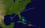
The 1976 Atlantic hurricane season officially began on June 1, 1976, and lasted until November 30, 1976. These dates conventionally delimit the period of each year when most tropical cyclone
s form in the Atlantic basin
. The season
was average in activity, with ten total storms and six hurricanes forming.
Although several storms made landfall in 1976, only Hurricane Belle caused significant damage when it hit New England
in August, causing $100 million in damage. Hurricane Emmy
caused 68 indirect deaths when a Venezuela
n Air Force plane carrying a school choir crashed on a landing attempt at Lajes Air Base in the Azores
during the storm.
(ACE) rating of 84. ACE is, broadly speaking, a measure of the power of the hurricane multiplied by the length of time it existed, so storms that last a long time, as well as particularly strong hurricanes, have high ACEs. ACE is only calculated for full advisories on tropical systems at or exceeding 34 knots (39 mph, 63 km/h) or tropical storm strength. Subtropical storms are not included, therefore, the subtropical stage of Anna is omitted from the total ACE value.
. Slowly, the system organized, first to a subtropical depression
on May 21, then to a subtropical storm on May 23. The storm began to move faster, and on May 23, it hit the Florida Panhandle
. After moving across Georgia
at a forward motion of 25 mph (40.2 km/h) the storm reached its peak of maximum sustained wind
s reaching 50 mph (85 km/h) while southeast of the Carolinas on May 24. It merged with a frontal system on May 25. Heavy rainfall was associated with the system, but little damage occurred.
. It began as a subtropical depression on July 28, and strengthened to Subtropical Storm Two on July 30. That afternoon it rapidly acquired tropical characteristics, and was named Anna. Anna reached its peak of 45 mph (75 km/h) winds that day, but became extratropical on August 1. Steering currents were weak, so the system made a slow counterclockwise loop around the Azores
before dissipating on August 6.
, New York
as a tropical storm, causing $100 million in damage (1976 USD) and five casualties.
was located south of Bermuda
. Over the next week, the system warmed and moved toward the surface. On August 18, it became a tropical depression, and later that day, it was named Tropical Storm Candice. Moving to the northeast, it remained weak until August 21, when it rapidly became a hurricane, located at 41ºN, 400 miles (643.7 km) east of Cape Cod
. When Candice became a hurricane, it was one of only seven hurricanes to reach hurricane strength north of 40ºN. Soon after, Candice rapidly moved to the northeast, and it lost its identity to a cold front on August 24.
, on August 17. This low became a tropical depression on August 18. After drifting to the east-southeast, a pressure of a 1004 mbar (29.6 inHg) occurred on August 19. The storm rapidly moved to the northeast, reaching tropical storm strength on the way. After passing over Florida
, Dottie moved to the north, reaching a peak of 50 mph (85 km/h) winds. Conditions appeared favorable, and a hurricane watch was issued. However, upper-level winds ripped the storm apart on August 20, and it was barely a tropical storm at its South Carolina
landfall on August 21. It weakened to a tropical depression, and advisories were stopped, later on August 21. A tide in Atlanta Beach, North Carolina reached 3.5 feet (1.1 m) above normal. The remnant low of the system followed its track, moving southwestward into Florida, bringing more rain to the area. A total of 10.68 in (271.3 mm) of rain fell at Fort Lauderdale. Dottie lost its identity after re-entering the Gulf of Mexico
on August 25. Damage was minor, but four deaths occurred due to a fishing boat sinking over the Bahamas.
. As it moved west-northwestward, the area strengthened to a tropical storm on August 22. On August 24, it recurved to the northeastward, and strengthened to a hurricane on August 25. Its eastward movement so early in the year is almost unprecedented, as it occurred from the rapid development of a low pressure system to its northeast. Emmy moved recurved back northwest on August 26, but again moved eastward on August 29, when it reached its peak of 105 mph (165 km/h). It gradually weakened, and on September 4, a weakened extratropical Emmy was absorbed by the larger circulation of Hurricane Frances while located over the Azores
.
Hurricane Emmy caused 68 indirect deaths when a Venezuela
n Air Force plane carrying a school choir crashed on a landing attempt at Lajes Air Base in the Azores
during the storm. This makes Hurricane Emmy the fifth documented storm to have downed an airplane (the others were Hurricane Janet
, Typhoon Emma, Hurricane Betsy
and Hurricane Esther).
and the coast of Africa
. The next day, it became a tropical storm, and on August 30, Frances became a hurricane. As it recurved to the north and east, Frances reached its peak of 115 mph (185 km/h) on September 1. Steady weakening occurred afterwards, and Frances became extratropical on September 4.
. As it moved north-northeastward, it developed a circulation and became a subtropical depression on September 13. The next day it became a subtropical storm, and reached its peak of 45 mph (75 km/h) over the western tropical Atlantic, off the coast of Georgia
. The storm quickly made landfall near Charleston, South Carolina
, and dissipated over southern Virginia
on September 17.
. On September 27 while moving northward, it strengthened to become Tropical Storm Gloria. After moving northwestward for a day, Gloria moved northeast, strengthening to a 105 mph (165 km/h) hurricane on September 30. Steady weakening ensued, and Gloria lost its tropical characteristics on October 4.
on October 22. After a day, the storm became Tropical Storm Holly, strengthening to Hurricane Holly on October 24. Holly weakened to a tropical storm on October 25. The storm became extratropical on October 28 while located 400 miles (643.7 km) northwest of the Azores
islands.
in 1976. Storms were named Belle, Candice, Dottie, Emmy and Gloria for the first time in 1976. Names that were not assigned are marked in . This is the last time these names have been used except for Gloria, Frances and Maria.
Tropical cyclone
A tropical cyclone is a storm system characterized by a large low-pressure center and numerous thunderstorms that produce strong winds and heavy rain. Tropical cyclones strengthen when water evaporated from the ocean is released as the saturated air rises, resulting in condensation of water vapor...
s form in the Atlantic basin
Atlantic Basin
The Atlantic Basin is the Atlantic Ocean.Atlantic Basin may also refer to:* Atlantic Basin Iron Works, an ironworks that operated in Brooklyn, New York, in the early to mid-20th century...
. The season
Atlantic hurricane season
The Atlantic hurricane season is the period in a year when hurricanes usually form in the Atlantic Ocean. Tropical cyclones in the North Atlantic are called hurricanes, tropical storms, or tropical depressions. In addition, there have been several storms over the years that have not been fully...
was average in activity, with ten total storms and six hurricanes forming.
Although several storms made landfall in 1976, only Hurricane Belle caused significant damage when it hit New England
New England
New England is a region in the northeastern corner of the United States consisting of the six states of Maine, New Hampshire, Vermont, Massachusetts, Rhode Island, and Connecticut...
in August, causing $100 million in damage. Hurricane Emmy
Hurricane Emmy (1976)
Hurricane Emmy was the longest-lived hurricane of the 1976 Atlantic hurricane season. The fifth tropical cyclone and the third hurricane of the season, Emmy developed from a tropical wave on August 20 to the east of the Lesser Antilles...
caused 68 indirect deaths when a Venezuela
Venezuela
Venezuela , officially called the Bolivarian Republic of Venezuela , is a tropical country on the northern coast of South America. It borders Colombia to the west, Guyana to the east, and Brazil to the south...
n Air Force plane carrying a school choir crashed on a landing attempt at Lajes Air Base in the Azores
Azores
The Archipelago of the Azores is composed of nine volcanic islands situated in the middle of the North Atlantic Ocean, and is located about west from Lisbon and about east from the east coast of North America. The islands, and their economic exclusion zone, form the Autonomous Region of the...
during the storm.
Season summary
The season's activity was reflected with a cumulative accumulated cyclone energyAccumulated cyclone energy
Accumulated cyclone energy is a measure used by the National Oceanic and Atmospheric Administration to express the activity of individual tropical cyclones and entire tropical cyclone seasons, particularly the North Atlantic hurricane season. It uses an approximation of the energy used by a...
(ACE) rating of 84. ACE is, broadly speaking, a measure of the power of the hurricane multiplied by the length of time it existed, so storms that last a long time, as well as particularly strong hurricanes, have high ACEs. ACE is only calculated for full advisories on tropical systems at or exceeding 34 knots (39 mph, 63 km/h) or tropical storm strength. Subtropical storms are not included, therefore, the subtropical stage of Anna is omitted from the total ACE value.
Subtropical Storm One
On May 19 an upper-level trough produced widespread thunderstorms over the Gulf of MexicoGulf of Mexico
The Gulf of Mexico is a partially landlocked ocean basin largely surrounded by the North American continent and the island of Cuba. It is bounded on the northeast, north and northwest by the Gulf Coast of the United States, on the southwest and south by Mexico, and on the southeast by Cuba. In...
. Slowly, the system organized, first to a subtropical depression
Subtropical cyclone
A subtropical cyclone is a weather system that has some characteristics of a tropical and an extratropical cyclone. As early as the 1950s, meteorologists were unclear whether they should be characterized as tropical or extratropical cyclones. They were officially recognized by the National...
on May 21, then to a subtropical storm on May 23. The storm began to move faster, and on May 23, it hit the Florida Panhandle
Florida Panhandle
The Florida Panhandle, an informal, unofficial term for the northwestern part of Florida, is a strip of land roughly 200 miles long and 50 to 100 miles wide , lying between Alabama on the north and the west, Georgia also on the north, and the Gulf of Mexico to the south. Its eastern boundary is...
. After moving across Georgia
Georgia (U.S. state)
Georgia is a state located in the southeastern United States. It was established in 1732, the last of the original Thirteen Colonies. The state is named after King George II of Great Britain. Georgia was the fourth state to ratify the United States Constitution, on January 2, 1788...
at a forward motion of 25 mph (40.2 km/h) the storm reached its peak of maximum sustained wind
Maximum sustained wind
The maximum sustained winds associated with a tropical cyclone are a common indicator of the intensity of the storm. Within a mature tropical cyclone, they are found within the eyewall at a distance defined as the radius of maximum wind, or RMW. Unlike gusts, the value of these winds are...
s reaching 50 mph (85 km/h) while southeast of the Carolinas on May 24. It merged with a frontal system on May 25. Heavy rainfall was associated with the system, but little damage occurred.
Tropical Storm Anna
The system that became Tropical Storm Anna formed in the central Atlantic, several hundred miles southeast of BermudaBermuda
Bermuda is a British overseas territory in the North Atlantic Ocean. Located off the east coast of the United States, its nearest landmass is Cape Hatteras, North Carolina, about to the west-northwest. It is about south of Halifax, Nova Scotia, Canada, and northeast of Miami, Florida...
. It began as a subtropical depression on July 28, and strengthened to Subtropical Storm Two on July 30. That afternoon it rapidly acquired tropical characteristics, and was named Anna. Anna reached its peak of 45 mph (75 km/h) winds that day, but became extratropical on August 1. Steering currents were weak, so the system made a slow counterclockwise loop around the Azores
Azores
The Archipelago of the Azores is composed of nine volcanic islands situated in the middle of the North Atlantic Ocean, and is located about west from Lisbon and about east from the east coast of North America. The islands, and their economic exclusion zone, form the Autonomous Region of the...
before dissipating on August 6.
Hurricane Belle
Hurricane Belle was a major hurricane that threatened much of the East Coast of the United States. It made landfall in Long IslandLong Island
Long Island is an island located in the southeast part of the U.S. state of New York, just east of Manhattan. Stretching northeast into the Atlantic Ocean, Long Island contains four counties, two of which are boroughs of New York City , and two of which are mainly suburban...
, New York
New York
New York is a state in the Northeastern region of the United States. It is the nation's third most populous state. New York is bordered by New Jersey and Pennsylvania to the south, and by Connecticut, Massachusetts and Vermont to the east...
as a tropical storm, causing $100 million in damage (1976 USD) and five casualties.
Hurricane Candice
On August 11, a cold-core lowCold-core low
A cold-core low, also known as a cold low or cold-core cyclone, is a cyclone aloft which has an associated cold pool of air residing at high altitude within the Earth's troposphere. It is a low pressure system which strengthens with height in accordance with the thermal wind relationship. These...
was located south of Bermuda
Bermuda
Bermuda is a British overseas territory in the North Atlantic Ocean. Located off the east coast of the United States, its nearest landmass is Cape Hatteras, North Carolina, about to the west-northwest. It is about south of Halifax, Nova Scotia, Canada, and northeast of Miami, Florida...
. Over the next week, the system warmed and moved toward the surface. On August 18, it became a tropical depression, and later that day, it was named Tropical Storm Candice. Moving to the northeast, it remained weak until August 21, when it rapidly became a hurricane, located at 41ºN, 400 miles (643.7 km) east of Cape Cod
Cape Cod
Cape Cod, often referred to locally as simply the Cape, is a cape in the easternmost portion of the state of Massachusetts, in the Northeastern United States...
. When Candice became a hurricane, it was one of only seven hurricanes to reach hurricane strength north of 40ºN. Soon after, Candice rapidly moved to the northeast, and it lost its identity to a cold front on August 24.
Tropical Storm Dottie
A strong upper level trough led to the formation of a low pressure area in the eastern Gulf of MexicoGulf of Mexico
The Gulf of Mexico is a partially landlocked ocean basin largely surrounded by the North American continent and the island of Cuba. It is bounded on the northeast, north and northwest by the Gulf Coast of the United States, on the southwest and south by Mexico, and on the southeast by Cuba. In...
, on August 17. This low became a tropical depression on August 18. After drifting to the east-southeast, a pressure of a 1004 mbar (29.6 inHg) occurred on August 19. The storm rapidly moved to the northeast, reaching tropical storm strength on the way. After passing over Florida
Florida
Florida is a state in the southeastern United States, located on the nation's Atlantic and Gulf coasts. It is bordered to the west by the Gulf of Mexico, to the north by Alabama and Georgia and to the east by the Atlantic Ocean. With a population of 18,801,310 as measured by the 2010 census, it...
, Dottie moved to the north, reaching a peak of 50 mph (85 km/h) winds. Conditions appeared favorable, and a hurricane watch was issued. However, upper-level winds ripped the storm apart on August 20, and it was barely a tropical storm at its South Carolina
South Carolina
South Carolina is a state in the Deep South of the United States that borders Georgia to the south, North Carolina to the north, and the Atlantic Ocean to the east. Originally part of the Province of Carolina, the Province of South Carolina was one of the 13 colonies that declared independence...
landfall on August 21. It weakened to a tropical depression, and advisories were stopped, later on August 21. A tide in Atlanta Beach, North Carolina reached 3.5 feet (1.1 m) above normal. The remnant low of the system followed its track, moving southwestward into Florida, bringing more rain to the area. A total of 10.68 in (271.3 mm) of rain fell at Fort Lauderdale. Dottie lost its identity after re-entering the Gulf of Mexico
Gulf of Mexico
The Gulf of Mexico is a partially landlocked ocean basin largely surrounded by the North American continent and the island of Cuba. It is bounded on the northeast, north and northwest by the Gulf Coast of the United States, on the southwest and south by Mexico, and on the southeast by Cuba. In...
on August 25. Damage was minor, but four deaths occurred due to a fishing boat sinking over the Bahamas.
Hurricane Emmy
The tropical depression that became Hurricane Emmy developed on August 20 from a tropical wave, located about 1000 mi (1,609.3 km) east of the Lesser AntillesLesser Antilles
The Lesser Antilles are a long, partly volcanic island arc in the Western Hemisphere. Most of its islands form the eastern boundary of the Caribbean Sea with the Atlantic Ocean, with the remainder located in the southern Caribbean just north of South America...
. As it moved west-northwestward, the area strengthened to a tropical storm on August 22. On August 24, it recurved to the northeastward, and strengthened to a hurricane on August 25. Its eastward movement so early in the year is almost unprecedented, as it occurred from the rapid development of a low pressure system to its northeast. Emmy moved recurved back northwest on August 26, but again moved eastward on August 29, when it reached its peak of 105 mph (165 km/h). It gradually weakened, and on September 4, a weakened extratropical Emmy was absorbed by the larger circulation of Hurricane Frances while located over the Azores
Azores
The Archipelago of the Azores is composed of nine volcanic islands situated in the middle of the North Atlantic Ocean, and is located about west from Lisbon and about east from the east coast of North America. The islands, and their economic exclusion zone, form the Autonomous Region of the...
.
Hurricane Emmy caused 68 indirect deaths when a Venezuela
Venezuela
Venezuela , officially called the Bolivarian Republic of Venezuela , is a tropical country on the northern coast of South America. It borders Colombia to the west, Guyana to the east, and Brazil to the south...
n Air Force plane carrying a school choir crashed on a landing attempt at Lajes Air Base in the Azores
Azores
The Archipelago of the Azores is composed of nine volcanic islands situated in the middle of the North Atlantic Ocean, and is located about west from Lisbon and about east from the east coast of North America. The islands, and their economic exclusion zone, form the Autonomous Region of the...
during the storm. This makes Hurricane Emmy the fifth documented storm to have downed an airplane (the others were Hurricane Janet
Hurricane Janet
Hurricane Janet was the most powerful hurricane of the 1955 Atlantic hurricane season and one of the strongest Atlantic hurricanes on record. It made landfall as a Category 5 hurricane on the Saffir-Simpson Hurricane Scale, causing catastrophic damage and at least 687 deaths in the Lesser...
, Typhoon Emma, Hurricane Betsy
Hurricane Betsy (1956)
Hurricane Betsy in 1956 was the first Atlantic hurricane to make landfall in Puerto Rico in 24 years. The third tropical cyclone of the 1956 Atlantic hurricane season, Betsy developed from a tropical wave on August 9 to the east of the Lesser Antilles. It rapidly developed into a...
and Hurricane Esther).
Hurricane Frances
Like Emmy, the tropical depression that became Hurricane Frances formed from a tropical wave on August 27, while midway between the Lesser AntillesLesser Antilles
The Lesser Antilles are a long, partly volcanic island arc in the Western Hemisphere. Most of its islands form the eastern boundary of the Caribbean Sea with the Atlantic Ocean, with the remainder located in the southern Caribbean just north of South America...
and the coast of Africa
Africa
Africa is the world's second largest and second most populous continent, after Asia. At about 30.2 million km² including adjacent islands, it covers 6% of the Earth's total surface area and 20.4% of the total land area...
. The next day, it became a tropical storm, and on August 30, Frances became a hurricane. As it recurved to the north and east, Frances reached its peak of 115 mph (185 km/h) on September 1. Steady weakening occurred afterwards, and Frances became extratropical on September 4.
Subtropical Storm Three
On September 12, the interaction between mid-tropospheric low and a diffuse stationary front led to the formation of a low pressure system over central FloridaFlorida
Florida is a state in the southeastern United States, located on the nation's Atlantic and Gulf coasts. It is bordered to the west by the Gulf of Mexico, to the north by Alabama and Georgia and to the east by the Atlantic Ocean. With a population of 18,801,310 as measured by the 2010 census, it...
. As it moved north-northeastward, it developed a circulation and became a subtropical depression on September 13. The next day it became a subtropical storm, and reached its peak of 45 mph (75 km/h) over the western tropical Atlantic, off the coast of Georgia
Georgia (U.S. state)
Georgia is a state located in the southeastern United States. It was established in 1732, the last of the original Thirteen Colonies. The state is named after King George II of Great Britain. Georgia was the fourth state to ratify the United States Constitution, on January 2, 1788...
. The storm quickly made landfall near Charleston, South Carolina
Charleston, South Carolina
Charleston is the second largest city in the U.S. state of South Carolina. It was made the county seat of Charleston County in 1901 when Charleston County was founded. The city's original name was Charles Towne in 1670, and it moved to its present location from a location on the west bank of the...
, and dissipated over southern Virginia
Virginia
The Commonwealth of Virginia , is a U.S. state on the Atlantic Coast of the Southern United States. Virginia is nicknamed the "Old Dominion" and sometimes the "Mother of Presidents" after the eight U.S. presidents born there...
on September 17.
Hurricane Gloria
A tropical wave became a tropical depression on September 26, located 400 miles (643.7 km) northeast of the Lesser AntillesLesser Antilles
The Lesser Antilles are a long, partly volcanic island arc in the Western Hemisphere. Most of its islands form the eastern boundary of the Caribbean Sea with the Atlantic Ocean, with the remainder located in the southern Caribbean just north of South America...
. On September 27 while moving northward, it strengthened to become Tropical Storm Gloria. After moving northwestward for a day, Gloria moved northeast, strengthening to a 105 mph (165 km/h) hurricane on September 30. Steady weakening ensued, and Gloria lost its tropical characteristics on October 4.
Hurricane Holly
The tropical depression that became Hurricane Holly formed from a tropical wave 200 miles (321.9 km) east of the northern Lesser AntillesLesser Antilles
The Lesser Antilles are a long, partly volcanic island arc in the Western Hemisphere. Most of its islands form the eastern boundary of the Caribbean Sea with the Atlantic Ocean, with the remainder located in the southern Caribbean just north of South America...
on October 22. After a day, the storm became Tropical Storm Holly, strengthening to Hurricane Holly on October 24. Holly weakened to a tropical storm on October 25. The storm became extratropical on October 28 while located 400 miles (643.7 km) northwest of the Azores
Azores
The Archipelago of the Azores is composed of nine volcanic islands situated in the middle of the North Atlantic Ocean, and is located about west from Lisbon and about east from the east coast of North America. The islands, and their economic exclusion zone, form the Autonomous Region of the...
islands.
Season summary
Storm names
The following names were used for named storms (tropical storms and hurricanes) that formed in the Atlantic basinAtlantic Basin
The Atlantic Basin is the Atlantic Ocean.Atlantic Basin may also refer to:* Atlantic Basin Iron Works, an ironworks that operated in Brooklyn, New York, in the early to mid-20th century...
in 1976. Storms were named Belle, Candice, Dottie, Emmy and Gloria for the first time in 1976. Names that were not assigned are marked in . This is the last time these names have been used except for Gloria, Frances and Maria.
|
|
Retirement
None of the names from the 1976 season were retired.See also
- List of Atlantic hurricanes
- List of Atlantic hurricane seasons
- 1976 Pacific hurricane season1976 Pacific hurricane seasonThe 1976 Pacific hurricane season was a very deadly and costly one. Hurricanes Kathleen, Liza, and Madeline were the most notable storms this year. Hurricane Kathleen caused death and destruction in California and Arizona due to flooding. Hurricane Liza was the deadliest storm of the season when it...
- 1976 Pacific typhoon season1976 Pacific typhoon seasonThe 1976 Pacific typhoon season has no official bounds; it ran year-round in 1976, but most tropical cyclones tend to form in the northwestern Pacific Ocean between June and December...
- 1976 North Indian Ocean cyclone season
- Southern Hemisphere tropical cyclone seasons: 1975–76, 1976–77