
Hurricane Belle
Encyclopedia
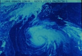
Hurricane Belle was the third tropical storm and first hurricane of the 1976 Atlantic hurricane season
. The system formed as a tropical depression northeast of the Bahamas and strengthened as it moved northward towards New York and New England. Belle became a major hurricane that threatened much of the East Coast of the United States
. However, the storm weakened prior to landfall and struck Long Island, New York, as a Category-1 hurricane, spreading moderate to heavy rainfall from eastern North Carolina
through New England
. The system evolved into an extratropical cyclone
as it passed through New England. Belle caused $100 million (1976 US dollars) in damage.
. It moved quickly across the Atlantic Ocean at speeds up to 23 mi/h, and slowly organized with a large area of convection with a possible low level circulation as early as July 31. The convection became detached from the wave, and moved northwestward to a position near the Bahamas. As it remained stationary, it developed a circulation and became a tropical depression on August 6. Under weak steering currents, it looped, and was upgraded to Tropical Storm Belle early on August 7.
Belle drifted to the west-northwest, and attained hurricane status late on August 7. On the 8th, the storm turned to the north, where conditions favored additional strengthening. Late on the 8th, Belle reached major hurricane status, and early on the 9th, it peaked at 120 mi/h while east of Florida
. During this time, Hurricane Warnings were posted from Georgia
to eventually Maine
.
Belle accelerated to the north-northeast and paralleled the United States
coastline. After peaking on August 9, the hurricane weakened, possibly due to cooler waters off the North Carolina
coast. It continued to parallel the coastline, remaining within 100 miles (160.9 km) off the coast. Just after midnight on August 10, Belle made landfall on the South Shore of Long Island, NY, near Jones Beach
, as a Category-1 hurricane with winds of 75 mph (120 km/h) and a central pressure of 980 mb. It rapidly weakened over land, and became extratropical later that day over New England
.
 Due to the close proximity of Belle and the east coast of the United States, Hurricane Watches were issued for areas between Georgia and Maine at some point during the storm's existence. Officials advised residents near the coastline to evacuate to safer areas further inland. At least 40,000 non-residents evacuated on August 8 from North Carolina beaches to escape the storm. An estimated 6,200 residents evacuated to Red Cross shelters as Belle threatened North Carolina.
With Hurricane Belle expected to produce a storm surge
rivaling that of Hurricane Donna
in 1960, officials in New York immediately began preparations. Police officers handed out sandbags to residents in low-lying areas and National Guard armories and some public schools were used as evacuation centers. An estimated 11,000 residents took shelter in these places during the storm. Numerous flights in and out of New York were cancelled, Wall Street
was closed and the United Nations
postponed a meeting. An estimated 30,000 and 250,000 people evacuated from New York and New Jersey respectively. Summer tourist evacuated from most beaches but many residents decided to stay. In Connecticut, 52 helicopters and 100 pilots were placed on standby for possible relief missions following the storm. The Red Cross reported that about 2,300 people evacuated Cape Cod
and thousands of tourists left the area.
 Five people were killed in North Carolina when a car and truck collided on a rain-slicked highway near the Virginia border. The outer bands
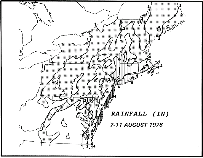
of Belle produced heavy rain, amounting to 4 in (100 mm) in places, and winds gusting up to 40 mph (65 km/h) over eastern Pennsylvania as it neared landfall in New York. Although on the weaker side of the storm, gusty winds knocked down numerous power lines in New Jersey, leaving dozens of communities in the dark and setting off 75 fire alarms, one of which was a relatively large fire forcing the evacuation of a nursing home. The highest wind gusts in the state were estimated at 90 mph (150 km/h) and rainfall peaked at 3.93 in (98.82 mm).
 Gusts were near hurricane force winds in some locations, though winds were fairly light in most locations from 35 to 45 mi/h. The high winds knocked down trees and power lines which left tens of thousands without power in Long Island and 40,000 more in Connecticut. Storm surge varied from 3 ft (0.9144 m) to 4½ ft. above normal. Belle produced heavy rains in Massachusetts, peaking at 4.18 in (106.17 mm) with winds gusting up to 54 mph (87 km/h).
The greatest effect from Belle was its rainfall. Four to five inches (127 mm) of rain was seen throughout New England and the Mid-Atlantic region. One person was killed when a branch snapped off a tree due to high winds and fell on her. There was considerable small stream flooding, as well as moderate crop damage. The crop damage, combined with widespread property damage, resulted in a total loss of $100 million (1976 USD, $342 million 2005 USD).
1976 Atlantic hurricane season
The 1976 Atlantic hurricane season officially began on June 1, 1976, and lasted until November 30, 1976. These dates conventionally delimit the period of each year when most tropical cyclones form in the Atlantic basin...
. The system formed as a tropical depression northeast of the Bahamas and strengthened as it moved northward towards New York and New England. Belle became a major hurricane that threatened much of the East Coast of the United States
East Coast of the United States
The East Coast of the United States, also known as the Eastern Seaboard, refers to the easternmost coastal states in the United States, which touch the Atlantic Ocean and stretch up to Canada. The term includes the U.S...
. However, the storm weakened prior to landfall and struck Long Island, New York, as a Category-1 hurricane, spreading moderate to heavy rainfall from eastern North Carolina
North Carolina
North Carolina is a state located in the southeastern United States. The state borders South Carolina and Georgia to the south, Tennessee to the west and Virginia to the north. North Carolina contains 100 counties. Its capital is Raleigh, and its largest city is Charlotte...
through New England
New England
New England is a region in the northeastern corner of the United States consisting of the six states of Maine, New Hampshire, Vermont, Massachusetts, Rhode Island, and Connecticut...
. The system evolved into an extratropical cyclone
Extratropical cyclone
Extratropical cyclones, sometimes called mid-latitude cyclones or wave cyclones, are a group of cyclones defined as synoptic scale low pressure weather systems that occur in the middle latitudes of the Earth having neither tropical nor polar characteristics, and are connected with fronts and...
as it passed through New England. Belle caused $100 million (1976 US dollars) in damage.
Meteorological history
On July 28, a tropical wave moved off the coast of AfricaAfrica
Africa is the world's second largest and second most populous continent, after Asia. At about 30.2 million km² including adjacent islands, it covers 6% of the Earth's total surface area and 20.4% of the total land area...
. It moved quickly across the Atlantic Ocean at speeds up to 23 mi/h, and slowly organized with a large area of convection with a possible low level circulation as early as July 31. The convection became detached from the wave, and moved northwestward to a position near the Bahamas. As it remained stationary, it developed a circulation and became a tropical depression on August 6. Under weak steering currents, it looped, and was upgraded to Tropical Storm Belle early on August 7.
Belle drifted to the west-northwest, and attained hurricane status late on August 7. On the 8th, the storm turned to the north, where conditions favored additional strengthening. Late on the 8th, Belle reached major hurricane status, and early on the 9th, it peaked at 120 mi/h while east of Florida
Florida
Florida is a state in the southeastern United States, located on the nation's Atlantic and Gulf coasts. It is bordered to the west by the Gulf of Mexico, to the north by Alabama and Georgia and to the east by the Atlantic Ocean. With a population of 18,801,310 as measured by the 2010 census, it...
. During this time, Hurricane Warnings were posted from Georgia
Georgia (U.S. state)
Georgia is a state located in the southeastern United States. It was established in 1732, the last of the original Thirteen Colonies. The state is named after King George II of Great Britain. Georgia was the fourth state to ratify the United States Constitution, on January 2, 1788...
to eventually Maine
Maine
Maine is a state in the New England region of the northeastern United States, bordered by the Atlantic Ocean to the east and south, New Hampshire to the west, and the Canadian provinces of Quebec to the northwest and New Brunswick to the northeast. Maine is both the northernmost and easternmost...
.
Belle accelerated to the north-northeast and paralleled the United States
United States
The United States of America is a federal constitutional republic comprising fifty states and a federal district...
coastline. After peaking on August 9, the hurricane weakened, possibly due to cooler waters off the North Carolina
North Carolina
North Carolina is a state located in the southeastern United States. The state borders South Carolina and Georgia to the south, Tennessee to the west and Virginia to the north. North Carolina contains 100 counties. Its capital is Raleigh, and its largest city is Charlotte...
coast. It continued to parallel the coastline, remaining within 100 miles (160.9 km) off the coast. Just after midnight on August 10, Belle made landfall on the South Shore of Long Island, NY, near Jones Beach
Jones Beach
Jones Beach may refer to:* A barrier island off the coast of Long Island, New York:**Jones Beach State Park in Nassau County, New York in the United States**Jones Beach Island**Nikon at Jones Beach Theater...
, as a Category-1 hurricane with winds of 75 mph (120 km/h) and a central pressure of 980 mb. It rapidly weakened over land, and became extratropical later that day over New England
New England
New England is a region in the northeastern corner of the United States consisting of the six states of Maine, New Hampshire, Vermont, Massachusetts, Rhode Island, and Connecticut...
.
Preparations
With Hurricane Belle expected to produce a storm surge
Storm surge
A storm surge is an offshore rise of water associated with a low pressure weather system, typically tropical cyclones and strong extratropical cyclones. Storm surges are caused primarily by high winds pushing on the ocean's surface. The wind causes the water to pile up higher than the ordinary sea...
rivaling that of Hurricane Donna
Hurricane Donna
Hurricane Donna in the 1960 Atlantic hurricane season was a Cape Verde-type hurricane which moved across the Leeward Islands, Puerto Rico, Hispanola, Cuba, The Bahamas, and every state on the East Coast of the United States...
in 1960, officials in New York immediately began preparations. Police officers handed out sandbags to residents in low-lying areas and National Guard armories and some public schools were used as evacuation centers. An estimated 11,000 residents took shelter in these places during the storm. Numerous flights in and out of New York were cancelled, Wall Street
Wall Street
Wall Street refers to the financial district of New York City, named after and centered on the eight-block-long street running from Broadway to South Street on the East River in Lower Manhattan. Over time, the term has become a metonym for the financial markets of the United States as a whole, or...
was closed and the United Nations
United Nations
The United Nations is an international organization whose stated aims are facilitating cooperation in international law, international security, economic development, social progress, human rights, and achievement of world peace...
postponed a meeting. An estimated 30,000 and 250,000 people evacuated from New York and New Jersey respectively. Summer tourist evacuated from most beaches but many residents decided to stay. In Connecticut, 52 helicopters and 100 pilots were placed on standby for possible relief missions following the storm. The Red Cross reported that about 2,300 people evacuated Cape Cod
Cape Cod
Cape Cod, often referred to locally as simply the Cape, is a cape in the easternmost portion of the state of Massachusetts, in the Northeastern United States...
and thousands of tourists left the area.
Impact
Rainband
A rainband is a cloud and precipitation structure associated with an area of rainfall which is significantly elongated. Rainbands can be stratiform or convective, and are generated by differences in temperature. When noted on weather radar imagery, this precipitation elongation is referred to as...
of Belle produced heavy rain, amounting to 4 in (100 mm) in places, and winds gusting up to 40 mph (65 km/h) over eastern Pennsylvania as it neared landfall in New York. Although on the weaker side of the storm, gusty winds knocked down numerous power lines in New Jersey, leaving dozens of communities in the dark and setting off 75 fire alarms, one of which was a relatively large fire forcing the evacuation of a nursing home. The highest wind gusts in the state were estimated at 90 mph (150 km/h) and rainfall peaked at 3.93 in (98.82 mm).
The greatest effect from Belle was its rainfall. Four to five inches (127 mm) of rain was seen throughout New England and the Mid-Atlantic region. One person was killed when a branch snapped off a tree due to high winds and fell on her. There was considerable small stream flooding, as well as moderate crop damage. The crop damage, combined with widespread property damage, resulted in a total loss of $100 million (1976 USD, $342 million 2005 USD).
See also
- List of tropical cyclones
- List of Atlantic hurricanes