
1942 Atlantic hurricane season
Encyclopedia
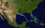
The 1942 Atlantic hurricane season officially began on June 16, 1942, and lasted until October 31, 1942. These dates conventionally delimit the period of each year when most tropical cyclone
s form in the Atlantic basin
.
The 1942 season
was near average. A few storms of note were two Category 1
storms striking north and central Texas and a Category 2 hitting Belize
. Most of the rest of the season's storms stayed out to sea. Only 1 major hurricane formed during the season and the only other landfall was a weak tropical storm that struck the Outer Banks
as a tropical depression.
. It tracked northwestward, where it slowly intensified to a minimal hurricane. The hurricane made landfall on the eastern Texas
coast on August 21 at Crystal Beach
near the entrance to Galveston Bay
, and dissipated two days later over extreme southern Missouri
. The hurricane caused around $600,000 in damage.
. This tropical storm moved westward over the Caribbean Sea
, strengthening to a hurricane on August 25 south of Jamaica
. The hurricane crossed over the northeast tip of the Yucatán Peninsula on August 28. While over the Gulf of Mexico
, the hurricane peaked with winds of 100 knots (54.4 m/s); it made landfall near Palacios, Texas
, as an intense hurricane.
The next day it dissipated over northwestern Texas, after resulting in $26.5 million in damage and eight casualties. The dissipating tropical storm brought extensive heavy rain well into New Mexico. River floods resulted downstream in Oklahoma in early September.
on August 25 heading northwest. It passed Bermuda to the east, strengthening to a Category 2 storm as it did so, recurving to the northeast. It continued to gain intensity and peaked just below major hurricane status with winds of 110 mi/h. It weakened as it reached cooler waters, dropping below hurricane strength at 39N latitude and looping back south and then west before dissipating on September 2.
in mid September and moved on a steady west-northwest track, not strengthening much. Its winds never rose above 50 mi/h. Storm Four turned more to the west after it passed south of Jamaica
and struck northern Belize
as a weakening tropical storm. It dissipated shortly thereafter.
on September 22.
on the first day of October and headed due northeast for almost its entire lifespan. It passed just to the southeast of Bermuda (an oft-visited island this season) and reached its peak intensity of 60 mi/h shortly thereafter. It became extratropical on October 4 as it approached 40N.
several hundred miles west-southwest of Bermuda on October 10. It curved gently west-northwestward and then northwestward toward the North Carolina's Outer Banks
, making landfall near Cape Lookout
shortly after weakening to a tropical depression two days following formation. It dissipated later that day. Eastern North Carolina
suffered heavy rainfall, but little, if any, damage resulted.
and the Bahamas before shifting to the northeast for the remainder of its lifetime, parallelling the eastern seaboard of the United States but remaining well offshore. It lost its identity near Sable Island
, Nova Scotia
. No damaging effects were reported from any of the affected islands.
later that day. After weakening over the island, the now tropical storm re-strengthened to a hurricane on November 8 over the western Caribbean Sea. It attained a peak of 95 mi/h winds before hitting Belize
on November 9. After crossing the Yucatán Peninsula, the ridge of high pressure built to its northwest, forcing the storm back southeastward. It hit the western Yucatán Peninsula on November 11, and dissipated shortly thereafter over land. The hurricane was responsible for nine deaths, $4 million in damage, and unavailable damage figures elsewhere. It has been detected in sediment cores from the bottom of the Great Blue Hole
.
Tropical cyclone
A tropical cyclone is a storm system characterized by a large low-pressure center and numerous thunderstorms that produce strong winds and heavy rain. Tropical cyclones strengthen when water evaporated from the ocean is released as the saturated air rises, resulting in condensation of water vapor...
s form in the Atlantic basin
Atlantic Basin
The Atlantic Basin is the Atlantic Ocean.Atlantic Basin may also refer to:* Atlantic Basin Iron Works, an ironworks that operated in Brooklyn, New York, in the early to mid-20th century...
.
The 1942 season
Atlantic hurricane season
The Atlantic hurricane season is the period in a year when hurricanes usually form in the Atlantic Ocean. Tropical cyclones in the North Atlantic are called hurricanes, tropical storms, or tropical depressions. In addition, there have been several storms over the years that have not been fully...
was near average. A few storms of note were two Category 1
Saffir-Simpson Hurricane Scale
The Saffir–Simpson Hurricane Scale , or the Saffir–Simpson Hurricane Wind Scale , classifies hurricanes — Western Hemisphere tropical cyclones that exceed the intensities of tropical depressions and tropical storms — into five categories distinguished by the intensities of their sustained winds...
storms striking north and central Texas and a Category 2 hitting Belize
Belize
Belize is a constitutional monarchy and the northernmost country in Central America. Belize has a diverse society, comprising many cultures and languages. Even though Kriol and Spanish are spoken among the population, Belize is the only country in Central America where English is the official...
. Most of the rest of the season's storms stayed out to sea. Only 1 major hurricane formed during the season and the only other landfall was a weak tropical storm that struck the Outer Banks
Outer Banks
The Outer Banks is a 200-mile long string of narrow barrier islands off the coast of North Carolina, beginning in the southeastern corner of Virginia Beach on the east coast of the United States....
as a tropical depression.
Hurricane One
A tropical storm was first observed on August 17 near the Yucatán PeninsulaYucatán Peninsula
The Yucatán Peninsula, in southeastern Mexico, separates the Caribbean Sea from the Gulf of Mexico, with the northern coastline on the Yucatán Channel...
. It tracked northwestward, where it slowly intensified to a minimal hurricane. The hurricane made landfall on the eastern Texas
Texas
Texas is the second largest U.S. state by both area and population, and the largest state by area in the contiguous United States.The name, based on the Caddo word "Tejas" meaning "friends" or "allies", was applied by the Spanish to the Caddo themselves and to the region of their settlement in...
coast on August 21 at Crystal Beach
Crystal Beach, Texas
Crystal Beach is an unincorporated area in the Bolivar Peninsula census-designated place, in Galveston County, Texas, United States. Also known as Patton, Crystal Beach stretches 7 miles along Texas State Highway 87 in the middle of Bolivar Peninsula.It is located along 27 miles of beach on...
near the entrance to Galveston Bay
Galveston Bay
Galveston Bay is a large estuary located along the upper coast of Texas in the United States. It is connected to the Gulf of Mexico and is surrounded by sub-tropic marshes and prairies on the mainland. The water in the Bay is a complex mixture of sea water and fresh water which supports a wide...
, and dissipated two days later over extreme southern Missouri
Missouri
Missouri is a US state located in the Midwestern United States, bordered by Iowa, Illinois, Kentucky, Tennessee, Arkansas, Oklahoma, Kansas and Nebraska. With a 2010 population of 5,988,927, Missouri is the 18th most populous state in the nation and the fifth most populous in the Midwest. It...
. The hurricane caused around $600,000 in damage.
Hurricane Two
The precursor to Hurricane Two, a tropical wave, developed into a tropical storm on August 21 over the Windward IslandsWindward Islands
The Windward Islands are the southern islands of the Lesser Antilles, within the West Indies.-Name and geography:The Windward Islands are called such because they were more windward to sailing ships arriving in the New World than the Leeward Islands, given that the prevailing trade winds in the...
. This tropical storm moved westward over the Caribbean Sea
Caribbean Sea
The Caribbean Sea is a sea of the Atlantic Ocean located in the tropics of the Western hemisphere. It is bounded by Mexico and Central America to the west and southwest, to the north by the Greater Antilles, and to the east by the Lesser Antilles....
, strengthening to a hurricane on August 25 south of Jamaica
Jamaica
Jamaica is an island nation of the Greater Antilles, in length, up to in width and 10,990 square kilometres in area. It is situated in the Caribbean Sea, about south of Cuba, and west of Hispaniola, the island harbouring the nation-states Haiti and the Dominican Republic...
. The hurricane crossed over the northeast tip of the Yucatán Peninsula on August 28. While over the Gulf of Mexico
Gulf of Mexico
The Gulf of Mexico is a partially landlocked ocean basin largely surrounded by the North American continent and the island of Cuba. It is bounded on the northeast, north and northwest by the Gulf Coast of the United States, on the southwest and south by Mexico, and on the southeast by Cuba. In...
, the hurricane peaked with winds of 100 knots (54.4 m/s); it made landfall near Palacios, Texas
Palacios, Texas
-Demographics:As of the census of 2000, there were 5,153 people, 1,661 households, and 1,244 families residing in the city. The population density was 1,021.4 people per square mile . There were 1,976 housing units at an average density of 391.7 per square mile...
, as an intense hurricane.
The next day it dissipated over northwestern Texas, after resulting in $26.5 million in damage and eight casualties. The dissipating tropical storm brought extensive heavy rain well into New Mexico. River floods resulted downstream in Oklahoma in early September.
Hurricane Three
The third storm of the season was first detected as a minimal hurricane southeast of BermudaBermuda
Bermuda is a British overseas territory in the North Atlantic Ocean. Located off the east coast of the United States, its nearest landmass is Cape Hatteras, North Carolina, about to the west-northwest. It is about south of Halifax, Nova Scotia, Canada, and northeast of Miami, Florida...
on August 25 heading northwest. It passed Bermuda to the east, strengthening to a Category 2 storm as it did so, recurving to the northeast. It continued to gain intensity and peaked just below major hurricane status with winds of 110 mi/h. It weakened as it reached cooler waters, dropping below hurricane strength at 39N latitude and looping back south and then west before dissipating on September 2.
Tropical Storm Four
A Caribbean storm, Storm Four formed roughly 100 miles (160.9 km) northeast of BarbadosBarbados
Barbados is an island country in the Lesser Antilles. It is in length and as much as in width, amounting to . It is situated in the western area of the North Atlantic and 100 kilometres east of the Windward Islands and the Caribbean Sea; therein, it is about east of the islands of Saint...
in mid September and moved on a steady west-northwest track, not strengthening much. Its winds never rose above 50 mi/h. Storm Four turned more to the west after it passed south of Jamaica
Jamaica
Jamaica is an island nation of the Greater Antilles, in length, up to in width and 10,990 square kilometres in area. It is situated in the Caribbean Sea, about south of Cuba, and west of Hispaniola, the island harbouring the nation-states Haiti and the Dominican Republic...
and struck northern Belize
Belize
Belize is a constitutional monarchy and the northernmost country in Central America. Belize has a diverse society, comprising many cultures and languages. Even though Kriol and Spanish are spoken among the population, Belize is the only country in Central America where English is the official...
as a weakening tropical storm. It dissipated shortly thereafter.
Tropical Storm Five
The fifth storm of the season was short-lived. It formed not far southwest of Bermuda on September 18 and moved generally northward for the next four days. Its winds peaked at 50 mi/h before becoming extratropicalExtratropical cyclone
Extratropical cyclones, sometimes called mid-latitude cyclones or wave cyclones, are a group of cyclones defined as synoptic scale low pressure weather systems that occur in the middle latitudes of the Earth having neither tropical nor polar characteristics, and are connected with fronts and...
on September 22.
Tropical Storm Six
Another weak Bermuda storm, Storm Six formed several hundred miles southeast of that island in late September and ended up making a horseshoe-like track around it, never coming within 100 miles (160.9 km) and passing to Bermuda's west. Winds topped out at 50 mi/h. It dissipated some 300 miles (482.8 km) north of the island in cooler waters on September 30.Tropical Storm Seven
Storm Seven formed near the Turks and Caicos IslandsTurks and Caicos Islands
The Turks and Caicos Islands are a British Overseas Territory and overseas territory of the European Union consisting of two groups of tropical islands in the Caribbean, the larger Caicos Islands and the smaller Turks Islands, known for tourism and as an offshore financial centre.The Turks and...
on the first day of October and headed due northeast for almost its entire lifespan. It passed just to the southeast of Bermuda (an oft-visited island this season) and reached its peak intensity of 60 mi/h shortly thereafter. It became extratropical on October 4 as it approached 40N.
Tropical Storm Eight
The season's eighth storm was a very weak system that formed in the open waters of the Sargasso SeaSargasso Sea
The Sargasso Sea is a region in the middle of the North Atlantic Ocean, surrounded by ocean currents. It is bounded on the west by the Gulf Stream; on the north, by the North Atlantic Current; on the east, by the Canary Current; and on the south, by the North Atlantic Equatorial Current. This...
several hundred miles west-southwest of Bermuda on October 10. It curved gently west-northwestward and then northwestward toward the North Carolina's Outer Banks
Outer Banks
The Outer Banks is a 200-mile long string of narrow barrier islands off the coast of North Carolina, beginning in the southeastern corner of Virginia Beach on the east coast of the United States....
, making landfall near Cape Lookout
Cape Lookout (North Carolina)
This article is about the Cape Lookout in North Carolina. See Cape Lookout for other places with a similar name. Cape Lookout is southern point of the Core Banks, one of the natural barrier islands on the Atlantic coast of North Carolina, USA. delimits Onslow Bay to the west from Raleigh Bay to...
shortly after weakening to a tropical depression two days following formation. It dissipated later that day. Eastern North Carolina
North Carolina
North Carolina is a state located in the southeastern United States. The state borders South Carolina and Georgia to the south, Tennessee to the west and Virginia to the north. North Carolina contains 100 counties. Its capital is Raleigh, and its largest city is Charlotte...
suffered heavy rainfall, but little, if any, damage resulted.
Tropical Storm Nine
Storm Nine formed near Jamaica on October 13 and moved due north through southern CubaCuba
The Republic of Cuba is an island nation in the Caribbean. The nation of Cuba consists of the main island of Cuba, the Isla de la Juventud, and several archipelagos. Havana is the largest city in Cuba and the country's capital. Santiago de Cuba is the second largest city...
and the Bahamas before shifting to the northeast for the remainder of its lifetime, parallelling the eastern seaboard of the United States but remaining well offshore. It lost its identity near Sable Island
Sable Island
Sable Island is a small Canadian island situated 300 km southeast of mainland Nova Scotia in the Atlantic Ocean. The island is a year-round home to approximately five people...
, Nova Scotia
Nova Scotia
Nova Scotia is one of Canada's three Maritime provinces and is the most populous province in Atlantic Canada. The name of the province is Latin for "New Scotland," but "Nova Scotia" is the recognized, English-language name of the province. The provincial capital is Halifax. Nova Scotia is the...
. No damaging effects were reported from any of the affected islands.
Hurricane Ten
On November 5, a tropical storm was first seen over the northern Lesser Antilles. It headed west-northwestward, becoming a hurricane on November 6 over the southern Bahamas. A ridge of high pressure to its north forced the storm west-southwestward, where it hit CubaCuba
The Republic of Cuba is an island nation in the Caribbean. The nation of Cuba consists of the main island of Cuba, the Isla de la Juventud, and several archipelagos. Havana is the largest city in Cuba and the country's capital. Santiago de Cuba is the second largest city...
later that day. After weakening over the island, the now tropical storm re-strengthened to a hurricane on November 8 over the western Caribbean Sea. It attained a peak of 95 mi/h winds before hitting Belize
Belize
Belize is a constitutional monarchy and the northernmost country in Central America. Belize has a diverse society, comprising many cultures and languages. Even though Kriol and Spanish are spoken among the population, Belize is the only country in Central America where English is the official...
on November 9. After crossing the Yucatán Peninsula, the ridge of high pressure built to its northwest, forcing the storm back southeastward. It hit the western Yucatán Peninsula on November 11, and dissipated shortly thereafter over land. The hurricane was responsible for nine deaths, $4 million in damage, and unavailable damage figures elsewhere. It has been detected in sediment cores from the bottom of the Great Blue Hole
Great Blue Hole
The Great Blue Hole is a large submarine sinkhole off the coast of Belize. It lies near the center of Lighthouse Reef, a small atoll from the mainland and Belize City. The hole is circular in shape, over across and deep...
.
See also
- List of tropical cyclones
- List of Atlantic hurricane seasons