
1929 Florida Hurricane
Encyclopedia
The 1929 Bahamas Hurricane (also known as the Great Andros Island Hurricane) was the second hurricane and the only major hurricane during the very inactive 1929 Atlantic hurricane season
. The hurricane was the only hurricane to cause any significant damage, resulting in $676,000 (1929 USD
, $7.3 million 2005 USD) in damage. Only a year after the 1928 Okeechobee Hurricane
, the hurricane caused only three deaths in southern Florida, a low number due to well-executed warnings. The hurricane was much more severe in the Bahamas, where damage was near extreme due to the hurricane stalling over the area for an extended period of time. There, the hurricane caused 48 deaths.
moved off the coast of Africa
on September 11. It moved across the Atlantic Ocean
and passed the northern Leeward Islands
before being detected as a tropical storm on the 22nd. The storm then moved westward and became a Category 1
hurricane on September 23. It continued to intensify, becoming a Category 3
hurricane on September 24 as it passed through the northern Bahamas. Due to higher pressures to the north, the hurricane drifted to the southwest, causing the hurricane to strike near Nassau
on the 26th as it reached its peak of 155 mph (250 km/h).
While drifting westward through the Bahamas, the hurricane weakened, and struck extreme southern Florida
as a Category 3
hurricane on September 28. The hurricane turned to the northwest, and continued to weaken until making landfall in the Florida Panhandle
as a tropical storm on the September 30. The storm turned to the northeast, and became extratropical over South Carolina
on October 2. The extratropical storm persisted for two more days, moving through the eastern United States before losing its identity over eastern New Brunswick
.
, weather officials issued hurricane warnings in the Bahamas and south Florida
. On September 24, hurricane warnings were issued for the Bahamas and areas from Florida
to South Carolina
, on the 25th, the warnings was extended to the Florida Keys
as the storm turned to the southwest. More warnings were issued hours before the hurricane made landfall in south Florida
. Weather officials also issued warnings for the Florida Panhandle
before the storm made landfall as a tropical storm.
In Florida
, the American Red Cross
and local officials in South Florida took precautions while residents evacuated low lying areas in the Everglades
.
, a sharp contrast to the Okeechobee Hurricane a year earlier; by contrast, however, damage was very severe in the Bahamas. In Cuba
, the hurricane brought rough seas and dark cloud cover.
recorded an unofficial pressure reading of 938 mbar
(27.64 inHg). The weather station also recorded a wind gust of 164 mph (264 km/h). According to the Associated Press
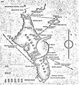
, the hurricane's 12 ft (3.7 meters) storm surge flooded a road and damaged a seawall, while property damage was severe. In Fresh Creek, the hurricane destroyed six houses and damaged ten others. It also damaged a communications station, disrupting telegraph service. Ten deaths were reported on Andros Island
, and according to press reports, 24 people were declared missing. Elsewhere in the Bahamas, the hurricane damaged or destroyed 63 homes and buildings brought flash flooding that left Andros Island under 20 ft (6 meters) of water. Offshore, a steamship was run aground near Abaco Island
, while a tanker broke in two near Andros Island. Eight sailors perished when their 18-foot schooner sank during the storm. In Fresh Creek, four small boats sank near the Andros Lighthouse, drowning more than 20 sailors.
Lord Baden-Powell arrived in the Bahamas at the Prince George Wharf in February 1930. On that occasion, Gordon O'Brien was presented with the Bronze Cross (the highest award for gallantry in Scouting) for his part in rescuing twelve women and children from a ship in distress during the hurricane of September, 1929.
and a barometric pressure reading of 989 mbar (29.21 inHg) was recorded in Key West
, and a reading of 954 mbar (28.18 inHg) was recorded at Long Key. Damage in the Florida Keys
was limited to swamped fishing boats and temporary loss in electricity and communications. Exact damage figures in the Florida Keys
are unavailable.
In Miami
, a reading of 998 mbar (29.41 inHg) reading was recorded as the hurricane made landfall, and wind speeds between 90 and 100 mph (150 to 157 km/h) were recorded in Everglades City. The hurricane spawned three tornadoes that touched down in Fort Lauderdale
, Miami
, and two other towns, with the Fort Lauderdale tornado being most destructive. The tornado damaged a four story hotel, a railway office building and several cottages before dissipating 30 minutes after its formation. In southwestern Florida, there was damage to orange and grapefruit crops. Three people were killed after ignoring warnings and trying to ride out the storm.
Damage in the Florida Panhandle
was moderate. The storm surge
destroyed several wharves and damaged most of the oyster and fishing warehouses and canning plants. The storm tide also damaged part of the Gulf Coast Highway, and left minimal damage to trees, homes and businesses. Throughout Florida, the hurricane caused 3 deaths and $676,000 in damage.
reported a barometric pressure reading of 29.12 inches (994 mbar). However, there were few reports of damage and no reports of deaths when the extratropical remnants of the hurricane traveled up the East Coast of the United States
. In Maine
, heavy rains up to 2 inches (7 mm) flooded storm cellars and broke a prolonged dry spell in the state, though damage was minimal.
which was shortly rebuilt after the storm. Offshore, the wreckage of a steamship that sank during the storm was blown up because it was a hazard to shipping. In Florida
, the damage from the hurricane knocked out rail service for a week. The United States Coast Guard
provided mail service to Key West
, an area hit hard by the hurricane.
1929 Atlantic hurricane season
The 1929 Atlantic hurricane season ran through the summer and the first half of fall in 1929. It was a mostly quiet season in the Atlantic as only five tropical cyclones formed during the season, with the distance between the first and second storms being nearly three months...
. The hurricane was the only hurricane to cause any significant damage, resulting in $676,000 (1929 USD
United States dollar
The United States dollar , also referred to as the American dollar, is the official currency of the United States of America. It is divided into 100 smaller units called cents or pennies....
, $7.3 million 2005 USD) in damage. Only a year after the 1928 Okeechobee Hurricane
1928 Okeechobee Hurricane
The Okeechobee hurricane, or San Felipe Segundo hurricane, was a deadly hurricane that struck the Leeward Islands, Puerto Rico, the Bahamas, and Florida in September of the 1928 Atlantic hurricane season...
, the hurricane caused only three deaths in southern Florida, a low number due to well-executed warnings. The hurricane was much more severe in the Bahamas, where damage was near extreme due to the hurricane stalling over the area for an extended period of time. There, the hurricane caused 48 deaths.
Meteorological history
A tropical waveTropical wave
Tropical waves, easterly waves, or tropical easterly waves, also known as African easterly waves in the Atlantic region, are a type of atmospheric trough, an elongated area of relatively low air pressure, oriented north to south, which move from east to west across the tropics causing areas of...
moved off the coast of Africa
Africa
Africa is the world's second largest and second most populous continent, after Asia. At about 30.2 million km² including adjacent islands, it covers 6% of the Earth's total surface area and 20.4% of the total land area...
on September 11. It moved across the Atlantic Ocean
Atlantic Ocean
The Atlantic Ocean is the second-largest of the world's oceanic divisions. With a total area of about , it covers approximately 20% of the Earth's surface and about 26% of its water surface area...
and passed the northern Leeward Islands
Leeward Islands
The Leeward Islands are a group of islands in the West Indies. They are the northern islands of the Lesser Antilles chain. As a group they start east of Puerto Rico and reach southward to Dominica. They are situated where the northeastern Caribbean Sea meets the western Atlantic Ocean...
before being detected as a tropical storm on the 22nd. The storm then moved westward and became a Category 1
Saffir-Simpson Hurricane Scale
The Saffir–Simpson Hurricane Scale , or the Saffir–Simpson Hurricane Wind Scale , classifies hurricanes — Western Hemisphere tropical cyclones that exceed the intensities of tropical depressions and tropical storms — into five categories distinguished by the intensities of their sustained winds...
hurricane on September 23. It continued to intensify, becoming a Category 3
Saffir-Simpson Hurricane Scale
The Saffir–Simpson Hurricane Scale , or the Saffir–Simpson Hurricane Wind Scale , classifies hurricanes — Western Hemisphere tropical cyclones that exceed the intensities of tropical depressions and tropical storms — into five categories distinguished by the intensities of their sustained winds...
hurricane on September 24 as it passed through the northern Bahamas. Due to higher pressures to the north, the hurricane drifted to the southwest, causing the hurricane to strike near Nassau
Nassau, Bahamas
Nassau is the capital, largest city, and commercial centre of the Commonwealth of the Bahamas. The city has a population of 248,948 , 70 percent of the entire population of The Bahamas...
on the 26th as it reached its peak of 155 mph (250 km/h).
While drifting westward through the Bahamas, the hurricane weakened, and struck extreme southern Florida
Florida
Florida is a state in the southeastern United States, located on the nation's Atlantic and Gulf coasts. It is bordered to the west by the Gulf of Mexico, to the north by Alabama and Georgia and to the east by the Atlantic Ocean. With a population of 18,801,310 as measured by the 2010 census, it...
as a Category 3
Saffir-Simpson Hurricane Scale
The Saffir–Simpson Hurricane Scale , or the Saffir–Simpson Hurricane Wind Scale , classifies hurricanes — Western Hemisphere tropical cyclones that exceed the intensities of tropical depressions and tropical storms — into five categories distinguished by the intensities of their sustained winds...
hurricane on September 28. The hurricane turned to the northwest, and continued to weaken until making landfall in the Florida Panhandle
Florida Panhandle
The Florida Panhandle, an informal, unofficial term for the northwestern part of Florida, is a strip of land roughly 200 miles long and 50 to 100 miles wide , lying between Alabama on the north and the west, Georgia also on the north, and the Gulf of Mexico to the south. Its eastern boundary is...
as a tropical storm on the September 30. The storm turned to the northeast, and became extratropical over South Carolina
South Carolina
South Carolina is a state in the Deep South of the United States that borders Georgia to the south, North Carolina to the north, and the Atlantic Ocean to the east. Originally part of the Province of Carolina, the Province of South Carolina was one of the 13 colonies that declared independence...
on October 2. The extratropical storm persisted for two more days, moving through the eastern United States before losing its identity over eastern New Brunswick
New Brunswick
New Brunswick is one of Canada's three Maritime provinces and is the only province in the federation that is constitutionally bilingual . The provincial capital is Fredericton and Saint John is the most populous city. Greater Moncton is the largest Census Metropolitan Area...
.
Preparations
Fearing a repeat of the 1928 Okeechobee Hurricane1928 Okeechobee Hurricane
The Okeechobee hurricane, or San Felipe Segundo hurricane, was a deadly hurricane that struck the Leeward Islands, Puerto Rico, the Bahamas, and Florida in September of the 1928 Atlantic hurricane season...
, weather officials issued hurricane warnings in the Bahamas and south Florida
Florida
Florida is a state in the southeastern United States, located on the nation's Atlantic and Gulf coasts. It is bordered to the west by the Gulf of Mexico, to the north by Alabama and Georgia and to the east by the Atlantic Ocean. With a population of 18,801,310 as measured by the 2010 census, it...
. On September 24, hurricane warnings were issued for the Bahamas and areas from Florida
Florida
Florida is a state in the southeastern United States, located on the nation's Atlantic and Gulf coasts. It is bordered to the west by the Gulf of Mexico, to the north by Alabama and Georgia and to the east by the Atlantic Ocean. With a population of 18,801,310 as measured by the 2010 census, it...
to South Carolina
South Carolina
South Carolina is a state in the Deep South of the United States that borders Georgia to the south, North Carolina to the north, and the Atlantic Ocean to the east. Originally part of the Province of Carolina, the Province of South Carolina was one of the 13 colonies that declared independence...
, on the 25th, the warnings was extended to the Florida Keys
Florida Keys
The Florida Keys are a coral archipelago in southeast United States. They begin at the southeastern tip of the Florida peninsula, about south of Miami, and extend in a gentle arc south-southwest and then westward to Key West, the westernmost of the inhabited islands, and on to the uninhabited Dry...
as the storm turned to the southwest. More warnings were issued hours before the hurricane made landfall in south Florida
Florida
Florida is a state in the southeastern United States, located on the nation's Atlantic and Gulf coasts. It is bordered to the west by the Gulf of Mexico, to the north by Alabama and Georgia and to the east by the Atlantic Ocean. With a population of 18,801,310 as measured by the 2010 census, it...
. Weather officials also issued warnings for the Florida Panhandle
Florida Panhandle
The Florida Panhandle, an informal, unofficial term for the northwestern part of Florida, is a strip of land roughly 200 miles long and 50 to 100 miles wide , lying between Alabama on the north and the west, Georgia also on the north, and the Gulf of Mexico to the south. Its eastern boundary is...
before the storm made landfall as a tropical storm.
In Florida
Florida
Florida is a state in the southeastern United States, located on the nation's Atlantic and Gulf coasts. It is bordered to the west by the Gulf of Mexico, to the north by Alabama and Georgia and to the east by the Atlantic Ocean. With a population of 18,801,310 as measured by the 2010 census, it...
, the American Red Cross
American Red Cross
The American Red Cross , also known as the American National Red Cross, is a volunteer-led, humanitarian organization that provides emergency assistance, disaster relief and education inside the United States. It is the designated U.S...
and local officials in South Florida took precautions while residents evacuated low lying areas in the Everglades
Everglades
The Everglades are subtropical wetlands in the southern portion of the U.S. state of Florida, comprising the southern half of a large watershed. The system begins near Orlando with the Kissimmee River, which discharges into the vast but shallow Lake Okeechobee...
.
Impact
Although a strong tropical cyclone, the hurricane caused little damage and only three deaths in FloridaFlorida
Florida is a state in the southeastern United States, located on the nation's Atlantic and Gulf coasts. It is bordered to the west by the Gulf of Mexico, to the north by Alabama and Georgia and to the east by the Atlantic Ocean. With a population of 18,801,310 as measured by the 2010 census, it...
, a sharp contrast to the Okeechobee Hurricane a year earlier; by contrast, however, damage was very severe in the Bahamas. In Cuba
Cuba
The Republic of Cuba is an island nation in the Caribbean. The nation of Cuba consists of the main island of Cuba, the Isla de la Juventud, and several archipelagos. Havana is the largest city in Cuba and the country's capital. Santiago de Cuba is the second largest city...
, the hurricane brought rough seas and dark cloud cover.
| Death Totals | |
| Country | Fatalities |
|---|---|
| Bahamas | 48 |
| United States United States The United States of America is a federal constitutional republic comprising fifty states and a federal district... |
3 |
| Total | 51 |
Bahamas
A weather station in NassauNassau, Bahamas
Nassau is the capital, largest city, and commercial centre of the Commonwealth of the Bahamas. The city has a population of 248,948 , 70 percent of the entire population of The Bahamas...
recorded an unofficial pressure reading of 938 mbar
(27.64 inHg). The weather station also recorded a wind gust of 164 mph (264 km/h). According to the Associated Press
Associated Press
The Associated Press is an American news agency. The AP is a cooperative owned by its contributing newspapers, radio and television stations in the United States, which both contribute stories to the AP and use material written by its staff journalists...
, the hurricane's 12 ft (3.7 meters) storm surge flooded a road and damaged a seawall, while property damage was severe. In Fresh Creek, the hurricane destroyed six houses and damaged ten others. It also damaged a communications station, disrupting telegraph service. Ten deaths were reported on Andros Island
Andros, Bahamas
Andros Island is an archipelago within the archipelago-nation of the Bahamas, the largest of the 26 inhabited Bahamian Islands. Geo-politically considered a single island, Andros has an area greater than all the other 700 Bahamian islands combined...
, and according to press reports, 24 people were declared missing. Elsewhere in the Bahamas, the hurricane damaged or destroyed 63 homes and buildings brought flash flooding that left Andros Island under 20 ft (6 meters) of water. Offshore, a steamship was run aground near Abaco Island
Abaco Islands
The Abaco Islands lie in the northern Bahamas and comprise the main islands of Great Abaco and Little Abaco, together with the smaller Wood Cay, Elbow Cay, Lubbers Quarters Cay, Green Turtle Cay, Great Guana Cay, Castaway Cay, Man-o-War Cay, Stranger's Cay, Umbrella Cay, Walker's Cay, Little Grand...
, while a tanker broke in two near Andros Island. Eight sailors perished when their 18-foot schooner sank during the storm. In Fresh Creek, four small boats sank near the Andros Lighthouse, drowning more than 20 sailors.
Lord Baden-Powell arrived in the Bahamas at the Prince George Wharf in February 1930. On that occasion, Gordon O'Brien was presented with the Bronze Cross (the highest award for gallantry in Scouting) for his part in rescuing twelve women and children from a ship in distress during the hurricane of September, 1929.
Florida
A 150 mph (235 km/h) wind gust was recorded near Key LargoKey Largo, Florida
Key Largo is a census-designated place in Monroe County, Florida, United States, located on the island of Key Largo in the upper Florida Keys. The population was 11,886 at the 2000 census. The name comes from the Spanish Cayo Largo, or "long key"...
and a barometric pressure reading of 989 mbar (29.21 inHg) was recorded in Key West
Key West, Florida
Key West is a city in Monroe County, Florida, United States. The city encompasses the island of Key West, the part of Stock Island north of U.S. 1 , Sigsbee Park , Fleming Key , and Sunset Key...
, and a reading of 954 mbar (28.18 inHg) was recorded at Long Key. Damage in the Florida Keys
Florida Keys
The Florida Keys are a coral archipelago in southeast United States. They begin at the southeastern tip of the Florida peninsula, about south of Miami, and extend in a gentle arc south-southwest and then westward to Key West, the westernmost of the inhabited islands, and on to the uninhabited Dry...
was limited to swamped fishing boats and temporary loss in electricity and communications. Exact damage figures in the Florida Keys
Florida Keys
The Florida Keys are a coral archipelago in southeast United States. They begin at the southeastern tip of the Florida peninsula, about south of Miami, and extend in a gentle arc south-southwest and then westward to Key West, the westernmost of the inhabited islands, and on to the uninhabited Dry...
are unavailable.
In Miami
Miami, Florida
Miami is a city located on the Atlantic coast in southeastern Florida and the county seat of Miami-Dade County, the most populous county in Florida and the eighth-most populous county in the United States with a population of 2,500,625...
, a reading of 998 mbar (29.41 inHg) reading was recorded as the hurricane made landfall, and wind speeds between 90 and 100 mph (150 to 157 km/h) were recorded in Everglades City. The hurricane spawned three tornadoes that touched down in Fort Lauderdale
Fort Lauderdale, Florida
Fort Lauderdale is a city in the U.S. state of Florida, on the Atlantic coast. It is the county seat of Broward County. As of the 2010 census, the city had a population of 165,521. It is a principal city of the South Florida metropolitan area, which was home to 5,564,635 people at the 2010...
, Miami
Miami, Florida
Miami is a city located on the Atlantic coast in southeastern Florida and the county seat of Miami-Dade County, the most populous county in Florida and the eighth-most populous county in the United States with a population of 2,500,625...
, and two other towns, with the Fort Lauderdale tornado being most destructive. The tornado damaged a four story hotel, a railway office building and several cottages before dissipating 30 minutes after its formation. In southwestern Florida, there was damage to orange and grapefruit crops. Three people were killed after ignoring warnings and trying to ride out the storm.
Damage in the Florida Panhandle
Florida Panhandle
The Florida Panhandle, an informal, unofficial term for the northwestern part of Florida, is a strip of land roughly 200 miles long and 50 to 100 miles wide , lying between Alabama on the north and the west, Georgia also on the north, and the Gulf of Mexico to the south. Its eastern boundary is...
was moderate. The storm surge
Storm surge
A storm surge is an offshore rise of water associated with a low pressure weather system, typically tropical cyclones and strong extratropical cyclones. Storm surges are caused primarily by high winds pushing on the ocean's surface. The wind causes the water to pile up higher than the ordinary sea...
destroyed several wharves and damaged most of the oyster and fishing warehouses and canning plants. The storm tide also damaged part of the Gulf Coast Highway, and left minimal damage to trees, homes and businesses. Throughout Florida, the hurricane caused 3 deaths and $676,000 in damage.
Eastern U.S.
A weather station in GeorgiaGeorgia (U.S. state)
Georgia is a state located in the southeastern United States. It was established in 1732, the last of the original Thirteen Colonies. The state is named after King George II of Great Britain. Georgia was the fourth state to ratify the United States Constitution, on January 2, 1788...
reported a barometric pressure reading of 29.12 inches (994 mbar). However, there were few reports of damage and no reports of deaths when the extratropical remnants of the hurricane traveled up the East Coast of the United States
East Coast of the United States
The East Coast of the United States, also known as the Eastern Seaboard, refers to the easternmost coastal states in the United States, which touch the Atlantic Ocean and stretch up to Canada. The term includes the U.S...
. In Maine
Maine
Maine is a state in the New England region of the northeastern United States, bordered by the Atlantic Ocean to the east and south, New Hampshire to the west, and the Canadian provinces of Quebec to the northwest and New Brunswick to the northeast. Maine is both the northernmost and easternmost...
, heavy rains up to 2 inches (7 mm) flooded storm cellars and broke a prolonged dry spell in the state, though damage was minimal.
Aftermath
In the Bahamas, the hurricane destroyed the Ministry of Education mansion in NassauNassau, Bahamas
Nassau is the capital, largest city, and commercial centre of the Commonwealth of the Bahamas. The city has a population of 248,948 , 70 percent of the entire population of The Bahamas...
which was shortly rebuilt after the storm. Offshore, the wreckage of a steamship that sank during the storm was blown up because it was a hazard to shipping. In Florida
Florida
Florida is a state in the southeastern United States, located on the nation's Atlantic and Gulf coasts. It is bordered to the west by the Gulf of Mexico, to the north by Alabama and Georgia and to the east by the Atlantic Ocean. With a population of 18,801,310 as measured by the 2010 census, it...
, the damage from the hurricane knocked out rail service for a week. The United States Coast Guard
United States Coast Guard
The United States Coast Guard is a branch of the United States Armed Forces and one of the seven U.S. uniformed services. The Coast Guard is a maritime, military, multi-mission service unique among the military branches for having a maritime law enforcement mission and a federal regulatory agency...
provided mail service to Key West
Key West, Florida
Key West is a city in Monroe County, Florida, United States. The city encompasses the island of Key West, the part of Stock Island north of U.S. 1 , Sigsbee Park , Fleming Key , and Sunset Key...
, an area hit hard by the hurricane.