
1929 Atlantic hurricane season
Encyclopedia
The 1929 Atlantic hurricane season ran through the summer and the first half of fall in 1929. It was a mostly quiet season in the Atlantic as only five tropical cyclones formed during the season, with the distance between the first and second storms being nearly three months. Of the five storms that formed, three reached hurricane strength, and one became a major hurricane.
Most of the season's damage and fatalities was caused by the second hurricane of the season. It formed north-east of the Caribbean
, and hit the Bahamas as a Category 4. It killed 50 people in the Bahamas and caused damage in the Florida Keyes. Another storm hit central Texas
as a Category 1
, causing light damage. The other one stayed out to sea.
. Moving northward, the developing storm strengthened to a hurricane on June 28 while turning northwest. Continuing to move northwest and intensify, the hurricane reached its peak of 90 miles per hour (144.8 km/h) later on June 28, and made landfall shortly afterward near Matagorda Bay
as that intensity, a strong Category 1 hurricane
, late on June 28. The hurricane weakened quickly to a tropical storm after moving inland on June 29, and remained at that intensity through New Mexico. It eventually dissipated on June 30 over Arizona. Damage was light.
, roofs were torn off houses, debris
was thrown through the air, and small craft were sunk in the harbors. It grazed the southwest coast and struck again at the Big Bend
area as a strong tropical storm. The storm dissipated inland. It killed nearly 50 people in the Bahamas and caused catastrophic damage on Andros Island where it hit as a strong Category 4 hurricane.
. It moved west-southwestward before turning to the northwest, becoming extratropical on October 19.
Most of the season's damage and fatalities was caused by the second hurricane of the season. It formed north-east of the Caribbean
Caribbean
The Caribbean is a crescent-shaped group of islands more than 2,000 miles long separating the Gulf of Mexico and the Caribbean Sea, to the west and south, from the Atlantic Ocean, to the east and north...
, and hit the Bahamas as a Category 4. It killed 50 people in the Bahamas and caused damage in the Florida Keyes. Another storm hit central Texas
Texas
Texas is the second largest U.S. state by both area and population, and the largest state by area in the contiguous United States.The name, based on the Caddo word "Tejas" meaning "friends" or "allies", was applied by the Spanish to the Caddo themselves and to the region of their settlement in...
as a Category 1
Saffir-Simpson Hurricane Scale
The Saffir–Simpson Hurricane Scale , or the Saffir–Simpson Hurricane Wind Scale , classifies hurricanes — Western Hemisphere tropical cyclones that exceed the intensities of tropical depressions and tropical storms — into five categories distinguished by the intensities of their sustained winds...
, causing light damage. The other one stayed out to sea.
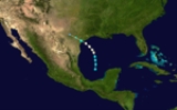
Hurricane One
A 40 miles per hour (64.4 km/h) tropical storm formed on June 27 in the central Bay of CampecheBay of Campeche
The Bay of Campeche is the southern bight of the Gulf of Mexico. It is surrounded on three sides by the Mexican states of Campeche, Tabasco and Veracruz. It was named by Francisco Hernández de Córdoba and Antonio de Alaminos during their expedition in 1517...
. Moving northward, the developing storm strengthened to a hurricane on June 28 while turning northwest. Continuing to move northwest and intensify, the hurricane reached its peak of 90 miles per hour (144.8 km/h) later on June 28, and made landfall shortly afterward near Matagorda Bay
Matagorda Bay
Matagorda Bay is a large estuary bay on the Texas coast, lying in Calhoun and Matagorda counties and located approximately northeast of Corpus Christi, southeast of San Antonio, southwest of Houston, and southeast of Austin. It is separated from the Gulf of Mexico by Matagorda Peninsula and...
as that intensity, a strong Category 1 hurricane
Saffir-Simpson Hurricane Scale
The Saffir–Simpson Hurricane Scale , or the Saffir–Simpson Hurricane Wind Scale , classifies hurricanes — Western Hemisphere tropical cyclones that exceed the intensities of tropical depressions and tropical storms — into five categories distinguished by the intensities of their sustained winds...
, late on June 28. The hurricane weakened quickly to a tropical storm after moving inland on June 29, and remained at that intensity through New Mexico. It eventually dissipated on June 30 over Arizona. Damage was light.
Hurricane Two
Of this season's 5 storms, the 1929 Florida Hurricane (or the Great Andros Island hurricane) was the most notable. In the KeysFlorida Keys
The Florida Keys are a coral archipelago in southeast United States. They begin at the southeastern tip of the Florida peninsula, about south of Miami, and extend in a gentle arc south-southwest and then westward to Key West, the westernmost of the inhabited islands, and on to the uninhabited Dry...
, roofs were torn off houses, debris
Debris
Debris is rubble, wreckage, ruins, litter and discarded garbage/refuse/trash, scattered remains of something destroyed, or, in geology, large rock fragments left by a melting glacier etc. The singular form of debris is debris...
was thrown through the air, and small craft were sunk in the harbors. It grazed the southwest coast and struck again at the Big Bend
Big Bend (Florida)
The Big Bend of Florida, U.S.A., is an informal region of the state with no official surveyed boundary. It includes part of the counties of the Florida Panhandle. Geologists prefer to characterize Florida’s Big Bend as the drowned karst section of the coast that occurs between the mouth of the...
area as a strong tropical storm. The storm dissipated inland. It killed nearly 50 people in the Bahamas and caused catastrophic damage on Andros Island where it hit as a strong Category 4 hurricane.
Tropical Storm Three
A tropical storm formed on September 25 west of Bermuda. It curved northward, becoming extratropical on September 27, and dissipating on September 29.Tropical Storm Four
A tropical storm formed on October 15 in the eastern North Atlantic south-southwest of the AzoresAzores
The Archipelago of the Azores is composed of nine volcanic islands situated in the middle of the North Atlantic Ocean, and is located about west from Lisbon and about east from the east coast of North America. The islands, and their economic exclusion zone, form the Autonomous Region of the...
. It moved west-southwestward before turning to the northwest, becoming extratropical on October 19.
Hurricane Five
Originally considered a continuation of the previous storm, the final storm of the season formed on October 19. It moved northeastward, becoming a hurricane and reaching peak winds of 80 miles per hour (128.7 km/h). The hurricane turned to the northwest, becoming extratropical on October 22 and dissipating the next day.See also
- List of tropical cyclones
- List of Atlantic hurricane seasons