
1927 Atlantic hurricane season
Encyclopedia
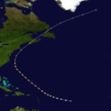
The 1927 Atlantic hurricane season ran through the summer and the first half of fall in 1927. The season was relatively inactive. There were eight tropical cyclones that formed during the season; four became hurricanes; one became a major hurricane. The first storm of the season was also the strongest and most notable. It became a Category 3 early in its life and was one for a long time (more than two days). It then became a strong extratropical cyclone as it headed up the east coast of the U.S. striking Nova Scotia
causing heavy damage and 184 deaths. The other hurricane to affect land produced gusty winds on Bermuda
. The only cyclone to strike the U.S. that year was a tropical storm that made landfall in South Carolina
.
as a Category 2 hurricane with 105 mi/h sustained winds, raking all the way up through Newfoundland. The storm killed 184 people and caused over one million dollars in damages.
that spent its entire life over the open ocean. It formed off Dakar
in early September and moved nearly due west for an entire week with a slight northward grade. It became a hurricane on September 7 and reached peak winds of 90 mi/h. Shortly after reaching its peak intensity on September 9, it recurved to the north-northeast and became extratropical.
and the Windward Islands
. It moved northwestward in the direction Bermuda
and strengthened. It became a hurricane the day after forming. Storm Four reached peak winds of 110 mi/h as it recurved away from Bermuda, which briefly received gale-force winds. The storm slowly weakened over cooler waters and became extratropical on September 29 while just south of the Grand Banks
.
the next day and very slowly weakened inland. The storm recurved over the Carolinas and dissipated over northern Virginia. No damage was reported.
and turned northeastward into southeast Cuba with winds no higher than 45 mi/h. Heavy rains caused some crop damage but little else of consequence. The storm quickly exited Cuba and passed over the Bahamas before dissipating over the western Atlantic.
night with sustained winds of only 45 mi/h. It then passed through the Bahamas slight weaker and turned more northward. It became extratropical on November 3.
Nova Scotia
Nova Scotia is one of Canada's three Maritime provinces and is the most populous province in Atlantic Canada. The name of the province is Latin for "New Scotland," but "Nova Scotia" is the recognized, English-language name of the province. The provincial capital is Halifax. Nova Scotia is the...
causing heavy damage and 184 deaths. The other hurricane to affect land produced gusty winds on Bermuda
Bermuda
Bermuda is a British overseas territory in the North Atlantic Ocean. Located off the east coast of the United States, its nearest landmass is Cape Hatteras, North Carolina, about to the west-northwest. It is about south of Halifax, Nova Scotia, Canada, and northeast of Miami, Florida...
. The only cyclone to strike the U.S. that year was a tropical storm that made landfall in South Carolina
South Carolina
South Carolina is a state in the Deep South of the United States that borders Georgia to the south, North Carolina to the north, and the Atlantic Ocean to the east. Originally part of the Province of Carolina, the Province of South Carolina was one of the 13 colonies that declared independence...
.
Hurricane One
The first storm of the season was the most notable. It was the tropical inception of the Great August Gale that caused heavy damage to Atlantic Canada. It formed in the deep tropics in mid August and quickly strengthened into a hurricane, eventually attaining winds of 120 mi/h. The storm moved northwest toward the American mid-Atlantic coast. It was a major hurricane for two and a half days before becoming extratropical on August 24 and recurving to the northeast. It struck Yarmouth, Nova ScotiaYarmouth, Nova Scotia
Yarmouth is a town and fishing port located on the Gulf of Maine in rural southwestern Nova Scotia, Canada. It is the shire town of Yarmouth County. The town is located in the heart of the world's largest lobster fishing grounds and has Canada's highest lobster catch.- History :The townsite may...
as a Category 2 hurricane with 105 mi/h sustained winds, raking all the way up through Newfoundland. The storm killed 184 people and caused over one million dollars in damages.
Hurricane Two
Storm Two was a Cape Verde-type hurricaneCape Verde-type hurricane
A Cape Verde-type hurricane is an Atlantic hurricane that develops near the Cape Verde islands, off the west coast of Africa. The average hurricane season has about two Cape Verde-type hurricanes, which are usually the largest and most intense storms of the season because they often have plenty of...
that spent its entire life over the open ocean. It formed off Dakar
Dakar
Dakar is the capital city and largest city of Senegal. It is located on the Cap-Vert Peninsula on the Atlantic coast and is the westernmost city on the African mainland...
in early September and moved nearly due west for an entire week with a slight northward grade. It became a hurricane on September 7 and reached peak winds of 90 mi/h. Shortly after reaching its peak intensity on September 9, it recurved to the north-northeast and became extratropical.
Hurricane Three
The third hurricane of the season was very similar to 1998's Hurricane Lisa in that it moved nearly due north across the central Atlantic for most of its existence and was a tropical storm until the very end of its life. Storm Three moved slowly for the first five days while moving on a more northwesterly track. On September 28 it sped up and turned straight north. It became a hurricane the next day but would lose its identity that evening.Hurricane Four
The fourth storm of the season formed shortly after Storm Three in the same general area between Cape VerdeCape Verde
The Republic of Cape Verde is an island country, spanning an archipelago of 10 islands located in the central Atlantic Ocean, 570 kilometres off the coast of Western Africa...
and the Windward Islands
Windward Islands
The Windward Islands are the southern islands of the Lesser Antilles, within the West Indies.-Name and geography:The Windward Islands are called such because they were more windward to sailing ships arriving in the New World than the Leeward Islands, given that the prevailing trade winds in the...
. It moved northwestward in the direction Bermuda
Bermuda
Bermuda is a British overseas territory in the North Atlantic Ocean. Located off the east coast of the United States, its nearest landmass is Cape Hatteras, North Carolina, about to the west-northwest. It is about south of Halifax, Nova Scotia, Canada, and northeast of Miami, Florida...
and strengthened. It became a hurricane the day after forming. Storm Four reached peak winds of 110 mi/h as it recurved away from Bermuda, which briefly received gale-force winds. The storm slowly weakened over cooler waters and became extratropical on September 29 while just south of the Grand Banks
Grand Banks
The Grand Banks of Newfoundland are a group of underwater plateaus southeast of Newfoundland on the North American continental shelf. These areas are relatively shallow, ranging from in depth. The cold Labrador Current mixes with the warm waters of the Gulf Stream here.The mixing of these waters...
.
Tropical Storm Five
The only cyclone to strike the United States in 1927, Storm Five formed near the central Bahamas on the last day of September and moved generally northwest, reaching its peak intensity of 60 mi/h on the afternoon of October 2. It made landfall at that intensity near Beaufort, South CarolinaBeaufort, South Carolina
Beaufort is a city in and the county seat of Beaufort County, South Carolina, United States. Chartered in 1711, it is the second-oldest city in South Carolina, behind Charleston. The city's population was 12,361 in the 2010 census. It is located in the Hilton Head Island-Beaufort Micropolitan...
the next day and very slowly weakened inland. The storm recurved over the Carolinas and dissipated over northern Virginia. No damage was reported.
Tropical Storm Six
The sixth storm of the season formed in the western Caribbean on October 16 and moved due east, an odd track for Atlantic storms prior to recurvature. It clipped the Cayman IslandsCayman Islands
The Cayman Islands is a British Overseas Territory and overseas territory of the European Union located in the western Caribbean Sea. The territory comprises the three islands of Grand Cayman, Cayman Brac, and Little Cayman, located south of Cuba and northwest of Jamaica...
and turned northeastward into southeast Cuba with winds no higher than 45 mi/h. Heavy rains caused some crop damage but little else of consequence. The storm quickly exited Cuba and passed over the Bahamas before dissipating over the western Atlantic.
Tropical Storm Seven
The seventh storm of the season formed near the Cayman Islands in late October, moving up through central Cuba on HalloweenHalloween
Hallowe'en , also known as Halloween or All Hallows' Eve, is a yearly holiday observed around the world on October 31, the night before All Saints' Day...
night with sustained winds of only 45 mi/h. It then passed through the Bahamas slight weaker and turned more northward. It became extratropical on November 3.
Tropical Storm Eight
The final storm of the season formed far to the east-northeast of the Lesser Antilles. It moved north-northwestward, reaching peak winds of 60 mph (95 km/h), and became extratropical on November 21 well east of Bermuda.See also
- List of tropical cyclones
- List of Atlantic hurricane seasons