
1884 Atlantic hurricane season
Encyclopedia
The 1884 Atlantic hurricane season ran through the summer and the first half of fall in 1884. These dates conventionally delimit the period of each year when most tropical cyclone
s form in the Atlantic basin
. Due to inactivity of the season, there was no storms in June, July, early to mid-August and November. Tropical cyclones that did not approach populated areas or shipping lanes, especially if they were relatively weak and of short duration, may have remained undetected. Because technologies such as satellite monitoring
were not available until the 1960s, historical data on tropical cyclones from this period are often not reliable.
, except for Hurricane Four which formed in the Caribbean Sea
on October 7. Not one storm existed in the Gulf of Mexico
during the hurricane season. Only one storm did not affect land, which was Hurricane Two.
.
This storm was upgraded from a tropical storm into a hurricane during the HURDAT
Re-Analysis Project. The minimum pressure was found to be at least 997 mb.
. Moving west-northwestward, it reached hurricane strength on the 5th. Land masses were spared when the storm curved northeastward, where it became a Category 3 hurricane. Unfavorable conditions weakened it, and it dissipated over the northern Atlantic ocean on the 16th.
. It moved northwestward, hitting the coast of Georgia
the next day. It weakened over land, but did a U-turn and restrengthened over the Atlantic Ocean
. Moving southeastward, it reached favorable conditions, where, after looping, it became a hurricane on the 15th. The hurricane moved rapidly northeastward, passing Bermuda
to the south and becoming extratropical on the 20th.
on October 7. It moved north-northeastward, reaching hurricane strength on the 8th before hitting southeast Cuba
on the 9th. After passing Cuba, it weakened to a tropical storm, but restrengthened over the Bahamas to a Category 2 hurricane. It stalled on the 13th, followed by a turn to the east where it dissipated on the 17th. Eight people drowned in Jamaica during the storm's development stages.
Tropical cyclone
A tropical cyclone is a storm system characterized by a large low-pressure center and numerous thunderstorms that produce strong winds and heavy rain. Tropical cyclones strengthen when water evaporated from the ocean is released as the saturated air rises, resulting in condensation of water vapor...
s form in the Atlantic basin
Atlantic Basin
The Atlantic Basin is the Atlantic Ocean.Atlantic Basin may also refer to:* Atlantic Basin Iron Works, an ironworks that operated in Brooklyn, New York, in the early to mid-20th century...
. Due to inactivity of the season, there was no storms in June, July, early to mid-August and November. Tropical cyclones that did not approach populated areas or shipping lanes, especially if they were relatively weak and of short duration, may have remained undetected. Because technologies such as satellite monitoring
Satellite imagery
Satellite imagery consists of photographs of Earth or other planets made by means of artificial satellites.- History :The first images from space were taken on sub-orbital flights. The U.S-launched V-2 flight on October 24, 1946 took one image every 1.5 seconds...
were not available until the 1960s, historical data on tropical cyclones from this period are often not reliable.
Season summary
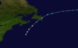
The 1884 Atlantic hurricane season was a very inactive one with activity being confined from September 1 to October 17, well inside the hurricane season. Only four storms formed, all reaching hurricane strength and only one reaching major hurricane status (Category 3+). All of the storms formed in the Atlantic OceanAtlantic Ocean
The Atlantic Ocean is the second-largest of the world's oceanic divisions. With a total area of about , it covers approximately 20% of the Earth's surface and about 26% of its water surface area...
, except for Hurricane Four which formed in the Caribbean Sea
Caribbean Sea
The Caribbean Sea is a sea of the Atlantic Ocean located in the tropics of the Western hemisphere. It is bounded by Mexico and Central America to the west and southwest, to the north by the Greater Antilles, and to the east by the Lesser Antilles....
on October 7. Not one storm existed in the Gulf of Mexico
Gulf of Mexico
The Gulf of Mexico is a partially landlocked ocean basin largely surrounded by the North American continent and the island of Cuba. It is bounded on the northeast, north and northwest by the Gulf Coast of the United States, on the southwest and south by Mexico, and on the southeast by Cuba. In...
during the hurricane season. Only one storm did not affect land, which was Hurricane Two.
Hurricane One
A tropical cyclone existed in late August over the western Atlantic, but it was not until September 1 that it was confirmed to exist. It moved to the northeast, reaching a peak of 80 mi/h winds before weakening. It hit Newfoundland on the 2nd as a strong tropical storm, and became extratropical the following day. The now extratropical storm moved and dissipated just short of PortugalPortugal
Portugal , officially the Portuguese Republic is a country situated in southwestern Europe on the Iberian Peninsula. Portugal is the westernmost country of Europe, and is bordered by the Atlantic Ocean to the West and South and by Spain to the North and East. The Atlantic archipelagos of the...
.
This storm was upgraded from a tropical storm into a hurricane during the HURDAT
HURDAT
The North Atlantic hurricane database, or HURDAT, is the database for all tropical cyclones in the Atlantic Ocean, Gulf of Mexico and Caribbean Sea, since 1851.-History:...
Re-Analysis Project. The minimum pressure was found to be at least 997 mb.
Hurricane Two
The second storm formed on September 3 and lasted until September 16. It formed over the tropical Atlantic and was a Cape Verde-type hurricaneCape Verde-type hurricane
A Cape Verde-type hurricane is an Atlantic hurricane that develops near the Cape Verde islands, off the west coast of Africa. The average hurricane season has about two Cape Verde-type hurricanes, which are usually the largest and most intense storms of the season because they often have plenty of...
. Moving west-northwestward, it reached hurricane strength on the 5th. Land masses were spared when the storm curved northeastward, where it became a Category 3 hurricane. Unfavorable conditions weakened it, and it dissipated over the northern Atlantic ocean on the 16th.
Hurricane Three
The third storm of the season formed on September 10 off the coast of FloridaFlorida
Florida is a state in the southeastern United States, located on the nation's Atlantic and Gulf coasts. It is bordered to the west by the Gulf of Mexico, to the north by Alabama and Georgia and to the east by the Atlantic Ocean. With a population of 18,801,310 as measured by the 2010 census, it...
. It moved northwestward, hitting the coast of Georgia
Georgia (U.S. state)
Georgia is a state located in the southeastern United States. It was established in 1732, the last of the original Thirteen Colonies. The state is named after King George II of Great Britain. Georgia was the fourth state to ratify the United States Constitution, on January 2, 1788...
the next day. It weakened over land, but did a U-turn and restrengthened over the Atlantic Ocean
Atlantic Ocean
The Atlantic Ocean is the second-largest of the world's oceanic divisions. With a total area of about , it covers approximately 20% of the Earth's surface and about 26% of its water surface area...
. Moving southeastward, it reached favorable conditions, where, after looping, it became a hurricane on the 15th. The hurricane moved rapidly northeastward, passing Bermuda
Bermuda
Bermuda is a British overseas territory in the North Atlantic Ocean. Located off the east coast of the United States, its nearest landmass is Cape Hatteras, North Carolina, about to the west-northwest. It is about south of Halifax, Nova Scotia, Canada, and northeast of Miami, Florida...
to the south and becoming extratropical on the 20th.
Hurricane Four
The fourth and final storm of the season began its life south of JamaicaJamaica
Jamaica is an island nation of the Greater Antilles, in length, up to in width and 10,990 square kilometres in area. It is situated in the Caribbean Sea, about south of Cuba, and west of Hispaniola, the island harbouring the nation-states Haiti and the Dominican Republic...
on October 7. It moved north-northeastward, reaching hurricane strength on the 8th before hitting southeast Cuba
Cuba
The Republic of Cuba is an island nation in the Caribbean. The nation of Cuba consists of the main island of Cuba, the Isla de la Juventud, and several archipelagos. Havana is the largest city in Cuba and the country's capital. Santiago de Cuba is the second largest city...
on the 9th. After passing Cuba, it weakened to a tropical storm, but restrengthened over the Bahamas to a Category 2 hurricane. It stalled on the 13th, followed by a turn to the east where it dissipated on the 17th. Eight people drowned in Jamaica during the storm's development stages.
See also
- List of tropical cyclones
- List of Atlantic hurricane seasons