

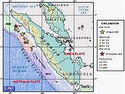
1861 Sumatra earthquake
Encyclopedia
Earthquake
An earthquake is the result of a sudden release of energy in the Earth's crust that creates seismic waves. The seismicity, seismism or seismic activity of an area refers to the frequency, type and size of earthquakes experienced over a period of time...
s that ruptured adjacent parts of the Sumatran segment of the Sunda megathrust
Sunda megathrust
The Sunda megathrust is a fault that extends approximately 5,500 km from Myanmar in the north, running along the southwestern side of Sumatra, to the south of Java and Bali before terminating near Australia...
. It caused a devastating tsunami
Tsunami
A tsunami is a series of water waves caused by the displacement of a large volume of a body of water, typically an ocean or a large lake...
which led to several thousand fatalities. The earthquake was felt as far away as the Malay peninsula and the eastern part of Java
Java
Java is an island of Indonesia. With a population of 135 million , it is the world's most populous island, and one of the most densely populated regions in the world. It is home to 60% of Indonesia's population. The Indonesian capital city, Jakarta, is in west Java...
. The rupture area for the 2005 Sumatra earthquake
2005 Sumatra earthquake
The 2005 Sumatra earthquake, referred to as the Nias Earthquake by the scientific community, was a major earthquake on 28 March 2005, located off the west coast of northern Sumatra, Indonesia. Approximately 1300 people were killed by the earthquake, mostly on the island of Nias...
is similar to that estimated for the 1861 event.
Background
The island of Sumatra lies on the convergent plate boundaryConvergent boundary
In plate tectonics, a convergent boundary, also known as a destructive plate boundary , is an actively deforming region where two tectonic plates or fragments of lithosphere move toward one another and collide...
between the Indo-Australian Plate
Indo-Australian Plate
The Indo-Australian Plate is a major tectonic plate that includes the continent of Australia and surrounding ocean, and extends northwest to include the Indian subcontinent and adjacent waters...
and the Eurasian Plate
Eurasian Plate
The Eurasian Plate is a tectonic plate which includes most of the continent of Eurasia , with the notable exceptions of the Indian subcontinent, the Arabian subcontinent, and the area east of the Chersky Range in East Siberia...
. The convergence between these plates is highly oblique near Sumatra, with the displacement being accommodated by near pure dip-slip faulting along the subduction zone, known as the Sunda megathrust
Sunda megathrust
The Sunda megathrust is a fault that extends approximately 5,500 km from Myanmar in the north, running along the southwestern side of Sumatra, to the south of Java and Bali before terminating near Australia...
, and near pure strike-slip faulting along the Great Sumatran fault
Great Sumatran fault
The Indonesian island of Sumatra is located in a highly seismic area of the world. In addition to the subduction zone and the associated Sunda Arc off the west coast of the island, Sumatra also has a large strike-slip fault, the so-called Great Sumatran Fault, running the entire length of the island...
. The major slip events on the subduction zone interface are typically of megathrust type. Historically, great or giant megathrust earthquakes have been recorded in 1797
1797 Sumatra earthquake
The 1797 Sumatra earthquake was the first in a series of great earthquakes that ruptured part of the Sumatran segment of the Sunda megathrust. It caused a damaging tsunami that was particularly severe near Padang, where a 150-200 ton English ship was driven 1 km inland up the Arau...
, 1833
1833 Sumatra earthquake
The 1833 Sumatra earthquake occurred on November 25, 1833, about 22:00 local time, with an estimated magnitude in the range Mw= 8.8–9.2. It caused a large tsunami that flooded the southwestern coast of the island. There are no reliable records of the loss of life, with the casualties being...
, 1861, 2004
2004 Indian Ocean earthquake
The 2004 Indian Ocean earthquake was an undersea megathrust earthquake that occurred at 00:58:53 UTC on Sunday, December 26, 2004, with an epicentre off the west coast of Sumatra, Indonesia. The quake itself is known by the scientific community as the Sumatra-Andaman earthquake...
, 2005
2005 Sumatra earthquake
The 2005 Sumatra earthquake, referred to as the Nias Earthquake by the scientific community, was a major earthquake on 28 March 2005, located off the west coast of northern Sumatra, Indonesia. Approximately 1300 people were killed by the earthquake, mostly on the island of Nias...
and 2007, most of them being associated with devastating tsunamis. Smaller (but still large) megathrust events have also occurred in the small gaps between the areas that slip during the larger events, in 1935
1935 Sumatra earthquake
The 1935 Sumatra earthquake occurred at 02:35 UTC on 28 December 1935. It had a magnitude of Mw = 7.7 and a maximum felt intensity of VIII on the mercalli intensity scale. It triggered a minor tsunami.-Tectonic setting:...
, 1984
1984 Northern Sumatra earthquake
The 1984 Northern Sumatra earthquake occurred on November 17, 1984 at 06:49 UTC. The epicenter was located off the coast of Sumatra, near the island of Nias. It was an Mw 7.2 earthquake. Building damage was reported in Nias island. This earthquake could be strongly felt in parts of Northern...
, 2000
2000 Sumatra earthquake
The 2000 Sumatra earthquake struck at 23:30 local time on June 4, 2000 off the coast of southern Sumatra, Indonesia with a magnitude of 7.9 Mw. The United States Geological Survey reported 103 fatalities, in addition to 2,174 injured people...
and 2002
2002 Sumatra earthquake
The 2002 Sumatra earthquake occurred at 01:26 UTC on 2 November. It had a magnitude of 7.3 on the moment magnitude scale with an epicenter just north of Simeulue island and caused three deaths...
.
Damage
Villages along the seaward side of the Batu IslandsBatu Islands
The Batu Islands are an archipelago of Indonesia located in the Indian Ocean off the west coast of Sumatra, between Nias and Siberut. The three primary islands, of approximately equal size, are Pini, Tanahmasa, and Tanahbala. There are forty-eight smaller islands, of which less than half are...
were devastated. The combined effects of the earthquake and tsunami caused several thousand fatalities.
Earthquake
There is evidence of coseismic uplift of Nias, with exposure of reefs and rock piers. There were six major aftershockAftershock
An aftershock is a smaller earthquake that occurs after a previous large earthquake, in the same area of the main shock. If an aftershock is larger than the main shock, the aftershock is redesignated as the main shock and the original main shock is redesignated as a foreshock...
s over the next seven months, the last of which, on September 27, caused a damaging tsunami.
Tsunami
At least 500 km of coastline were affected by the tsunami with run-ups of up to 7m recorded on the southwest side of NiasNias
Nīas is an island off the western coast of Sumatra, Indonesia. Nias is also the name of the archipelago, containing the Hinako archipelago....
.