

1755 Cape Ann Earthquake
Encyclopedia
The Cape Ann Earthquake took place off the coast of the British Province of Massachusetts Bay
(the present-day American commonwealth of Massachusetts
) on November 18, 1755. At between 6.0 and 6.3 on the Richter scale, it remains the largest earthquake
in the history of Massachusetts. It damaged hundreds of buildings in Boston
and was felt as far north as Nova Scotia
and as far south as South Carolina
. Sailors on a ship more than 200 miles (321.9 km) offshore felt the quake, and mistook it at first for their ship running aground. Many residents of Boston and the surrounding areas attributed the quake to God, and it occasioned a brief increase in religious fervor in the city. Modern studies estimate that if a similar quake shook Boston today, it would result in as much as $5 billion in damage and hundreds of deaths.
. The quake was felt as far north as Halifax
, Nova Scotia
, south to the Chesapeake Bay
and South Carolina
, and from Lake George
and Lake Champlain
in the northwest to a ship 200 miles (321.9 km) off the east coast. Sailors on the ship reported that the quake was so strong, they had feared that they had run aground. The region experienced a number of aftershock
s, the first of which was a little more than an hour after the quake. Most of these aftershocks could not be felt in Boston, affecting only the northeastern coast of the colony.
Modern research has estimated that the quake was between 6.0 and 6.3 on the Richter scale, and the United States Geological Survey
calls it the largest earthquake in the history of Massachusetts. Scientists are unclear on the causes of this and other quakes in the northeastern United States
. There are a number of old faults in the region, but none of them are known to still be active. It is possible that the Cape Ann earthquake may have been remotely triggered by a larger earthquake in Lisbon, Portugal
a few weeks prior, although there is not enough evidence to prove that they are linked.
near the harbor; infill is less sturdy in earthquakes than solid land. From 1,300 to 1,600 chimneys in the city were damaged in some way, the gable ends of some houses collapsed, and a number of roofs were damaged by falling chimneys. Stone chimneys and buildings were damaged in Falmouth (present-day Portland, Maine
), Springfield, Massachusetts
, and New Haven, Connecticut
as well. Some church steeples in Boston were damaged, ending up tilted from vertical. Wooden buildings received very little damage because they were more flexible. Stone fencing in rural areas was damaged. Observers also reported that several springs dried up, new ones were created, and cracks appeared in the ground near Scituate
, Lancaster
, and Pembroke
. In this last town, observers noted water and fine sand coming from the crack. Non-structural damage was minor; residents reported damage to china and glassware, and a distiller lost some of his product after a cistern was damaged. The Cape Ann earthquake may also have created the first recorded tsunami
in U.S. history. Observers in the Leeward Islands
nearly 1000 miles (1,609.3 km) south of Cape Ann, reported a receding of water followed by a large wave that lifted several boats ashore and left fish floundering on the beach.
 Many Massachusetts residents of the time perceived the quake as punishment from God for immoral behavior. Such attribution is not uncommon with earthquakes, and Massachusetts at the time had experienced a number of religious revivals. In the days after the earthquake, special prayer services were held and civic authorities declared fast days. A number of sermons and other writings were published as a consequence, including Jeremiah Newland's Verses Occasioned by the Earthquakes in the Month of November, 1755 and Thomas Prince
's Earthquakes the Works of God and Tokens of his Just Displeasure. Not all explanations of the event were theological; John Winthrop, a Harvard professor, proposed an alternate explanation having to do with heat and chemical vapors inside the surface of the earth.
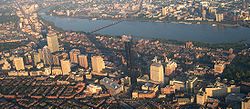
Since the 1755 earthquake, Boston and its surrounding towns have become a major metropolitan area. Much new construction has been built on infill, especially in the Back Bay area, which may be prone to greater shaking and to compaction of the sand and gravel used as fill. Many older buildings in the Boston area are built from stone and brick, and are likely to collapse completely during a major earthquake. Given this, modern observers have expressed concern about the effects of another quake in such a major city. A 1990 study by the Massachusetts Emergency Management Agency
estimated potential financial losses at between $4 billion and $5 billion, and potential loss of life in the hundreds. As a consequence, the state has updated building codes and zoning laws to require that new construction and additions in vulnerable areas be built to resist earthquakes.
Province of Massachusetts Bay
The Province of Massachusetts Bay was a crown colony in North America. It was chartered on October 7, 1691 by William and Mary, the joint monarchs of the kingdoms of England and Scotland...
(the present-day American commonwealth of Massachusetts
Massachusetts
The Commonwealth of Massachusetts is a state in the New England region of the northeastern United States of America. It is bordered by Rhode Island and Connecticut to the south, New York to the west, and Vermont and New Hampshire to the north; at its east lies the Atlantic Ocean. As of the 2010...
) on November 18, 1755. At between 6.0 and 6.3 on the Richter scale, it remains the largest earthquake
Earthquake
An earthquake is the result of a sudden release of energy in the Earth's crust that creates seismic waves. The seismicity, seismism or seismic activity of an area refers to the frequency, type and size of earthquakes experienced over a period of time...
in the history of Massachusetts. It damaged hundreds of buildings in Boston
Boston
Boston is the capital of and largest city in Massachusetts, and is one of the oldest cities in the United States. The largest city in New England, Boston is regarded as the unofficial "Capital of New England" for its economic and cultural impact on the entire New England region. The city proper had...
and was felt as far north as Nova Scotia
Nova Scotia
Nova Scotia is one of Canada's three Maritime provinces and is the most populous province in Atlantic Canada. The name of the province is Latin for "New Scotland," but "Nova Scotia" is the recognized, English-language name of the province. The provincial capital is Halifax. Nova Scotia is the...
and as far south as South Carolina
South Carolina
South Carolina is a state in the Deep South of the United States that borders Georgia to the south, North Carolina to the north, and the Atlantic Ocean to the east. Originally part of the Province of Carolina, the Province of South Carolina was one of the 13 colonies that declared independence...
. Sailors on a ship more than 200 miles (321.9 km) offshore felt the quake, and mistook it at first for their ship running aground. Many residents of Boston and the surrounding areas attributed the quake to God, and it occasioned a brief increase in religious fervor in the city. Modern studies estimate that if a similar quake shook Boston today, it would result in as much as $5 billion in damage and hundreds of deaths.
Epicenter
The earthquake took place on November 18, 1755, at approximately 4:30 AM. Its epicenter is believed to have been offshore, approximately 24 miles (38.6 km) east of Cape AnnCape Ann
Cape Ann is a rocky cape in northeastern Massachusetts on the Atlantic Ocean. The cape is located approximately 30 miles northeast of Boston and forms the northern edge of Massachusetts Bay. Cape Ann includes the city of Gloucester, and the towns of Essex, Manchester-by-the-Sea, and...
. The quake was felt as far north as Halifax
City of Halifax
Halifax is a city in Canada, which was the capital of the province of Nova Scotia and shire town of Halifax County. It was the largest city in Atlantic Canada until it was amalgamated into Halifax Regional Municipality in 1996...
, Nova Scotia
Nova Scotia
Nova Scotia is one of Canada's three Maritime provinces and is the most populous province in Atlantic Canada. The name of the province is Latin for "New Scotland," but "Nova Scotia" is the recognized, English-language name of the province. The provincial capital is Halifax. Nova Scotia is the...
, south to the Chesapeake Bay
Chesapeake Bay
The Chesapeake Bay is the largest estuary in the United States. It lies off the Atlantic Ocean, surrounded by Maryland and Virginia. The Chesapeake Bay's drainage basin covers in the District of Columbia and parts of six states: New York, Pennsylvania, Delaware, Maryland, Virginia, and West...
and South Carolina
South Carolina
South Carolina is a state in the Deep South of the United States that borders Georgia to the south, North Carolina to the north, and the Atlantic Ocean to the east. Originally part of the Province of Carolina, the Province of South Carolina was one of the 13 colonies that declared independence...
, and from Lake George
Lake George (New York)
Lake George, nicknamed the Queen of American Lakes, is a long, narrow oligotrophic lake draining northwards into Lake Champlain and the St. Lawrence River Drainage basin located at the southeast base of the Adirondack Mountains in northern New York, U.S.A.. It lies within the upper region of the...
and Lake Champlain
Lake Champlain
Lake Champlain is a natural, freshwater lake in North America, located mainly within the borders of the United States but partially situated across the Canada—United States border in the Canadian province of Quebec.The New York portion of the Champlain Valley includes the eastern portions of...
in the northwest to a ship 200 miles (321.9 km) off the east coast. Sailors on the ship reported that the quake was so strong, they had feared that they had run aground. The region experienced a number of aftershock
Aftershock
An aftershock is a smaller earthquake that occurs after a previous large earthquake, in the same area of the main shock. If an aftershock is larger than the main shock, the aftershock is redesignated as the main shock and the original main shock is redesignated as a foreshock...
s, the first of which was a little more than an hour after the quake. Most of these aftershocks could not be felt in Boston, affecting only the northeastern coast of the colony.
Modern research has estimated that the quake was between 6.0 and 6.3 on the Richter scale, and the United States Geological Survey
United States Geological Survey
The United States Geological Survey is a scientific agency of the United States government. The scientists of the USGS study the landscape of the United States, its natural resources, and the natural hazards that threaten it. The organization has four major science disciplines, concerning biology,...
calls it the largest earthquake in the history of Massachusetts. Scientists are unclear on the causes of this and other quakes in the northeastern United States
United States
The United States of America is a federal constitutional republic comprising fifty states and a federal district...
. There are a number of old faults in the region, but none of them are known to still be active. It is possible that the Cape Ann earthquake may have been remotely triggered by a larger earthquake in Lisbon, Portugal
1755 Lisbon earthquake
The 1755 Lisbon earthquake, also known as the Great Lisbon Earthquake, was a megathrust earthquake that took place on Saturday 1 November 1755, at around 9:40 in the morning. The earthquake was followed by fires and a tsunami, which almost totally destroyed Lisbon in the Kingdom of Portugal, and...
a few weeks prior, although there is not enough evidence to prove that they are linked.
Damage
Boston and Cape Ann were the most heavily damaged. In Boston, damage was concentrated in areas of infillInfill
Infill in its broadest meaning is material that fills in an otherwise unoccupied space. The term is commonly used in association with construction techniques such as wattle and daub, and civil engineering activities such as land reclamation.-Construction:...
near the harbor; infill is less sturdy in earthquakes than solid land. From 1,300 to 1,600 chimneys in the city were damaged in some way, the gable ends of some houses collapsed, and a number of roofs were damaged by falling chimneys. Stone chimneys and buildings were damaged in Falmouth (present-day Portland, Maine
Portland, Maine
Portland is the largest city in Maine and is the county seat of Cumberland County. The 2010 city population was 66,194, growing 3 percent since the census of 2000...
), Springfield, Massachusetts
Springfield, Massachusetts
Springfield is the most populous city in Western New England, and the seat of Hampden County, Massachusetts, United States. Springfield sits on the eastern bank of the Connecticut River near its confluence with three rivers; the western Westfield River, the eastern Chicopee River, and the eastern...
, and New Haven, Connecticut
New Haven, Connecticut
New Haven is the second-largest city in Connecticut and the sixth-largest in New England. According to the 2010 Census, New Haven's population increased by 5.0% between 2000 and 2010, a rate higher than that of the State of Connecticut, and higher than that of the state's five largest cities, and...
as well. Some church steeples in Boston were damaged, ending up tilted from vertical. Wooden buildings received very little damage because they were more flexible. Stone fencing in rural areas was damaged. Observers also reported that several springs dried up, new ones were created, and cracks appeared in the ground near Scituate
Scituate, Massachusetts
Scituate is a seacoast town in Plymouth County, Massachusetts, United States, on the South Shore, midway between Boston and Plymouth. The population was 18,133 at the 2010 census....
, Lancaster
Lancaster, Massachusetts
Lancaster is a town in Worcester County, Massachusetts, in the United States. Incorporated in 1653, Lancaster is the oldest town in Worcester County...
, and Pembroke
Pembroke, Massachusetts
Pembroke is a town in Plymouth County, Massachusetts, United States. The population was 16,927 at the 2000 census.The southwestern section of Pembroke is also known as Bryantville...
. In this last town, observers noted water and fine sand coming from the crack. Non-structural damage was minor; residents reported damage to china and glassware, and a distiller lost some of his product after a cistern was damaged. The Cape Ann earthquake may also have created the first recorded tsunami
Tsunami
A tsunami is a series of water waves caused by the displacement of a large volume of a body of water, typically an ocean or a large lake...
in U.S. history. Observers in the Leeward Islands
Leeward Islands
The Leeward Islands are a group of islands in the West Indies. They are the northern islands of the Lesser Antilles chain. As a group they start east of Puerto Rico and reach southward to Dominica. They are situated where the northeastern Caribbean Sea meets the western Atlantic Ocean...
nearly 1000 miles (1,609.3 km) south of Cape Ann, reported a receding of water followed by a large wave that lifted several boats ashore and left fish floundering on the beach.
Legacy
Thomas Prince
Thomas Prince was an American clergyman, scholar and historian noted for his historical text A Chronological History of New England, in the Form of Annals...
's Earthquakes the Works of God and Tokens of his Just Displeasure. Not all explanations of the event were theological; John Winthrop, a Harvard professor, proposed an alternate explanation having to do with heat and chemical vapors inside the surface of the earth.
Since the 1755 earthquake, Boston and its surrounding towns have become a major metropolitan area. Much new construction has been built on infill, especially in the Back Bay area, which may be prone to greater shaking and to compaction of the sand and gravel used as fill. Many older buildings in the Boston area are built from stone and brick, and are likely to collapse completely during a major earthquake. Given this, modern observers have expressed concern about the effects of another quake in such a major city. A 1990 study by the Massachusetts Emergency Management Agency
Massachusetts Emergency Management Agency
The Massachusetts Emergency Management Agency is a Commonwealth of Massachusetts agency. The Massachusetts Emergency Management Agency is the Agency that coordinates Federal, State, local and private resources throughout the Commonwealth during times of disasters and emergencies.It is...
estimated potential financial losses at between $4 billion and $5 billion, and potential loss of life in the hundreds. As a consequence, the state has updated building codes and zoning laws to require that new construction and additions in vulnerable areas be built to resist earthquakes.