
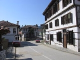
Zlatograd
Encyclopedia
Zlatograd is a town in Smolyan Province
, Southern-central Bulgaria
. It is the administrative centre of the homonymous Zlatograd Municipality. As of December 2009, the town has a population of 7,110 inhabitants.
Zlatograd is located in a valley between the eastern and central massif of the Rhodope mountains
, 60 km
away from the province centre - Smolyan
. The Greek
border lies just 5 km away from the town and on 15 January 2010 the cross-border Zlatograd - Thermes (Greece) road was inaugurated.
During the rule of the Ottoman Empire, the area was a township of the Ottoman Gümülcine
sanjak
in Edirne
vilayet between 1867 and 1912 as "Darıdere".
Mineral resources: lead
-zinc
ore;
Water resources:: The territory of the municipality is crossed by Varbitza river which is 98.1 km long and its catchment basin is 1202.8 km. Nedelinska and Kushlenska rivers are tributaries of Varbitza. There is a dam lake called "Zlatograd" with water capacity of 4,4.106 m . and a micro dam lake called "Hasidere" (0,4.106 m).
Soils: maroon forest leached (97.59 km²); brown forest-dark (12 km²); brown forest-transient (83.37 km²); brown forest light (117.59 km²); alluvial-delluvial (0.59 km²); humus-carbonate (11.07 km²);
Forest Fund: It covers an area of 144.60 km². The following species like beech, hornbeam, oak, birch and cornel-tree are mostly spread among the broad-leaved forests. Prevailing coniferous trees are spruce, fir-tree, white and black pine.
Environment: There is a tailings pond called "Erma Reka" which is 8 km away from the town of Zlatograd and 5 km away from the village of Erma Reka. The municipality is rich in underground resources. In the surroundings of Erma Reka there is a geothermal deposit of hot mineral water.
Labour force and unemployment: The rate of unemployment is 32.64 %, which is the highest since 1990. The active population is 8,063 citizens of whom 50,97 % are employed in the public sector and 49.03 % in the private sector.
Agricultural Fund: It covers 25 km² and the arable land is 12 km². The cultures grown in the municipality are tobacco, potatoes, vegetables and strawberries (representatives of perennial plants).
on Livingston Island in the South Shetland Islands
, Antarctica is named after Zlatograd.
Smolyan Province
-Religion:The Smolyan province along with the Kardzhali Province is a province where the predominant religion is not Orthodox Christianity but Islam. However, unlike Kardzhali where the majority of the population is Turkish, the Muslim population of the Smolyan province is made up almost entirely...
, Southern-central Bulgaria
Bulgaria
Bulgaria , officially the Republic of Bulgaria , is a parliamentary democracy within a unitary constitutional republic in Southeast Europe. The country borders Romania to the north, Serbia and Macedonia to the west, Greece and Turkey to the south, as well as the Black Sea to the east...
. It is the administrative centre of the homonymous Zlatograd Municipality. As of December 2009, the town has a population of 7,110 inhabitants.
Zlatograd is located in a valley between the eastern and central massif of the Rhodope mountains
Rhodope Mountains
The Rhodopes are a mountain range in Southeastern Europe, with over 83% of its area in southern Bulgaria and the remainder in Greece. Its highest peak, Golyam Perelik , is the seventh highest Bulgarian mountain...
, 60 km
Kilometre
The kilometre is a unit of length in the metric system, equal to one thousand metres and is therefore exactly equal to the distance travelled by light in free space in of a second...
away from the province centre - Smolyan
Smolyan
Smolyan is a town and ski resort in the very south of Bulgaria not far from the border with Greece. It is the administrative and industrial centre of the homonymous Smolyan Province...
. The Greek
Greece
Greece , officially the Hellenic Republic , and historically Hellas or the Republic of Greece in English, is a country in southeastern Europe....
border lies just 5 km away from the town and on 15 January 2010 the cross-border Zlatograd - Thermes (Greece) road was inaugurated.
During the rule of the Ottoman Empire, the area was a township of the Ottoman Gümülcine
Komotini
Komotini is a city in Thrace, northeastern Greece. It is the capital of the region of East Macedonia and Thrace and of the Rhodope regional unit. It is also the administrative center of the Rhodope-Evros super-prefecture. The city is home to the Democritus University of Thrace, founded in 1973...
sanjak
Sanjak
Sanjaks were administrative divisions of the Ottoman Empire. Sanjak, and the variant spellings sandjak, sanjaq, and sinjaq, are English transliterations of the Turkish word sancak, meaning district, banner, or flag...
in Edirne
Edirne
Edirne is a city in Eastern Thrace, the northwestern part of Turkey, close to the borders with Greece and Bulgaria. Edirne served as the capital city of the Ottoman Empire from 1365 to 1453, before Constantinople became the empire's new capital. At present, Edirne is the capital of the Edirne...
vilayet between 1867 and 1912 as "Darıdere".
Description
Climate: The municipality is included in the transient-Mediterranean climate region.Mineral resources: lead
Lead
Lead is a main-group element in the carbon group with the symbol Pb and atomic number 82. Lead is a soft, malleable poor metal. It is also counted as one of the heavy metals. Metallic lead has a bluish-white color after being freshly cut, but it soon tarnishes to a dull grayish color when exposed...
-zinc
Zinc
Zinc , or spelter , is a metallic chemical element; it has the symbol Zn and atomic number 30. It is the first element in group 12 of the periodic table. Zinc is, in some respects, chemically similar to magnesium, because its ion is of similar size and its only common oxidation state is +2...
ore;
Water resources:: The territory of the municipality is crossed by Varbitza river which is 98.1 km long and its catchment basin is 1202.8 km. Nedelinska and Kushlenska rivers are tributaries of Varbitza. There is a dam lake called "Zlatograd" with water capacity of 4,4.106 m . and a micro dam lake called "Hasidere" (0,4.106 m).
Soils: maroon forest leached (97.59 km²); brown forest-dark (12 km²); brown forest-transient (83.37 km²); brown forest light (117.59 km²); alluvial-delluvial (0.59 km²); humus-carbonate (11.07 km²);
Forest Fund: It covers an area of 144.60 km². The following species like beech, hornbeam, oak, birch and cornel-tree are mostly spread among the broad-leaved forests. Prevailing coniferous trees are spruce, fir-tree, white and black pine.
Environment: There is a tailings pond called "Erma Reka" which is 8 km away from the town of Zlatograd and 5 km away from the village of Erma Reka. The municipality is rich in underground resources. In the surroundings of Erma Reka there is a geothermal deposit of hot mineral water.
Labour force and unemployment: The rate of unemployment is 32.64 %, which is the highest since 1990. The active population is 8,063 citizens of whom 50,97 % are employed in the public sector and 49.03 % in the private sector.
Agricultural Fund: It covers 25 km² and the arable land is 12 km². The cultures grown in the municipality are tobacco, potatoes, vegetables and strawberries (representatives of perennial plants).
Honour
Zlatograd RockZlatograd Rock
Zlatograd Rock is a rocky 240 m peak forming the eastern extremity of Bowles Ridge, Livingston Island in the South Shetland Islands, Antarctica. The peak overlooks Struma Glacier to the northwest and Huron Glacier to the southeast...
on Livingston Island in the South Shetland Islands
South Shetland Islands
The South Shetland Islands are a group of Antarctic islands, lying about north of the Antarctic Peninsula, with a total area of . By the Antarctic Treaty of 1959, the Islands' sovereignty is neither recognized nor disputed by the signatories and they are free for use by any signatory for...
, Antarctica is named after Zlatograd.