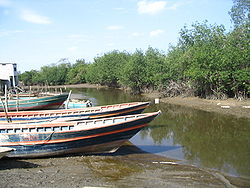
Zarumilla River
Encyclopedia
The Zarumilla River is a river
in South America
that marks the border between Peru
and Ecuador
. It is named after the Peruvian town of Zarumilla
.
 It is part of the Gulf of Guayaquil-Tumbes mangroves
Sanctuary and its currents, sediments, and tides strongly influence the geomorphology of the area. It empties into the Gulf of Guayaquil
.
The largest towns on its banks are Huaquillas
, in the Ecuadorian province of El Oro
, and Aguas Verdes
in the Tumbes Region
of Peru; both towns are connected by an international bridge. The water flows through a canal
as the river passes these populated areas. Pollution is a problem in this part of the river, as people from both countries discharge their waste into the canal.
marker and therefore gives them rights in the affected area. The Peruvians argued that the area is sovereign Peruvian soil.

River
A river is a natural watercourse, usually freshwater, flowing towards an ocean, a lake, a sea, or another river. In a few cases, a river simply flows into the ground or dries up completely before reaching another body of water. Small rivers may also be called by several other names, including...
in South America
South America
South America is a continent situated in the Western Hemisphere, mostly in the Southern Hemisphere, with a relatively small portion in the Northern Hemisphere. The continent is also considered a subcontinent of the Americas. It is bordered on the west by the Pacific Ocean and on the north and east...
that marks the border between Peru
Peru
Peru , officially the Republic of Peru , is a country in western South America. It is bordered on the north by Ecuador and Colombia, on the east by Brazil, on the southeast by Bolivia, on the south by Chile, and on the west by the Pacific Ocean....
and Ecuador
Ecuador
Ecuador , officially the Republic of Ecuador is a representative democratic republic in South America, bordered by Colombia on the north, Peru on the east and south, and by the Pacific Ocean to the west. It is one of only two countries in South America, along with Chile, that do not have a border...
. It is named after the Peruvian town of Zarumilla
Zarumilla
Zarumilla is a town in the Tumbes Region, in northwestern Peru. It has a population of 17,587 and is the capital of the Zarumilla Province...
.

Gulf of Guayaquil-Tumbes mangroves
The Gulf of Guayaquil-Tumbes mangroves are an ecoregion located in the Gulf of Guayaquil in South America, in northern Peru and southern Ecuador. It has an area of 3,300 km² ....
Sanctuary and its currents, sediments, and tides strongly influence the geomorphology of the area. It empties into the Gulf of Guayaquil
Gulf of Guayaquil
The Gulf of Guayaquil is a large body of water of the Pacific Ocean in western South America. Its northern limit is the city of Salinas, in Ecuador, and its southern limit is Punta Pariñas, in Peru.The gulf takes its name from the city of Guayaquil...
.
The largest towns on its banks are Huaquillas
Huaquillas
Huaquillas is a town in western El Oro, a province of SW Ecuador. It is the canton seat of the Huaquillas Canton.Huaquillas is located on the border with Peru. An international bridge that goes over the Zarumilla River connects it with the Peruvian town of Aguas Verdes...
, in the Ecuadorian province of El Oro
El Oro Province
El Oro province is the southernmost of Ecuador's coastal provinces. It was named for its historically important gold production. Today it is one of the world's major exporters of bananas. The capital is Machala.-Geography:To the north and east the province has borders with the provinces Guayas,...
, and Aguas Verdes
Aguas Verdes
Aguas Verdes , is a town in the Zarumilla Province of the Tumbes Region in northwestern Peru. It has a population of 2,390 and is capital of the Aguas Verdes District....
in the Tumbes Region
Tumbes Region
Tumbes is a coastal region in northwestern Peru and southwestern Ecuador. Due to the region's location near the Equator it has a warm climate, with beaches that are considered among the finest in Peru...
of Peru; both towns are connected by an international bridge. The water flows through a canal
Canal
Canals are man-made channels for water. There are two types of canal:#Waterways: navigable transportation canals used for carrying ships and boats shipping goods and conveying people, further subdivided into two kinds:...
as the river passes these populated areas. Pollution is a problem in this part of the river, as people from both countries discharge their waste into the canal.
Border issues
In 1998, during El Niño, the river changed its course, moving 1 square kilometre of land into its eastern margin. Ecuadorians took advantage of this situation, saying that the river is the natural borderBorder
Borders define geographic boundaries of political entities or legal jurisdictions, such as governments, sovereign states, federated states and other subnational entities. Some borders—such as a state's internal administrative borders, or inter-state borders within the Schengen Area—are open and...
marker and therefore gives them rights in the affected area. The Peruvians argued that the area is sovereign Peruvian soil.


