

ZOOMQ3D
Encyclopedia
Finite difference
A finite difference is a mathematical expression of the form f − f. If a finite difference is divided by b − a, one gets a difference quotient...
model, which simulates groundwater
Groundwater
Groundwater is water located beneath the ground surface in soil pore spaces and in the fractures of rock formations. A unit of rock or an unconsolidated deposit is called an aquifer when it can yield a usable quantity of water. The depth at which soil pore spaces or fractures and voids in rock...
flow in aquifer
Aquifer
An aquifer is a wet underground layer of water-bearing permeable rock or unconsolidated materials from which groundwater can be usefully extracted using a water well. The study of water flow in aquifers and the characterization of aquifers is called hydrogeology...
s. The program is used by hydrogeologists
Hydrogeology
Hydrogeology is the area of geology that deals with the distribution and movement of groundwater in the soil and rocks of the Earth's crust, . The term geohydrology is often used interchangeably...
to investigate groundwater
Groundwater
Groundwater is water located beneath the ground surface in soil pore spaces and in the fractures of rock formations. A unit of rock or an unconsolidated deposit is called an aquifer when it can yield a usable quantity of water. The depth at which soil pore spaces or fractures and voids in rock...
resources and to make predictions about possible future changes in their quantity and quality. The code is written in C++
C++
C++ is a statically typed, free-form, multi-paradigm, compiled, general-purpose programming language. It is regarded as an intermediate-level language, as it comprises a combination of both high-level and low-level language features. It was developed by Bjarne Stroustrup starting in 1979 at Bell...
, an object-oriented programming
Object-oriented programming
Object-oriented programming is a programming paradigm using "objects" – data structures consisting of data fields and methods together with their interactions – to design applications and computer programs. Programming techniques may include features such as data abstraction,...
language and can compile and run on Windows
Microsoft Windows
Microsoft Windows is a series of operating systems produced by Microsoft.Microsoft introduced an operating environment named Windows on November 20, 1985 as an add-on to MS-DOS in response to the growing interest in graphical user interfaces . Microsoft Windows came to dominate the world's personal...
and Unix
Unix
Unix is a multitasking, multi-user computer operating system originally developed in 1969 by a group of AT&T employees at Bell Labs, including Ken Thompson, Dennis Ritchie, Brian Kernighan, Douglas McIlroy, and Joe Ossanna...
operating systems.
Groundwater flow equation
ZOOMQ3D applies a quasi-three dimensional finite-differenceFinite difference
A finite difference is a mathematical expression of the form f − f. If a finite difference is divided by b − a, one gets a difference quotient...
approximation to the general three-dimensional governing partial differential
Partial differential equation
In mathematics, partial differential equations are a type of differential equation, i.e., a relation involving an unknown function of several independent variables and their partial derivatives with respect to those variables...
groundwater flow equation
Groundwater flow equation
Used in hydrogeology, the groundwater flow equation is the mathematical relationship which is used to describe the flow of groundwater through an aquifer. The transient flow of groundwater is described by a form of the diffusion equation, similar to that used in heat transfer to describe the flow...
:
where:
 is the potentiometric head at a point
  and time
  (L)
(L) ,
,  and
and  are the values of hydraulic conductivityHydraulic conductivityHydraulic conductivity, symbolically represented as K, is a property of vascular plants, soil or rock, that describes the ease with which water can move through pore spaces or fractures. It depends on the intrinsic permeability of the material and on the degree of saturation...
along the x, y, and z coordinate axes (LT−1) is a volumetric fluxVolumetric fluxIn fluid dynamics, the volumetric flux is the rate of volume flow across a unit area . The density of a particular property in a fluid's volume, multiplied with the volumetric flux of the fluid, thus defines the advective flux of that property...
per unit volume representing sources and/or sinks of water, where negative values are abstractions, and positive values are injections (T−1) and, is the specific storageSpecific storageSpecific storage , storativity , specific yield and specific capacity are material physical properties that characterize the capacity of an aquifer to release groundwater from storage in response to a decline in hydraulic head. For that reason they are sometimes referred to as "storage properties"...
of the porous material (L−1)
This equation is derived by considering a flow balance for an infinitesimally small volume element located anywhere within a body of saturated aquifer. A number of assumptions underlie this equation. First, the fluid is assumed to be of constant density; this allows the flow balance to be a consequence of mass conservation within the element. Next, the Cartesian coordinate system is aligned with the principal axes of the hydraulic conductivity tensor; this avoids the need for cross derivatives.
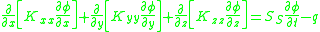
A model, based on the above equation, incorporating appropriate boundary and initial conditions, would be truly three-dimensional. ZOOMQ3D takes a simplifying approach to the solution of the three-dimensional equation by recognising that in many aquifers it is possible to identify a layered structure. If the layers are aligned parallel to the horizontal coordinate axes, then the three-dimensional equation can be integrated vertically across the layer to produce an equation which describes the flow within a layer and its interactions with adjacent layers. Such an equation is:

where:
 is the potentiometric head within a layer (L)
 is time (T)
 and
and  are the values of transmissivity along the x and y coordinate axes (L2T−1)
 is a volumetric fluxFluxIn the various subfields of physics, there exist two common usages of the term flux, both with rigorous mathematical frameworks.* In the study of transport phenomena , flux is defined as flow per unit area, where flow is the movement of some quantity per time...
per unit plan area representing sources and/or sinks of water, where negative values are abstractions, and positive values are injections (LT−1) is the storage coefficient of the porous material (L0) and,
 above and
  below are leakage rates from layers above and below (LT−1)
Model features
| Feature | Description |
|---|---|
| Multiple layers | ZOOMQ3D can incorporate multiple layers of finite difference nodes. The elevation of these layers can vary across the model and the base elevation of one layer can be higher than the top of the layer below it. The separation of model layers simplifies the representation of groundwater systems that contain aquifers separated aquitards. This because the flow through low permeability layers, which is assumed to be vertical, is represented by the vertical leakage term connecting two finite difference nodes within the upper and lower aquifer. |
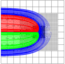
| Local grid refinement | ZOOMQ3D incorporates a mesh refinement procedure which aids the solution of problems related to scale. The density of finite difference nodes can be increased by adding successively finer rectangular grids in discrete areas of the model domain. The mesh can be refined in separate areas and grids can be refined multiple times in the same location in order to zoom into a specific model feature, for example an abstraction borehole or a river reach. |
| Confined - unconfined conditions | Both confined and unconfined aquifers can be modelled. At confined finite difference nodes transmissivity and storage are independent of groundwater head. At unconfined nodes transmissivity is a function of saturated thickness and the storage term incorporates specific yield. In the top model layer finite different nodes can be defined as being confined, unconfined or convertible. Convertible nodes switch between unconfined and confined behaviour when the groundwater head rises above its top elevation. In each of the lower model layers, all the nodes must be specified as being either confined or convertible. Finite difference nodes dewater as the groundwater head drops below their base. In this case the node is removed from the matrix of finite difference equations. |
| Heterogeneity and anisotropy | Models can be heterogeneous and anisotropic. Different hydraulic parameter values can be specified at each finite difference node and hydraulic conductivity may be different in the x and y-directions. It is assumed that the Cartesian co-ordinate system is aligned with the principal axes of the hydraulic conductivity tensor. |
| Moving boundaries | Model nodes can de-water and re-wet. Nodes are made inactive when the groundwater level falls below their base and vice versa. The re-wetting of model nodes depends on the groundwater head in adjacent finite difference nodes. |
| Variable hydraulic conductivity with depth (VKD) | Vertical variations in hydraulic conductivity with depth can be specified within model layers or across model layers by defining VKD profiles. The transmissivity at a node is calculated by integrating the hydraulic conductivity over the vertical saturated thickness of the node. |
| Recharge | Recharge can vary spatially and temporally. Recharge is always applied to the upper-most active node. |
| Abstraction wells | Pumped boreholes can be placed at any node within the model domain. Abstraction rates can vary temporally and wells can both abstract water from the aquifer and inject water into it. |
| Rivers | Dendritic rivers basins are simulated using a series of interconnected river reaches. The hydraulic parameters characterising a reach can vary along the river as can the degree of connection with the aquifer. The transfer of water between the aquifer and rivers is simulated as is the accretion of baseflow along each river branch. Discharges to the river can be specified in any reach, for example to represent a sewage treatment works, and the discharge rate can vary over time. Both fully penterating and perched rivers can be simulated. |
| Head-dependent leakage nodes | In addition to rivers, a second head-dependent leakage mechanism is included in ZOOMQ3D. The flow through leakage nodes is proportional to the difference between its elevation and the groundwater head at the finite difference node to which it is connected. Flow can occur in either direction i.e. into or out of the aquifer. Leakage nodes can be used to model spring flows, lakes or estuaries, for example. |
| Springs | This model feature has been developed to simulated spring flows specifically. The flow out of a spring depends on the transmissivity of the surrounding finite difference nodes. Spring flows are represented by an ‘abstraction’ which removes water from the aquifer at the location of the spring until the water table falls below the level of the ground surface. |
| Time discretisation | Simulation time is divided into time-steps, stress periods and blocks. The length of a time-step is equivalent to the length of time between which successive solutions are calculated for the model’s state variables. A stress period represents a period of time during which all model stresses remain constant e.g. recharge, groundwater abstraction or discharge to rivers. Stress periods are divided into one or more time-steps. A block is composed of one or more stress periods. The rationale for the use of blocks is predominantly related to the simplification of the organisation of time-variant data, for example, groundwater abstraction or recharge rates, within input files. The number of stress periods in each block is the same for all blocks within a simulation. |
History of development
The groundwaterGroundwater
Groundwater is water located beneath the ground surface in soil pore spaces and in the fractures of rock formations. A unit of rock or an unconsolidated deposit is called an aquifer when it can yield a usable quantity of water. The depth at which soil pore spaces or fractures and voids in rock...
flow model ZOOMQ3D is one of the codes in the ZOOM family of numerical groundwater model
Groundwater model
Groundwater models are computer models of groundwater flow systems, and are used by hydrogeologists. Groundwater models are used to simulate and predict aquifer conditions.-Characteristics:...
s which also consists of the advective transport particle tracking code ZOOPT and the distributed recharge model ZOODRM. Each of these models has been developed using object-oriented
Object-oriented programming
Object-oriented programming is a programming paradigm using "objects" – data structures consisting of data fields and methods together with their interactions – to design applications and computer programs. Programming techniques may include features such as data abstraction,...
techniques, a programming
Computer programming
Computer programming is the process of designing, writing, testing, debugging, and maintaining the source code of computer programs. This source code is written in one or more programming languages. The purpose of programming is to create a program that performs specific operations or exhibits a...
approach commonly applied in commercial software development but only relatively recently adopted in numerical modelling for scientific analysis.
ZOOMQ3D and ZOOPT have been developed through a tri-partite collaboration between the School of Civil Engineering of the University of Birmingham
University of Birmingham
The University of Birmingham is a British Redbrick university located in the city of Birmingham, England. It received its royal charter in 1900 as a successor to Birmingham Medical School and Mason Science College . Birmingham was the first Redbrick university to gain a charter and thus...
, UK, the British Geological Survey
British Geological Survey
The British Geological Survey is a partly publicly funded body which aims to advance geoscientific knowledge of the United Kingdom landmass and its continental shelf by means of systematic surveying, monitoring and research. The BGS headquarters are in Keyworth, Nottinghamshire, but other centres...
and the Environment Agency
Environment Agency
The Environment Agency is a British non-departmental public body of the Department for Environment, Food and Rural Affairs and an Assembly Government Sponsored Body of the Welsh Assembly Government that serves England and Wales.-Purpose:...
of England and Wales. The distributed recharge model ZOODRM has been developed by the British Geological Survey
British Geological Survey
The British Geological Survey is a partly publicly funded body which aims to advance geoscientific knowledge of the United Kingdom landmass and its continental shelf by means of systematic surveying, monitoring and research. The BGS headquarters are in Keyworth, Nottinghamshire, but other centres...
. All models are maintained by the British Geological Survey
British Geological Survey
The British Geological Survey is a partly publicly funded body which aims to advance geoscientific knowledge of the United Kingdom landmass and its continental shelf by means of systematic surveying, monitoring and research. The BGS headquarters are in Keyworth, Nottinghamshire, but other centres...
.
Link to the geological modelling package GSI3D
A link exists between ZOOMQ3D and the geogical modelling software GSI3DGSI3D
GSI3D is a methodology and associated software tool for 3D geologic modeling developed by Hans-Georg Sobisch over the last 17 years initially in collaboration with the Geological Survey of Lower Saxony...
. The link facilitates the transfer of the structure of a geological model into a ZOOMQ3D groundwater model. After a GSI3D
GSI3D
GSI3D is a methodology and associated software tool for 3D geologic modeling developed by Hans-Georg Sobisch over the last 17 years initially in collaboration with the Geological Survey of Lower Saxony...
geological model is constructed it can be used to create a hydrogeological
Hydrogeology
Hydrogeology is the area of geology that deals with the distribution and movement of groundwater in the soil and rocks of the Earth's crust, . The term geohydrology is often used interchangeably...
model of an aquifer
Aquifer
An aquifer is a wet underground layer of water-bearing permeable rock or unconsolidated materials from which groundwater can be usefully extracted using a water well. The study of water flow in aquifers and the characterization of aquifers is called hydrogeology...
. This is achieved by assigning hydrogeological parameters, such as hydraulic conductivity
Hydraulic conductivity
Hydraulic conductivity, symbolically represented as K, is a property of vascular plants, soil or rock, that describes the ease with which water can move through pore spaces or fractures. It depends on the intrinsic permeability of the material and on the degree of saturation...
, to the geological units. Once this has been completed the resulting hydrogeological model can then be converted to a layered ZOOMQ3D groundwater model.
External links
- ZOOM website www.oomodels.info
- ZOOM documentation
- British Geological Survey ZOOM web page