

Yellow Medicine River
Encyclopedia
Minnesota River
The Minnesota River is a tributary of the Mississippi River, approximately 332 miles long, in the U.S. state of Minnesota. It drains a watershed of nearly , in Minnesota and about in South Dakota and Iowa....
, 107 miles (173 km) long, in southwestern Minnesota
Minnesota
Minnesota is a U.S. state located in the Midwestern United States. The twelfth largest state of the U.S., it is the twenty-first most populous, with 5.3 million residents. Minnesota was carved out of the eastern half of the Minnesota Territory and admitted to the Union as the thirty-second state...
in the United States
United States
The United States of America is a federal constitutional republic comprising fifty states and a federal district...
. Via the Minnesota River, it is part of the watershed
Drainage basin
A drainage basin is an extent or an area of land where surface water from rain and melting snow or ice converges to a single point, usually the exit of the basin, where the waters join another waterbody, such as a river, lake, reservoir, estuary, wetland, sea, or ocean...
of the Mississippi River
Mississippi River
The Mississippi River is the largest river system in North America. Flowing entirely in the United States, this river rises in western Minnesota and meanders slowly southwards for to the Mississippi River Delta at the Gulf of Mexico. With its many tributaries, the Mississippi's watershed drains...
, draining an area of 665 square miles (1,722 km²) in an agricultural region. Its name is a translation of the Dakota
Dakota language
Dakota is a Siouan language spoken by the Dakota people of the Sioux tribes. Dakota is closely related to and mutually intelligible with the Lakota language.-Dialects:...
name for the river, pajutazee, ("huta" meaning "root," "zi" meaning "yellow," and "kapi" meaning "they dig"), for the yellow root of the moonseed
Moonseed
Moonseed is a common name of some flowering plants in the family Menispermaceae:*Cocculus*Menispermum*Moonseed is also a 1998 science fiction book by Stephen Baxter....
plant, which grows in vines along the river.
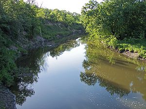
The Yellow Medicine River issues from Lake Shaokatan in Shaokatan Township
Shaokatan Township, Minnesota
Shaokatan Township is a township in Lincoln County, Minnesota, United States. The population was 192 at the 2000 census.-Geography:According to the United States Census Bureau, the township has a total area of 38.3 square miles , of which, 36.7 square miles of it is land and...
in western Lincoln County
Lincoln County, Minnesota
As of the census of 2000, there were 6,429 people, 2,653 households, and 1,785 families residing in the county. The population density was 12 people per square mile . There were 3,043 housing units at an average density of 6 per square mile...
, approximately six miles (10 km) southwest of Ivanhoe
Ivanhoe, Minnesota
As of the census of 2000, there were 679 people, 310 households, and 172 families residing in the city. The population density was 745.2 people per square mile . There were 341 housing units at an average density of 374.3 per square mile . The racial make up of the city was 99.71% White...
, on the Coteau des Prairies
Coteau des Prairies
The Coteau des Prairies is a plateau approximately 200 miles in length and 100 miles in width , rising from the prairie flatlands in eastern South Dakota, southwestern Minnesota, and northwestern Iowa in the United States...
, a morainic
Moraine
A moraine is any glacially formed accumulation of unconsolidated glacial debris which can occur in currently glaciated and formerly glaciated regions, such as those areas acted upon by a past glacial maximum. This debris may have been plucked off a valley floor as a glacier advanced or it may have...
plateau
Plateau
In geology and earth science, a plateau , also called a high plain or tableland, is an area of highland, usually consisting of relatively flat terrain. A highly eroded plateau is called a dissected plateau...
dividing the Mississippi and Missouri River
Missouri River
The Missouri River flows through the central United States, and is a tributary of the Mississippi River. It is the longest river in North America and drains the third largest area, though only the thirteenth largest by discharge. The Missouri's watershed encompasses most of the American Great...
watersheds. It flows initially northeastwardly as an intermittent stream, past Ivanhoe. The stream flows off the Coteau in northeastern Lincoln County, dropping 250 feet (75 m) in five miles (8 km), and turns east-northeastwardly, following a generally treeless course on till plain
Till plain
A till plain is an extensive flat plain of glacial till that forms when a sheet of ice becomes detached from the main body of a glacier and melts in place depositing the sediments it carried. A till plain with irregular topography is referred to as a ground moraine.-See also:*Glacial till plains...
s through northern Lyon County
Lyon County, Minnesota
As of the census of 2000, there were 25,425 people, 9,715 households, and 6,334 families residing in the county. The population density was 36 people per square mile . There were 10,298 housing units at an average density of 14 per square mile...
and eastern Yellow Medicine County
Yellow Medicine County, Minnesota
-External links:***...
, past Hanley Falls
Hanley Falls, Minnesota
Hanley Falls is a city in Yellow Medicine County, Minnesota, United States. The population was 304 at the 2010 census.Hanley Falls has two grain elevators run by the local farmers co-op and is the site of an annual thresher show.-Geography:...
. It flows into the Minnesota River in Upper Sioux Agency State Park
Upper Sioux Agency State Park
Upper Sioux Agency State Park is a Minnesota state park on the Minnesota River, south of Granite Falls. It preserves the site of the historic Yellow Medicine Agency which was destroyed in the Dakota War of 1862.-External links:*...
in Sioux Agency Township
Sioux Agency Township, Minnesota
Sioux Agency Township is a township in Yellow Medicine County, Minnesota, United States. The population was 237 at the 2000 census.-Geography:...
, approximately eight miles (13 km) southeast of Granite Falls
Granite Falls, Minnesota
As of the census of 2000, there were 3,070 people, 1,344 households, and 806 families residing in the city. The population density was 890.5 people per square mile . There were 1,472 housing units at an average density of 427.0 per square mile...
, after dropping 85 feet (30 m) in its final ten miles (15 km) in the Minnesota River valley.
The Yellow Medicine River's largest tributaries are the North Branch Yellow Medicine River and the South Branch Yellow Medicine River, both of which flow for most of their lengths on the Coteau. The North Branch, 41 miles (66 km) long, flows northeastwardly through northern Lincoln County, briefly entering Yellow Medicine County and passing through Porter
Porter, Minnesota
Porter is a city in Yellow Medicine County, Minnesota, United States. The population was 183 at the 2010 census.-Geography:According to the United States Census Bureau, the city has a total area of , of which, of it is land and 0.45% is water...
. The South Branch, 62 miles (99 km) long, flows northeastwardly through Lincoln County into northwestern Lyon County, past Minneota
Minneota, Minnesota
Minneota is a city in Lyon County, Minnesota, United States. The population was 1,392 at the 2010 census.-Geography:According to the United States Census Bureau, the city has a total area of , all of it land...
. Other tributaries of the Yellow Medicine include Spring Creek
Spring Creek (Minnesota)
Spring Creek is a small river in southwestern Minnesota. It is a headwater to the Yellow Medicine River, which is a tributary to the Minnesota River. Springs are the part of the source of the creek's water, hence the name. In the winter, the springs may cause the ice to be thinner and weaker...
, 46 miles (74 km) long, which flows eastwardly through Yellow Medicine County; and Mud Creek, 31 miles (50 km) long, which flows eastwardly through western Yellow Medicine County into northwestern Lyon County.
The Minnesota Pollution Control Agency statistically combines the watershed of the Yellow Medicine River with that of Hawk Creek
Hawk Creek (Minnesota)
-See also:*List of rivers of Minnesota-References:**USGS Hydrologic Unit Map - State of Minnesota...
on the opposite bank of the Minnesota River, as well as small watersheds of nearby Minnesota River tributaries. According to the agency, 81% of the land in the Yellow Medicine-Hawk Creek watersheds is used for agriculture, with corn
Maize
Maize known in many English-speaking countries as corn or mielie/mealie, is a grain domesticated by indigenous peoples in Mesoamerica in prehistoric times. The leafy stalk produces ears which contain seeds called kernels. Though technically a grain, maize kernels are used in cooking as a vegetable...
and soybean
Soybean
The soybean or soya bean is a species of legume native to East Asia, widely grown for its edible bean which has numerous uses...
s being the predominant crops.
Species of fish in the Yellow Medicine River include catfish
Catfish
Catfishes are a diverse group of ray-finned fish. Named for their prominent barbels, which resemble a cat's whiskers, catfish range in size and behavior from the heaviest and longest, the Mekong giant catfish from Southeast Asia and the second longest, the wels catfish of Eurasia, to detritivores...
, carp
Carp
Carp are various species of oily freshwater fish of the family Cyprinidae, a very large group of fish native to Europe and Asia. The cypriniformes are traditionally grouped with the Characiformes, Siluriformes and Gymnotiformes to create the superorder Ostariophysi, since these groups have certain...
, northern pike
Northern Pike
The northern pike , is a species of carnivorous fish of the genus Esox...
, walleye
Walleye
Walleye is a freshwater perciform fish native to most of Canada and to the northern United States. It is a North American close relative of the European pikeperch...
, and bullhead
Bullhead
-Fishes:* Certain sculpins, including:** European bullhead, Cottus gobio** Siberian bullhead, Cottus poecilopus** Norway bullhead, Taurulus Liljeborgi* Catfish of the genus Ameiurus, including:** Black bullhead, Ameiurus melas...
.
Flow rate
At the United States Geological SurveyUnited States Geological Survey
The United States Geological Survey is a scientific agency of the United States government. The scientists of the USGS study the landscape of the United States, its natural resources, and the natural hazards that threaten it. The organization has four major science disciplines, concerning biology,...
's stream gauge
Stream gauge
A stream gauge, stream gage or gauging station is a location used by hydrologists or environmental scientists to monitor and test terrestrial bodies of water. Hydrometric measurements of water surface elevation and/or volumetric discharge are generally taken and observations of biota may also be...
near Granite Falls, 6 miles (10 km) upstream from the river's mouth, the annual mean flow of the river between 1931 and 2005 was 142 cubic feet per second (4 m³/s). The highest recorded flow during the period was 17,200 ft³/s (487 m³/s) on April 10, 1969. Readings of zero were recorded on numerous days during several years.