

Yalobusha County, Mississippi
Encyclopedia
Yalobusha County is a county
located in the U.S. state
of Mississippi
. As of 2010, the population was 12,678. Its county seat
s are Water Valley
and Coffeeville
.
word meaning "tadpole
place," and before the county which bears that name was formed, it was the home of both Choctaw
and Chickasaw
Indian tribes.
In 1816, General Andrew Jackson
ordered the surveying of the Choctaw-Chickasaw Line. The line as surveyed then cut almost a perfect diagonal across the area making up the present day Yalobusha County. The Choctaws ceded their Mississippi
lands to the United States
in 1830 through the Treaty of Dancing Rabbit Creek
. Two years later, the Chickasaw signed the Treaty of Pontotoc, ceding their lands to the United States.
In 1833, the Mississippi Legislature
authorized the formation of 17 counties, including Yalobusha, on what had been Indian
land.
Yalobusha County was officially organized and its first officials elected February 21, 1834. The first Board of Police held its first meeting at Hendersonville, then the largest settlement in the county.
Hendersonville was a settlement established in 1798 by John Henderson, a Presbyterian missionary who was one of the first white men to settle in the county. Other early settlements were Elliot, Chocchuma, Tuscohoma, Pittsburg, Talahoma, Plummerville, Preston, Pharsalia, Sardinia, and Washington.
At its first meeting the Board of Police solicited donations of land for a county seat
, and at its second meeting, the Board selected a site and named it Coffeeville
in honor of General John Coffee
, who had represented the United States in the treaties with both the Choctaws and the Chickasaws. The next Board meeting was held in the new town, and in 1837 the first courthouse
in Coffeeville was built.
Later that same year, one of the early settlers in the northeastern part of the county, G.B. Ragsdale, established a stagecoach
stand near what is now Water Valley
. In 1848 the town of Oakland, Mississippi
was chartered.
Yalobusha County had a population of 12,248 in its first census
, taken in 1840. In 1844, a post office
was opened at Ragsdale's Stand. Three years later, the post office and stagecoach stand were moved to land owned by William Carr, and the name of the post office was changed to Water Valley.
One prominent early Yalobusha County landowner was James K. Polk
, who was later elected President of the United States,. Polk had purchased a plantation
south of Coffeeville in 1835 and after Polk's death, his wife managed the plantation successfully for several years.
In 1850, the county's population was 17,258. In 1852, Calhoun County
was formed, and a tier of townships
on the eastern border of Yalobusha County were taken to form part of the new county.
The Illinois Central Railroad
built a branch line from Jackson, Tennessee
to Grenada
, passing through Water Valley and Coffeeville, in the late 1850s. ICRR officials wanted to set up shops in Coffeeville, but could not obtain the property they wanted. Residents of the fledging town of Water Valley offered to donate the needed land to the railroad; therefore, the shops were located there, and Water Valley quickly became the largest town in the county. It was officially chartered in 1858, and at that time had a population of 300.
In 1860, the county's population was 16,952. Water Valley had become a thriving community with two hotels and several churches. The first church built in Water Valley was the Presbyterian Church built in 1843. Two years later, the First Methodist Church was organized, and in 1860 the First Baptist Church of Water Valley was organized.
With the completion of the railroad from New Orleans
to the Ohio River
, and because the ICRR's shops were located there, Water Valley was an important railroad community on the Mississippi Central railroad at the outset of the Civil War
. In 1862, Union
during General Grant's overland attempt to capture Vicksburg
, Union troops captured Water Valley, but were defeated in battle north of Coffeeville and Grant withdrew, burning most of the town during his retreat.
After the war, the railroad shops were built at Water Valley, bringing a large influx of new residents to the town. In 1867, Yalobusha County's first manufacturing industry, Yacona Mills was the world's largest manufacturer of twine
.
The Reconstruction Legislature in Mississippi
created a number of new counties. Grenada County
was formed in 1870 and included nearly two tiers of townships
which had formerly been the southern part of Yalobusha County.
In March, 1873, Yalobusha County was divided into two judicial districts, and Water Valley was named the county seat of the second judicial district. Because the town overlapped the Yalobusha-Lafayette County line, the legislature gave Yalobusha a two-mile strip of land from the southern portion of Lafayette County
.
The town of Tillatoba
was chartered in 1873. In 1880, Yalobusha County's population was 15,649.
In 1889, Coffeeville's second courthouse, which had been built in 1840 at a cost of $25,000, burned down. A new courthouse, also costing $25,000, was built in 1890. That year, the county population was 16,629.
Famed railroad engineer J. L. "Casey" Jones
moved from Jackson, Tennessee
to Water Valley in 1893. In 1896, four years before his death in a train wreck which brought him fame, Jones moved back to Jackson.
A new courthouse was built in Water Valley in 1896, and 16 years later, it burned down. The second judicial district offices were moved to the Water Valley City Hall, but within a month, it too burned. The courthouse was restored after the fire, and a third floor was added but never completed.
Yalobusha County's population
peaked in 1910, with that year's census
showing a population of 21,519. By 1920, the population had fallen to 18,738, and it continued to decline steadily for the next 50 years.
Between 1926–1928, Yalobusha County suffered two tremendous economic setbacks. In April 1926, Yacona Twine Mill, which had employed approximately 450 people, burned down. The next year, the ICRR began moving its railroad shops from Water Valley to Paducah, Kentucky
. By the end of 1928, these shops, which had at one time employed over 800 people in Water Valley, were gone.
In 1931, the first Watermelon Carnival was held in Water Valley. The carnival was a great success, drawing 20,000 visitors to Water Valley. For the next nine years, the Watermelon Carnival was an annual event bringing national recognition to Water Valley, which was proclaimed the "Watermelon Capital of the World" in 1932. However, the Watermelon Carnival was suspended at the beginning of World War II
, and another one was not held until 1980. Since this time it has been an annual event the first Saturday in August.
There was little industry in Yalobusha County after the war, and in 1950, the county's population was down to 15,191. In the early 1950s the U.S. Army Corps of Engineers began work on two flood control reservoirs
in and around Yalobusha County, much to the distress of county farmers who lost thousands of acres of fertile bottom land. However, Enid Lake
and Grenada Lake
, both completed in 1955, have become popular recreation spots for local people and for visitors from throughout the nation.
Yalobusha County's population was 12,502 in 1960, and in 1970, it bottomed out at 11,915. The 1980 census shows that the county gained over 1,200 new residents since 1970, giving it a population of 13,139.
Since the 1960s, Yalobusha County has been successful in attracting new industries to boost its economic growth. Today, its two largest industrial employers have a combined total of well over 2,000 employees, and several other local industries provide hundreds of additional jobs for county residents.
 As of the census
of 2000, there were 13,051 people, 5,260 households, and 3,597 families residing in the county. The population density
was 28 people per square mile (11/km²). There were 6,224 housing units at an average density of 13 per square mile (5/km²). The racial makeup of the county was 60.46% White
, 38.66% Black
or African American
, 0.21% Native American
, 0.08% Asian
, 0.08% Pacific Islander
, 0.09% from other races
, and 0.41% from two or more races. 0.97% of the population were Hispanic
or Latino
of any race.
There were 5,260 households out of which 29.70% had children under the age of 18 living with them, 46.60% were married couples
living together, 17.60% had a female householder with no husband present, and 31.60% were non-families. 28.70% of all households were made up of individuals and 14.00% had someone living alone who was 65 years of age or older. The average household size was 2.46 and the average family size was 3.02.
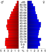
In the county the population was spread out with 25.60% under the age of 18, 8.90% from 18 to 24, 26.10% from 25 to 44, 23.80% from 45 to 64, and 15.70% who were 65 years of age or older. The median age was 38 years. For every 100 females there were 91.30 males. For every 100 females age 18 and over, there were 86.20 males.
The median income for a household in the county was $26,315, and the median income for a family was $31,801. Males had a median income of $27,009 versus $20,236 for females. The per capita income
for the county was $14,953. About 19.50% of families and 21.80% of the population were below the poverty line, including 30.10% of those under age 18 and 21.20% of those age 65 or over.
County (United States)
In the United States, a county is a geographic subdivision of a state , usually assigned some governmental authority. The term "county" is used in 48 of the 50 states; Louisiana is divided into parishes and Alaska into boroughs. Parishes and boroughs are called "county-equivalents" by the U.S...
located in the U.S. state
U.S. state
A U.S. state is any one of the 50 federated states of the United States of America that share sovereignty with the federal government. Because of this shared sovereignty, an American is a citizen both of the federal entity and of his or her state of domicile. Four states use the official title of...
of Mississippi
Mississippi
Mississippi is a U.S. state located in the Southern United States. Jackson is the state capital and largest city. The name of the state derives from the Mississippi River, which flows along its western boundary, whose name comes from the Ojibwe word misi-ziibi...
. As of 2010, the population was 12,678. Its county seat
County seat
A county seat is an administrative center, or seat of government, for a county or civil parish. The term is primarily used in the United States....
s are Water Valley
Water Valley, Mississippi
Water Valley is a city in Yalobusha County, Mississippi, United States. The population was 3,677 at the 2000 census.-Geography:Water Valley is located at ....
and Coffeeville
Coffeeville, Mississippi
Coffeeville is a town in Yalobusha County, Mississippi, United States. The population was 930 at the 2000 census. It is named after John Coffee , a planter and military leader.-Geography:Coffeeville is located at ....
.
History
Yalobusha is a native AmericanNative Americans in the United States
Native Americans in the United States are the indigenous peoples in North America within the boundaries of the present-day continental United States, parts of Alaska, and the island state of Hawaii. They are composed of numerous, distinct tribes, states, and ethnic groups, many of which survive as...
word meaning "tadpole
Tadpole
A tadpole or polliwog is the wholly aquatic larval stage in the life cycle of an amphibian, particularly that of a frog or toad.- Appellation :...
place," and before the county which bears that name was formed, it was the home of both Choctaw
Choctaw
The Choctaw are a Native American people originally from the Southeastern United States...
and Chickasaw
Chickasaw
The Chickasaw are Native American people originally from the region that would become the Southeastern United States...
Indian tribes.
In 1816, General Andrew Jackson
Andrew Jackson
Andrew Jackson was the seventh President of the United States . Based in frontier Tennessee, Jackson was a politician and army general who defeated the Creek Indians at the Battle of Horseshoe Bend , and the British at the Battle of New Orleans...
ordered the surveying of the Choctaw-Chickasaw Line. The line as surveyed then cut almost a perfect diagonal across the area making up the present day Yalobusha County. The Choctaws ceded their Mississippi
Mississippi
Mississippi is a U.S. state located in the Southern United States. Jackson is the state capital and largest city. The name of the state derives from the Mississippi River, which flows along its western boundary, whose name comes from the Ojibwe word misi-ziibi...
lands to the United States
United States
The United States of America is a federal constitutional republic comprising fifty states and a federal district...
in 1830 through the Treaty of Dancing Rabbit Creek
Treaty of Dancing Rabbit Creek
The Treaty of Dancing Rabbit Creek was a treaty signed on September 27, 1830 between the Choctaw and the United States Government. This was the first removal treaty carried into effect under the Indian Removal Act...
. Two years later, the Chickasaw signed the Treaty of Pontotoc, ceding their lands to the United States.
In 1833, the Mississippi Legislature
Mississippi Legislature
The Mississippi Legislature is the state legislature of the U.S. state of Mississippi. The bicameral Legislature is composed of the lower Mississippi House of Representatives, with 122 members, and the upper Mississippi Senate, with 52 members. Both Representatives and Senators serve four-year...
authorized the formation of 17 counties, including Yalobusha, on what had been Indian
Native Americans in the United States
Native Americans in the United States are the indigenous peoples in North America within the boundaries of the present-day continental United States, parts of Alaska, and the island state of Hawaii. They are composed of numerous, distinct tribes, states, and ethnic groups, many of which survive as...
land.
Yalobusha County was officially organized and its first officials elected February 21, 1834. The first Board of Police held its first meeting at Hendersonville, then the largest settlement in the county.
Hendersonville was a settlement established in 1798 by John Henderson, a Presbyterian missionary who was one of the first white men to settle in the county. Other early settlements were Elliot, Chocchuma, Tuscohoma, Pittsburg, Talahoma, Plummerville, Preston, Pharsalia, Sardinia, and Washington.
At its first meeting the Board of Police solicited donations of land for a county seat
County seat
A county seat is an administrative center, or seat of government, for a county or civil parish. The term is primarily used in the United States....
, and at its second meeting, the Board selected a site and named it Coffeeville
Coffeeville, Mississippi
Coffeeville is a town in Yalobusha County, Mississippi, United States. The population was 930 at the 2000 census. It is named after John Coffee , a planter and military leader.-Geography:Coffeeville is located at ....
in honor of General John Coffee
John Coffee
John Coffee was an American planter and military leader. He was considered the most even-tempered and least selfish of Andrew Jackson's lifelong friends...
, who had represented the United States in the treaties with both the Choctaws and the Chickasaws. The next Board meeting was held in the new town, and in 1837 the first courthouse
Courthouse
A courthouse is a building that is home to a local court of law and often the regional county government as well, although this is not the case in some larger cities. The term is common in North America. In most other English speaking countries, buildings which house courts of law are simply...
in Coffeeville was built.
Later that same year, one of the early settlers in the northeastern part of the county, G.B. Ragsdale, established a stagecoach
Stagecoach
A stagecoach is a type of covered wagon for passengers and goods, strongly sprung and drawn by four horses, usually four-in-hand. Widely used before the introduction of railway transport, it made regular trips between stages or stations, which were places of rest provided for stagecoach travelers...
stand near what is now Water Valley
Water Valley, Mississippi
Water Valley is a city in Yalobusha County, Mississippi, United States. The population was 3,677 at the 2000 census.-Geography:Water Valley is located at ....
. In 1848 the town of Oakland, Mississippi
Oakland, Mississippi
Oakland is a town in Yalobusha County, Mississippi, United States. The population was 586 at the time of the 2000 census.-Geography:Oakland is located at ....
was chartered.
Yalobusha County had a population of 12,248 in its first census
Census
A census is the procedure of systematically acquiring and recording information about the members of a given population. It is a regularly occurring and official count of a particular population. The term is used mostly in connection with national population and housing censuses; other common...
, taken in 1840. In 1844, a post office
Post office
A post office is a facility forming part of a postal system for the posting, receipt, sorting, handling, transmission or delivery of mail.Post offices offer mail-related services such as post office boxes, postage and packaging supplies...
was opened at Ragsdale's Stand. Three years later, the post office and stagecoach stand were moved to land owned by William Carr, and the name of the post office was changed to Water Valley.
One prominent early Yalobusha County landowner was James K. Polk
James K. Polk
James Knox Polk was the 11th President of the United States . Polk was born in Mecklenburg County, North Carolina. He later lived in and represented Tennessee. A Democrat, Polk served as the 17th Speaker of the House of Representatives and the 12th Governor of Tennessee...
, who was later elected President of the United States,. Polk had purchased a plantation
Plantation
A plantation is a long artificially established forest, farm or estate, where crops are grown for sale, often in distant markets rather than for local on-site consumption...
south of Coffeeville in 1835 and after Polk's death, his wife managed the plantation successfully for several years.
In 1850, the county's population was 17,258. In 1852, Calhoun County
Calhoun County, Mississippi
Calhoun County is a county located in the U.S. state of Mississippi. As of 2010, the population was 14,962. Its county seat is Pittsboro. Calhoun County is named after John C. Calhoun, the U.S. Vice President and U.S...
was formed, and a tier of townships
Township (United States)
A township in the United States is a small geographic area. Townships range in size from 6 to 54 square miles , with being the norm.The term is used in three ways....
on the eastern border of Yalobusha County were taken to form part of the new county.
The Illinois Central Railroad
Illinois Central Railroad
The Illinois Central Railroad , sometimes called the Main Line of Mid-America, is a railroad in the central United States, with its primary routes connecting Chicago, Illinois with New Orleans, Louisiana and Birmingham, Alabama. A line also connected Chicago with Sioux City, Iowa...
built a branch line from Jackson, Tennessee
Jackson, Tennessee
Jackson is a city in Madison County, Tennessee, United States. The total population was 65,211 at the 2010 census. Jackson is the primary city of the Jackson, Tennessee metropolitan area, which is included in the Jackson-Humboldt, Tennessee Combined Statistical Area...
to Grenada
Grenada, Mississippi
Grenada is a city in Grenada County, Mississippi, United States. The population was 14,879 at the 2000 census. It is the county seat of Grenada County.-History:...
, passing through Water Valley and Coffeeville, in the late 1850s. ICRR officials wanted to set up shops in Coffeeville, but could not obtain the property they wanted. Residents of the fledging town of Water Valley offered to donate the needed land to the railroad; therefore, the shops were located there, and Water Valley quickly became the largest town in the county. It was officially chartered in 1858, and at that time had a population of 300.
In 1860, the county's population was 16,952. Water Valley had become a thriving community with two hotels and several churches. The first church built in Water Valley was the Presbyterian Church built in 1843. Two years later, the First Methodist Church was organized, and in 1860 the First Baptist Church of Water Valley was organized.
With the completion of the railroad from New Orleans
New Orleans, Louisiana
New Orleans is a major United States port and the largest city and metropolitan area in the state of Louisiana. The New Orleans metropolitan area has a population of 1,235,650 as of 2009, the 46th largest in the USA. The New Orleans – Metairie – Bogalusa combined statistical area has a population...
to the Ohio River
Ohio River
The Ohio River is the largest tributary, by volume, of the Mississippi River. At the confluence, the Ohio is even bigger than the Mississippi and, thus, is hydrologically the main stream of the whole river system, including the Allegheny River further upstream...
, and because the ICRR's shops were located there, Water Valley was an important railroad community on the Mississippi Central railroad at the outset of the Civil War
American Civil War
The American Civil War was a civil war fought in the United States of America. In response to the election of Abraham Lincoln as President of the United States, 11 southern slave states declared their secession from the United States and formed the Confederate States of America ; the other 25...
. In 1862, Union
Union (American Civil War)
During the American Civil War, the Union was a name used to refer to the federal government of the United States, which was supported by the twenty free states and five border slave states. It was opposed by 11 southern slave states that had declared a secession to join together to form the...
during General Grant's overland attempt to capture Vicksburg
Vicksburg, Mississippi
Vicksburg is a city in Warren County, Mississippi, United States. It is the only city in Warren County. It is located northwest of New Orleans on the Mississippi and Yazoo rivers, and due west of Jackson, the state capital. In 1900, 14,834 people lived in Vicksburg; in 1910, 20,814; in 1920,...
, Union troops captured Water Valley, but were defeated in battle north of Coffeeville and Grant withdrew, burning most of the town during his retreat.
After the war, the railroad shops were built at Water Valley, bringing a large influx of new residents to the town. In 1867, Yalobusha County's first manufacturing industry, Yacona Mills was the world's largest manufacturer of twine
Twine
Twine is a light string or strong thread composed of two or more smaller strands or yarns twisted together. More generally, the term can be applied to any thin cord....
.
The Reconstruction Legislature in Mississippi
Mississippi
Mississippi is a U.S. state located in the Southern United States. Jackson is the state capital and largest city. The name of the state derives from the Mississippi River, which flows along its western boundary, whose name comes from the Ojibwe word misi-ziibi...
created a number of new counties. Grenada County
Grenada County, Mississippi
-Demographics:As of the census of 2000, there were 23,263 people, 8,820 households, and 6,297 families residing in the county. The population density was 55 people per square mile . There were 9,973 housing units at an average density of 24 per square mile...
was formed in 1870 and included nearly two tiers of townships
Township (United States)
A township in the United States is a small geographic area. Townships range in size from 6 to 54 square miles , with being the norm.The term is used in three ways....
which had formerly been the southern part of Yalobusha County.
In March, 1873, Yalobusha County was divided into two judicial districts, and Water Valley was named the county seat of the second judicial district. Because the town overlapped the Yalobusha-Lafayette County line, the legislature gave Yalobusha a two-mile strip of land from the southern portion of Lafayette County
Lafayette County, Mississippi
-Demographics:As of the census of 2000, there were 38,744 people, 14,373 households, and 8,321 families residing in the county. The population density was 61 people per square mile . There were 16,587 housing units at an average density of 26 per square mile...
.
The town of Tillatoba
Tillatoba, Mississippi
Tillatoba is a town in Yalobusha County, Mississippi, United States. The population was 121 at the 2000 census.Agricultural products produced by the town include cotton, corn, poultry, cattle, and timber...
was chartered in 1873. In 1880, Yalobusha County's population was 15,649.
In 1889, Coffeeville's second courthouse, which had been built in 1840 at a cost of $25,000, burned down. A new courthouse, also costing $25,000, was built in 1890. That year, the county population was 16,629.
Famed railroad engineer J. L. "Casey" Jones
Casey Jones
John Luther Jones was an American railroad engineer from Jackson, Tennessee, who worked for the Illinois Central Railroad...
moved from Jackson, Tennessee
Jackson, Tennessee
Jackson is a city in Madison County, Tennessee, United States. The total population was 65,211 at the 2010 census. Jackson is the primary city of the Jackson, Tennessee metropolitan area, which is included in the Jackson-Humboldt, Tennessee Combined Statistical Area...
to Water Valley in 1893. In 1896, four years before his death in a train wreck which brought him fame, Jones moved back to Jackson.
A new courthouse was built in Water Valley in 1896, and 16 years later, it burned down. The second judicial district offices were moved to the Water Valley City Hall, but within a month, it too burned. The courthouse was restored after the fire, and a third floor was added but never completed.
Yalobusha County's population
Population
A population is all the organisms that both belong to the same group or species and live in the same geographical area. The area that is used to define a sexual population is such that inter-breeding is possible between any pair within the area and more probable than cross-breeding with individuals...
peaked in 1910, with that year's census
Census
A census is the procedure of systematically acquiring and recording information about the members of a given population. It is a regularly occurring and official count of a particular population. The term is used mostly in connection with national population and housing censuses; other common...
showing a population of 21,519. By 1920, the population had fallen to 18,738, and it continued to decline steadily for the next 50 years.
Between 1926–1928, Yalobusha County suffered two tremendous economic setbacks. In April 1926, Yacona Twine Mill, which had employed approximately 450 people, burned down. The next year, the ICRR began moving its railroad shops from Water Valley to Paducah, Kentucky
Paducah, Kentucky
Paducah is the largest city in Kentucky's Jackson Purchase Region and the county seat of McCracken County, Kentucky, United States. It is located at the confluence of the Tennessee River and the Ohio River, halfway between the metropolitan areas of St. Louis, Missouri, to the west and Nashville,...
. By the end of 1928, these shops, which had at one time employed over 800 people in Water Valley, were gone.
In 1931, the first Watermelon Carnival was held in Water Valley. The carnival was a great success, drawing 20,000 visitors to Water Valley. For the next nine years, the Watermelon Carnival was an annual event bringing national recognition to Water Valley, which was proclaimed the "Watermelon Capital of the World" in 1932. However, the Watermelon Carnival was suspended at the beginning of World War II
World War II
World War II, or the Second World War , was a global conflict lasting from 1939 to 1945, involving most of the world's nations—including all of the great powers—eventually forming two opposing military alliances: the Allies and the Axis...
, and another one was not held until 1980. Since this time it has been an annual event the first Saturday in August.
There was little industry in Yalobusha County after the war, and in 1950, the county's population was down to 15,191. In the early 1950s the U.S. Army Corps of Engineers began work on two flood control reservoirs
Water reservoir
A reservoir , artificial lake or dam is used to store water.Reservoirs may be created in river valleys by the construction of a dam or may be built by excavation in the ground or by conventional construction techniques such as brickwork or cast concrete.The term reservoir may also be used to...
in and around Yalobusha County, much to the distress of county farmers who lost thousands of acres of fertile bottom land. However, Enid Lake
Enid Lake
Enid Lake is a lake that is located mostly in Yalobusha County in the U.S. state of Mississippi. Parts of it extend into Panola and Lafayette counties. Common fish species include crappie, largemouth bass, catfish and bream. Enid Lake holds world records for white crappie and shortnose gar...
and Grenada Lake
Grenada Lake
Grenada Lake is a reservoir on the Yalobusha River in the U.S. state of Mississippi. It is one of four flood control lakes in North Mississippi constructed by the U.S. Army Corps of Engineers. Grenada Lake was constructed to help control flooding along the Yazoo River Basin...
, both completed in 1955, have become popular recreation spots for local people and for visitors from throughout the nation.
Yalobusha County's population was 12,502 in 1960, and in 1970, it bottomed out at 11,915. The 1980 census shows that the county gained over 1,200 new residents since 1970, giving it a population of 13,139.
Since the 1960s, Yalobusha County has been successful in attracting new industries to boost its economic growth. Today, its two largest industrial employers have a combined total of well over 2,000 employees, and several other local industries provide hundreds of additional jobs for county residents.
Notable residents
- President James K. PolkJames K. PolkJames Knox Polk was the 11th President of the United States . Polk was born in Mecklenburg County, North Carolina. He later lived in and represented Tennessee. A Democrat, Polk served as the 17th Speaker of the House of Representatives and the 12th Governor of Tennessee...
, who purchased a plantationPlantationA plantation is a long artificially established forest, farm or estate, where crops are grown for sale, often in distant markets rather than for local on-site consumption...
south of Coffeeville in 1835 - Don BriscoeDon BriscoeCecil Donald "Don" Briscoe was an American soap opera actor, most notable for playing Tony Meritt on Days of Our Lives, and, from 1968–1970, for playing Chris Jennings, Tom Jennings, Timothy Shaw, and Chris Collins on Dark Shadows.Briscoe left Dark Shadows abruptly in 1970...
, televisionTelevisionTelevision is a telecommunication medium for transmitting and receiving moving images that can be monochrome or colored, with accompanying sound...
/soap operaSoap operaA soap opera, sometimes called "soap" for short, is an ongoing, episodic work of dramatic fiction presented in serial format on radio or as television programming. The name soap opera stems from the original dramatic serials broadcast on radio that had soap manufacturers, such as Procter & Gamble,...
actor (1940–2004)
Geography
According to the 2000 census, the county has a total area of 495 square miles (1,282 km²), of which 467.12 square miles (1,209.8 km²) (or 94.37%) is land and 27.88 square miles (72.2 km²) (or 5.63%) is water.Major highways
 Interstate 55Interstate 55Interstate 55 is an Interstate Highway in the central United States. Its odd number indicates that it is a north–south Interstate Highway. I-55 goes from LaPlace, Louisiana at Interstate 10 to Chicago at U.S. Route 41 , at McCormick Place. A common nickname for the highway is "double...
 U.S. Highway 51
 Mississippi Highway 7
 Mississippi Highway 32
Adjacent counties
- Lafayette CountyLafayette County, Mississippi-Demographics:As of the census of 2000, there were 38,744 people, 14,373 households, and 8,321 families residing in the county. The population density was 61 people per square mile . There were 16,587 housing units at an average density of 26 per square mile...
(northeast) - Calhoun CountyCalhoun County, MississippiCalhoun County is a county located in the U.S. state of Mississippi. As of 2010, the population was 14,962. Its county seat is Pittsboro. Calhoun County is named after John C. Calhoun, the U.S. Vice President and U.S...
(east) - Grenada CountyGrenada County, Mississippi-Demographics:As of the census of 2000, there were 23,263 people, 8,820 households, and 6,297 families residing in the county. The population density was 55 people per square mile . There were 9,973 housing units at an average density of 24 per square mile...
(south) - Tallahatchie CountyTallahatchie County, Mississippi-National protected areas:*Coldwater River National Wildlife Refuge *Tallahatchie National Wildlife Refuge -Demographics:As of the census of 2000, there were 14,903 people, 5,263 households, and 3,826 families residing in the county. The population density was 23 people per square mile...
(west) - Panola CountyPanola County, Mississippi-Demographics:As of the census of 2000, there were 34,274 people, 12,232 households, and 9,014 families residing in the county. The population density was 50 people per square mile . There were 13,736 housing units at an average density of 20 per square mile...
(northwest)
Demographics
Census
A census is the procedure of systematically acquiring and recording information about the members of a given population. It is a regularly occurring and official count of a particular population. The term is used mostly in connection with national population and housing censuses; other common...
of 2000, there were 13,051 people, 5,260 households, and 3,597 families residing in the county. The population density
Population density
Population density is a measurement of population per unit area or unit volume. It is frequently applied to living organisms, and particularly to humans...
was 28 people per square mile (11/km²). There were 6,224 housing units at an average density of 13 per square mile (5/km²). The racial makeup of the county was 60.46% White
Race (United States Census)
Race and ethnicity in the United States Census, as defined by the Federal Office of Management and Budget and the United States Census Bureau, are self-identification data items in which residents choose the race or races with which they most closely identify, and indicate whether or not they are...
, 38.66% Black
Race (United States Census)
Race and ethnicity in the United States Census, as defined by the Federal Office of Management and Budget and the United States Census Bureau, are self-identification data items in which residents choose the race or races with which they most closely identify, and indicate whether or not they are...
or African American
Race (United States Census)
Race and ethnicity in the United States Census, as defined by the Federal Office of Management and Budget and the United States Census Bureau, are self-identification data items in which residents choose the race or races with which they most closely identify, and indicate whether or not they are...
, 0.21% Native American
Race (United States Census)
Race and ethnicity in the United States Census, as defined by the Federal Office of Management and Budget and the United States Census Bureau, are self-identification data items in which residents choose the race or races with which they most closely identify, and indicate whether or not they are...
, 0.08% Asian
Race (United States Census)
Race and ethnicity in the United States Census, as defined by the Federal Office of Management and Budget and the United States Census Bureau, are self-identification data items in which residents choose the race or races with which they most closely identify, and indicate whether or not they are...
, 0.08% Pacific Islander
Race (United States Census)
Race and ethnicity in the United States Census, as defined by the Federal Office of Management and Budget and the United States Census Bureau, are self-identification data items in which residents choose the race or races with which they most closely identify, and indicate whether or not they are...
, 0.09% from other races
Race (United States Census)
Race and ethnicity in the United States Census, as defined by the Federal Office of Management and Budget and the United States Census Bureau, are self-identification data items in which residents choose the race or races with which they most closely identify, and indicate whether or not they are...
, and 0.41% from two or more races. 0.97% of the population were Hispanic
Race (United States Census)
Race and ethnicity in the United States Census, as defined by the Federal Office of Management and Budget and the United States Census Bureau, are self-identification data items in which residents choose the race or races with which they most closely identify, and indicate whether or not they are...
or Latino
Race (United States Census)
Race and ethnicity in the United States Census, as defined by the Federal Office of Management and Budget and the United States Census Bureau, are self-identification data items in which residents choose the race or races with which they most closely identify, and indicate whether or not they are...
of any race.
There were 5,260 households out of which 29.70% had children under the age of 18 living with them, 46.60% were married couples
Marriage
Marriage is a social union or legal contract between people that creates kinship. It is an institution in which interpersonal relationships, usually intimate and sexual, are acknowledged in a variety of ways, depending on the culture or subculture in which it is found...
living together, 17.60% had a female householder with no husband present, and 31.60% were non-families. 28.70% of all households were made up of individuals and 14.00% had someone living alone who was 65 years of age or older. The average household size was 2.46 and the average family size was 3.02.
In the county the population was spread out with 25.60% under the age of 18, 8.90% from 18 to 24, 26.10% from 25 to 44, 23.80% from 45 to 64, and 15.70% who were 65 years of age or older. The median age was 38 years. For every 100 females there were 91.30 males. For every 100 females age 18 and over, there were 86.20 males.
The median income for a household in the county was $26,315, and the median income for a family was $31,801. Males had a median income of $27,009 versus $20,236 for females. The per capita income
Per capita income
Per capita income or income per person is a measure of mean income within an economic aggregate, such as a country or city. It is calculated by taking a measure of all sources of income in the aggregate and dividing it by the total population...
for the county was $14,953. About 19.50% of families and 21.80% of the population were below the poverty line, including 30.10% of those under age 18 and 21.20% of those age 65 or over.
Communities
- Cities
- Water ValleyWater Valley, MississippiWater Valley is a city in Yalobusha County, Mississippi, United States. The population was 3,677 at the 2000 census.-Geography:Water Valley is located at ....
- Water Valley
- Towns
- CoffeevilleCoffeeville, MississippiCoffeeville is a town in Yalobusha County, Mississippi, United States. The population was 930 at the 2000 census. It is named after John Coffee , a planter and military leader.-Geography:Coffeeville is located at ....
- OaklandOakland, MississippiOakland is a town in Yalobusha County, Mississippi, United States. The population was 586 at the time of the 2000 census.-Geography:Oakland is located at ....
- TillatobaTillatoba, MississippiTillatoba is a town in Yalobusha County, Mississippi, United States. The population was 121 at the 2000 census.Agricultural products produced by the town include cotton, corn, poultry, cattle, and timber...
- Coffeeville
- Unincorporated places
- ScobeyScobey, MississippiScobey is an unincorporated community located in Yalobusha County, Mississippi on Interstate 55 approximately southeast of Tillatoba, Mississippi and approximately north of Grenada, Mississippi....
- Scobey
See also
- National Register of Historic Places listings in Yalobusha County, Mississippi