

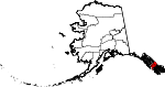
Wrangell-Petersburg Census Area, Alaska
Encyclopedia
U.S. state
A U.S. state is any one of the 50 federated states of the United States of America that share sovereignty with the federal government. Because of this shared sovereignty, an American is a citizen both of the federal entity and of his or her state of domicile. Four states use the official title of...
of Alaska
Alaska
Alaska is the largest state in the United States by area. It is situated in the northwest extremity of the North American continent, with Canada to the east, the Arctic Ocean to the north, and the Pacific Ocean to the west and south, with Russia further west across the Bering Strait...
. It is part of the unorganized borough
Unorganized Borough
The Unorganized Borough is the part of the U.S. state of Alaska not contained in any of its 18 organized boroughs. It encompasses more than half of Alaska's area, , an area larger than any other US state...
and therefore has no borough seat. Its largest community is Petersburg
Petersburg, Alaska
Petersburg is a city in Petersburg Census Area, Alaska, in the United States. According to 2009 Census Bureau estimates, the population of the city is 2,824 full time residents.- History :...
. The population was 6,684 at the 2000 census, at which time it was named the Wrangell-Petersburg Census Area. The name was changed on June 1, 2008, when Wrangell
Wrangell, Alaska
Wrangell is a city and borough in the U.S. state of Alaska. At the 2000 census the population was 2,308.Its Tlingit name is Ḵaachx̱aana.áakʼw . The Tlingit people residing in the Wrangell area, who were there centuries before Europeans, call themselves the Shtaxʼhéen Ḵwáan after the nearby Stikine...
, formerly a part of the census area, was incorporated as a city-and-borough. With the departure of Wrangell, the only other large population center is the city of Kake
Kake, Alaska
Kake is a town in Petersburg Census Area, Alaska, United States. The population was 710 at the 2000 census. The name comes from the Tlingit word or , which is derived from “dawn, daylight” and “mouth”, i.e. “mouth of dawn” or “opening of daylight”.-Geography:Kake is located at...
. A map of the new boundaries can be seen here:
Geography
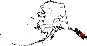
Adjacent boroughs and census areas
- Sitka City and Borough, AlaskaSitka City and Borough, AlaskaThe City and Borough of Sitka, originally called New Archangel under Russian Rule, is a unified city-borough located on Baranof Island and the southern half of Chichagof Island in the Alexander Archipelago of the Pacific Ocean , in the U.S...
- west, northwest - Hoonah-Angoon Census Area, Alaska - northwest, north
- City and Borough of WrangellWrangell, AlaskaWrangell is a city and borough in the U.S. state of Alaska. At the 2000 census the population was 2,308.Its Tlingit name is Ḵaachx̱aana.áakʼw . The Tlingit people residing in the Wrangell area, who were there centuries before Europeans, call themselves the Shtaxʼhéen Ḵwáan after the nearby Stikine...
- southeast - Prince of Wales-Hyder Census Area, Alaska - south
Also shares eastern border with British Columbia
British Columbia
British Columbia is the westernmost of Canada's provinces and is known for its natural beauty, as reflected in its Latin motto, Splendor sine occasu . Its name was chosen by Queen Victoria in 1858...
, Canada
Canada
Canada is a North American country consisting of ten provinces and three territories. Located in the northern part of the continent, it extends from the Atlantic Ocean in the east to the Pacific Ocean in the west, and northward into the Arctic Ocean...
.
- Kitimat-Stikine Regional District, British Columbia - northeast, east
National protected areas
- Alaska Maritime National Wildlife RefugeAlaska Maritime National Wildlife RefugeThe Alaska Maritime National Wildlife Refuge is a United States National Wildlife Refuge comprising 2,400 islands, headlands, rocks, islets, spires and reefs in Alaska, with a total area of , of which is wilderness)...
(part of the Gulf of Alaska unit)- Hazy Islands WildernessHazy Islands WildernessHazy Islands Wilderness is a wilderness area in the U.S. state of Alaska. It was first established as a National Wildlife Refuge in 1912, and officially designated as Wilderness in 1970 by the United States Congress. The islands are part of the Gulf of Alaska unit of the Alaska Maritime National...
- Hazy Islands Wilderness
- Tongass National ForestTongass National ForestThe Tongass National Forest in southeastern Alaska is the largest national forest in the United States at 17 million acres . Most of its area is part of the temperate rain forest WWF ecoregion, itself part of the larger Pacific temperate rain forest WWF ecoregion, and is remote enough to be home...
(part)- Coronation Island WildernessCoronation Island WildernessCoronation Island Wilderness is a wilderness area in the U.S. state of Alaska. It was designated by the United States Congress in 1980. The wilderness area encompasses the entirety of Coronation Island plus the Spanish Islands. It is part of Tongass National Forest, which is managed by the United...
- Kuiu Wilderness
- Petersburg Creek-Duncan Salt Chuck Wilderness
- Stikine-LeConte WildernessStikine-LeConte WildernessThe Stikine-LeConte Wilderness is on the mainland of southeast Alaska, southeast of Petersburg and north of Wrangell, Alaska. The boundary extends from Frederick Sound on the west to the Alaska-Canada boundary on the east. The wilderness is in size...
(part) - Tebenkof Bay Wilderness
- Coronation Island Wilderness
Demographics
As of the censusCensus
A census is the procedure of systematically acquiring and recording information about the members of a given population. It is a regularly occurring and official count of a particular population. The term is used mostly in connection with national population and housing censuses; other common...
of 2000, there were 6,684 people, 2,587 households, and 1,764 families residing in the census area. The population density
Population density
Population density is a measurement of population per unit area or unit volume. It is frequently applied to living organisms, and particularly to humans...
was 1 people per square mile (0/km²). There were 3,284 housing units at an average density of 1/sq mi (0/km²). The racial makeup of the census area was 73.04% White
Race (United States Census)
Race and ethnicity in the United States Census, as defined by the Federal Office of Management and Budget and the United States Census Bureau, are self-identification data items in which residents choose the race or races with which they most closely identify, and indicate whether or not they are...
, 0.22% Black
Race (United States Census)
Race and ethnicity in the United States Census, as defined by the Federal Office of Management and Budget and the United States Census Bureau, are self-identification data items in which residents choose the race or races with which they most closely identify, and indicate whether or not they are...
or African American
Race (United States Census)
Race and ethnicity in the United States Census, as defined by the Federal Office of Management and Budget and the United States Census Bureau, are self-identification data items in which residents choose the race or races with which they most closely identify, and indicate whether or not they are...
, 16.07% Native American
Race (United States Census)
Race and ethnicity in the United States Census, as defined by the Federal Office of Management and Budget and the United States Census Bureau, are self-identification data items in which residents choose the race or races with which they most closely identify, and indicate whether or not they are...
, 1.62% Asian
Race (United States Census)
Race and ethnicity in the United States Census, as defined by the Federal Office of Management and Budget and the United States Census Bureau, are self-identification data items in which residents choose the race or races with which they most closely identify, and indicate whether or not they are...
, 0.13% Pacific Islander
Race (United States Census)
Race and ethnicity in the United States Census, as defined by the Federal Office of Management and Budget and the United States Census Bureau, are self-identification data items in which residents choose the race or races with which they most closely identify, and indicate whether or not they are...
, 1.11% from other races
Race (United States Census)
Race and ethnicity in the United States Census, as defined by the Federal Office of Management and Budget and the United States Census Bureau, are self-identification data items in which residents choose the race or races with which they most closely identify, and indicate whether or not they are...
, and 7.81% from two or more races. 1.97% of the population were Hispanic
Race (United States Census)
Race and ethnicity in the United States Census, as defined by the Federal Office of Management and Budget and the United States Census Bureau, are self-identification data items in which residents choose the race or races with which they most closely identify, and indicate whether or not they are...
or Latino
Race (United States Census)
Race and ethnicity in the United States Census, as defined by the Federal Office of Management and Budget and the United States Census Bureau, are self-identification data items in which residents choose the race or races with which they most closely identify, and indicate whether or not they are...
of any race. 1.46% reported speaking Spanish
Spanish language
Spanish , also known as Castilian , is a Romance language in the Ibero-Romance group that evolved from several languages and dialects in central-northern Iberia around the 9th century and gradually spread with the expansion of the Kingdom of Castile into central and southern Iberia during the...
at home, while 1.12% speak Tlingit
Tlingit language
The Tlingit language ) is spoken by the Tlingit people of Southeast Alaska and Western Canada. It is a branch of the Na-Dené language family. Tlingit is very endangered, with fewer than 140 native speakers still living, all of whom are bilingual or near-bilingual in English...
http://www.mla.org/map_data_results&state_id=2&county_id=280&mode=geographic&zip=&place_id=&cty_id=&ll=&a=&ea=&order=r.
There were 2,587 households out of which 36.70% had children under the age of 18 living with them, 54.30% were married couples
Marriage
Marriage is a social union or legal contract between people that creates kinship. It is an institution in which interpersonal relationships, usually intimate and sexual, are acknowledged in a variety of ways, depending on the culture or subculture in which it is found...
living together, 9.20% had a female householder with no husband present, and 31.80% were non-families. 26.30% of all households were made up of individuals and 7.50% had someone living alone who was 65 years of age or older. The average household size was 2.56 and the average family size was 3.11.
In the census area the population was spread out with 29.70% under the age of 18, 5.70% from 18 to 24, 29.00% from 25 to 44, 26.00% from 45 to 64, and 9.50% who were 65 years of age or older. The median age was 37 years. For every 100 females there were 108.40 males. For every 100 females age 18 and over, there were 107.80 males.
Cities and towns
- KakeKake, AlaskaKake is a town in Petersburg Census Area, Alaska, United States. The population was 710 at the 2000 census. The name comes from the Tlingit word or , which is derived from “dawn, daylight” and “mouth”, i.e. “mouth of dawn” or “opening of daylight”.-Geography:Kake is located at...
- KupreanofKupreanof, AlaskaKupreanof is a city at the eastern shore of Kupreanof Island in the Petersburg Census Area, in the U.S. state of Alaska. The population was 23 at the 2000 census, making it the smallest incorporated city in the state.-Geography:...
- PetersburgPetersburg, AlaskaPetersburg is a city in Petersburg Census Area, Alaska, in the United States. According to 2009 Census Bureau estimates, the population of the city is 2,824 full time residents.- History :...
- Port AlexanderPort Alexander, AlaskaPort Alexander is a city at the southeastern corner of Baranof Island in Petersburg Census Area, Alaska, United States. At the 2000 census the population was 81.-Geography:Port Alexander is located at ....