
Wolseley, South Australia
Encyclopedia
Wolseley is a small South Australia
n town
near the Victorian
border. It is five kilometres south of the Dukes Highway
and 13 kilometres east of Bordertown
. It was first proclaimed a town in 1884.
A broad (1600 mm) gauge railway was opened to Adelaide
and Melbourne
in 1886. Some years later the Millicent
- Mount Gambier
narrow (1067 mm) gauge railway was extended to Wolseley, creating a break-of-gauge
rail junction. In the 1950s the break-of-gauge was abolished by the conversion of the Mount Gambier line to broad gauge. The line to Mount Gambier has been out of use since the conversion of the Adelaide - Melbourne line to standard (1435 mm) gauge in 1995, pending possible conversion to standard gauge.
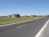
Early in World War II
, No. 12 Inland Aircraft Fuel Depot was established at Wolseley, with an initial capacity of 280,000 gallons (approx 1,273,000 litres) in three tanks camouflaged to look like farm buildings. The depot started operations in 1942 and three additional tanks were added later. It was disbanded on 14 June 1944.
Wolseley is in the Tatiara District Council
, the state electoral district of MacKillop
and the federal
Division of Barker
.
South Australia
South Australia is a state of Australia in the southern central part of the country. It covers some of the most arid parts of the continent; with a total land area of , it is the fourth largest of Australia's six states and two territories.South Australia shares borders with all of the mainland...
n town
Town
A town is a human settlement larger than a village but smaller than a city. The size a settlement must be in order to be called a "town" varies considerably in different parts of the world, so that, for example, many American "small towns" seem to British people to be no more than villages, while...
near the Victorian
Victoria (Australia)
Victoria is the second most populous state in Australia. Geographically the smallest mainland state, Victoria is bordered by New South Wales, South Australia, and Tasmania on Boundary Islet to the north, west and south respectively....
border. It is five kilometres south of the Dukes Highway
Dukes Highway
The Dukes Highway is an important 189 kilometre highway corridor in South Australia which links the Australian cities of Adelaide and Melbourne. It is part of the National Highway system spanning Australia, and is signed as National Highway A8....
and 13 kilometres east of Bordertown
Bordertown, South Australia
Bordertown is a small South Australian town near the Victorian border. It is where the Dukes Highway and the railway line, the two main routes between Adelaide and Melbourne, cross Tatiara Creek....
. It was first proclaimed a town in 1884.
A broad (1600 mm) gauge railway was opened to Adelaide
Adelaide
Adelaide is the capital city of South Australia and the fifth-largest city in Australia. Adelaide has an estimated population of more than 1.2 million...
and Melbourne
Melbourne
Melbourne is the capital and most populous city in the state of Victoria, and the second most populous city in Australia. The Melbourne City Centre is the hub of the greater metropolitan area and the Census statistical division—of which "Melbourne" is the common name. As of June 2009, the greater...
in 1886. Some years later the Millicent
Millicent, South Australia
Millicent is a town in South Australia, south-east of Adelaide, and north of Mount Gambier. At the 2006 Census, the population was 4,771.The town is home to the Millicent National Trust Museum, and is nearby to the Tantanoola Caves Conservation Park and the Canunda National Park.The Millicent...
- Mount Gambier
Mount Gambier, South Australia
Mount Gambier is the largest regional city in South Australia located approximately 450 kilometres south of the capital Adelaide and just 17 kilometres from the Victorian border....
narrow (1067 mm) gauge railway was extended to Wolseley, creating a break-of-gauge
Break-of-gauge
With railways, a break-of-gauge occurs where a line of one gauge meets a line of a different gauge. Trains and rolling stock cannot run through without some form of conversion between gauges, and freight and passengers must otherwise be transloaded...
rail junction. In the 1950s the break-of-gauge was abolished by the conversion of the Mount Gambier line to broad gauge. The line to Mount Gambier has been out of use since the conversion of the Adelaide - Melbourne line to standard (1435 mm) gauge in 1995, pending possible conversion to standard gauge.
Early in World War II
World War II
World War II, or the Second World War , was a global conflict lasting from 1939 to 1945, involving most of the world's nations—including all of the great powers—eventually forming two opposing military alliances: the Allies and the Axis...
, No. 12 Inland Aircraft Fuel Depot was established at Wolseley, with an initial capacity of 280,000 gallons (approx 1,273,000 litres) in three tanks camouflaged to look like farm buildings. The depot started operations in 1942 and three additional tanks were added later. It was disbanded on 14 June 1944.
Wolseley is in the Tatiara District Council
Tatiara District Council
Tatiara District Council is a local government area located in eastern South Australia, about 100 km north of the Limestone Coast. The name Tatiara is said to mean "the good country", a phrase which dates back to the area's first inhabitants. It is also one of the largest local government...
, the state electoral district of MacKillop
Electoral district of MacKillop
MacKillop is an electoral district of the House of Assembly in the Australian state of South Australia. Named in 1991 after Mary MacKillop , who served the local area, it is a 24,358.3 km² rural electorate in the south-east of the state, stretching from the mouth of the Murray River...
and the federal
Australian House of Representatives
The House of Representatives is one of the two houses of the Parliament of Australia; it is the lower house; the upper house is the Senate. Members of Parliament serve for terms of approximately three years....
Division of Barker
Division of Barker
The Division of Barker is an Australian Electoral Division in the south-east of South Australia.The division was created in 1903 and is named for Collet Barker, an early explorer of the region at the mouth of the Murray River...
.