
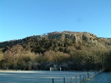
Whitbarrow
Encyclopedia
Whitbarrow is a Site of Special Scientific Interest
and National Nature Reserve
in Cumbria
, and forms part of the Morecambe Bay
Pavements Special Area of Conservation
due to its supporting some of the best European examples of natural limestone
habitats. Also known as Whitbarrow Scar (though properly that term applies to the cliffs lining its western edge), the hill lies about 9 kilometres (5.6 mi) south-west of Kendal
, just north of the A590 road
, close to the village of Witherslack
.
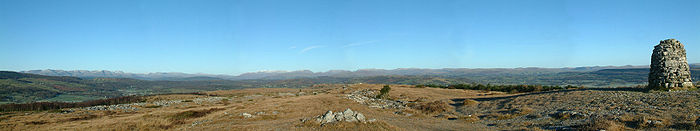
It is a mixture of woodland
, grassland
and limestone pavement
. The hill is prominent from the A590 road
with its steep limestone cliffs, laid down in the Carboniferous
period some 350 million years ago. The main cliff faces are made up of rocks known as Dalton Beds, above which are Urswick Limestones, of which the limestone pavement (here and elsewhere around Morecambe Bay
, including Hutton Roof Crags
) has been formed.
The limestone has been used for many purposes including building, agricultural fertiliser, and production of millstone
s, but is now protected by law and it is an offence to remove any.
Whitbarrow, like most of the Lake District
, shows many signs of the last ice age
, including glacial erratics (boulders left behind when the ice retreated), and the limestone pavement
itself, formed when ice left bare limestone exposed to the elements which eroded it and left us with the grikes and clints we see today.
Much of Whitbarrow is covered in woodland, initially naturally and from 1919 following planting; the Forestry Commission
now holds leases on parts of the hill. A variety of techniques are used to manage the woodland, including coppicing; the variety of methods adds to the range of wildlife resulting.
The summit of Whitbarrow Scar is known as Lord’s Seat, and a walk to here is featured in The Outlying Fells of Lakeland by Alfred Wainwright
.
Site of Special Scientific Interest
A Site of Special Scientific Interest is a conservation designation denoting a protected area in the United Kingdom. SSSIs are the basic building block of site-based nature conservation legislation and most other legal nature/geological conservation designations in Great Britain are based upon...
and National Nature Reserve
National Nature Reserve
For details of National nature reserves in the United Kingdom see:*National Nature Reserves in England*National Nature Reserves in Northern Ireland*National Nature Reserves in Scotland*National Nature Reserves in Wales...
in Cumbria
Cumbria
Cumbria , is a non-metropolitan county in North West England. The county and Cumbria County Council, its local authority, came into existence in 1974 after the passage of the Local Government Act 1972. Cumbria's largest settlement and county town is Carlisle. It consists of six districts, and in...
, and forms part of the Morecambe Bay
Morecambe Bay
Morecambe Bay is a large bay in northwest England, nearly due east of the Isle of Man and just to the south of the Lake District National Park. It is the largest expanse of intertidal mudflats and sand in the United Kingdom, covering a total area of 310 km².-Natural features:The rivers Leven,...
Pavements Special Area of Conservation
Special Area of Conservation
A Special Area of Conservation is defined in the European Union's Habitats Directive , also known as the Directive on the Conservation of Natural Habitats and of Wild Fauna and Flora...
due to its supporting some of the best European examples of natural limestone
Limestone
Limestone is a sedimentary rock composed largely of the minerals calcite and aragonite, which are different crystal forms of calcium carbonate . Many limestones are composed from skeletal fragments of marine organisms such as coral or foraminifera....
habitats. Also known as Whitbarrow Scar (though properly that term applies to the cliffs lining its western edge), the hill lies about 9 kilometres (5.6 mi) south-west of Kendal
Kendal
Kendal, anciently known as Kirkby in Kendal or Kirkby Kendal, is a market town and civil parish within the South Lakeland District of Cumbria, England...
, just north of the A590 road
A590 road
The A590 is a trunk road in southern Cumbria, in the north-west of England. It runs north-east to south-west from M6 junction 36, through the towns of Ulverston and Barrow-in-Furness to terminate at Vickerstown on Walney Island. The road is a mixture of dual carriageway and single carriageway,...
, close to the village of Witherslack
Witherslack
Witherslack is a small village and civil parish in the south of Cumbria. It lies on the north eastern side of Morecambe Bay, England. The eastern side of the village borders Whitbarrow Scar with Yewbarrow, which is a small limestone hill, located in the centre of the villageWitherslack is quite...
.
It is a mixture of woodland
Woodland
Ecologically, a woodland is a low-density forest forming open habitats with plenty of sunlight and limited shade. Woodlands may support an understory of shrubs and herbaceous plants including grasses. Woodland may form a transition to shrubland under drier conditions or during early stages of...
, grassland
Grassland
Grasslands are areas where the vegetation is dominated by grasses and other herbaceous plants . However, sedge and rush families can also be found. Grasslands occur naturally on all continents except Antarctica...
and limestone pavement
Limestone pavement
A limestone pavement is a natural karst landform consisting of a flat, incised surface of exposed limestone that resembles an artificial pavement. The term is mainly used in the UK where many of these landforms have developed distinctive surface patterning resembling block of paving...
. The hill is prominent from the A590 road
A590 road
The A590 is a trunk road in southern Cumbria, in the north-west of England. It runs north-east to south-west from M6 junction 36, through the towns of Ulverston and Barrow-in-Furness to terminate at Vickerstown on Walney Island. The road is a mixture of dual carriageway and single carriageway,...
with its steep limestone cliffs, laid down in the Carboniferous
Carboniferous
The Carboniferous is a geologic period and system that extends from the end of the Devonian Period, about 359.2 ± 2.5 Mya , to the beginning of the Permian Period, about 299.0 ± 0.8 Mya . The name is derived from the Latin word for coal, carbo. Carboniferous means "coal-bearing"...
period some 350 million years ago. The main cliff faces are made up of rocks known as Dalton Beds, above which are Urswick Limestones, of which the limestone pavement (here and elsewhere around Morecambe Bay
Morecambe Bay
Morecambe Bay is a large bay in northwest England, nearly due east of the Isle of Man and just to the south of the Lake District National Park. It is the largest expanse of intertidal mudflats and sand in the United Kingdom, covering a total area of 310 km².-Natural features:The rivers Leven,...
, including Hutton Roof Crags
Hutton Roof Crags
Hutton Roof Crags is a hill in south-eastern Cumbria in north-west England, located near to the village of Hutton Roof. It has extensive areas of limestone pavement as well as grassland and woodland...
) has been formed.
The limestone has been used for many purposes including building, agricultural fertiliser, and production of millstone
Millstone
Millstones or mill stones are used in windmills and watermills, including tide mills, for grinding wheat or other grains.The type of stone most suitable for making millstones is a siliceous rock called burrstone , an open-textured, porous but tough, fine-grained sandstone, or a silicified,...
s, but is now protected by law and it is an offence to remove any.
Whitbarrow, like most of the Lake District
Lake District
The Lake District, also commonly known as The Lakes or Lakeland, is a mountainous region in North West England. A popular holiday destination, it is famous not only for its lakes and its mountains but also for its associations with the early 19th century poetry and writings of William Wordsworth...
, shows many signs of the last ice age
Ice age
An ice age or, more precisely, glacial age, is a generic geological period of long-term reduction in the temperature of the Earth's surface and atmosphere, resulting in the presence or expansion of continental ice sheets, polar ice sheets and alpine glaciers...
, including glacial erratics (boulders left behind when the ice retreated), and the limestone pavement
Limestone pavement
A limestone pavement is a natural karst landform consisting of a flat, incised surface of exposed limestone that resembles an artificial pavement. The term is mainly used in the UK where many of these landforms have developed distinctive surface patterning resembling block of paving...
itself, formed when ice left bare limestone exposed to the elements which eroded it and left us with the grikes and clints we see today.
Much of Whitbarrow is covered in woodland, initially naturally and from 1919 following planting; the Forestry Commission
Forestry Commission
The Forestry Commission is a non-ministerial government department responsible for forestry in Great Britain. Its mission is to protect and expand Britain's forests and woodlands and increase their value to society and the environment....
now holds leases on parts of the hill. A variety of techniques are used to manage the woodland, including coppicing; the variety of methods adds to the range of wildlife resulting.
The summit of Whitbarrow Scar is known as Lord’s Seat, and a walk to here is featured in The Outlying Fells of Lakeland by Alfred Wainwright
Alfred Wainwright
Alfred Wainwright MBE was a British fellwalker, guidebook author and illustrator. His seven-volume Pictorial Guide to the Lakeland Fells, published between 1955 and 1966 and consisting entirely of reproductions of his manuscript, has become the standard reference work to 214 of the fells of the...
.