

Wey and Arun Canal
Encyclopedia
The Wey and Arun Canal is a 23-mile-long (37 km) canal
in the south of England, between the River Wey
at Shalford, Surrey
and the River Arun
at Pallingham, in West Sussex
. The canal comprises parts of two separate undertakings – the northern part of the Arun Navigation, between Pallingham and Newbridge Wharf, which opened in 1787, and the Wey and Arun Junction Canal, which connected the Arun at Newbridge to the Godalming Navigation
near Shalford, south of Guildford
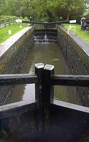
, opened in 1816. The canal was built with 26 locks.
Passing through a rural landscape, there was little freight traffic to justify its continued existence, and the canal was officially abandoned in 1871.
Without maintenance, the canal gradually became derelict over much of its length. However, since 1970, active restoration by The Wey & Arun Canal Trust has resulted in several miles of the waterway being restored to navigable standard. Work is continuing, with the ultimate aim of re-opening the entire canal to navigation.
was used in an unimproved condition for centuries, but work was carried out on the river itself and the port of Arundel
in the 16th century, which allowed boats to reach Pallingham Quay near Pulborough
by 1575. An Act of Parliament
received the Royal Assent
on 13 May 1785, entitled "An Act for amending and improving the Navigation of the River Arun, from Houghton Bridge, in the parish of Houghton, in the county of Sussex, to Pallenham Wharf, in the parish of Wisborough Green, in the said county; and for continuing and extending the Navigation of the said River Arun, from the said Wharf, called Pallenhara Wharf, to a certain Bridge, called New Bridge, situate in the parishes of Pulborough and Wisborough Green, in the said county of Sussex".
 As its name describes, this Act authorised works to improve the Arun upstream from Houghton Bridge (the tidal limit) to Newbridge, near Billingshurst
. The route involved a new artificial cut of 4.5 miles (7.2 km) from Newbridge along the river to Pallingham, crossing the river by an aqueduct
on three strong brick arches at Lordings Lock near Wisborough Green
. An undershot waterwheel of a design unique on the waterway system was built into the aqueduct. Driven by the flow of the river this had scoops on the back of the blades which raised a small proportion of the flowing water into the higher canal. This was completed in 1787. A second artificial cut was added in 1790 from Coldwaltham to Stopham, including a 375-yard (343 m) tunnel under Hardham Hill: this avoided a large bend in the river near Pulborough, saving 5 miles (8 km).
The route of the Navigation from Newbridge to Houghton was 12.25 miles (19.7 km) with six locks. The River continues a further 15.5 miles (25 km) to the sea at Littlehampton
.
The last barge to travel on the section between Pallingham and Newbridge was recorded in 1888, and Hardham tunnel was closed in 1889. The artificial cuts were officially abandoned in 1896, but limited traffic continued on the old river sections into the 20th century, notably bricks from Harwoods Green below Pallingham and chalk from Houghton Bridge: they were finally stopped in 1938 by a new, fixed bridge on the Havant to Brighton railway line
at Ford
.
and the south coast of England, an important consideration as England was at war with France and thus coastal shipping at risk of attack.
Josias Jessop
(son of the more well known William Jessop
) was appointed consulting engineer and made an estimate of £72,217 for construction of the canal, later increased to £86,132 when part of the route was changed.
A survey was carried out in the same year by Francis and Netlam Giles for an alternative route, from the Croydon Canal
to Newbridge, via Merstham
, Three Bridges
, Crawley
and Horsham
.
 An Act of Parliament received the Royal Assent on 19 April 1813, entitled "An Act for making and maintaining a navigable Canal, to unite the Rivers Wey and Arun, in the counties of Surrey and Sussex". This authorised the construction of the canal from the Godalming Navigation (an extension of the River Wey) near Shalford, south of Guildford to the northern terminus of the Arun Navigation at Newbridge. May Upton was appointed resident engineer in July, and work began. Construction was completed in 1816.
The route of the canal was 18.5 miles (29.8 km) with 23 locks.
By the time it was opened, however, the war with France was over and thus one of the key reasons for its construction was removed. As a result it was never very prosperous, but did reasonably well, with a maximum of 23,000 tons
carried in 1839. However, railway competition hit hard in 1865 with the opening of the Guildford and Horsham Railway, which was in direct competition with the canal. There were also engineering problems with few sources of water to tap into, compounded by porous soil on the summit level, which led to water shortages.
An Act of Parliament of 1868 authorised closure. It was offered for sale in 1870, but officially abandoned in 1871, with the land sold to many along its route. After a century of disuse, the canal is being restored by The Wey & Arun Canal Trust.
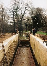
The Trust has reached agreements with several landowners to allow restoration work to be undertaken over half the length of the 23 miles (37 km) canal. By 2005, twelve bridges had been reconstructed, eight locks restored, an aqueduct
re-instated, and several miles of canal bed cleared and dredged.
The Lordings Lock waterwheel was reconstructed by Winston Harwood during the first decade of the 21st century. In 2010 the main spindle of the wheel broke and the wheel was rebuilt to a more effective design.
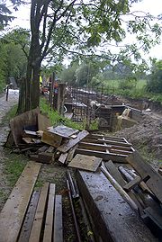
Having completed the multi-million pound B2133 road bridge project (see below), restoration is continuing to move northwards. The newly completed Devil's Hole Lock was reopened in April 2010, and working parties have since concentrated on Southland Lock.
A photo-history of the canal's restoration to date and the latest progress reports may be found on the Trust's website.
 The hump-backed road bridge at Loxwood
was removed and in-filled in 1905, (to be confirmed) severing the canal in two and leaving a major obstacle to restoration. The last boat passed under the bridge in 1869.
Modern regulations prevented the installation of a replacement hump-backed bridge, so restoration required the canal to burrow underneath, leaving the road at its existing level. This was a major engineering exercise, achieved by lowering a 400 m length of canal so that there is adequate headroom for a boat to pass under the road. At the southern end of the length, Brewhurst Lock was reconstructed reducing its fall to 2 feet (0.6 m) from the original drop of 8 feet (2.4 m), and hence lower the level of the water in the pound crossed by the bridge. At the other end, a new lock (Loxwood Lock) was constructed, to provide for the 6 feet (1.8 m) difference between the new and original levels of the canal. In between, the canal bed was lowered by 4.5 ft (1.4 m), the banks shored up with piling, and a new winding hole
created. The new bridge crosses the canal on a skew angle, the resulting 'tunnel' through which the canal passes is 23 metres (25.2 yd) long. The towpath runs through the tunnel, alongside the canal, and also allows pedestrians to cross the road safely; however, the restricted bridge height means horse riders must cross at road level. (Suitable access pathways had to be designed-in as the towpath is a bridleway at this point.) The work was completed, and the first boat passed under the new bridge into the new Loxwood Lock in April 2009. The Canal Trust website includes a comprehensive photo-diary of the construction work.
Canal
Canals are man-made channels for water. There are two types of canal:#Waterways: navigable transportation canals used for carrying ships and boats shipping goods and conveying people, further subdivided into two kinds:...
in the south of England, between the River Wey
River Wey
The River Wey in Surrey, Hampshire and West Sussex is a tributary of the River Thames with two separate branches which join at Tilford. The source of the north branch is at Alton, Hampshire and of the south branch at both Blackdown south of Haslemere, and also close to Gibbet Hill, near Hindhead...
at Shalford, Surrey
Shalford, Surrey
Shalford is a village in Surrey, England, situated on the busy A281 Horsham road immediately south of Guildford. It has a railway station which is between Guildford and Dorking on the North Downs Line....
and the River Arun
River Arun
The Arun is a river in the English county of West Sussex. Its source is a series of small streams in the St Leonard's Forest area, to the east of Horsham...
at Pallingham, in West Sussex
West Sussex
West Sussex is a county in the south of England, bordering onto East Sussex , Hampshire and Surrey. The county of Sussex has been divided into East and West since the 12th century, and obtained separate county councils in 1888, but it remained a single ceremonial county until 1974 and the coming...
. The canal comprises parts of two separate undertakings – the northern part of the Arun Navigation, between Pallingham and Newbridge Wharf, which opened in 1787, and the Wey and Arun Junction Canal, which connected the Arun at Newbridge to the Godalming Navigation
Wey and Godalming Navigations
The Wey and Godalming Navigations is the name given to the navigable parts of the River Wey, in Surrey, UK. The navigation runs for around between the River Thames below Shepperton Lock near Weybridge, to the south-west of London, and the centre of Godalming, in Surrey; it runs through Guildford...
near Shalford, south of Guildford
Guildford
Guildford is the county town of Surrey. England, as well as the seat for the borough of Guildford and the administrative headquarters of the South East England region...
, opened in 1816. The canal was built with 26 locks.
Passing through a rural landscape, there was little freight traffic to justify its continued existence, and the canal was officially abandoned in 1871.
Without maintenance, the canal gradually became derelict over much of its length. However, since 1970, active restoration by The Wey & Arun Canal Trust has resulted in several miles of the waterway being restored to navigable standard. Work is continuing, with the ultimate aim of re-opening the entire canal to navigation.
Arun Navigation
The River ArunRiver Arun
The Arun is a river in the English county of West Sussex. Its source is a series of small streams in the St Leonard's Forest area, to the east of Horsham...
was used in an unimproved condition for centuries, but work was carried out on the river itself and the port of Arundel
Arundel
Arundel is a market town and civil parish in the South Downs of West Sussex in the south of England. It lies south southwest of London, west of Brighton, and east of the county town of Chichester. Other nearby towns include Worthing east southeast, Littlehampton to the south and Bognor Regis to...
in the 16th century, which allowed boats to reach Pallingham Quay near Pulborough
Pulborough
Pulborough is a large village and civil parish in the Horsham district of West Sussex, England, with some 5,000 inhabitants. It is located almost centrally within West Sussex and is south west of London. It is at the junction of the north-south A29 and the east-west roads.The village is near the...
by 1575. An Act of Parliament
Act of Parliament
An Act of Parliament is a statute enacted as primary legislation by a national or sub-national parliament. In the Republic of Ireland the term Act of the Oireachtas is used, and in the United States the term Act of Congress is used.In Commonwealth countries, the term is used both in a narrow...
received the Royal Assent
Royal Assent
The granting of royal assent refers to the method by which any constitutional monarch formally approves and promulgates an act of his or her nation's parliament, thus making it a law...
on 13 May 1785, entitled "An Act for amending and improving the Navigation of the River Arun, from Houghton Bridge, in the parish of Houghton, in the county of Sussex, to Pallenham Wharf, in the parish of Wisborough Green, in the said county; and for continuing and extending the Navigation of the said River Arun, from the said Wharf, called Pallenhara Wharf, to a certain Bridge, called New Bridge, situate in the parishes of Pulborough and Wisborough Green, in the said county of Sussex".
Billingshurst
Billingshurst is a village and civil parish in the Horsham District of West Sussex, England. It lies thirteen kilometres south-west of Horsham, and nine kilometres north-east of Pulborough....
. The route involved a new artificial cut of 4.5 miles (7.2 km) from Newbridge along the river to Pallingham, crossing the river by an aqueduct
Aqueduct
An aqueduct is a water supply or navigable channel constructed to convey water. In modern engineering, the term is used for any system of pipes, ditches, canals, tunnels, and other structures used for this purpose....
on three strong brick arches at Lordings Lock near Wisborough Green
Wisborough Green
Wisborough Green is a village and civil parish in the Chichester district of West Sussex, England miles west of Billingshurst on the A272.Newbridge where the A272 crosses the River Arun mile east of the village was the highest point of the Arun navigation, and the southern end of the Wey and Arun...
. An undershot waterwheel of a design unique on the waterway system was built into the aqueduct. Driven by the flow of the river this had scoops on the back of the blades which raised a small proportion of the flowing water into the higher canal. This was completed in 1787. A second artificial cut was added in 1790 from Coldwaltham to Stopham, including a 375-yard (343 m) tunnel under Hardham Hill: this avoided a large bend in the river near Pulborough, saving 5 miles (8 km).
The route of the Navigation from Newbridge to Houghton was 12.25 miles (19.7 km) with six locks. The River continues a further 15.5 miles (25 km) to the sea at Littlehampton
Littlehampton
Littlehampton is a seaside resort town and civil parish in the Arun District of West Sussex, England, on the east bank at the mouth of the River Arun. It lies south southwest of London, west of Brighton and east of the county town of Chichester....
.
The last barge to travel on the section between Pallingham and Newbridge was recorded in 1888, and Hardham tunnel was closed in 1889. The artificial cuts were officially abandoned in 1896, but limited traffic continued on the old river sections into the 20th century, notably bricks from Harwoods Green below Pallingham and chalk from Houghton Bridge: they were finally stopped in 1938 by a new, fixed bridge on the Havant to Brighton railway line
West Coastway Line
The West Coastway Line is a railway line in England, along the south coast of West Sussex and Hampshire, between Brighton and Southampton, plus the short branches to Littlehampton and Bognor Regis....
at Ford
Ford, West Sussex
Ford is a village and civil parish in the Arun District of West Sussex, England. It is located 3 km to the south-west of Arundel...
.
Wey and Arun Junction Canal
In 1810, the 3rd Earl of Egremont began to promote the idea of a canal to link the Rivers Wey and Arun, separated by only 15 miles (24 km). Part of the justification for this canal through a very rural area, with few of the cargoes which had made other canals profitable, was to provide an inland route from London to PortsmouthLondon to Portsmouth canal
The London to Portsmouth canal was a proposal for the construction of a secure inland canal route from the capital London to the headquarters of the Royal Navy at Portsmouth. It would have allowed craft to move between the two without having to venture into the English Channel and possibly...
and the south coast of England, an important consideration as England was at war with France and thus coastal shipping at risk of attack.
Josias Jessop
Josias Jessop
Josias Jessop was a noted canal engineer, and second son of William Jessop.In 1802 he and his father were appointed engineers of the proposed Croydon, Merstham and Godstone Railway....
(son of the more well known William Jessop
William Jessop
William Jessop was an English civil engineer, best known for his work on canals, harbours and early railways in the late 18th and early 19th centuries.-Early life:...
) was appointed consulting engineer and made an estimate of £72,217 for construction of the canal, later increased to £86,132 when part of the route was changed.
A survey was carried out in the same year by Francis and Netlam Giles for an alternative route, from the Croydon Canal
Croydon Canal
The Croydon Canal ran from Croydon, via Forest Hill, to the Grand Surrey Canal at New Cross in south London, England. It opened in 1809, and closed in 1836, making it the first canal to be formally abandoned by an Act of Parliament.-History:...
to Newbridge, via Merstham
Merstham
Merstham is a village in the Reigate and Banstead borough of Surrey, England, in the London commuter belt. It is just north of Redhill, near the intersection of the M25 and M23 motorways, on the edge of the North Downs and on the North Downs Way.-History:...
, Three Bridges
Three Bridges
Three Bridges is a neighbourhood within the town of Crawley, in the county of West Sussex in England.-History:Three Bridges was a tiny hamlet, which first began to grow with the coming of the London and Brighton Railway in 1841...
, Crawley
Crawley
Crawley is a town and local government district with Borough status in West Sussex, England. It is south of Charing Cross, north of Brighton and Hove, and northeast of the county town of Chichester, covers an area of and had a population of 99,744 at the time of the 2001 Census.The area has...
and Horsham
Horsham
Horsham is a market town with a population of 55,657 on the upper reaches of the River Arun in the centre of the Weald, West Sussex, in the historic County of Sussex, England. The town is south south-west of London, north-west of Brighton and north-east of the county town of Chichester...
.
The route of the canal was 18.5 miles (29.8 km) with 23 locks.
By the time it was opened, however, the war with France was over and thus one of the key reasons for its construction was removed. As a result it was never very prosperous, but did reasonably well, with a maximum of 23,000 tons
Long ton
Long ton is the name for the unit called the "ton" in the avoirdupois or Imperial system of measurements, as used in the United Kingdom and several other Commonwealth countries. It has been mostly replaced by the tonne, and in the United States by the short ton...
carried in 1839. However, railway competition hit hard in 1865 with the opening of the Guildford and Horsham Railway, which was in direct competition with the canal. There were also engineering problems with few sources of water to tap into, compounded by porous soil on the summit level, which led to water shortages.
An Act of Parliament of 1868 authorised closure. It was offered for sale in 1870, but officially abandoned in 1871, with the land sold to many along its route. After a century of disuse, the canal is being restored by The Wey & Arun Canal Trust.
Restoration
In 1970, a group of enthusiasts formed the Wey & Arun Canal Society, with a view to reopening the canal. The Society evolved into The Wey & Arun Canal Trust, the present custodians of the canal restoration, in 1973.The Trust has reached agreements with several landowners to allow restoration work to be undertaken over half the length of the 23 miles (37 km) canal. By 2005, twelve bridges had been reconstructed, eight locks restored, an aqueduct
Aqueduct
An aqueduct is a water supply or navigable channel constructed to convey water. In modern engineering, the term is used for any system of pipes, ditches, canals, tunnels, and other structures used for this purpose....
re-instated, and several miles of canal bed cleared and dredged.
The Lordings Lock waterwheel was reconstructed by Winston Harwood during the first decade of the 21st century. In 2010 the main spindle of the wheel broke and the wheel was rebuilt to a more effective design.
Having completed the multi-million pound B2133 road bridge project (see below), restoration is continuing to move northwards. The newly completed Devil's Hole Lock was reopened in April 2010, and working parties have since concentrated on Southland Lock.
A photo-history of the canal's restoration to date and the latest progress reports may be found on the Trust's website.
The B2133 Bridge
Loxwood
Loxwood is a small village and civil parish in the Chichester district of West Sussex, England, within the Low Weald. The Wey and Arun Canal passes to the East and South of the village....
was removed and in-filled in 1905, (to be confirmed) severing the canal in two and leaving a major obstacle to restoration. The last boat passed under the bridge in 1869.
Modern regulations prevented the installation of a replacement hump-backed bridge, so restoration required the canal to burrow underneath, leaving the road at its existing level. This was a major engineering exercise, achieved by lowering a 400 m length of canal so that there is adequate headroom for a boat to pass under the road. At the southern end of the length, Brewhurst Lock was reconstructed reducing its fall to 2 feet (0.6 m) from the original drop of 8 feet (2.4 m), and hence lower the level of the water in the pound crossed by the bridge. At the other end, a new lock (Loxwood Lock) was constructed, to provide for the 6 feet (1.8 m) difference between the new and original levels of the canal. In between, the canal bed was lowered by 4.5 ft (1.4 m), the banks shored up with piling, and a new winding hole
Winding hole
A winding hole is a widened area of a canal , used for turning a canal boat such as a narrowboat. "Winding" is pronounced as in a flow of air, not as in to rotate.-Etymology:...
created. The new bridge crosses the canal on a skew angle, the resulting 'tunnel' through which the canal passes is 23 metres (25.2 yd) long. The towpath runs through the tunnel, alongside the canal, and also allows pedestrians to cross the road safely; however, the restricted bridge height means horse riders must cross at road level. (Suitable access pathways had to be designed-in as the towpath is a bridleway at this point.) The work was completed, and the first boat passed under the new bridge into the new Loxwood Lock in April 2009. The Canal Trust website includes a comprehensive photo-diary of the construction work.
See also
- River ArunRiver ArunThe Arun is a river in the English county of West Sussex. Its source is a series of small streams in the St Leonard's Forest area, to the east of Horsham...
- River WeyRiver WeyThe River Wey in Surrey, Hampshire and West Sussex is a tributary of the River Thames with two separate branches which join at Tilford. The source of the north branch is at Alton, Hampshire and of the south branch at both Blackdown south of Haslemere, and also close to Gibbet Hill, near Hindhead...
- Portsmouth and Arundel CanalPortsmouth and Arundel CanalThe Portsmouth and Arundel Canal was a canal in the south of England that ran between Portsmouth and Arundel, it was built in 1823 but was never a financial success and was abandoned in 1855, the company was wound up in 1888...
- the two canals were intended to give secure inland navigation between London and the important naval base at PortsmouthPortsmouthPortsmouth is the second largest city in the ceremonial county of Hampshire on the south coast of England. Portsmouth is notable for being the United Kingdom's only island city; it is located mainly on Portsea Island...
External links
- The Wey & Arun Canal Trust – restoration news and detailed maps of the canal's route
- The Wey & Arun Junction Canal