
River Wey
Encyclopedia
The River Wey in Surrey
, Hampshire
and West Sussex
is a tributary of the River Thames
with two separate branches which join at Tilford
. The source of the north branch is at Alton, Hampshire
and of the south branch at both Blackdown
south of Haslemere
, and also close to Gibbet Hill, near Hindhead
(the south branch splits into two smaller rivers). The Wey has a total catchment area of 904 square kilometres (349 sq mi), draining parts of Surrey
, Hampshire
and West Sussex
. It is partly navigable from Godalming, forming the natural part of the Wey and Godalming Navigations
. It joins the River Thames near Weybridge
, which is named after the river, just downstream of Shepperton Lock
. The river is also a popular subject to study, as its features allow for easy access to data.
, turning southwards at Farnham
to Tilford. The catchment of this branch was originally the upper catchment of the Blackwater
, which then ran northwards through what is now Farnham. The Wey captured the Blackwater near Tilford; the capture extended downstream to Farnham, thus reversing the flow to southwards between Farnham and Tilford. The Blackwater remains as a much shorter river to the north of Farnham, with a wind gap (empty valley) between it and the Wey.
and runs through Liphook
, Bramshott
, Bordon
, Lindford
and Frensham
to Tilford. The other rises at Inval, near Gibbet Hill, Hindhead
. This joins the Blackdown-source south branch near Haslemere
. Other smaller tributaries of the south branch are Cooper's Stream and the River Slea.
, Eashing
, Godalming
, Peasmarsh
, Shalford
, Guildford
, Old Woking
, Pyrford
, Byfleet
, Addlestone
and Weybridge
. From Godalming the river is intertwined with the Wey and Godalming Navigations
.
The River Ock
joins at Godalming, Cranleigh Waters
and the River Tillingbourne
at Shalford and the Hoe Stream at Woking.
The 19½ mile towpath of the navigable section is open to walkers.
 During the seventeenth century the river was made navigable to Guildford
and extended in the eighteenth century to Godalming
. The Basingstoke Canal
and Wey and Arun Junction Canal were later connected to the river. The navigable sections are now owned by the National Trust
.
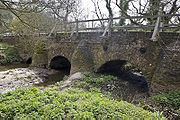
The river has long been used as a source of power for mills, and many are recorded in the Domesday Book
. At one point there were 22 mills on the river, and more on its tributaries. At various times they have been used for grinding grains, fulling wool, rolling oats, crushing cattle cake, leather dressing, paper production and gunpowder manufacture. Willey Mill was still in use in 1953.
Town Mill since at least 1649. From 1770, an additional water wheel
was being used to pump water to the town reservoir on Pewley Down. This was replaced by two water turbine
s in 1896, then a single turbine in 1930, in use until 1952 when itself replaced by electric pumps nearby. In 2003, Guildford Borough Council arranged for the refurbishment and installation of an identical turbine as an example of renewable energy
. Rather than pumping water, this turbine drives a generator to supply up to 260,000 kWH of electricity into the National Grid, annually. The turbine came on-line in 2006. (The 1930 turbine has since been preserved, and may be viewed at Dapdune Wharf
).
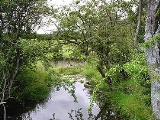
. The river passes through a variety of habitats including heathland, woodland and watermeadow, resulting in a broad diversity of wildlife. There are numerous Sites of Special Scientific Interest (SSSI)
and Nature Reserves
along the river. There are many angling clubs along the river, and healthy stocks of many species of fish including Chub, Barbel, Roach, Pike, Bream, Carp, Perch and Eels.
Surrey
Surrey is a county in the South East of England and is one of the Home Counties. The county borders Greater London, Kent, East Sussex, West Sussex, Hampshire and Berkshire. The historic county town is Guildford. Surrey County Council sits at Kingston upon Thames, although this has been part of...
, Hampshire
Hampshire
Hampshire is a county on the southern coast of England in the United Kingdom. The county town of Hampshire is Winchester, a historic cathedral city that was once the capital of England. Hampshire is notable for housing the original birthplaces of the Royal Navy, British Army, and Royal Air Force...
and West Sussex
West Sussex
West Sussex is a county in the south of England, bordering onto East Sussex , Hampshire and Surrey. The county of Sussex has been divided into East and West since the 12th century, and obtained separate county councils in 1888, but it remained a single ceremonial county until 1974 and the coming...
is a tributary of the River Thames
River Thames
The River Thames flows through southern England. It is the longest river entirely in England and the second longest in the United Kingdom. While it is best known because its lower reaches flow through central London, the river flows alongside several other towns and cities, including Oxford,...
with two separate branches which join at Tilford
Tilford
Tilford is a small village about two miles south of Farnham in Surrey, England. It lies within the Surrey Hills Area of Outstanding Natural Beauty- History :The name "Tilford" is probably derived from "Tila's ford" or "Tilla's ford"....
. The source of the north branch is at Alton, Hampshire
Alton, Hampshire
Alton is a historic market town and civil parish in the East Hampshire district of the English county of Hampshire. It had a population of 16,584 at the 1991 census and is administered by East Hampshire district council. It is located on the source of the River Wey and is the highest town in...
and of the south branch at both Blackdown
Blackdown
- Places :In England:* Blackdown, Dorset, a village near Chard* Blackdown, Hampshire, a village near Winchester* Blackdown, West Sussex, a hill also spelt Black Down* Blackdown, Warwickshire, a village near Leamington Spa...
south of Haslemere
Haslemere
Haslemere is a town in Surrey, England, close to the border with both Hampshire and West Sussex. The major road between London and Portsmouth, the A3, lies to the west, and a branch of the River Wey to the south. Haslemere is approximately south-west of Guildford.Haslemere is surrounded by hills,...
, and also close to Gibbet Hill, near Hindhead
Hindhead
Hindhead is a village in Surrey, England, about 11 miles south-west of Guildford. Neighbouring settlements include Haslemere, Grayshott and Beacon Hill. Hindhead is the highest village in Surrey...
(the south branch splits into two smaller rivers). The Wey has a total catchment area of 904 square kilometres (349 sq mi), draining parts of Surrey
Surrey
Surrey is a county in the South East of England and is one of the Home Counties. The county borders Greater London, Kent, East Sussex, West Sussex, Hampshire and Berkshire. The historic county town is Guildford. Surrey County Council sits at Kingston upon Thames, although this has been part of...
, Hampshire
Hampshire
Hampshire is a county on the southern coast of England in the United Kingdom. The county town of Hampshire is Winchester, a historic cathedral city that was once the capital of England. Hampshire is notable for housing the original birthplaces of the Royal Navy, British Army, and Royal Air Force...
and West Sussex
West Sussex
West Sussex is a county in the south of England, bordering onto East Sussex , Hampshire and Surrey. The county of Sussex has been divided into East and West since the 12th century, and obtained separate county councils in 1888, but it remained a single ceremonial county until 1974 and the coming...
. It is partly navigable from Godalming, forming the natural part of the Wey and Godalming Navigations
Wey and Godalming Navigations
The Wey and Godalming Navigations is the name given to the navigable parts of the River Wey, in Surrey, UK. The navigation runs for around between the River Thames below Shepperton Lock near Weybridge, to the south-west of London, and the centre of Godalming, in Surrey; it runs through Guildford...
. It joins the River Thames near Weybridge
Weybridge
Weybridge is a town in the Elmbridge district of Surrey in South East England. It is bounded to the north by the River Thames at the mouth of the River Wey, from which it gets its name...
, which is named after the river, just downstream of Shepperton Lock
Shepperton Lock
Shepperton Lock is a lock on the River Thames, in England adjoining the northern bank near Shepperton, Surrey . It is across the river from Weybridge, but not directly accessible from there....
. The river is also a popular subject to study, as its features allow for easy access to data.
Wey North
The Wey North branch rises in Alton in Hampshire and runs eastwards through Upper Froyle and BentleyBentley, Hampshire
Bentley is a village and civil parish in the East Hampshire district of Hampshire, England. The parish has an acreage of . The village is located just off the A31 road between Farnham in Surrey and Alton, being about five miles west of Farnham and six miles east of Alton...
, turning southwards at Farnham
Farnham
Farnham is a town in Surrey, England, within the Borough of Waverley. The town is situated some 42 miles southwest of London in the extreme west of Surrey, adjacent to the border with Hampshire...
to Tilford. The catchment of this branch was originally the upper catchment of the Blackwater
River Blackwater (River Loddon)
The River Blackwater is a tributary of the River Loddon in England and, indirectly, of the River Thames. It rises at Rowhill on the outskirts of Aldershot between Aldershot in Hampshire and Farnham in Surrey and runs northwards to join the Loddon near the village of Swallowfield in Berkshire...
, which then ran northwards through what is now Farnham. The Wey captured the Blackwater near Tilford; the capture extended downstream to Farnham, thus reversing the flow to southwards between Farnham and Tilford. The Blackwater remains as a much shorter river to the north of Farnham, with a wind gap (empty valley) between it and the Wey.
Wey South
The Wey South branch commences in two shorter rivers leading from separate sources. One is at Black Down near HaslemereHaslemere
Haslemere is a town in Surrey, England, close to the border with both Hampshire and West Sussex. The major road between London and Portsmouth, the A3, lies to the west, and a branch of the River Wey to the south. Haslemere is approximately south-west of Guildford.Haslemere is surrounded by hills,...
and runs through Liphook
Liphook
Liphook is a large village in the East Hampshire district of Hampshire, England. It is 4.1 miles west of Haslemere, on the A3 road, and lies on the Hampshire/West Sussex border.Liphook has its own railway station, on the Portsmouth Direct Line....
, Bramshott
Bramshott
Bramshott is a village in the East Hampshire district of Hampshire, England. It lies 0.9 miles north of Liphook.-Overview:The nearest railway station is 1.3 miles south of the village, at Liphook....
, Bordon
Bordon
Bordon is a town in the East Hampshire district of Hampshire, England. It lies 5.4 miles southeast of Alton and forms a part of the civil parish of Whitehill, the adjoining village. Both settlements are on the A325 road and close to the A3 road between London and Portsmouth...
, Lindford
Lindford
Lindford is a village and civil parish in the East Hampshire district of Hampshire, England. It is 1.1 miles northeast of Bordon, on the B3004 road.The nearest railway station is Liphook, 3.8 miles southeast of the village....
and Frensham
Frensham
Frensham is a village in Surrey, England, beside the A287, south west of Guildford. Neighbouring villages include Millbridge, Shortfield Common, Dockenfield, Spreakley, Batt's Corner and Rushmoor. Frensham lies on the River Wey. Farnham is the nearest main town and it is to the north. The...
to Tilford. The other rises at Inval, near Gibbet Hill, Hindhead
Hindhead
Hindhead is a village in Surrey, England, about 11 miles south-west of Guildford. Neighbouring settlements include Haslemere, Grayshott and Beacon Hill. Hindhead is the highest village in Surrey...
. This joins the Blackdown-source south branch near Haslemere
Haslemere
Haslemere is a town in Surrey, England, close to the border with both Hampshire and West Sussex. The major road between London and Portsmouth, the A3, lies to the west, and a branch of the River Wey to the south. Haslemere is approximately south-west of Guildford.Haslemere is surrounded by hills,...
. Other smaller tributaries of the south branch are Cooper's Stream and the River Slea.
Wey combined
From Tilford the river runs by ElsteadElstead
Elstead is a village in Surrey, England, with shops and cottages mainly clustered around a central green, close to the River Wey. Neighbouring villages include Gatwick , Puttenham, Charleshill and Peper Harow...
, Eashing
Eashing
Eashing is a small village in Surrey a couple of miles outside Godalming and was once part of the Godalming but is now administered by Guildford Borough Council. The village is divided into Upper and Lower Eashing. During the reign of King Alfred the Great a burgh was constructed at Upper Eashing...
, Godalming
Godalming
Godalming is a town and civil parish in the Waverley district of the county of Surrey, England, south of Guildford. It is built on the banks of the River Wey and is a prosperous part of the London commuter belt. Godalming shares a three-way twinning arrangement with the towns of Joigny in France...
, Peasmarsh
Peasmarsh
For other uses of Peasmarsh see Peasmarsh Peasmarsh is a village and civil parish in East Sussex in England. It is located on the A268 road between Rye and Beckley, some three miles north-west of Rye....
, Shalford
Shalford, Surrey
Shalford is a village in Surrey, England, situated on the busy A281 Horsham road immediately south of Guildford. It has a railway station which is between Guildford and Dorking on the North Downs Line....
, Guildford
Guildford
Guildford is the county town of Surrey. England, as well as the seat for the borough of Guildford and the administrative headquarters of the South East England region...
, Old Woking
Old Woking
Old Woking is a former village now considered part of the town of Woking, Surrey, and is located 2.5 miles to the southeast of Woking town centre. Woking Palace was important in the times of Henry VIII. The James Walker factory has been redeveloped into a dense residential housing estate....
, Pyrford
Pyrford
Pyrford is an English village that for centuries had historical links with the monastery of Westminster, in whose possession it remained between the Norman Conquest and the Dissolution of the Monasteries nearly five hundred years later. It is thirty miles by road from central London and situated...
, Byfleet
Byfleet
Byfleet is an inland island village forming a suburb of Woking in Surrey, England. It is in the east of the borough between the River Wey and the River Mole, and is within the M25 motorway....
, Addlestone
Addlestone
Addlestone is a town in the borough of Runnymede in the county of Surrey, England.Immediate surrounding towns and villages include Weybridge, Ottershaw, Chertsey, and New Haw. It is near Junction 11 of the M25 motorway and is served by Addlestone railway station on the Chertsey Branch Line. It also...
and Weybridge
Weybridge
Weybridge is a town in the Elmbridge district of Surrey in South East England. It is bounded to the north by the River Thames at the mouth of the River Wey, from which it gets its name...
. From Godalming the river is intertwined with the Wey and Godalming Navigations
Wey and Godalming Navigations
The Wey and Godalming Navigations is the name given to the navigable parts of the River Wey, in Surrey, UK. The navigation runs for around between the River Thames below Shepperton Lock near Weybridge, to the south-west of London, and the centre of Godalming, in Surrey; it runs through Guildford...
.
The River Ock
River Ock, Surrey
The River Ock is a tributary of the River Wey in Surrey, England.The river rises near Hambledon and then flows north between Enton and Witley, then past Wheelerstreet and Milford. It is then joined by a tributary which flows through Busbridge Lakes. It then passes through Ockford, named for the...
joins at Godalming, Cranleigh Waters
Cranleigh Waters
The Cranleigh Waters or Bramley Wey is a tributary of the River Wey in Surrey. It rises near Walliswood, flowing initially southwestwards to Vachery Pond, before turning to run northwards via Bramley to meet the Wey at Shalford....
and the River Tillingbourne
River Tillingbourne
The River Tillingbourne runs along the south side of the North Downs and joins the River Wey at Guildford. Its source is near Tilling Springs to the north of Leith Hill at and it runs through Friday Street, Abinger Hammer, Gomshall, Shere, Albury, Chilworth and Shalford. The source is a...
at Shalford and the Hoe Stream at Woking.
The 19½ mile towpath of the navigable section is open to walkers.
History
Guildford
Guildford is the county town of Surrey. England, as well as the seat for the borough of Guildford and the administrative headquarters of the South East England region...
and extended in the eighteenth century to Godalming
Godalming
Godalming is a town and civil parish in the Waverley district of the county of Surrey, England, south of Guildford. It is built on the banks of the River Wey and is a prosperous part of the London commuter belt. Godalming shares a three-way twinning arrangement with the towns of Joigny in France...
. The Basingstoke Canal
Basingstoke Canal
The Basingstoke Canal is a British Canal, completed in 1794, built to connect Basingstoke with the River Thames at Weybridge via the Wey Navigation....
and Wey and Arun Junction Canal were later connected to the river. The navigable sections are now owned by the National Trust
National Trust for Places of Historic Interest or Natural Beauty
The National Trust for Places of Historic Interest or Natural Beauty, usually known as the National Trust, is a conservation organisation in England, Wales and Northern Ireland...
.
The river has long been used as a source of power for mills, and many are recorded in the Domesday Book
Domesday Book
Domesday Book , now held at The National Archives, Kew, Richmond upon Thames in South West London, is the record of the great survey of much of England and parts of Wales completed in 1086...
. At one point there were 22 mills on the river, and more on its tributaries. At various times they have been used for grinding grains, fulling wool, rolling oats, crushing cattle cake, leather dressing, paper production and gunpowder manufacture. Willey Mill was still in use in 1953.
Guildford Town Mill
There has been a mill on the site of GuildfordGuildford
Guildford is the county town of Surrey. England, as well as the seat for the borough of Guildford and the administrative headquarters of the South East England region...
Town Mill since at least 1649. From 1770, an additional water wheel
Water wheel
A water wheel is a machine for converting the energy of free-flowing or falling water into useful forms of power. A water wheel consists of a large wooden or metal wheel, with a number of blades or buckets arranged on the outside rim forming the driving surface...
was being used to pump water to the town reservoir on Pewley Down. This was replaced by two water turbine
Water turbine
A water turbine is a rotary engine that takes energy from moving water.Water turbines were developed in the 19th century and were widely used for industrial power prior to electrical grids. Now they are mostly used for electric power generation. They harness a clean and renewable energy...
s in 1896, then a single turbine in 1930, in use until 1952 when itself replaced by electric pumps nearby. In 2003, Guildford Borough Council arranged for the refurbishment and installation of an identical turbine as an example of renewable energy
Renewable energy
Renewable energy is energy which comes from natural resources such as sunlight, wind, rain, tides, and geothermal heat, which are renewable . About 16% of global final energy consumption comes from renewables, with 10% coming from traditional biomass, which is mainly used for heating, and 3.4% from...
. Rather than pumping water, this turbine drives a generator to supply up to 260,000 kWH of electricity into the National Grid, annually. The turbine came on-line in 2006. (The 1930 turbine has since been preserved, and may be viewed at Dapdune Wharf
Dapdune Wharf
Dapdune Wharf is a former wharf on the Wey and Godalming Navigations in Guildford, England, UK, close to the Surrey County Cricket Club ground. It is now maintained by the National Trust....
).
Natural environment
Much of the upper reaches of the river is within the Surrey Hills Area of Outstanding Natural BeautySurrey Hills AONB
The Surrey Hills is a Area of Outstanding Natural Beauty , located in Surrey, England. The AONB was designated in 1958 and covers one quarter of the county of Surrey...
. The river passes through a variety of habitats including heathland, woodland and watermeadow, resulting in a broad diversity of wildlife. There are numerous Sites of Special Scientific Interest (SSSI)
Site of Special Scientific Interest
A Site of Special Scientific Interest is a conservation designation denoting a protected area in the United Kingdom. SSSIs are the basic building block of site-based nature conservation legislation and most other legal nature/geological conservation designations in Great Britain are based upon...
and Nature Reserves
Nature reserve
A nature reserve is a protected area of importance for wildlife, flora, fauna or features of geological or other special interest, which is reserved and managed for conservation and to provide special opportunities for study or research...
along the river. There are many angling clubs along the river, and healthy stocks of many species of fish including Chub, Barbel, Roach, Pike, Bream, Carp, Perch and Eels.
Further reading
- Inland Waterways Association (South-East Region) The River Wey and Godalming Navigation: Weybridge to Godalming Inland Waterways Association 1976
See also
- Tributaries of the River ThamesTributaries of the River ThamesThis article lists the tributaries of the River Thames, in England. It also includes significant backwaters and waterways which also have confluences with the main stream of the River Thames.Most of the tributaries are natural, but a few were man-made...
- Canals of the United KingdomCanals of the United KingdomThe canals of the United Kingdom are a major part of the network of inland waterways in the United Kingdom. They have a colourful history, from use for irrigation and transport, through becoming the focus of the Industrial Revolution, to today's role for recreational boating...
- List of rivers in England
- Perseverance IVPerseverance IVPerseverance IV is a preserved Wey barge, moored at Dapdune Wharf on the River Wey. She was the final barge to leave the historic yards at Dapdune, Guildford, in 1966...
, last floating River Wey barge.