

Western Province (Kenya)
Encyclopedia
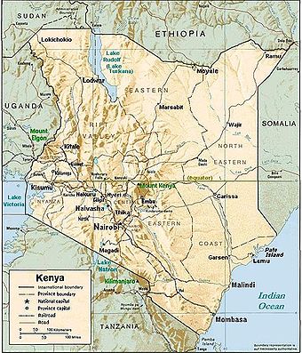
Kenya
Kenya , officially known as the Republic of Kenya, is a country in East Africa that lies on the equator, with the Indian Ocean to its south-east...
, bordering Uganda
Uganda
Uganda , officially the Republic of Uganda, is a landlocked country in East Africa. Uganda is also known as the "Pearl of Africa". It is bordered on the east by Kenya, on the north by South Sudan, on the west by the Democratic Republic of the Congo, on the southwest by Rwanda, and on the south by...
, is one of Kenya's seven administrative provinces outside Nairobi
Nairobi
Nairobi is the capital and largest city of Kenya. The city and its surrounding area also forms the Nairobi County. The name "Nairobi" comes from the Maasai phrase Enkare Nyirobi, which translates to "the place of cool waters". However, it is popularly known as the "Green City in the Sun" and is...
. It is west of the Eastern Rift Valley and is inhabited mainly by the Luhya people. Quakerism
Religious Society of Friends
The Religious Society of Friends, or Friends Church, is a Christian movement which stresses the doctrine of the priesthood of all believers. Members are known as Friends, or popularly as Quakers. It is made of independent organisations, which have split from one another due to doctrinal differences...
is widely practised here
Quakers in Kenya
There are about 157,000 members of the Religious Society of Friends, or Quakers, in Africa. African Friends make up around 46% of Friends internationally, the largest proportion in any one continent...
. Kenya's second highest mountain, Mount Elgon
Mount Elgon
Mount Elgon is an extinct shield volcano on the border of Uganda and Kenya, north of Kisumu and west of Kitale.- Physical features :It is the oldest and largest solitary volcano in East Africa, covering an area of around 3500 km²....
is located in Bungoma District
Bungoma District
Bungoma District is a district in the Western Province of Kenya. Its capital town is Bungoma. It has a population of 876,491 and an area of 2,069 km².The economy of Bungoma district is mainly agricultural, centering on the sugar cane and maize industries...
. The Kakamega Forest
Kakamega Forest
Kakamega Forest is situated in Western Province Kenya, north-west of the capital Nairobi, and near to the border with Uganda. It is said to be Kenya's last remnant of the ancient Guineo-Congolian rainforest that once spanned the continent....
rainforest is part of the area. The province capital is the town of Kakamega
Kakamega
Kakamega is a town in western Kenya lying about 30 km north of the Equator. It is the headquarters of . The town has a population of 73,607 ....
. In 1999 the total population was of 3,358,776 inhabitants within an area of 8,361 km².
Geography
Western Province has diverse physical features, from the hills of northern Bungoma district to the plains bordering Lake VictoriaLake Victoria
Lake Victoria is one of the African Great Lakes. The lake was named for Queen Victoria of the United Kingdom, by John Hanning Speke, the first European to discover this lake....
in Busia District
Busia District, Kenya
Busia is a district in the Western Province of Kenya. It borders Kakamega District to the east, Bungoma District and Teso district to the north, Busia District, Uganda to the west, and Lake Victoria to the south....
. The highest point in Western Province is the peak of Mount Elgon
Mount Elgon
Mount Elgon is an extinct shield volcano on the border of Uganda and Kenya, north of Kisumu and west of Kitale.- Physical features :It is the oldest and largest solitary volcano in East Africa, covering an area of around 3500 km²....
, while the lowest point is the town of Busia
Busia town
Busia town may refer to:* Busia, Uganda, a town in Uganda at the border with Kenya* Busia, Kenya, a town in Kenya at the border with Uganda...
on the water at Lake Victoria
Lake Victoria
Lake Victoria is one of the African Great Lakes. The lake was named for Queen Victoria of the United Kingdom, by John Hanning Speke, the first European to discover this lake....
.
Climate
The climate is mainly tropicalTropical climate
A tropical climate is a climate of the tropics. In the Köppen climate classification it is a non-arid climate in which all twelve months have mean temperatures above...
, with variations due to altitude. Kakamega district is mainly hot and wet most of the year, while Bungoma district is colder but just as wet. Busia district is the warmest, while the hilly Vihiga District is the coldest. The entire province experiences very heavy rainfall all year round, with the long rains in the earlier months of the year.
Economy
Farming is the main economic activity in the province.Bungoma district is sugar country, with one of the country's largest sugar factories, as well as numerous small-holder sugar mills. Maize
Maize
Maize known in many English-speaking countries as corn or mielie/mealie, is a grain domesticated by indigenous peoples in Mesoamerica in prehistoric times. The leafy stalk produces ears which contain seeds called kernels. Though technically a grain, maize kernels are used in cooking as a vegetable...
is also grown for subsistence, alongside pearl millet
Pearl millet
Pearl millet is the most widely grown type of millet. Grown in Africa and the Indian subcontinent since prehistoric times, it is generally accepted that pearl millet originated in Africa and was subsequently introduced into India. The center of diversity, and suggested area of domestication, for...
and sorghum
Sorghum
Sorghum is a genus of numerous species of grasses, one of which is raised for grain and many of which are used as fodder plants either cultivated or as part of pasture. The plants are cultivated in warmer climates worldwide. Species are native to tropical and subtropical regions of all continents...
. Dairy farming is widely practised, as well as the raising of poultry. There is a small but important tourist circuit, centering on the biennial circumcision ceremonies.
Kakamega district has a mixture of both subsistence and cash crop farming, with sugar cane being the preferred medium to large scale crop. The district has two sugar factories. There is also a significant tourism industry centering on Kakamega Forest.
Busia district experiences perennial floods from the Nzoia River
Nzoia River
The Nzoia River is a 160-mile long Kenyan river, rising from Mount Elgon. It flows south and then west, eventually flowing into Lake Victoria near the town of Port Victoria....
, and the dominant economic activity is fishing on Lake Victoria. Limited commercial farming is also practiced, mainly of sugar cane. Subsistence farming of cassava
Cassava
Cassava , also called yuca or manioc, a woody shrub of the Euphorbiaceae native to South America, is extensively cultivated as an annual crop in tropical and subtropical regions for its edible starchy tuberous root, a major source of carbohydrates...
is widely practiced.
Vihiga district has large tea
Tea
Tea is an aromatic beverage prepared by adding cured leaves of the Camellia sinensis plant to hot water. The term also refers to the plant itself. After water, tea is the most widely consumed beverage in the world...
plantations, and is the most densely populated rural area in Kenya. Quarrying for construction materials is a significant activity in the hilly district. Dairy farming is also widely practiced in Vihiga.
Western Kenya has many large factories, including sugar processing plants (4 factories). The largest of these is Mumias Sugar, based at Mumias
Mumias
Mumias is a town in the Western Province of Kenya. The town has an urban population of 32.965 Mumias is the center of the Mumias Division of the Butere/Mumias District. The town is linked by road to Kakamega , Busia , Bungoma , Butere . The village of Buchinga is located between Mumias and...
, to the west of Kakamega. This factory produces the dominant sugar brand in Kenya and is an economic success story. Also in Western Kenya is the largest paper factory in Africa (Pan Paper Mills in Webuye
Webuye
Webuye is an industrial town in Bungoma District in the Western Province of Kenya. Located on the main road to Uganda, the town is home to the Pan African Paper Mills, the largest paper factory in the region, as well as a number of heavy-chemical and sugar manufacturers. It has a tropical climate,...
) and chemical processors. Despite this, living standards are generally low and social amenities like running water and electricity are not available to the majority of the province's residents.
Districts
District :Bungoma
Bungoma District
Bungoma District is a district in the Western Province of Kenya. Its capital town is Bungoma. It has a population of 876,491 and an area of 2,069 km².The economy of Bungoma district is mainly agricultural, centering on the sugar cane and maize industries...
Busia
Busia District, Kenya
Busia is a district in the Western Province of Kenya. It borders Kakamega District to the east, Bungoma District and Teso district to the north, Busia District, Uganda to the west, and Lake Victoria to the south....
Butere/Mumias
Butere/Mumias District
Butere/Mumias District is an administrative district in the Western Province of Kenya. Its capital town is Butere. The district has a population of 476,928 and an area of 939 km² .The district has four constituencies:*Butere Constituency...
Kakamega
Kakamega District
Kakamega District is a district in the Western Province of Kenya. Its capital town is Kakamega. It has a population of 603,422 and an area of 1,395 km² .The district has four constituencies:*Malava Constituency*Lurambi Constituency...
Lugari
Lugari District
Lugari District is one of the seventy-one districts of Kenya, located in that country's Western Province. Its capital is Lugari.- Lugari District :Lugari District has a population of 215,920 and an area of 670 km² ....
Mount Elgon
Mount Elgon District
Mount Elgon District is an administrative district in the Western Province of Kenya. Its capital town is Kapsokwony.-Geography and demographics:The district is located on southeastern slopes of Mount Elgon...
Teso
Teso District, Kenya
Teso District is an administrative district in the Western Province of Kenya. Its capital town is Amagoro, next to Malaba a border town between Kenya and Uganda. The district has a population of 181,491 and an area of . The district has one electoral constituency, Amagoro Constituency . Alupe...
Vihiga
Vihiga District
Vihiga District is an administrative district in the Western Province of Kenya. Its capital town is Mbale, which is located in Vihiga Division. The district has a population of 498,883 and an area of 563 km²...
Districts after 2007
Several new districts were created in 2007 in Kenya, also in Western Province :| District | Capital |
|---|---|
| Bumula | |
| Bungoma Central | Chwele Chwele Chwele is a town in the Western Province of Kenya. The town is an agricultural marketing centre located between Kimilili and Bungoma. The market is the major meeting point for farmers from the surrounding areas of Mt. Elgon, Namwela, Sirisia, Lurende,[Matibo] and Chebukaka especially every Monday... |
| Bungoma East (Webuye) | Webuye Webuye Webuye is an industrial town in Bungoma District in the Western Province of Kenya. Located on the main road to Uganda, the town is home to the Pan African Paper Mills, the largest paper factory in the region, as well as a number of heavy-chemical and sugar manufacturers. It has a tropical climate,... |
| Bungoma North | Mukuyuni |
| Bungoma South | Bungoma Bungoma Bungoma is a town in Western Province of Kenya, bordered by Uganda in the west. Bungoma town was established as a trading centre in the early 20th century. The town is the headquarters of Kenya's Bungoma District and it hosts a municipal council... |
| Bungoma West (Sirisia) | Sirisia |
| Bunyala | Budalangi |
| Busia Busia District, Kenya Busia is a district in the Western Province of Kenya. It borders Kakamega District to the east, Bungoma District and Teso district to the north, Busia District, Uganda to the west, and Lake Victoria to the south.... |
Busia Busia town Busia town may refer to:* Busia, Uganda, a town in Uganda at the border with Kenya* Busia, Kenya, a town in Kenya at the border with Uganda... |
| Kisumu Butere | Butere Butere Butere is a town in the Western Province of Kenya. It has an urban population of 8636 The town is the capital of Butere District formerly Butere/Mumias District.-Transportation Links:... |
| Emuhaya | Kima |
| Hamisi | Hamisi |
| Kakamega Central (Lurambi) | |
| Kakamega East (Shinyalu) | |
| Kakamega North (Malava) | Malava |
| Kakamega South (Ikolomani) | Kakamega Kakamega Kakamega is a town in western Kenya lying about 30 km north of the Equator. It is the headquarters of . The town has a population of 73,607 .... |
| Khwisero | Khwisero |
| Kimilili | Kimilili Kimilili Kimilili is a town and area in Kenya's Bungoma District. The area is occupied mainly by the Bukusu and Sabaot communities. Its proximity to the fertile slopes of Mt Elgon, on the Kenya-Uganda border, has made it a trading center for agricultural goods and services... |
| Lugari Lugari District Lugari District is one of the seventy-one districts of Kenya, located in that country's Western Province. Its capital is Lugari.- Lugari District :Lugari District has a population of 215,920 and an area of 670 km² .... |
Lumakanda |
| Matete | Matete Matete Matete is a municipality in the Mont Amba district of Kinshasa, the capital city of the Democratic Republic of the Congo.... |
| Matungu | Matungu Matungu Matungu is a small town in the Western Province of Kenya. It is located in the Butere/Mumias District.The Matungu Constituency carved our of the larger Mumias constituency in 1997. It was created following complaints by a section of residents of Mumias that they felt unrepresented due to the large... |
| Mount Elgon Mount Elgon District Mount Elgon District is an administrative district in the Western Province of Kenya. Its capital town is Kapsokwony.-Geography and demographics:The district is located on southeastern slopes of Mount Elgon... |
Kapsokwony Kapsokwony Kapsokwony is a small town in Mount Elgon District of Western Province , Kenya. The town is part of Mount Elgon County Council and Mount Elgon Constituency.... |
| Mumias | Mumias Mumias Mumias is a town in the Western Province of Kenya. The town has an urban population of 32.965 Mumias is the center of the Mumias Division of the Butere/Mumias District. The town is linked by road to Kakamega , Busia , Bungoma , Butere . The village of Buchinga is located between Mumias and... |
| Sabatia | Sabatia |
| Samia | Funyala |
| Siaya Siaya District Siaya District is one of the twelve districts that make up Nyanza Province in the southwest part of Kenya. It is bordered by Busia District to the North, Vihiga and Butere/Mumias Districts to the North-East, Bondo District to the South, and Kisumu District to the South-East. The total area of the... |
Siaya Siaya Siaya is a town in Nyanza Province of Kenya. It is the capital of Siaya District. It is located 50 kilometres Northwest of Kisumu, the provincial capital. Siaya forms munipical council with population of 41,174, of whom 13,787 are classified urban .... |
| Teso North | Amagoro Amagoro Amagoro is a town in the Western Province of Kenya. It is situated approximately 7 kilometres from the border of Uganda. It is the capital town of the Teso District.... |
| Teso South | Amukura |
| Vihiga Vihiga District Vihiga District is an administrative district in the Western Province of Kenya. Its capital town is Mbale, which is located in Vihiga Division. The district has a population of 498,883 and an area of 563 km²... |
Mbale Mbale, Kenya Mbale town is the headquarter of Vihiga County in western Kenya. It is also called Maragoli, which is the name of the indigineus inhabitants of the area, and is home to the annual Maragoli Cultural Festival which is held every 26 December.... |