

Western Coal Fields
Encyclopedia
Kentucky
The Commonwealth of Kentucky is a state located in the East Central United States of America. As classified by the United States Census Bureau, Kentucky is a Southern state, more specifically in the East South Central region. Kentucky is one of four U.S. states constituted as a commonwealth...
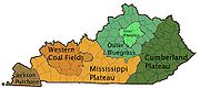
compose an area in the west-central part of the state, bounded by the Dripping Springs Escarpment. This area is bordered on three sides by the Pennyroyal Plateau
Pennyroyal Plateau
The Pennyroyal Plateau, or, as it is more commonly called in Kentucky, the Pennyrile, is a large area of the state that features rolling hills, caves, and karst topography in general. It is also called the "Mississippi Plateau"....
and to the north by the Ohio River
Ohio River
The Ohio River is the largest tributary, by volume, of the Mississippi River. At the confluence, the Ohio is even bigger than the Mississippi and, thus, is hydrologically the main stream of the whole river system, including the Allegheny River further upstream...
. It is characterized by Pennsylvanian
Pennsylvanian
The Pennsylvanian is, in the ICS geologic timescale, the younger of two subperiods of the Carboniferous Period. It lasted from roughly . As with most other geochronologic units, the rock beds that define the Pennsylvanian are well identified, but the exact date of the start and end are uncertain...
age sandstone
Sandstone
Sandstone is a sedimentary rock composed mainly of sand-sized minerals or rock grains.Most sandstone is composed of quartz and/or feldspar because these are the most common minerals in the Earth's crust. Like sand, sandstone may be any colour, but the most common colours are tan, brown, yellow,...
s, shale
Shale
Shale is a fine-grained, clastic sedimentary rock composed of mud that is a mix of flakes of clay minerals and tiny fragments of other minerals, especially quartz and calcite. The ratio of clay to other minerals is variable. Shale is characterized by breaks along thin laminae or parallel layering...
s and coal
Coal
Coal is a combustible black or brownish-black sedimentary rock usually occurring in rock strata in layers or veins called coal beds or coal seams. The harder forms, such as anthracite coal, can be regarded as metamorphic rock because of later exposure to elevated temperature and pressure...
seams. Nearly all of the counties in the area are part of the Kentucky-Illinois-Indiana Tri-State Area.
Included areas
The Western Coal Field region of Kentucky includes all of the following counties:- Butler CountyButler County, KentuckyButler County is a county located in the US state of Kentucky. It was formed in 1810, becoming Kentucky's 53rd county. As of 2000, the population was 13,010. Its county seat is Morgantown, Kentucky. Butler is a prohibition or dry county.- History :...
- Daviess CountyDaviess County, KentuckyAs of the census of 2000, there were 91,545 people, 36,033 households, and 24,826 families residing in the county. The population density was . There were 38,432 housing units at an average density of...
- Grayson CountyGrayson County, KentuckyGrayson County is a county located in the U.S. state of Kentucky. It was formed in 1810. As of 2000, the population was 24,053. Its county seat is Leitchfield. The county is named for William Grayson , a Revolutionary War colonel and a prominent Virginia political figure...
- Hancock CountyHancock County, KentuckyHancock County is a county located in the U.S. state of Kentucky. It was formed in 1829. As of 2000, the population was 8,392. It is included in the Owensboro, Kentucky, Metropolitan Statistical Area. Its county seat is Hawesville. The county is named for John Hancock...
- Henderson CountyHenderson County, KentuckyHenderson County is a county located in the U.S. state of Kentucky. It was formed in 1799. As the latest census data update of 2010, the population was counted 46,250. The county seat is the City of Henderson. The county was named for Colonel Richard Henderson who originally purchased of land...
- Hopkins CountyHopkins County, KentuckyHopkins County is a county located in the U.S. state of Kentucky. It was formed in 1807. As of 2000, the population was 46,519. Its county seat is Madisonville. The county is named for General Samuel Hopkins, an officer in both the Revolutionary War and War of 1812, and later a Kentucky legislator...
- McLean CountyMcLean County, KentuckyMcLean County is a county located in the U.S. state of Kentucky; its population was 9,938 in the 2000 Census. McLean County's county seat is at Calhoun....
- Muhlenberg CountyMuhlenberg County, KentuckyMuhlenberg County is a county located in the U.S. state of Kentucky. As of the 2010 Census, the population was 31,499. The county is named for Peter Muhlenberg. Its county seat is Greenville....
- Ohio CountyOhio County, KentuckyOhio County is a county located in the U.S. state of Kentucky. As of 2000, the population was 22,916. Its county seat is Hartford. The county is named for the Ohio River, which originally formed its northern boundary. It is a dry county, which means that the sale of alcohol is restricted or...
- Union CountyUnion County, KentuckyUnion County is a county located in the U.S. state of Kentucky. It was formed in 1811. As of 2010, the population was 15,007. Its county seat is Morganfield.-Geography:Union County is part of the Western Coal Fields region of Kentucky...
- Webster CountyWebster County, KentuckyWebster County is a county located in the U.S. state of Kentucky. Webster County was formed in 1860 from parts of the counties of Henderson, Hopkins, and Union. As of 2000, the population is 14,120. Its county seat is Dixon. The county was named for American statesman Daniel Webster...
Additionally, the region includes parts of the following counties:
- Breckinridge CountyBreckinridge County, KentuckyAs of the census of 2000, there were 18,648 people, 7,324 households, and 5,309 families residing in the county. The population density was . There were 9,890 housing units at an average density of...
- Christian CountyChristian County, KentuckyChristian County is a county located in the U.S. state of Kentucky. It was formed in 1797. As of 2000, its population was 72,265. Its county seat is Hopkinsville, Kentucky...
- Edmonson CountyEdmonson County, KentuckyEdmonson County is a county located in the U.S. state of Kentucky. It was formed in 1826. As of 2007, the population was 11,978. It is included in the Bowling Green Metropolitan Statistical Area. Its county seat is Brownsville...
- Hart CountyHart County, KentuckyHart County is a county located in the U.S. state — or, more correctly, "Commonwealth" — of Kentucky. It was formed in 1819. , the population was 17,445. Its county seat is Munfordville. The county is named for Captain Nathaniel G. S. Hart, a Kentucky militia officer in the War of 1812...
- Logan CountyLogan County, KentuckyLogan County is a county located in the southwest area of the U.S. state of Kentucky. As of 2000, the population was 26,573. Its county seat is Russellville...
- Todd CountyTodd County, KentuckyTodd County is a county located in the U.S. state of Kentucky. As of 2000, the population is 11,971. Its county seat is Elkton. The county is named after Colonel John Todd, who was killed at the Battle of Blue Licks in 1782...
- Warren CountyWarren County, KentuckyWarren County is a county located in the U.S. state of Kentucky, specifically the Pennyroyal Plateau and Western Coal Fields regions. It is included in the Bowling Green, Kentucky, Metropolitan Statistical Area. The population was 113,792 in the 2010 Census. The county seat is Bowling Green...
Not all these counties, and not all of the Western Coal Field, contain coal. The term is used to define the region with Pennyslvanian-age strata, largely sandstone and shale, in contrast to the Mississippian-age limestone
Limestone
Limestone is a sedimentary rock composed largely of the minerals calcite and aragonite, which are different crystal forms of calcium carbonate . Many limestones are composed from skeletal fragments of marine organisms such as coral or foraminifera....
of the adjoining and older Pennyroyal
Pennyroyal
Pennyroyal refers to two plants in the mint family, Lamiaceae. For the American species, see American pennyroyal. The European pennyroyal, Mentha pulegium, , is a plant in the mint genus, within the family Lamiaceae. Crushed Pennyroyal leaves exhibit a very strong fragrance similar to spearmint...
region. A transitional zone, generally defined as being part of the coalfield region, is the Clifty Area, where the rock outcrops include bituminous sandstone, or tar sands, which have commercial value as paving material.
The biggest concentration of surface mines in this region has historically been along the edges in Hopkins, Muhlenberg, and Ohio Counties. All three counties still contain a very large amount of coal and have active mining, surface and underground, operations taking place. The use of power shovels and draglines were very common in these counties where the coal would lay as close as 60–80 feet from the surface. This is a region that was considered to be the largest producer of coal in the world throughout the 1960s through part of the 80s until it dramatically dropped in the early 90s after the passage of clean air regulations. The largest mining company found during the 30 year span of prosperity became Peabody Coal Company ( Peabody Energy
Peabody Energy
Peabody Energy Corporation , previously Peabody Coal Company, is the largest private-sector coal company in the world. The company is headquartered in Downtown St. Louis, Missouri....
) who's Corporate Office's were located in the region in Henderson, KY at the time. Eventually enough regulation, government intervention, and political debate shut this region down economically starting in 1987. In 2003 Armstrong Coal Company started to lease a large chunk of property in the region from Peabody Energy so that they could recover the coal. The reason for this is the demand for Western Kentucky Coal has once again spiked to levels not seen since the 1970s.