
West Lomond
Encyclopedia
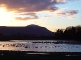
West Lomond is the highest point in the county of Fife
, Scotland
and the highest peak in the Lomond Hills
. Its volcanic dolerite cone rises above an escarpment
of carboniferous sandstone
and limestone
layers. The conspicuous peaks of West Lomond, and its neighbour East Lomond, are visible for many miles around, which explains their name, the 'Lomond' or 'Beacon' hills.
West Lomond is usually climbed from Craigmead car park on the Falkland
-Leslie road, as this sits at a height of almost 300 metres. From the car park, leave the trees by a wishing gate, and follow a broad grassy path roughly north-west which joins a track after about 320 metres. Follow this track and subsequent path, which has recently been re-laid to limit erosion, all the way to the summit cone of West Lomond. On reaching the base of this cone, one has the choice of two possible routes of ascent. One path zigzags steeply up the eastern (near) face of the hill, whilst the other, the easier route, skirts round to the north of the peak, before climbing up the far side to the summit. As the hill's prominence would suggest, one obtains a fantastic panorama from its summit, not only of the surrounding countryside, but of the greater part of the Central Belt
, as well as the Southern Highlands and the Grampian Mountains. On the summit are the remains of an Iron Age
Hill fort
.
Another route of ascent leaves from the Bunnet Stane
and climbs diagonally up the steep north slopes of the escarpment to a gap in the cliffs, above which one gains the plateau
a short distance from the summit cone. On this route there are more interesting features to the landscape, however the climb is steeper and begins at a much lesser altitude than the Craigmead car park.
Fife
Fife is a council area and former county of Scotland. It is situated between the Firth of Tay and the Firth of Forth, with inland boundaries to Perth and Kinross and Clackmannanshire...
, Scotland
Scotland
Scotland is a country that is part of the United Kingdom. Occupying the northern third of the island of Great Britain, it shares a border with England to the south and is bounded by the North Sea to the east, the Atlantic Ocean to the north and west, and the North Channel and Irish Sea to the...
and the highest peak in the Lomond Hills
Lomond Hills
The Lomond Hills , also known as the Paps of Fife lie in the centre of Fife, Scotland. At 522m West Lomond is the highest point in the county of Fife.-Natural geography:...
. Its volcanic dolerite cone rises above an escarpment
Escarpment
An escarpment is a steep slope or long cliff that occurs from erosion or faulting and separates two relatively level areas of differing elevations.-Description and variants:...
of carboniferous sandstone
Sandstone
Sandstone is a sedimentary rock composed mainly of sand-sized minerals or rock grains.Most sandstone is composed of quartz and/or feldspar because these are the most common minerals in the Earth's crust. Like sand, sandstone may be any colour, but the most common colours are tan, brown, yellow,...
and limestone
Limestone
Limestone is a sedimentary rock composed largely of the minerals calcite and aragonite, which are different crystal forms of calcium carbonate . Many limestones are composed from skeletal fragments of marine organisms such as coral or foraminifera....
layers. The conspicuous peaks of West Lomond, and its neighbour East Lomond, are visible for many miles around, which explains their name, the 'Lomond' or 'Beacon' hills.
West Lomond is usually climbed from Craigmead car park on the Falkland
Falkland, Fife
Falkland is a town and former royal burgh, formerly known as the Parish of Kilgour c1300AD in Fife, Scotland at the foot of the Lomond Hills.According to the 2008 population estimate, the village has a population of 1,180.- History :...
-Leslie road, as this sits at a height of almost 300 metres. From the car park, leave the trees by a wishing gate, and follow a broad grassy path roughly north-west which joins a track after about 320 metres. Follow this track and subsequent path, which has recently been re-laid to limit erosion, all the way to the summit cone of West Lomond. On reaching the base of this cone, one has the choice of two possible routes of ascent. One path zigzags steeply up the eastern (near) face of the hill, whilst the other, the easier route, skirts round to the north of the peak, before climbing up the far side to the summit. As the hill's prominence would suggest, one obtains a fantastic panorama from its summit, not only of the surrounding countryside, but of the greater part of the Central Belt
Central Belt
The Central Belt of Scotland is a common term used to describe the area of highest population density within Scotland. Despite the name, it is not geographically central but is nevertheless situated at the 'waist' of Scotland on a conventional map and the term 'central' is used in many local...
, as well as the Southern Highlands and the Grampian Mountains. On the summit are the remains of an Iron Age
Iron Age
The Iron Age is the archaeological period generally occurring after the Bronze Age, marked by the prevalent use of iron. The early period of the age is characterized by the widespread use of iron or steel. The adoption of such material coincided with other changes in society, including differing...
Hill fort
Hill fort
A hill fort is a type of earthworks used as a fortified refuge or defended settlement, located to exploit a rise in elevation for defensive advantage. They are typically European and of the Bronze and Iron Ages. Some were used in the post-Roman period...
.
Another route of ascent leaves from the Bunnet Stane
Bunnet Stane
The Bunnet Stane is a rock formation near the hamlet of Gateside in Fife. It sits upon one of the calciferous sandstone outcrops that exist around the base of the Lomond Hills. The Bunnet Stane itself consists of an elevated table of rock, about ten feet by twenty feet across, which sits upon a...
and climbs diagonally up the steep north slopes of the escarpment to a gap in the cliffs, above which one gains the plateau
Plateau
In geology and earth science, a plateau , also called a high plain or tableland, is an area of highland, usually consisting of relatively flat terrain. A highly eroded plateau is called a dissected plateau...
a short distance from the summit cone. On this route there are more interesting features to the landscape, however the climb is steeper and begins at a much lesser altitude than the Craigmead car park.