
.gif)
Wales Island (British Columbia)
Encyclopedia
Wales Island is an island on the North Coast of British Columbia
, Canada
, situated east of the Dixon Entrance
at the entrance to Portland Inlet
.
35 square miles (90.6 km²) in area, Wales Island is 30 miles (48.3 km) north of the port city of Prince Rupert, and 55 miles (88.5 km) south-east of Ketchikan, Alaska
.
Wales Island is bounded on the north by the Pearse Canal
and Wales Passage, and by Tongass Passage
and Portland Inlet
to the south. The international boundary between Alaska
and British Columbia bisects Pearse Canal over a distance of 25 miles (40.2 km), such that the view from the north-west shore of Wales Island looks out over Alaska, specifically, Fillmore Island
in the Misty Fjords National Monument
. Within Canada, Pearse Island
lies to the northeast.
In August of 1793, during his exploration of the west coast of North America in HMS Discovery
, Captain George Vancouver named Wales Point, at the entrance to Portland Inlet, after William Wales
, master of the Royal Mathematical School
at Christ's Hospital
, London. Both Wales and Vancouver had accompanied Captain James Cook on his second circumnavigation of the globe in HMS Resolution
, 1772-75. At the time, George Vancouver was a young midshipman, and William Wales was the ship’s astronomer. Vancouver later credited Wales with teaching him the necessary navigational skills which enabled his own explorations of the Pacific region in the early 1790s. Vancouver also accompanied Captain Cook on his third and final voyage, 1776-79.
In 1871, an official at the British Hydrographic Office named Wales Island in association with the point of land named 78 years earlier by Captain Vancouver.
between Canada and the United States. This dispute had its roots in the 1825 treaty signed by Russia and Great Britain, which attempted to define, in principle more than fact, the boundary that lay between Alaska and what was then the west coast of British North America
. Included in the terms of this treaty was the stipulation that the southernmost boundary of Alaskan territory would advance northwards through Portland Canal to the 56th parallel north
. This demarcation was claimed to have placed Wales Island firmly in Alaskan territory.
 There the matter lay until Russia sold Alaska to the United States in 1867, and British Columbia became a province of Canada four years later, in 1871. Between this period and the final settlement of the boundary question in 1903, survey crews from both Canada and the United States actively explored, mapped and charted the high mountains, deep fjords, glaciers and bogland of this rugged terrain, often in collaboration. In 1896, the military intervened in the form of the United States Army Corps of Engineers
, which constructed four stone houses in the Portland Canal area. This was done to strengthen America’s claim to the Canal as the southernmost boundary of Alaska. One of these sturdy structures was built on the south shore of Wales Island, while another, on the border between Stewart, BC and Hyder, Alaska
, can still be seen today.
Two years later, the potential mineral wealth of the far north, as revealed by the Klondike Gold Rush
of 1898, convinced both Canada and the United States that a new Alaska boundary treaty was urgently required.
This renewed interest in the region led eventually to the signing of the Hay-Herbert Treaty
in January, 1903. The terms of the treaty provided for a tribunal to settle the boundary question in precise geographical language. Thus, over the next several months, the Alaska Boundary Tribunal, with Canadian, American and British representatives, duly measured, mapped and deliberated, before delivering its award in October of that year. Among the many consequences of this final demarcation of the boundaries of the Alaskan Panhandle was the result that Wales Island now belonged to British Columbia.
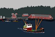
In 1902, while Wales Island was still claimed to be in U.S. territory, a salmon cannery was built on the east shore of Pearse Canal, on the north-west side of the island. But as a result of the 1903 Tribunal Award, the American owners of the cannery forfeited possession of their facility, which by then had produced more than 3500 cases of canned salmon.
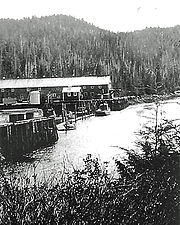 At the same time, Hidden Inlet Cannery, situated 14 miles (22.5 km) further north on the west shore of Pearse Canal, had suffered a reverse fate, and was now in Alaskan territory. In 1910, Merrill DesBrisay, the former Canadian owner of Hidden Inlet Cannery purchased Wales Island Cannery and rebuilt it. For the next 14 years, DesBrisay and Company operated the plant before selling to the Canadian Fishing Company in 1925. Wales Island Cannery had its peak production of 50,000 cases of salmon in the 1924 season. It produced its final pack of 26,000 cases in 1949, the last of eleven canneries to operate in the Nass River
-Portland Canal area. For several years thereafter, the plant functioned as a summer gillnet station before being abandoned in the late 1950s. Today, a fly-in fishing lodge occupies the site of the former Wales Island Cannery.
Coda: In 1936, the U.S. Congress granted $100,000 to the former American owners of Wales Island Cannery, as compensation for the loss of their property 33 years earlier.
in the south. Hecate Lowland terrain is generally rough and rocky, with wide areas of muskeg wetland and bog forest. Tree species include western red cedar, yellow cedar, mountain hemlock and fir. Salal, ferns, berry bush and skunk cabbage are commonly found undergrowth. Lowland climate in the Wales Island region is dominated by frontal flows from Dixon Entrance
, resulting in frequent wind storms and heavy rainfall.
Waterfowl are found in abundance throughout the protected inlets and estuaries that indent Wales Island’s coastline of 33 miles (53.1 km). Species include murre, grebe, murrelet, gull, tern, loon, auklet, petrel and eagle. The island’s topography affords a profusion of breeding and nesting habitat for a wide variety of seabirds, and is an integral component of the Pacific coast migratory flyway.
British Columbia Coast
The British Columbia Coast or BC Coast is Canada's western continental coastline on the Pacific Ocean. The usage is synonymous with the term West Coast of Canada....
, Canada
Canada
Canada is a North American country consisting of ten provinces and three territories. Located in the northern part of the continent, it extends from the Atlantic Ocean in the east to the Pacific Ocean in the west, and northward into the Arctic Ocean...
, situated east of the Dixon Entrance
Dixon Entrance
The Dixon Entrance is a strait about long and wide in the Pacific Ocean at the International Boundary between the U.S. state of Alaska and the province of British Columbia in Canada. It was named by Joseph Banks for Captain George Dixon, a Royal Navy officer, fur trader, and explorer, who...
at the entrance to Portland Inlet
Portland Inlet
Portland Inlet is an inlet of the Pacific Ocean on the coast of British Columbia, Canada, approximately 55 kilometers north of Prince Rupert, British Columbia. It joins the Chatham Sound opposite the Dixon Entrance. It is 40 kilometers long and as much as 13 kilometers wide...
.
35 square miles (90.6 km²) in area, Wales Island is 30 miles (48.3 km) north of the port city of Prince Rupert, and 55 miles (88.5 km) south-east of Ketchikan, Alaska
Ketchikan, Alaska
Ketchikan is a city in Ketchikan Gateway Borough, Alaska, United States, the southeasternmost sizable city in that state. With an estimated population of 7,368 in 2010 within the city limits, it is the fifth most populous city in the state....
.
Wales Island is bounded on the north by the Pearse Canal
Pearse Canal
Pearse Canal is a channel or strait forming part of the Canada-United States border at the southern end of the Alaska Panhandle and adjacent to the mouth of Portland Inlet. It is on the northwest side of Wales and Pearse Islands, which are in British Columbia, Canada, and forms part of the...
and Wales Passage, and by Tongass Passage
Tongass Passage
Tongass Passage is a strait on the Canada-United States border between Alaska and British Columbia, located on the southwest side of Wales Island. Wales Island, and Pearse Island, to its northeast, were claimed by the United States prior to the settlement of the Alaska boundary dispute in 1903. ...
and Portland Inlet
Portland Inlet
Portland Inlet is an inlet of the Pacific Ocean on the coast of British Columbia, Canada, approximately 55 kilometers north of Prince Rupert, British Columbia. It joins the Chatham Sound opposite the Dixon Entrance. It is 40 kilometers long and as much as 13 kilometers wide...
to the south. The international boundary between Alaska
Alaska
Alaska is the largest state in the United States by area. It is situated in the northwest extremity of the North American continent, with Canada to the east, the Arctic Ocean to the north, and the Pacific Ocean to the west and south, with Russia further west across the Bering Strait...
and British Columbia bisects Pearse Canal over a distance of 25 miles (40.2 km), such that the view from the north-west shore of Wales Island looks out over Alaska, specifically, Fillmore Island
Fillmore Island
Fillmore Island is an island in Southeast Alaska, U.S.A. The island lies between Fillmore Inlet and Pearse Canal. The island was charted by George Vancouver in 1793, who sailed around it and proved its insular nature. It was named in 1885 by the U.S. Coast and Geodetic Survey after Ensign John...
in the Misty Fjords National Monument
Misty Fjords National Monument
Misty Fiords National Monument is a National Monument and Wilderness Area administered by the US Department of Agriculture United States Forest Service 40 miles east of Ketchikan, Alaska, along the Inside Passage coast in extreme southeastern Alaska and covering 2,294,343 acres of Tongass...
. Within Canada, Pearse Island
Pearse Island
Pearse Island is an island in western British Columbia, Canada, in the Portland Inlet, an inlet of the Pacific Ocean. The island was first charted in 1793 by George Vancouver during his 1791-95 expedition...
lies to the northeast.
In August of 1793, during his exploration of the west coast of North America in HMS Discovery
HMS Discovery (1789)
HMS Discovery was a Royal Navy ship launched in 1789 and best known as the lead ship in George Vancouver's exploration of the west coast of North America in his famous 1791-1795 expedition. She was converted to a bomb vessel in 1798 and participated in the Battle of Copenhagen. Thereafter she...
, Captain George Vancouver named Wales Point, at the entrance to Portland Inlet, after William Wales
William Wales (astronomer)
William Wales was a British mathematician and astronomer.-Early life:Wales was born around 1734 to John and Sarah Wales and was baptized in Warmfield that year...
, master of the Royal Mathematical School
Royal Mathematical School
Royal Mathematical School is a branch of Christ's Hospital, founded by Charles II. It is currently Christ's Hospital's Maths Department.-History:...
at Christ's Hospital
Christ's Hospital
Christ's Hospital is an English coeducational independent day and boarding school with Royal Charter located in the Sussex countryside just south of Horsham in Horsham District, West Sussex, England...
, London. Both Wales and Vancouver had accompanied Captain James Cook on his second circumnavigation of the globe in HMS Resolution
HMS Resolution
Several ships of the Royal Navy have borne the name HMS Resolution. However, the first English warship to bear the name Resolution was actually the first rate Prince Royal , which was renamed Resolution in 1650 following the inauguration of the Commonwealth, and continued to bear that name until...
, 1772-75. At the time, George Vancouver was a young midshipman, and William Wales was the ship’s astronomer. Vancouver later credited Wales with teaching him the necessary navigational skills which enabled his own explorations of the Pacific region in the early 1790s. Vancouver also accompanied Captain Cook on his third and final voyage, 1776-79.
In 1871, an official at the British Hydrographic Office named Wales Island in association with the point of land named 78 years earlier by Captain Vancouver.
History
For an obscure island in a remote corner of the B.C. coast, Wales Island was to play a pivotal role in the often contentious Alaska Boundary DisputeAlaska Boundary Dispute
The Alaska boundary dispute was a territorial dispute between the United States and Canada . It was resolved by arbitration in 1903. The dispute had been going on between the Russian and British Empires since 1821, and was inherited by the United States as a consequence of the Alaska Purchase in...
between Canada and the United States. This dispute had its roots in the 1825 treaty signed by Russia and Great Britain, which attempted to define, in principle more than fact, the boundary that lay between Alaska and what was then the west coast of British North America
British North America
British North America is a historical term. It consisted of the colonies and territories of the British Empire in continental North America after the end of the American Revolutionary War and the recognition of American independence in 1783.At the start of the Revolutionary War in 1775 the British...
. Included in the terms of this treaty was the stipulation that the southernmost boundary of Alaskan territory would advance northwards through Portland Canal to the 56th parallel north
56th parallel north
The 56th parallel north is a circle of latitude that is 56 degrees north of the Earth's equatorial plane. It crosses Europe, Asia, the Pacific Ocean, North America, and the Atlantic Ocean....
. This demarcation was claimed to have placed Wales Island firmly in Alaskan territory.
United States Army Corps of Engineers
The United States Army Corps of Engineers is a federal agency and a major Army command made up of some 38,000 civilian and military personnel, making it the world's largest public engineering, design and construction management agency...
, which constructed four stone houses in the Portland Canal area. This was done to strengthen America’s claim to the Canal as the southernmost boundary of Alaska. One of these sturdy structures was built on the south shore of Wales Island, while another, on the border between Stewart, BC and Hyder, Alaska
Hyder, Alaska
Hyder is a census-designated place in Prince of Wales-Hyder Census Area, Alaska, United States. At the 2000 census the population was 97. Hyder has achieved fame as a point in Alaska accessible to automobile and motorbike travelers in Canada who want to say that they have been to Alaska...
, can still be seen today.
Two years later, the potential mineral wealth of the far north, as revealed by the Klondike Gold Rush
Klondike Gold Rush
The Klondike Gold Rush, also called the Yukon Gold Rush, the Alaska Gold Rush and the Last Great Gold Rush, was an attempt by an estimated 100,000 people to travel to the Klondike region the Yukon in north-western Canada between 1897 and 1899 in the hope of successfully prospecting for gold...
of 1898, convinced both Canada and the United States that a new Alaska boundary treaty was urgently required.
This renewed interest in the region led eventually to the signing of the Hay-Herbert Treaty
Hay-Herbert Treaty
The Alaska boundary treaty, also known as the Hay–Herbert treaty, signed in 1903, is a treaty between Great Britain and United States that resolved a dispute on the location of the border between Alaska and Canada....
in January, 1903. The terms of the treaty provided for a tribunal to settle the boundary question in precise geographical language. Thus, over the next several months, the Alaska Boundary Tribunal, with Canadian, American and British representatives, duly measured, mapped and deliberated, before delivering its award in October of that year. Among the many consequences of this final demarcation of the boundaries of the Alaskan Panhandle was the result that Wales Island now belonged to British Columbia.
In 1902, while Wales Island was still claimed to be in U.S. territory, a salmon cannery was built on the east shore of Pearse Canal, on the north-west side of the island. But as a result of the 1903 Tribunal Award, the American owners of the cannery forfeited possession of their facility, which by then had produced more than 3500 cases of canned salmon.
Nass River
The Nass River is a river in northern British Columbia, Canada. It flows from the Coast Mountains southwest to Nass Bay, a sidewater of Portland Inlet, which connects to the North Pacific Ocean via the Dixon Entrance...
-Portland Canal area. For several years thereafter, the plant functioned as a summer gillnet station before being abandoned in the late 1950s. Today, a fly-in fishing lodge occupies the site of the former Wales Island Cannery.
Coda: In 1936, the U.S. Congress granted $100,000 to the former American owners of Wales Island Cannery, as compensation for the loss of their property 33 years earlier.
Ecology
Wales Island lies on the northern edge of the Hecate Lowland Ecosection, a once heavily glaciated band of narrow lowland rain forest and coastal archipelago that stretches from Portland Inlet in the north to Queen Charlotte StraitQueen Charlotte Strait
Queen Charlotte Strait is a strait between Vancouver Island and the mainland of British Columbia, Canada. It connects Queen Charlotte Sound with Johnstone Strait, Discovery Passage and then to the Strait of Georgia and Puget Sound...
in the south. Hecate Lowland terrain is generally rough and rocky, with wide areas of muskeg wetland and bog forest. Tree species include western red cedar, yellow cedar, mountain hemlock and fir. Salal, ferns, berry bush and skunk cabbage are commonly found undergrowth. Lowland climate in the Wales Island region is dominated by frontal flows from Dixon Entrance
Dixon Entrance
The Dixon Entrance is a strait about long and wide in the Pacific Ocean at the International Boundary between the U.S. state of Alaska and the province of British Columbia in Canada. It was named by Joseph Banks for Captain George Dixon, a Royal Navy officer, fur trader, and explorer, who...
, resulting in frequent wind storms and heavy rainfall.
Waterfowl are found in abundance throughout the protected inlets and estuaries that indent Wales Island’s coastline of 33 miles (53.1 km). Species include murre, grebe, murrelet, gull, tern, loon, auklet, petrel and eagle. The island’s topography affords a profusion of breeding and nesting habitat for a wide variety of seabirds, and is an integral component of the Pacific coast migratory flyway.