

Victoria Park Avenue
Encyclopedia
Victoria Park Avenue is a major north-south route in eastern Toronto
, Ontario
, Canada
. It marks the border between the Old City of Toronto and Scarborough
.
, borough, and city of Scarborough
with the former municipalities of East York
, North York, and the former city of Toronto
.
at the east end of The Beaches
community. It takes a sharp jog west just before Bracken Avenue, and then continues in a straight line northward.
It is still a two-lane residential street from Bracken Avenue north to Gerrard Street, albeit one with a heavy traffic load; at Gerrard Street it becomes a four-lane major arterial road. It reduces to two lanes again from a point north of Danforth Avenue to Dawes Road, then resumes its role as a four-lane arterial road for the rest of its length. North of Danforth it shifts from being a residential street to being a suburban arterial, with mostly stores and low rise apartment buildings along the rest of its length.
Victoria Park Avenue ends a short distance north of Steeles Avenue
at Denison Street in Markham, Ontario
.
at Victoria Park station
and Route 24 (Victoria Park) and Route 12 (Kingston Road) buses. Historically the first bus to service the street were private routes that operated along Dawes Road, and then north along Victoria Park. This route was taken over by the TTC in 1954, and offered service as far north as Victoria Park and Lawrence. The opening of Victoria Park subway station in 1968 led to the creation of the 24 Victoria Park, replacing the Dawes Road bus on Victoria Park. It first ran to Victoria Park and Old Sehppard Road, but has steadily been extended northwards. Today it runs into York Region, along Woodbine Avenue at the request of the Town of Markham. Alsi beginngin in 1968, the portion of Victoria Park south of the subway station began to be served by the 12 Kingston Road bus. This bus travels south until Kingston Road and then turns east into Scarborough. It stops at the Bingham Loop to meet up with the termini of the 502 Downtowner and 503 Kingston Rd.
Toronto
Toronto is the provincial capital of Ontario and the largest city in Canada. It is located in Southern Ontario on the northwestern shore of Lake Ontario. A relatively modern city, Toronto's history dates back to the late-18th century, when its land was first purchased by the British monarchy from...
, Ontario
Ontario
Ontario is a province of Canada, located in east-central Canada. It is Canada's most populous province and second largest in total area. It is home to the nation's most populous city, Toronto, and the nation's capital, Ottawa....
, Canada
Canada
Canada is a North American country consisting of ten provinces and three territories. Located in the northern part of the continent, it extends from the Atlantic Ocean in the east to the Pacific Ocean in the west, and northward into the Arctic Ocean...
. It marks the border between the Old City of Toronto and Scarborough
Scarborough, Ontario
Scarborough is a dissolved municipality within the city of Toronto, Ontario, Canada. Geographically, it comprises the eastern part of Toronto. It is bordered on the south by Lake Ontario, on the west by Victoria Park Avenue, on the north by Steeles Avenue East, and on the east by the Rouge River...
.
History
Victoria Park Avenue was originally a pioneer road for settlement of Scarborough. Except for its very southernmost section (south of Bracken Avenue), the road once formed the boundary for the former townshipTownship (Canada)
The term township generally means the district or area associated with a town. However in some systems no town needs to be involved. The specific use of the term to describe political subdivisions has varied by country, usually to describe a local rural or semi-rural government within the county...
, borough, and city of Scarborough
Scarborough, Ontario
Scarborough is a dissolved municipality within the city of Toronto, Ontario, Canada. Geographically, it comprises the eastern part of Toronto. It is bordered on the south by Lake Ontario, on the west by Victoria Park Avenue, on the north by Steeles Avenue East, and on the east by the Rouge River...
with the former municipalities of East York
East York
East York can refer to:*East York, Pennsylvania, United States*East York, Ontario, Canada...
, North York, and the former city of Toronto
Toronto
Toronto is the provincial capital of Ontario and the largest city in Canada. It is located in Southern Ontario on the northwestern shore of Lake Ontario. A relatively modern city, Toronto's history dates back to the late-18th century, when its land was first purchased by the British monarchy from...
.
Route description
Victoria Park Avenue begins as a two-lane residential street near Lake Ontario at Queen StreetQueen Street West
Queen Street West describes both the western branch of Queen Street, a major east-west thoroughfare, and a series of neighbourhoods or commercial districts, situated west of Yonge Street in downtown Toronto, Ontario, Canada. Queen Street begins in the west at the intersection of King Street, The...
at the east end of The Beaches
The Beaches
The Beaches is a neighbourhood and popular tourist destination located in Toronto, Ontario, Canada. It is located on the east side of the "Old" City of Toronto. The original boundaries of the neighbourhood are from Fallingbrook Avenue on the east to Kingston Road on the north, to Woodbine Avenue...
community. It takes a sharp jog west just before Bracken Avenue, and then continues in a straight line northward.
It is still a two-lane residential street from Bracken Avenue north to Gerrard Street, albeit one with a heavy traffic load; at Gerrard Street it becomes a four-lane major arterial road. It reduces to two lanes again from a point north of Danforth Avenue to Dawes Road, then resumes its role as a four-lane arterial road for the rest of its length. North of Danforth it shifts from being a residential street to being a suburban arterial, with mostly stores and low rise apartment buildings along the rest of its length.
Victoria Park Avenue ends a short distance north of Steeles Avenue
Steeles Avenue
Steeles Avenue is an east-west street that forms the northern city limit of Toronto and the southern limit of York Region, Ontario, Canada. It stretches across the western Greater Toronto Area from Milborough Townline in Halton Region east to the Scarborough-Pickering limit. It runs for within...
at Denison Street in Markham, Ontario
Markham, Ontario
Markham is a town in the Regional Municipality of York, located within the Greater Toronto Area of Southern Ontario, Canada. The population was 261,573 at the 2006 Canadian census...
.
Transportation
Victoria Park remains one of the busiest north-south streets on Toronto's east side, along with Markham Road and Kennedy Road. It is served by the TTC SubwayToronto subway and RT
The Toronto subway and RT is a rapid transit system in Toronto, Ontario, Canada, consisting of both underground and elevated railway lines, operated by the Toronto Transit Commission . It was Canada's first completed subway system, with the first line being built under Yonge Street, which opened in...
at Victoria Park station
Victoria Park (TTC)
Victoria Park is a station on the Bloor–Danforth line of the subway system in Toronto, Canada. It is located at 777 Victoria Park Avenue, one block north of Danforth Avenue. The station itself can be accessed by pedestrians via Victoria Park Avenue, or via Albion Avenue, or via a walkway that leads...
and Route 24 (Victoria Park) and Route 12 (Kingston Road) buses. Historically the first bus to service the street were private routes that operated along Dawes Road, and then north along Victoria Park. This route was taken over by the TTC in 1954, and offered service as far north as Victoria Park and Lawrence. The opening of Victoria Park subway station in 1968 led to the creation of the 24 Victoria Park, replacing the Dawes Road bus on Victoria Park. It first ran to Victoria Park and Old Sehppard Road, but has steadily been extended northwards. Today it runs into York Region, along Woodbine Avenue at the request of the Town of Markham. Alsi beginngin in 1968, the portion of Victoria Park south of the subway station began to be served by the 12 Kingston Road bus. This bus travels south until Kingston Road and then turns east into Scarborough. It stops at the Bingham Loop to meet up with the termini of the 502 Downtowner and 503 Kingston Rd.
Landmarks
| Landmark | Cross street | Notes | Image |
|---|---|---|---|
| R. C. Harris Water Treatment Plant | Queen St | 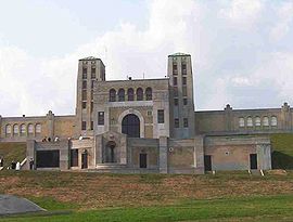 |
|
| Neil McNeil Catholic Secondary School Neil McNeil Catholic Secondary School Neil McNeil Catholic Secondary School is a private, all-boys Roman Catholic secondary school of the Toronto Catholic District School Board in Toronto, Ontario, Canada. Neil McNeil is one of 31 high schools run by the TCDSB and one of four all-boys schools, and currently has an enrollment of 811... |
Kingston Rd | 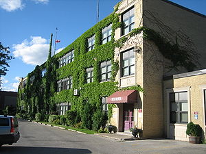 |
|
| Birchmount Quarry | Gerrard St | ||
| Shoppers World Danforth Shoppers World Danforth Shoppers World Danforth is a hybrid shopping plaza and shopping mall in Toronto, Ontario, Canada. It has 40 stores serving parts of East York, Scarborough and The Beaches, near the Victoria Park subway station. Today a moderately sized suburban plaza, it has a notable place in history as one of the... |
Danforth Ave | Former auto plant | |
| Victoria Park subway station Victoria Park (TTC) Victoria Park is a station on the Bloor–Danforth line of the subway system in Toronto, Canada. It is located at 777 Victoria Park Avenue, one block north of Danforth Avenue. The station itself can be accessed by pedestrians via Victoria Park Avenue, or via Albion Avenue, or via a walkway that leads... |
Danforth Ave | 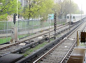 |
|
| Crescent Town | Danforth Ave | 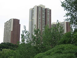 |
|
| Church of St. Jude (Wexford) Church of St. Jude (Wexford) The Church of St. Jude is an historic church in the Scarborough area of Toronto, Canada. St. Jude's was originally built in what was the small rural village of Wexford, Ontario in 1848. The original church building survives today, being used as the cemetery chapel, making it one of the oldest... |
Lawrence Ave | 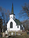 |
|
| Senator O'Connor College School Senator O'Connor College School Senator O'Connor College School is a Roman Catholic high school located in Toronto, Ontario, Canada. It is named after Senator Frank O'Connor, founder of the Laura Secord chocolate company and a generous Catholic philanthropist.- History :... |
Ellesmere Rd | 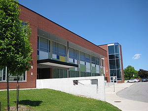 |
|
| Annunciation of the Blessed Virgin Mary Roman Catholic Church | Ellesmere Rd | 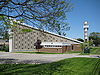 |
|
| Johnny's Charcoal Broiled Hamburgers Johnny's Charcoal Broiled Hamburgers Johnny's Charcoal Broiled Hamburgers, or simply, "Johnny's Hamburgers", is an eatery located in Scarborough, Toronto, at Victoria Park and Sheppard Ave... |
Sheppard Ave | ||
| Victoria Park Presbyterian Church Victoria Park Presbyterian Church The Victoria Park Presbyterian Church is a Presbyterian church in northeast Toronto, Canada. It is currently a member of the Associated Presbyterian Churches, a small, mainly Scottish denomination that emphasizes strict adherence to the Westminster Confession of Faith and the regulative principle... |
Sheppard Ave |
External links
- Victoria Park Avenue at Google MapsGoogle MapsGoogle Maps is a web mapping service application and technology provided by Google, free , that powers many map-based services, including the Google Maps website, Google Ride Finder, Google Transit, and maps embedded on third-party websites via the Google Maps API...