

Vicentinópolis
Encyclopedia
| Vicentópolis | |
|---|---|
| State | Goiás Goiás Goiás is a state of Brazil, located in the central part of the country. The name Goiás comes from the name of an indigenous community... |
| Coordinates: | 17°43′40"S 49°47′21"W |
| Area: | 737.2 km² |
| Population: | 5,919 (IBGE 2005) |
| Elevation: | 646 m |
| Postcode (CEP): | 75555-000 |
| IBGE statistical microregion: | 015 Meia Ponte Microregion Meia Ponte Microregion The Meia Ponte Microregion is a statistical region of Goiás state, Brazil created by the IBGE . It is located south of the state capital, Goiânia, and includes 21 cities with a total population of 338,147 inhabitants . The total area is 21,229.00 km² and the population density is 14.39 inhab/km²... |
| Became a city: | 1980 |
| Mayor: | Neilton Ferreira de Ozêda (January 2005 to January 2009) |
| Distance to Goiânia Goiânia -Climate:The city has a tropical wet and dry climate with an average temperature of . There's a wet season, from October to April, and a dry one, from May to September. Annual rainfall is around 1,520 mm.... : |
176 km. |
| Website: | none |
Town
A town is a human settlement larger than a village but smaller than a city. The size a settlement must be in order to be called a "town" varies considerably in different parts of the world, so that, for example, many American "small towns" seem to British people to be no more than villages, while...
and municipality
Municipality
A municipality is essentially an urban administrative division having corporate status and usually powers of self-government. It can also be used to mean the governing body of a municipality. A municipality is a general-purpose administrative subdivision, as opposed to a special-purpose district...
in south Goiás state
Goiás
Goiás is a state of Brazil, located in the central part of the country. The name Goiás comes from the name of an indigenous community...
, Brazil
Brazil
Brazil , officially the Federative Republic of Brazil , is the largest country in South America. It is the world's fifth largest country, both by geographical area and by population with over 192 million people...
. The population was 5,919 inhabitants in 2005 in a total area of 737.2 km².
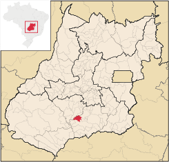
Location
Vicentinópolis is located in the Meia Ponte MicroregionMeia Ponte Microregion
The Meia Ponte Microregion is a statistical region of Goiás state, Brazil created by the IBGE . It is located south of the state capital, Goiânia, and includes 21 cities with a total population of 338,147 inhabitants . The total area is 21,229.00 km² and the population density is 14.39 inhab/km²...
, 22 kilometers west of Joviânia
Joviânia
Joviânia is small town and municipality in south-central Goiás state, Brazil. The population was 6,731 in a total area of 454.9 km² .-Location:...
and 65 kilometers south of Edéia
Edéia
Edéia is a small city and municipality in south-central Goiás state, Brazil.-Municipal Boundaries:Edéia is in the Vale do Rio dos Boisstatistical micro-region and has municipal boundaries with:*north: Indiara*west: Acreúna and Turvelândia...
. The distance to the state capital, Goiânia
Goiânia
-Climate:The city has a tropical wet and dry climate with an average temperature of . There's a wet season, from October to April, and a dry one, from May to September. Annual rainfall is around 1,520 mm....
, is 176 km. Highway connections are made by BR-060 / Abadia de Goiás
Abadia de Goiás
Abadia de Goiás is a small town and municipality in central Goiás state, Brazil, located on the western edge of the Goiânia metropolitan area.-Geographical Data:The distance to Goiânia is 27 km...
/ Guapó
Guapó
Guapó is a small town and municipality in central Goiás state, Brazil. The population was 13,586 and the total area of the municipality was 517.0 km² .Guapó is part of the Goiânia Microregion...
/ Indiara
Indiara
Indiara is a small city and municipality in central-south Goiás state, Brazil. Indiara is a large producer of soybeans and cotton.-Location:Indiara is located in the Vale do Rio dos Bois and has municipal boundaries with:*north: Palmeiras de Goiás...
/ GO-320 / Edéia
Edéia
Edéia is a small city and municipality in south-central Goiás state, Brazil.-Municipal Boundaries:Edéia is in the Vale do Rio dos Boisstatistical micro-region and has municipal boundaries with:*north: Indiara*west: Acreúna and Turvelândia...
. For a list of distances see Sepin
Neighboring municipalities are:
- north: EdéiaEdéiaEdéia is a small city and municipality in south-central Goiás state, Brazil.-Municipal Boundaries:Edéia is in the Vale do Rio dos Boisstatistical micro-region and has municipal boundaries with:*north: Indiara*west: Acreúna and Turvelândia...
- south: PorteirãoPorteirãoPorteirão is a small town and municipality in south Goiás state, Brazil.-Geographical Information:Porteirão is located in the Meia Ponte Microregion in the Rio dos Bois basin. It is connected by a state highway with the BR-452 highway, which connects Rio Verde with Itumbiara.The distance to the...
and GoiatubaGoiatubaGoiatuba is a small city and municipality in south-central Goiás state, Brazil. The population was 31,225 in a total area of 2,475.10 km² . Goiatuba is a large producer of grains, especially soybeans and corn.... - east: JoviâniaJoviâniaJoviânia is small town and municipality in south-central Goiás state, Brazil. The population was 6,731 in a total area of 454.9 km² .-Location:...
and PontalinaPontalinaPontalina is a small city and municipality in south-central Goiás state, Brazil.GeographyPontalina is 125 kilometers from the state capital, Goiânia. It is connected by highways BR-153 and GO-19... - west: EdéiaEdéiaEdéia is a small city and municipality in south-central Goiás state, Brazil.-Municipal Boundaries:Edéia is in the Vale do Rio dos Boisstatistical micro-region and has municipal boundaries with:*north: Indiara*west: Acreúna and Turvelândia...
Vicentinópolis began as a district of Pontalina
Pontalina
Pontalina is a small city and municipality in south-central Goiás state, Brazil.GeographyPontalina is 125 kilometers from the state capital, Goiânia. It is connected by highways BR-153 and GO-19...
in 1964, separating in 1980.
Demographics
- Population density: 8.03 inhab/km² (2007)
- Urban population: 5,189 (2007)
- Rural population: 730 (2007)
- Population growth: -0.23% from 2000/2007
The economy
The economy is based on subsistence agriculture, cattle raising, services, public administration, and small transformation industries.- Industrial units: 4 (2007)
- Commercial units: 97 (2007)
- Financial institutions: - Banco do Brasil S.A. - Banco Itaú S.A. (01/06/2005)
- Cattle herd: 34,545 head (6,660 milk cows) (2006)
- Main crops: rice, beans, manioc, corn, sorghum, wheat, tomatoes, and soybeans (38,500 hectares).
- Farms: 194
- Area of farms: 65,224
- Area of crops: 377 ha.
- Area of pasture: 30,833 ha.
- Farms with tractors: 101
Education (2006)
- Schools: 4 with 1,881 students
- Higher education: campus of the Universidade Estadual de Goiás
- Adult literacy rate: 84.1% (2000) (national average was 86.4%)
Health (2007)
- Hospitals: 2
- Hospital beds: 32
- Ambulatory clinics: 2
- Infant mortality rate: 14.96 (2000) (national average was 33.0).
The municipality achieved a score of 0.773 on the United Nations Human Development Index
Human Development Index
The Human Development Index is a composite statistic used to rank countries by level of "human development" and separate "very high human development", "high human development", "medium human development", and "low human development" countries...
, placing it in 37th place out of 242 municipalities in the state of Goiás
Goiás
Goiás is a state of Brazil, located in the central part of the country. The name Goiás comes from the name of an indigenous community...
. (2000) For the complete list see Frigoletto.com