
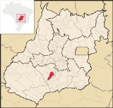
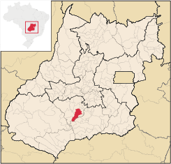
Edéia
Encyclopedia
| Edéia | |
|---|---|
| State | Goiás Goiás Goiás is a state of Brazil, located in the central part of the country. The name Goiás comes from the name of an indigenous community... |
| Area: | 1,466.3 km² |
| Population: | 10,251 (IBGE 2007) |
| Elevation: | 601m above sea level |
| Postcode (CEP): | 75940-000 |
| IBGE statistical microregion: | Vale do Rio dos Bois |
| Became a city: | 1948 |
| Distance to Goiânia Goiânia -Climate:The city has a tropical wet and dry climate with an average temperature of . There's a wet season, from October to April, and a dry one, from May to September. Annual rainfall is around 1,520 mm.... : |
125 km. |
| Website: | Câmara Municipal de Edéia |
| Coordinates: | 17°20′15"S 49°55′43"W |
City
A city is a relatively large and permanent settlement. Although there is no agreement on how a city is distinguished from a town within general English language meanings, many cities have a particular administrative, legal, or historical status based on local law.For example, in the U.S...
and municipality
Municipality
A municipality is essentially an urban administrative division having corporate status and usually powers of self-government. It can also be used to mean the governing body of a municipality. A municipality is a general-purpose administrative subdivision, as opposed to a special-purpose district...
in south-central Goiás
Goiás
Goiás is a state of Brazil, located in the central part of the country. The name Goiás comes from the name of an indigenous community...
state, Brazil
Brazil
Brazil , officially the Federative Republic of Brazil , is the largest country in South America. It is the world's fifth largest country, both by geographical area and by population with over 192 million people...
.
Municipal Boundaries
Edéia is in the Vale do Rio dos Boisstatistical micro-region and has municipal boundaries with:- north: IndiaraIndiaraIndiara is a small city and municipality in central-south Goiás state, Brazil. Indiara is a large producer of soybeans and cotton.-Location:Indiara is located in the Vale do Rio dos Bois and has municipal boundaries with:*north: Palmeiras de Goiás...
- west: AcreúnaAcreúnaAcreúna is a small city and municipality in western Goiás state, Brazil.-Location:Acreúna is located in the statistical micro-region of Vale do Rio dos Bois, southwest of the state capital, Goiânia, on BR-060, which links Goiânia with Rio Verde...
and TurvelândiaTurvelândiaTurvelândia is a small town and municipality in eastern Goiás state, Brazil.-Location:Turvelândia is located 65 km. east of Rio Verde*Highway connections from Goiânia are made by state highway BR-060 west from Goiânia, through / Abadia de Goiás / Guapó / Indiara / Acreúna/ GO-164 / Santa Helena... - east: EdealinaEdealinaEdealina is a small town and municipality in central-south Goiás state, Brazil.-Location:Edealina has municipal boundaries with Edéia, Pontalina, Indiara, and Cezarina The important Rio dos Bois forms part of the municipal boundary....
- south: PontalinaPontalinaPontalina is a small city and municipality in south-central Goiás state, Brazil.GeographyPontalina is 125 kilometers from the state capital, Goiânia. It is connected by highways BR-153 and GO-19...
and VicentinópolisVicentinópolisVicentinópolis is a small town and municipality in south Goiás state, Brazil. The population was 5,919 inhabitants in 2005 in a total area of 737.2 km².-Location:...
Highway connections with the state capital, Goiânia
Goiânia
-Climate:The city has a tropical wet and dry climate with an average temperature of . There's a wet season, from October to April, and a dry one, from May to September. Annual rainfall is around 1,520 mm....
, are made by BR-060 / Guapó
Guapó
Guapó is a small town and municipality in central Goiás state, Brazil. The population was 13,586 and the total area of the municipality was 517.0 km² .Guapó is part of the Goiânia Microregion...
/ Cezarina
Cezarina
Cezarina is a municipality in central Goiás state, Brazil.-Location and Communications:Cezarina belongs to the Vale do Rio dos Bois statistical micro-region. It has municipal boundaries with:*north: Palmeiras de Goiás*south: Edealina*east: Varjão...
/ Indiara
Indiara
Indiara is a small city and municipality in central-south Goiás state, Brazil. Indiara is a large producer of soybeans and cotton.-Location:Indiara is located in the Vale do Rio dos Bois and has municipal boundaries with:*north: Palmeiras de Goiás...
/ GO-320.
Political data
- Eligible voters: 7,839 (12/2007)
- Mayor: Elson Tavares de Freitas (January 2005)
- Vice-mayor: Amilson Ferreira Borges
- Councilmembers: 09
Demographic data
- Population density: 7.01 inhab/km² (2003)
- Population growth rate 2000/2007: 0.05%
- Population in 1980: 12,597
- Population in 1991: 8,999
- Urban population in 2007: 8,511
- Rural population in 2007: 1,740
Economic data
- Industrial units: 10 (06/2007)
- Retail units: 117 (August/2007)
- Banking institutions: Banco do Brasil S.A. - Banco Itaú S.A. (08/2007)
- Automobiles: 1,092 in 2007
- Cooperatives: Coop. Educacional de Edéia Ltda - CEDEL
Agriculture
- Cattle: 79,439 head (2006)
- Cotton 360 ha. /648 tons
- Corn: 2,000 ha. /12,400 tons
- Soybeans: 57,800 ha. / 150,280 tons
- Number of farms: 472
- Agricultural area: 108,948 ha.
- Planted area: 45,400 ha.
- Area of natural pasture: 42,840 ha.
- Workers in agriculture: 1,300
Education and health
- Literacy rate: 86.5% (2000)
- Infant mortality rate: 22.64 in 1,000 live births (2000)
- Schools: 09 with 2,727 students (2006)
- Higher education: Pólo Universitário da UEG
- Hospitals: 02 with 26 beds (2007)
History
Edéia began around 1915, in the settlement called Povoado de Santo Antônio do Alegrete, near the Turvo and Bois rivers, where a chapel to Saint Anthony was erected. Later the name was changed to Alegrete and later in 1938 to Edéia, of unknown origin. The first commercial house appeared in 1913 and the settlement got its municipal emancipation in 1948. Electricity arrived only in 1966.Ranking on the Municipal Human Development Index
Human Development Index
The Human Development Index is a composite statistic used to rank countries by level of "human development" and separate "very high human development", "high human development", "medium human development", and "low human development" countries...
- MHDI: 0.759
- State ranking: 58 (out of 242 municipalities in 2000)
- National ranking: 1,624 (out of 5,507 municipalities in 2000)
For a complete list see Frigoletto