
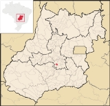
Abadia de Goiás
Encyclopedia
| Abadia de Goiás | |
|---|---|
| State | Goiás Goiás Goiás is a state of Brazil, located in the central part of the country. The name Goiás comes from the name of an indigenous community... |
| Area: | 136.9 km² |
| Population: | 5,868 (IBGE 2007) |
| Elevation: | 898m above sea level |
| Postal code (CEP): | 75345-000 |
| Became a city: | 1997 |
| Statistical Microregion: | Goiânia Microregion Goiânia Microregion The Goiânia Microregion is a region in central Goiás state, Brazil. It includes 17 municipalities with a population of 2,032,305 in a total area of 6,848.00 km².... |
| Distance to Goiânia Goiânia -Climate:The city has a tropical wet and dry climate with an average temperature of . There's a wet season, from October to April, and a dry one, from May to September. Annual rainfall is around 1,520 mm.... : |
27 km. |
| Website: | not available |
Town
A town is a human settlement larger than a village but smaller than a city. The size a settlement must be in order to be called a "town" varies considerably in different parts of the world, so that, for example, many American "small towns" seem to British people to be no more than villages, while...
and municipality
Municipality
A municipality is essentially an urban administrative division having corporate status and usually powers of self-government. It can also be used to mean the governing body of a municipality. A municipality is a general-purpose administrative subdivision, as opposed to a special-purpose district...
in central Goiás
Goiás
Goiás is a state of Brazil, located in the central part of the country. The name Goiás comes from the name of an indigenous community...
state, Brazil
Brazil
Brazil , officially the Federative Republic of Brazil , is the largest country in South America. It is the world's fifth largest country, both by geographical area and by population with over 192 million people...
, located on the western edge of the Goiânia metropolitan area.
Geographical Data
The distance to GoiâniaGoiânia
-Climate:The city has a tropical wet and dry climate with an average temperature of . There's a wet season, from October to April, and a dry one, from May to September. Annual rainfall is around 1,520 mm....
is 27 km. and highway connections are made by BR-060.
Neighboring municipalities are:
- north and east: TrindadeTrindade-Transportation:Trindade are linked with São Tomé and Príncipe's only highways linking to the capital city of São Tomé, another linking Neves and Santana and another linking to Guadalupe as well....
- northwest: GoiâniaGoiânia-Climate:The city has a tropical wet and dry climate with an average temperature of . There's a wet season, from October to April, and a dry one, from May to September. Annual rainfall is around 1,520 mm....
- east: GuapóGuapóGuapó is a small town and municipality in central Goiás state, Brazil. The population was 13,586 and the total area of the municipality was 517.0 km² .Guapó is part of the Goiânia Microregion...
- south: AragoiâniaAragoiâniaAragoiânia is a small town and municipality in central Goiás state, Brazil. The population was 7,243 in a total area of 219.5 km²....
Demographic and Political Data
- Population density: 40.07 inhab/km² (2007)
- Urban population: 3,963 (2007)
- Rural population: 1,905 (2007)
- Eligible voters in 2007: 4683
- City government in 2005: mayor (Antomar Moreira dos Santos), vice-mayor (Maria Lúcia das Graças Matias), and 09 councilpersons
- Households: 1,398 (2000)
- Households earning less than 01 minimum salary: 872 (2000)
Economy
The economy is based on services, government jobs, small industries, cattle raising, poultry, and agriculture.Main Enterprises
- agriculture: 04 units employing 42 workers
- transformation industry: 13 units employing 53 workers
- construction: 07 units employing 21 workers
- commerce: 57 units employing 142 workers
- real estate: 31 units employing 62 workers
- education: 03 units employing 12 workers
- health: 04 units employing 07 workers
- public administration: 03 units employing 168 workers
(IBGE 2003)
The cattle herd consisted of 17,460 head, of which 1,930 were milking cows (2006). The main agricultural products were rice, manioc, and corn.
Health and education
- Infant mortality rate in 2000: 27.70 (28.50 in 1990)
- Literacy rate in 2000: 89.2
There were no hospitals in 2007. There were 06 schools with an enrollment of 1,810.
Source: IBGE
Human Development Index
Human Development Index
The Human Development Index is a composite statistic used to rank countries by level of "human development" and separate "very high human development", "high human development", "medium human development", and "low human development" countries...
: 0.742
- State ranking: 101 (out of 242 municipalities)
- National ranking: 2,112 (out of 5,507 municipalities)