
Viaduct Basin
Encyclopedia
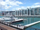
Viaduct Basin is a former commercial harbour on the Auckland waterfront
, now turned into a development of mostly upscale apartments, office space and restaurants. It is located on the site of a formerly run-down area of the Freemans Bay
/ Auckland CBD
waterfront in Auckland City
, New Zealand
. As a centre of activity of the 2000 America's Cup
hosted by the Royal New Zealand Yacht Squadron, the area enjoyed considerable popularity with locals and foreign visitors.
, the Viaduct Basin is so-called because of a failed scheme by the Auckland Harbour Board in the early years of the 20th Century. As the size of ships were increasing dramatically rather than to build new wharves
or dredge the harbour channels, it was proposed that cargo ships moor out in the Waitamata harbour channel and be unloaded into "lighters", small barges that would then ferry the goods to shore via the specially built wharves in the new "Viaduct Lighter Basin". The shipping companies refused to co-operate and forced the Harbour Board to engage in dredging and construct new wharves.
This left the newly completed lighter basin without a real purpose, so it was used to berth the various fishing boats and thus tidy up the appearance of the Auckland waterfront
further east. Next to the Viaduct Basin a fish market and various warehouses were constructed, including Turners & Growers Ltd, the city's main produce wholesalers. Timber mills were also found in the area, and the far side of the area was connected by a mechanical bridge that was able to be raised to allow passage into the basin to the fishing vessels which used it.
In time, the early Europeans settlers in the area moved to other areas, especially after the motorway construction through the Victoria Park
area in the 1950s, and were replaced by labourers arriving from the Pacific Islands as well as Māori newly come to the city. They were living in increasingly derelict housing.
However some of the new residents of the area have objected to the use of the public spaces for events on the grounds of noise, so the attractive and expensive hard landscaping is less used than originally intended, since the area was designed as a setting for ongoing use by large crowds of people as it saw during the America's Cup in 2000. Some local residents have also objected to the high prices charged by the restaurants and shops. Noise and security issues connected with the local venues and eateries are also an ongoing concern as the Viaduct Basin continues to be a popular attraction for Auckland residents and tourists.
The local apartment owners are described as a relatively affluent and somewhat older demographic, with many using their apartments only as their 'city home' while living on places like Waiheke Island
during the weekend. Residents have also complained of the fact that few residents know each other, and that a community spirit is mostly absent in the spanking new quarter, at least in the years after development.
Adjacent to the area are the National Maritime Museum
, the Tepid Baths
pools, Victoria Park
and the stylish Princes Wharf
development. The Auckland CBD and main waterfront areas are directly to the east of the development, while the Northern Motorway a short distance to the west allows connection to parts beyond.
' (a large industrial wharf area further to the west) into residential and/or park areas, has stated that it will be vital to secure the western viaduct area in public ownership (as the eastern edge already is), so that the area can be managed as a single regional facility. This would require securing the America's Cup bases plus the remaining ports areas to allow public access around the entire viaduct.
A 2003 proposal to rename the viaduct into 'Blake Harbour' (for Sir Peter Blake
, a famous New Zealand yachtsman) was not successful.
Auckland waterfront
The Auckland waterfront is a city-side stretch of the southern Waitemata Harbour coastline in Auckland City, New Zealand...
, now turned into a development of mostly upscale apartments, office space and restaurants. It is located on the site of a formerly run-down area of the Freemans Bay
Freemans Bay
Freemans Bay is the name of a former bay and now inner city suburb of Auckland, in the North Island of New Zealand. The historical bay was filled in to a large extent, and lost its shoreline to reclamation works...
/ Auckland CBD
Auckland CBD
The Auckland CBD is the geographical and economic heart of the Auckland metropolitan area. Bounded by several major motorways and by the harbour coastline in the north, it is surrounded further out by mostly suburban areas...
waterfront in Auckland City
Auckland City
Auckland City was the city and local authority covering the Auckland isthmus and most of the islands of the Hauraki Gulf, in the North Island of New Zealand. On 1 November 2010 it was amalgamated into the wider Auckland Region under the authority of the new Auckland Council...
, New Zealand
New Zealand
New Zealand is an island country in the south-western Pacific Ocean comprising two main landmasses and numerous smaller islands. The country is situated some east of Australia across the Tasman Sea, and roughly south of the Pacific island nations of New Caledonia, Fiji, and Tonga...
. As a centre of activity of the 2000 America's Cup
America's Cup
The America’s Cup is a trophy awarded to the winner of the America's Cup match races between two yachts. One yacht, known as the defender, represents the yacht club that currently holds the America's Cup and the second yacht, known as the challenger, represents the yacht club that is challenging...
hosted by the Royal New Zealand Yacht Squadron, the area enjoyed considerable popularity with locals and foreign visitors.
Original purpose
Designed along the line of the basins common in LondonLondon
London is the capital city of :England and the :United Kingdom, the largest metropolitan area in the United Kingdom, and the largest urban zone in the European Union by most measures. Located on the River Thames, London has been a major settlement for two millennia, its history going back to its...
, the Viaduct Basin is so-called because of a failed scheme by the Auckland Harbour Board in the early years of the 20th Century. As the size of ships were increasing dramatically rather than to build new wharves
Wharf
A wharf or quay is a structure on the shore of a harbor where ships may dock to load and unload cargo or passengers.Such a structure includes one or more berths , and may also include piers, warehouses, or other facilities necessary for handling the ships.A wharf commonly comprises a fixed...
or dredge the harbour channels, it was proposed that cargo ships moor out in the Waitamata harbour channel and be unloaded into "lighters", small barges that would then ferry the goods to shore via the specially built wharves in the new "Viaduct Lighter Basin". The shipping companies refused to co-operate and forced the Harbour Board to engage in dredging and construct new wharves.
This left the newly completed lighter basin without a real purpose, so it was used to berth the various fishing boats and thus tidy up the appearance of the Auckland waterfront
Auckland waterfront
The Auckland waterfront is a city-side stretch of the southern Waitemata Harbour coastline in Auckland City, New Zealand...
further east. Next to the Viaduct Basin a fish market and various warehouses were constructed, including Turners & Growers Ltd, the city's main produce wholesalers. Timber mills were also found in the area, and the far side of the area was connected by a mechanical bridge that was able to be raised to allow passage into the basin to the fishing vessels which used it.
In time, the early Europeans settlers in the area moved to other areas, especially after the motorway construction through the Victoria Park
Victoria Park, Auckland
Victoria Park is a park and sports ground in Auckland City, New Zealand. It lies on reclaimed bay land in Freemans Bay, a suburb directly west of the Auckland CBD. This origin of the land makes it very flat and level...
area in the 1950s, and were replaced by labourers arriving from the Pacific Islands as well as Māori newly come to the city. They were living in increasingly derelict housing.
New quarter
The development of the Viaduct Basin in the late 1990s as a mixed-use area of apartments and restaurants has been an uneven success. Some of the resulting buildings are considered very handsome, and the area was provided with a good selection of public, and semi-public spaces. In the basin itself are moored a colourful array of working boats and yachts, some of which are available for charter. The Auckland City Council has initiated a programme of public artworks for the area.However some of the new residents of the area have objected to the use of the public spaces for events on the grounds of noise, so the attractive and expensive hard landscaping is less used than originally intended, since the area was designed as a setting for ongoing use by large crowds of people as it saw during the America's Cup in 2000. Some local residents have also objected to the high prices charged by the restaurants and shops. Noise and security issues connected with the local venues and eateries are also an ongoing concern as the Viaduct Basin continues to be a popular attraction for Auckland residents and tourists.
The local apartment owners are described as a relatively affluent and somewhat older demographic, with many using their apartments only as their 'city home' while living on places like Waiheke Island
Waiheke Island
Waiheke Island is an island in the Hauraki Gulf of New Zealand, located about from Auckland.The island is the second-largest in the Hauraki Gulf after Great Barrier Island. It is the most populated, with nearly 8,000 permanent residents plus another estimated 3,400 who have second or holiday homes...
during the weekend. Residents have also complained of the fact that few residents know each other, and that a community spirit is mostly absent in the spanking new quarter, at least in the years after development.
Adjacent to the area are the National Maritime Museum
National Maritime Museum, New Zealand
The Voyager New Zealand Maritime Museum is New Zealand's premier maritime museum. It is located on Hobson Wharf Auckland, adjacent to Viaduct Harbour...
, the Tepid Baths
Tepid Baths
The Tepid Baths are historical indoor public pools in Auckland, New Zealand. Built in 1914 on the previous site of a small drydock, it quickly met great public approval, with 30,000 visitors in the first two months...
pools, Victoria Park
Victoria Park, Auckland
Victoria Park is a park and sports ground in Auckland City, New Zealand. It lies on reclaimed bay land in Freemans Bay, a suburb directly west of the Auckland CBD. This origin of the land makes it very flat and level...
and the stylish Princes Wharf
Princes Wharf
Princes Wharf is a former commercial wharf on the Auckland waterfront, in Auckland City, New Zealand, which has been redeveloped into a multi-story high-class mixed-use development and cruise ship terminal....
development. The Auckland CBD and main waterfront areas are directly to the east of the development, while the Northern Motorway a short distance to the west allows connection to parts beyond.
Future plans
Auckland City, in its plans to transform the 'Tank FarmWestern Reclamation
The Wynyard Quarter is a reclaimed piece of land on the Waitemata Harbour at the western edge of the Auckland waterfront, New Zealand....
' (a large industrial wharf area further to the west) into residential and/or park areas, has stated that it will be vital to secure the western viaduct area in public ownership (as the eastern edge already is), so that the area can be managed as a single regional facility. This would require securing the America's Cup bases plus the remaining ports areas to allow public access around the entire viaduct.
A 2003 proposal to rename the viaduct into 'Blake Harbour' (for Sir Peter Blake
Peter Blake (yachtsman)
Sir Peter James Blake, KBE was a New Zealand yachtsman who won the Whitbread Round the World Race, the Jules Verne Trophy – setting the fastest time around the world of 74 days 22 hours 17 minutes 22 seconds on catamaran Enza, and led his country to successive victories in the America’s Cup...
, a famous New Zealand yachtsman) was not successful.
External links
- The Viaduct (from theviaduct.co.nz, a local business association, includes photos of pre-redevelopment times)
- The Viaduct (from theviaduct.com, another local business association)
- Tourist reviews and images (from virtualtourist.com)