
Freemans Bay
Encyclopedia
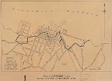
Freemans Bay is the name of a former bay and now inner city suburb of Auckland
, in the North Island
of New Zealand
. The historical bay was filled in to a large extent, and lost its shoreline to reclamation works. Historically a poor and often disreputable quarter, it is now known for its mix of heritage homes and more recent single-dwelling houses, as well as for its two large parks.
 Since the turn of the 20th century, extensive land reclamation (partly using stone quarried from nearby headlands) has seen Freemans Bay itself disappear. The reclamation
of the old bay was finished in 1901, and Victoria Park
was created on most of the resulting flat area. It is still public land used mostly for sports purposes.
The coastline shifted more than one kilometre to the northwest of the city centre and is now composed of the concrete wharves of Viaduct Basin
and the Tank Farm
.

Freemans Bay is probably named after Captain William Hobson
’s secretary, James Stuart Freeman who apparently lived in the area. He was described by John Logan Campbell
in 1844 as "the most disgustingly immoral swindling scoundrel in town".
Local gossip had it that he was not actually married to the woman he was living with, or that there was something amiss in her past. She apparently had been on intimate terms with Mrs Hobson and others in the Government House circle but after William Hobson's death in 1842 and Mrs Hobson's return to Britain she found herself shut out of genteel society in Auckland. This pained Eleanor Freeman enormously and enraged her husband. Living in a workers cottage on the wrong side of town certainly couldn't have helped her social status. After her early death at the age of 26 on 17 December 1844 Freeman added to the wagging tongues by remarrying just six weeks later. After his marriage to Mary Ann Miller on 29 January 1845 the Freemans left New Zealand.
" more and more industrial uses were located such as the abattoir and the gasworks of the Auckland Gas Company
. By 1883 nine shipyard
s, three sawmill
s, a brass and iron foundry
, a glassworks
, an asphalt works as well as several coal and lime traders were present. Also found here were several public facilities like the city morgue
, the night soil
dump and from 1905 the city rubbish incinerator
(known as the 'Destructor', now Victoria Park Market).
Around these occupations were gathered some of the more modest houses in 19th century Auckland. Two land auctions in 1864 in this area were the "Brookville" estate [121 sites] and "Alma Place" [152 sites] The large number of building sites are probably an indication of the small size of the building sections. These workers cottages were built very close together and often poorly constructed. The average house for sale on Franklin Road in 1910 was advertised for ₤736, while the average house in Victoria Road, Remuera, was considered worth ₤1279 at the time. By 1930, the percentage of unskilled workers amongst the male population of Freemans Bay had risen to 39%, whereas in affluent Remuera
it was only 2%. Conversely, only 11% of all males of Freemans Bay worked in "white-collar" or "business and professional" roles, whereas in Remuera the same percentage had grown to 86% by that time, a sign of the increasing homogenification of Auckland suburbs.
In 1905 Victoria Park
was created which included sports grounds, a sports pavilion and a children's playground. The playground equipment was donated by Mr John Court of the John Court Department Store. In 1909 a kindergarten for the local children was opened. It soon ran into financial problems, however, from which it was rescued by John Logan Campbell
. The original brick building which is now unused has been standing in a derelict condition for a number of years whilst awaiting restoration, though NZTA noted in 2010 that it would be restored as part of the works around the Victoria Park Tunnel
. During the 1918 flu epidemic
, the sports pavilion was used as a depot for corpses awaiting transportation by rail to the city cemeteries.
When the motorway system was constructed from 1955 onwards it was an ideal excuse to demolish large areas of Freemans Bay in the name of slum clearance and progress. The motorway cut large swathes through Freemans Bay taking out good housing as well as slum-type buildings. It has been alleged by some critics that the decision to delay completion of the Western Ring Route
(proposed for a long time before the motorway was built through Freemans Bay) was motivated by the fact that the new Auckland Harbour Bridge
required higher toll revenues to repay its construction cost.
Council flats and townhouses were built in the area during the 1960s and 1970s - though a much more extensive 1950s plan, which would have seen most of Freemans Bays' houses levelled and replaced by medium-density housing
blocks, did not come to pass. Only a few blocks were constructed along Whitson Terrace where they are still present today. Later, during the 1980s and 1990s, the remaining Victorian house stock was gentrified
along with the neighbouring suburbs of Ponsonby and St Marys Bay and they are now some of Auckland's most fashionable and desirable residences.
Across the road from Victoria Park now stands Victoria Park Market
, which occupies the buildings of the previous City Council Works Depot. Built between 1905 & 1915 and known as "the Destructor", this facility burnt a great deal of the city's rubbish for many years. It was closed in 1972, and in 1983 the brick industrial complex was converted into the market.
In recent years (2000–2003) the north-eastern part of Freemans Bay's original shoreline has been transformed into the Viaduct Basin
, which served as a headquarters for the various yachting
syndicates involved in the America's Cup
campaigns of 2000 and 2003, and is now an upper-class (multi-story) residential area, which also includes some prestigious office blocks.
The suburb is now home to a much more affluent populace, with the 2006 median income at $41,400, much higher than the $26,800 average Auckland-wide. Around 32% of all residents live in single-person households, some in the many former Council flats still existing in the area, though the housing stock is quite varied.
operates state schools. Freemans Bay School is located in Freemans Bay. Close-by local State secondary schools are Auckland Girls Grammar School and St Mary's College
, though the latter is outside the actual suburb's boundaries.
Auckland
The Auckland metropolitan area , in the North Island of New Zealand, is the largest and most populous urban area in the country with residents, percent of the country's population. Auckland also has the largest Polynesian population of any city in the world...
, in the North Island
North Island
The North Island is one of the two main islands of New Zealand, separated from the much less populous South Island by Cook Strait. The island is in area, making it the world's 14th-largest island...
of New Zealand
New Zealand
New Zealand is an island country in the south-western Pacific Ocean comprising two main landmasses and numerous smaller islands. The country is situated some east of Australia across the Tasman Sea, and roughly south of the Pacific island nations of New Caledonia, Fiji, and Tonga...
. The historical bay was filled in to a large extent, and lost its shoreline to reclamation works. Historically a poor and often disreputable quarter, it is now known for its mix of heritage homes and more recent single-dwelling houses, as well as for its two large parks.
Geography
Land reclamation
Land reclamation, usually known as reclamation, is the process to create new land from sea or riverbeds. The land reclaimed is known as reclamation ground or landfill.- Habitation :...
of the old bay was finished in 1901, and Victoria Park
Victoria Park, Auckland
Victoria Park is a park and sports ground in Auckland City, New Zealand. It lies on reclaimed bay land in Freemans Bay, a suburb directly west of the Auckland CBD. This origin of the land makes it very flat and level...
was created on most of the resulting flat area. It is still public land used mostly for sports purposes.
The coastline shifted more than one kilometre to the northwest of the city centre and is now composed of the concrete wharves of Viaduct Basin
Viaduct Basin
Viaduct Basin is a former commercial harbour on the Auckland waterfront, now turned into a development of mostly upscale apartments, office space and restaurants. It is located on the site of a formerly run-down area of the Freemans Bay / Auckland CBD waterfront in Auckland City, New Zealand...
and the Tank Farm
Western Reclamation
The Wynyard Quarter is a reclaimed piece of land on the Waitemata Harbour at the western edge of the Auckland waterfront, New Zealand....
.
History
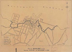
Māori origins
Waiatarau (or 'Reflecting Waters') was the Māori name for the bay that is now Victoria Park, although other names relate to the area; such as Wai Kōtota ('The place where the cockles are harvested') and Te Koranga ('The scaffolds', referring to the racks upon which fish would be hung to dry in the sun). A stream called Waikuta ('Waters of the reed') discharged into the south eastern corner of the bay (bottom of College Hill Road) while the Tunamau ('To catch eels') stream came down from what is now Western Park and met the bay at the bottom of what is now Franklin Road.European name
Freemans Bay is one of the earliest settled areas in Auckland, and was earmarked for development and land reclamation in the 1840s by Colonial Surveyor Felton Matthew who laid out the streets along the shores of the local bays. However, it would be some years yet before the reclamation was to occur.Freemans Bay is probably named after Captain William Hobson
William Hobson
Captain William Hobson RN was the first Governor of New Zealand and co-author of the Treaty of Waitangi.-Early life:...
’s secretary, James Stuart Freeman who apparently lived in the area. He was described by John Logan Campbell
John Logan Campbell
Sir John Logan Campbell was a prominent New Zealand public figure. He was the son of Doctor John Campbell and his wife Catherine. He was described by his contemporaries as "the father of Auckland".- Early life:...
in 1844 as "the most disgustingly immoral swindling scoundrel in town".
Local gossip had it that he was not actually married to the woman he was living with, or that there was something amiss in her past. She apparently had been on intimate terms with Mrs Hobson and others in the Government House circle but after William Hobson's death in 1842 and Mrs Hobson's return to Britain she found herself shut out of genteel society in Auckland. This pained Eleanor Freeman enormously and enraged her husband. Living in a workers cottage on the wrong side of town certainly couldn't have helped her social status. After her early death at the age of 26 on 17 December 1844 Freeman added to the wagging tongues by remarrying just six weeks later. After his marriage to Mary Ann Miller on 29 January 1845 the Freemans left New Zealand.
Industry and slums
While settled as one of the earliest parts of the country by Europeans, the area soon became unfashionable. From the 1850s on, here on the "wrong side of Queen StreetQueen Street, Auckland
Queen Street is the major commercial thoroughfare in the Auckland CBD, Auckland, New Zealand's main population centre. It starts at Queens Wharf on the Auckland waterfront, adjacent to the Britomart Transport Centre and the Downtown Ferry Terminal, and runs uphill for almost three kilometres in a...
" more and more industrial uses were located such as the abattoir and the gasworks of the Auckland Gas Company
Auckland Gas Company
The Auckland Gas Company is a company providing gas for residential or commercial customers in the Auckland area, New Zealand. It is one of the oldest still existing brand names in New Zealand, having been established as Auckland Gas Company Ltd in 1862 or 1863...
. By 1883 nine shipyard
Shipyard
Shipyards and dockyards are places which repair and build ships. These can be yachts, military vessels, cruise liners or other cargo or passenger ships. Dockyards are sometimes more associated with maintenance and basing activities than shipyards, which are sometimes associated more with initial...
s, three sawmill
Sawmill
A sawmill is a facility where logs are cut into boards.-Sawmill process:A sawmill's basic operation is much like those of hundreds of years ago; a log enters on one end and dimensional lumber exits on the other end....
s, a brass and iron foundry
Foundry
A foundry is a factory that produces metal castings. Metals are cast into shapes by melting them into a liquid, pouring the metal in a mold, and removing the mold material or casting after the metal has solidified as it cools. The most common metals processed are aluminum and cast iron...
, a glassworks
Glassblowing
Glassblowing is a glassforming technique that involves inflating molten glass into a bubble, or parison, with the aid of a blowpipe, or blow tube...
, an asphalt works as well as several coal and lime traders were present. Also found here were several public facilities like the city morgue
Morgue
A morgue or mortuary is used for the storage of human corpses awaiting identification, or removal for autopsy or disposal by burial, cremation or otherwise...
, the night soil
Night soil
Night soil is a euphemism for human excrement collected at night from cesspools, privies, etc. and sometimes used as a fertilizer. Night soil is produced as a result of a waste management system in areas without community infrastructure such as a sewage treatment facility, or individual septic...
dump and from 1905 the city rubbish incinerator
Incineration
Incineration is a waste treatment process that involves the combustion of organic substances contained in waste materials. Incineration and other high temperature waste treatment systems are described as "thermal treatment". Incineration of waste materials converts the waste into ash, flue gas, and...
(known as the 'Destructor', now Victoria Park Market).
Around these occupations were gathered some of the more modest houses in 19th century Auckland. Two land auctions in 1864 in this area were the "Brookville" estate [121 sites] and "Alma Place" [152 sites] The large number of building sites are probably an indication of the small size of the building sections. These workers cottages were built very close together and often poorly constructed. The average house for sale on Franklin Road in 1910 was advertised for ₤736, while the average house in Victoria Road, Remuera, was considered worth ₤1279 at the time. By 1930, the percentage of unskilled workers amongst the male population of Freemans Bay had risen to 39%, whereas in affluent Remuera
Remuera
Remuera is a residential suburban area within Auckland city, in the North Island of New Zealand. It is located four kilometres to the southeast of the city centre...
it was only 2%. Conversely, only 11% of all males of Freemans Bay worked in "white-collar" or "business and professional" roles, whereas in Remuera the same percentage had grown to 86% by that time, a sign of the increasing homogenification of Auckland suburbs.
In 1905 Victoria Park
Victoria Park, Auckland
Victoria Park is a park and sports ground in Auckland City, New Zealand. It lies on reclaimed bay land in Freemans Bay, a suburb directly west of the Auckland CBD. This origin of the land makes it very flat and level...
was created which included sports grounds, a sports pavilion and a children's playground. The playground equipment was donated by Mr John Court of the John Court Department Store. In 1909 a kindergarten for the local children was opened. It soon ran into financial problems, however, from which it was rescued by John Logan Campbell
John Logan Campbell
Sir John Logan Campbell was a prominent New Zealand public figure. He was the son of Doctor John Campbell and his wife Catherine. He was described by his contemporaries as "the father of Auckland".- Early life:...
. The original brick building which is now unused has been standing in a derelict condition for a number of years whilst awaiting restoration, though NZTA noted in 2010 that it would be restored as part of the works around the Victoria Park Tunnel
Victoria Park Tunnel
The Victoria Park Tunnel is a motorway tunnel under construction on New Zealand State Highway 1 in Auckland, New Zealand. When finished end of 2011, it is to take the northbound traffic off the Victoria Park Viaduct, which will then be converted to all southbound traffic...
. During the 1918 flu epidemic
Spanish flu
The 1918 flu pandemic was an influenza pandemic, and the first of the two pandemics involving H1N1 influenza virus . It was an unusually severe and deadly pandemic that spread across the world. Historical and epidemiological data are inadequate to identify the geographic origin...
, the sports pavilion was used as a depot for corpses awaiting transportation by rail to the city cemeteries.
Urban renewal
In the 1930s the Auckland City Council set up a committee called "The Decadent Areas Committee" (later renamed as the "Housing Committee") largely to deal with the area. Many Māori who had recently moved to the city for work would come to live in the cheap housing of the area during the next several decades.When the motorway system was constructed from 1955 onwards it was an ideal excuse to demolish large areas of Freemans Bay in the name of slum clearance and progress. The motorway cut large swathes through Freemans Bay taking out good housing as well as slum-type buildings. It has been alleged by some critics that the decision to delay completion of the Western Ring Route
Western Ring Route
The Western Ring Route is a motorway system being constructed in Auckland, New Zealand. It runs along three existing state highways: the Southwestern Motorway , the Northwestern Motorway and the Upper Harbour Highway . When finished it will surpass the Southern Motorway to become the longest...
(proposed for a long time before the motorway was built through Freemans Bay) was motivated by the fact that the new Auckland Harbour Bridge
Auckland Harbour Bridge
The Auckland Harbour Bridge is an eight-lane box truss motorway bridge over the Waitemata Harbour, joining St Marys Bay in Auckland with Northcote in North Shore City, New Zealand. The bridge is part of State Highway 1 and the Auckland Northern Motorway...
required higher toll revenues to repay its construction cost.
Council flats and townhouses were built in the area during the 1960s and 1970s - though a much more extensive 1950s plan, which would have seen most of Freemans Bays' houses levelled and replaced by medium-density housing
Medium-density housing
Medium density housing is a term used in Australia to describe residential developments that are at higher densities than standard low-density, suburban subdivisions, but not so high that they might be regarded as high density housing. The density of standard suburban residential areas has...
blocks, did not come to pass. Only a few blocks were constructed along Whitson Terrace where they are still present today. Later, during the 1980s and 1990s, the remaining Victorian house stock was gentrified
Gentrification
Gentrification and urban gentrification refer to the changes that result when wealthier people acquire or rent property in low income and working class communities. Urban gentrification is associated with movement. Consequent to gentrification, the average income increases and average family size...
along with the neighbouring suburbs of Ponsonby and St Marys Bay and they are now some of Auckland's most fashionable and desirable residences.
Across the road from Victoria Park now stands Victoria Park Market
Victoria Park Market
Victoria Park Market is a craft, souvenir and clothing market and retail complex in Auckland, New Zealand. It is housed in a former waste depot and incinerator complex. The Market is located in Freemans Bay and takes its name from nearby Victoria Park...
, which occupies the buildings of the previous City Council Works Depot. Built between 1905 & 1915 and known as "the Destructor", this facility burnt a great deal of the city's rubbish for many years. It was closed in 1972, and in 1983 the brick industrial complex was converted into the market.
In recent years (2000–2003) the north-eastern part of Freemans Bay's original shoreline has been transformed into the Viaduct Basin
Viaduct Basin
Viaduct Basin is a former commercial harbour on the Auckland waterfront, now turned into a development of mostly upscale apartments, office space and restaurants. It is located on the site of a formerly run-down area of the Freemans Bay / Auckland CBD waterfront in Auckland City, New Zealand...
, which served as a headquarters for the various yachting
Yachting
Yachting refers to recreational sailing or boating, the specific act of sailing or using other water vessels for sporting purposes.-Competitive sailing:...
syndicates involved in the America's Cup
America's Cup
The America’s Cup is a trophy awarded to the winner of the America's Cup match races between two yachts. One yacht, known as the defender, represents the yacht club that currently holds the America's Cup and the second yacht, known as the challenger, represents the yacht club that is challenging...
campaigns of 2000 and 2003, and is now an upper-class (multi-story) residential area, which also includes some prestigious office blocks.
The suburb is now home to a much more affluent populace, with the 2006 median income at $41,400, much higher than the $26,800 average Auckland-wide. Around 32% of all residents live in single-person households, some in the many former Council flats still existing in the area, though the housing stock is quite varied.
Education
The Ministry of EducationMinistry of Education (New Zealand)
The Ministry of Education , is the primary state sector organisation of New Zealand responsible for New Zealand's education system...
operates state schools. Freemans Bay School is located in Freemans Bay. Close-by local State secondary schools are Auckland Girls Grammar School and St Mary's College
Saint Mary's College Auckland
St Mary's College is a year 7 - 13 integrated Catholic girls' high school situated at 11 New Street, Ponsonby, Auckland.-History:St Mary’s College is the oldest existing secondary school for girls in Auckland and one of the oldest existing schools in New Zealand...
, though the latter is outside the actual suburb's boundaries.