

Pannonian Sea
Encyclopedia
Central Europe
Central Europe or alternatively Middle Europe is a region of the European continent lying between the variously defined areas of Eastern and Western Europe...
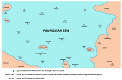
. The Pannonian Sea existed during the Miocene
Miocene
The Miocene is a geological epoch of the Neogene Period and extends from about . The Miocene was named by Sir Charles Lyell. Its name comes from the Greek words and and means "less recent" because it has 18% fewer modern sea invertebrates than the Pliocene. The Miocene follows the Oligocene...
and Pliocene
Pliocene
The Pliocene Epoch is the period in the geologic timescale that extends from 5.332 million to 2.588 million years before present. It is the second and youngest epoch of the Neogene Period in the Cenozoic Era. The Pliocene follows the Miocene Epoch and is followed by the Pleistocene Epoch...
epochs, when three to four kilometres of marine sediments were deposited in the Pannonian Basin
Pannonian Basin
The Pannonian Basin or Carpathian Basin is a large basin in East-Central Europe.The geomorphological term Pannonian Plain is more widely used for roughly the same region though with a somewhat different sense - meaning only the lowlands, the plain that remained when the Pliocene Pannonian Sea dried...
.
History
The Pannonian Sea was part of the Paratethys Sea that got separated during the later part of the MioceneMiocene
The Miocene is a geological epoch of the Neogene Period and extends from about . The Miocene was named by Sir Charles Lyell. Its name comes from the Greek words and and means "less recent" because it has 18% fewer modern sea invertebrates than the Pliocene. The Miocene follows the Oligocene...
Epoch (around 10 million years ago). It was connected with the Mediterranean Sea
Mediterranean Sea
The Mediterranean Sea is a sea connected to the Atlantic Ocean surrounded by the Mediterranean region and almost completely enclosed by land: on the north by Anatolia and Europe, on the south by North Africa, and on the east by the Levant...
through the territory of the modern Rona Gulf, Bavaria
Bavaria
Bavaria, formally the Free State of Bavaria is a state of Germany, located in the southeast of Germany. With an area of , it is the largest state by area, forming almost 20% of the total land area of Germany...
and Vienna Basin
Vienna Basin
The Vienna Basin is a sedimentary basin between the Alps and the Carpathian Mountains...
).
Through the Đerdap Strait, the Pannonian Sea was connected to a sea in the Wallachia
Wallachia
Wallachia or Walachia is a historical and geographical region of Romania. It is situated north of the Danube and south of the Southern Carpathians...
n-Pontic
Black Sea
The Black Sea is bounded by Europe, Anatolia and the Caucasus and is ultimately connected to the Atlantic Ocean via the Mediterranean and the Aegean seas and various straits. The Bosphorus strait connects it to the Sea of Marmara, and the strait of the Dardanelles connects that sea to the Aegean...
Basin. During its largest geographical extent, the Pannonian Sea reached the south of modern Serbia
Serbia
Serbia , officially the Republic of Serbia , is a landlocked country located at the crossroads of Central and Southeast Europe, covering the southern part of the Carpathian basin and the central part of the Balkans...
: a gulf of the Pannonian Sea in the modern Morava
Morava
Morava is a Slavic river name. It may refer to:Rivers:* Great Morava in central Serbia** South Morava , tributary of the Great Morava** West Morava , tributary of the Great Morava...
river valley stretched to modern Grdelica Gulch and Vranje Depression and was connected to the Aegean Sea
Aegean Sea
The Aegean Sea[p] is an elongated embayment of the Mediterranean Sea located between the southern Balkan and Anatolian peninsulas, i.e., between the mainlands of Greece and Turkey. In the north, it is connected to the Marmara Sea and Black Sea by the Dardanelles and Bosporus...
through the modern Preševo Valley
Preševo Valley
The Preševo Valley , is an Albanian political catchphrase used to describe the two south Serbian municipalities of Bujanovac and Preševo, which have a majority ethnic Albanian population. Medvedja municipality is sometimes also included under this term, although it has a majority Serbian population...
.
The Pannonian Sea existed for about 9 million years. Its last remains disappeared in the middle of Pleistocene
Pleistocene
The Pleistocene is the epoch from 2,588,000 to 11,700 years BP that spans the world's recent period of repeated glaciations. The name pleistocene is derived from the Greek and ....
Epoch, about 600,000 years ago. The water of the Pannonian Sea broke through the modern Đerdap Gorge
Iron Gate (Danube)
The Iron Gates The gorge lies between Romania in the north and Serbia in the south. At this point, the river separates the southern Carpathian Mountains from the northwestern foothills of the Balkan Mountains. The Romanian, Hungarian, Slovakian, Turkish, German and Bulgarian names literally mean...
(Iron Gate) on the Danube
Danube
The Danube is a river in the Central Europe and the Europe's second longest river after the Volga. It is classified as an international waterway....
river and flowed through the gorge leaving behind a large plain known as the Pannonian Plain. The remnants of the former islands of the Pannonian Sea are the modern Pannonian Island Mountains
Pannonian Island Mountains
The Pannonian island mountains is a name for mountains located in the southern Pannonian Plain, in the Serbian province of Vojvodina. They include Fruška Gora and Vršac Mountains...
(Fruška Gora
Fruška Gora
Fruška Gora is a mountain in north Syrmia. Most part of the territory is located within Vojvodina, Serbia, but a smaller part on its western side overlaps the territory of Croatia...
and Vršac Mountains
Vršac Mountains
The Vršac Mountains , also known as Vršac Hill , are mountains located near Vršac , in the Serbian province of Vojvodina and partially also in Romania. They represent an independent and distinct massif, 19 kilometers long and spreading on an area of 170 square kilometers, of which 122 belong to...
).
See also
- ParatethysParatethysThe Paratethys ocean, Paratethys sea or just Paratethys was a large shallow sea that stretched from the region north of the Alps over Central Europe to the Aral Sea in western Asia. The sea was formed during the Oxfordian epoch as an extension of the rift that formed the Central Atlantic Ocean and...
- Pannonian Plain
- Pannonian BasinPannonian BasinThe Pannonian Basin or Carpathian Basin is a large basin in East-Central Europe.The geomorphological term Pannonian Plain is more widely used for roughly the same region though with a somewhat different sense - meaning only the lowlands, the plain that remained when the Pliocene Pannonian Sea dried...
- Piemont-Liguria OceanPiemont-Liguria OceanThe Piemont-Liguria basin or the Piemont-Liguria Ocean was a former piece of oceanic crust that is seen as part of the Tethys Ocean...
- Iron Gate (Danube)Iron Gate (Danube)The Iron Gates The gorge lies between Romania in the north and Serbia in the south. At this point, the river separates the southern Carpathian Mountains from the northwestern foothills of the Balkan Mountains. The Romanian, Hungarian, Slovakian, Turkish, German and Bulgarian names literally mean...
External links
- Map of the Pannonian Sea (in Hungarian)
- Map of the Pannonian Sea (in German)