
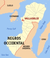
Valladolid, Negros Occidental
Encyclopedia
Valladolid is a 4th class municipality in the province of Negros Occidental, Philippines
Philippines
The Philippines , officially known as the Republic of the Philippines , is a country in Southeast Asia in the western Pacific Ocean. To its north across the Luzon Strait lies Taiwan. West across the South China Sea sits Vietnam...
. At the 2000 census, it had a population of 32,576 people in 6,653 households. The mayor of the municipality is Romel P. Yogore who won against Ricardo Presbitero in the last May 2007 elections.
Known as the "Food Basket of Negros Occidental," the municipality celebrates its fiesta every 28 February.
History
The place was first called “Inabuyan” until the SpanishSpain
Spain , officially the Kingdom of Spain languages]] under the European Charter for Regional or Minority Languages. In each of these, Spain's official name is as follows:;;;;;;), is a country and member state of the European Union located in southwestern Europe on the Iberian Peninsula...
leaders arrived and one of them named the place after his native town Valladolid in Spain
Spain
Spain , officially the Kingdom of Spain languages]] under the European Charter for Regional or Minority Languages. In each of these, Spain's official name is as follows:;;;;;;), is a country and member state of the European Union located in southwestern Europe on the Iberian Peninsula...
. During the [Spanish]] era, Valladolid was considered one of the most prosperous towns of Negros Occidental
Negros Occidental
Negros Occidental is a province of the Philippines located in the Western Visayas region. Its capital is Bacolod City and it occupies the northwestern half of Negros Island; Negros Oriental is at the southeastern half...
. The size of the convent and church built by the Recollect
Recollect
The term Recollect refers to a group that resulted from the various reformation that happened into the different mendicant orders during the middle ages...
Missionaries in 1851 were proofs of this status considering that the church authorities were powerful in running the affairs of the government.
Valladolid was established in 1860. The influx of settlers from the neighboring islands of Guimaras
Guimaras
Guimaras is an island province of the Philippines located in the Western Visayas region. Among the smallest provinces, its capital is Jordan. The island is located in the Panay Gulf, between the islands of Panay and Negros...
, Panay
Panay
Panay may refer to*Panay Island*Panay *Panay, Capiz*Panay River*Panay Gulf* USS Panay *Panay incident...
and Cebu
Cebu
Cebu is a province in the Philippines, consisting of Cebu Island and 167 surrounding islands. It is located to the east of Negros, to the west of Leyte and Bohol islands...
prompted the then Governor Saravia to create an additional town which is now Pulupandan. The settlers made this town a landing area in coming to Negros, brought about by the introduction of sugar which resulted in the economic growth and prosperity of the island. The town is known as the Rice Granary of Negros Occidental
Negros Occidental
Negros Occidental is a province of the Philippines located in the Western Visayas region. Its capital is Bacolod City and it occupies the northwestern half of Negros Island; Negros Oriental is at the southeastern half...
with 90 percent of its arable land planted to palay. It produce more than half a million cavans of rice every year. It also produces vegetables, fruits and the diwal or angel wings shell, a seasonal delicacy.
The Aetas were the original inhabitants of Valladolid. They were ultimately forced to move to the uplands when the early settlers and colonizers came to stay. Significant events in the province during the early founding years as well as major upheavals during and after the revolutionary period brought profound changes in the municipality.
By and large, Valladolid has its place in the historical set-up of the province of Negros Occidental
Negros Occidental
Negros Occidental is a province of the Philippines located in the Western Visayas region. Its capital is Bacolod City and it occupies the northwestern half of Negros Island; Negros Oriental is at the southeastern half...
socially, spiritually, economically and politically. It is also the bulwark of Filipinistas Aglipayan in Negros. This dominant sect caused the defeat of the fiery Manuel L. Quezon
Manuel L. Quezon
Manuel Luis Quezón y Molina served as president of the Commonwealth of the Philippines from 1935 to 1944. He was the first Filipino to head a government of the Philippines...
in the hands of the Aglipayans in the presidential election of 1935 during the Commonwealth
Commonwealth
Commonwealth is a traditional English term for a political community founded for the common good. Historically, it has sometimes been synonymous with "republic."More recently it has been used for fraternal associations of some sovereign nations...
era.
Pasundayag Festival is a thanksgiving and celebration of good harvest. It is a farmers festival in honor of the town’s patroness, Nuestra Señora de Guadalupe featuring street dancing competition, arena festival dance showdown and merry making.
In 1957, Sitio Paloma was converted into a barrio.
Religion
- Philippine Independent Church- Majority of the population of the town are followers of the Aglipayan faith.
- Roman Catholic Church
Geography
Valladolid Municipality is located on the southwestern coast of the Province of Negros OccidentalNegros Occidental
Negros Occidental is a province of the Philippines located in the Western Visayas region. Its capital is Bacolod City and it occupies the northwestern half of Negros Island; Negros Oriental is at the southeastern half...
. It is approximately a 35-minute drive from Bacolod City
Bacolod City
The City of Bacolod , is a highly urbanized midsize Philippine city. It is the capital of the Negros Occidental province. Having a total of 499,497 inhabitants as of August 1, 2007, it is the most populous city in the Western Visayas Region. It is currently ranked as the 17th most populous city in...
by private car and 45 minutes by public utility vehicles via the main highway.
Valladolid is bounded on the north by the town of Pulupandan, on the south by the municipality of San Enrique
San Enrique, Negros Occidental
San Enrique is a 4th class municipality in the province of Negros Occidental, Philippines. According to the 2000 census, it has a population of 22,091 people in 4,419 households.-Barangays:San Enrique is politically subdivided into 10 barangays.* Bagonawa...
, on the west by the Guimaras
Guimaras
Guimaras is an island province of the Philippines located in the Western Visayas region. Among the smallest provinces, its capital is Jordan. The island is located in the Panay Gulf, between the islands of Panay and Negros...
Strait and on the east by the city of La Carlota
La Carlota City
La Carlota City is a 3rd class city in the province of Negros Occidental, Philippines. According to the 2007 census, it has a population of 65,669 people in 13,497 households. The city was known as Simancas until 1871, two years after its foundation...
. The global location of Municipality of Valladolid is 10 degrees, 27 minutes 54 seconds - north and 122 degrees 49 minutes 33.6 seconds - east with Our Lady of Guadalupe Church as the benchmark.
Valladolid has two pronounced seasons, wet and dry. The rainy season starts from May to January of the following year with heavy rains occurring during the months of August and September. Dry season starts from the month of February until the last week of April.
Barangays
Valladolid is geographically subdivided into 16 barangayBarangay
A barangay is the smallest administrative division in the Philippines and is the native Filipino term for a village, district or ward...
s.
|
|
Primary Level
Public
|
Private
|
Secondary Level
- Francisco Infante Memorial High School
- Tabao National high School
- Tabao National High School Lacaron Extension
- Valladolid National High School
Resources and Economy
Major Industries
|
Major Products
|
Water
Clean and safe water supply provided by Valladolid Water District.
Power
Abundant power supply provided by NOCECO
General Landmarks
- Our Lady of Guadalupe Church
Our Lady of Guadalupe Church was founded in 1851 by the Recollect Missionaries and reputed to be the biggest in the province. The size of the church and convent is a living proof that Valladolid stood among the island’s most progressive pueblos during the Spanish era.
- Balay Dolid (Valladolid Community Museum)
Balay Dolid (Valladolid Community Museum) is one of the ancestral houses in town owned by the Ykalina family. The Valladolid Community Museum features the rich cultural heritage of the town.
- Sunset Boulevard
It is a perfect place to watch the beautiful sunset along the Guimaras
Guimaras
Guimaras is an island province of the Philippines located in the Western Visayas region. Among the smallest provinces, its capital is Jordan. The island is located in the Panay Gulf, between the islands of Panay and Negros...
Strait. A good venue to commune with nature as the water laps along the seawall.
- Century-old Acacia Haven
32 Acacia trees surround the public plaza and provide shade to all passers. It was planted by the first town official by the name of Ykalina.
- Relic of an 18th Century Graveyard
This resting place was solely intended for the Ilustrados or the rich member of the community during that time. The area is about 3 hectares surrounded by coral reef stones giving the place a classic effect.
- Fruit Stand by the Highway
Situated at the highway of Brgy. Palaka, travelers pass by this area displaying mouth-watering mangoes, watermelon, fruit jams and other exotic delicacies.
- Highway Food Park
Located along the highway between Brgy. Palaka and Crossing Pacol, this food park is composed of stalls serving breakfast, lunch and dinner. Menu varies from meat, vegetables to fresh seafood.
- Tabao Fish Terminal Food Court
Tabao Fish Terminal Food Court at Brgy. Central Tabao Fish Terminal opens at 11:00 p.m. to 5:00 a.m. Offers grilled fish, tinola and kinilaw. Also serves coffee with native “Ibus or Suman”.
- Tabao Weavers Association (TWA) Display Center
At Brgy. Central Tabao offers hand woven products ideal for souvenir.