
Utah State Route 269
Encyclopedia
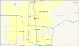
State Route 269 is a state highway
in the U.S.
state of Utah
that sits completely within Salt Lake City
in Salt Lake County
. It consists entirely of a one-way pair
of 500 South and 600 South, two parallel one-way streets that connect I-15 and I-80 to downtown Salt Lake City
. SR-269 was designated in 1960 and constructed later that decade, coinciding with the construction of I-15 in the area.
Prior to 2000, SR-269 began and ended with viaduct
s that were longer than they are now. From the western terminus, the viaduct extended from I-15/I-80 to 200 West, two blocks east of where the viaduct ends presently. The other segment's viaduct began at 300 West (also two blocks east of where it begins now) and extended to I-15/I-80. As a part of I-15's reconstruction and then-Salt Lake City Mayor Deedee Corradini
's Gateway
project, the viaducts were drastically shortened.
The route connects the city center with the freeway. As the settlers of Utah laid their towns with amply wide streets, one-way streets are rare in the city, SR-269 being one of two such pair
s in existence. As part of I-15's construction in the 1960s, planners felt that two one-way streets with many lanes leading to and from the freeway would be better utilized. The Salt Lake City and County Building
is located at the route's junction with US-89.
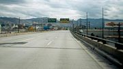
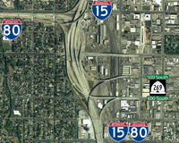
The highway begins its eastbound stint from two exits from eastbound I-80 and northbound I-15. The two ramps join together to form five eastbound lanes on a viaduct west of 600 West along 600 South. It reaches grade-level at 400 West and enters downtown
. Past 200 West, the road loses one lane. The highway continues east three blocks before state maintenance ends at US-89 (State Street). The westbound section begins at US-89 and heads west on four lanes along 500 South. After intersecting with SR-270 (West Temple), one lane is gained; a block further east at 200 West, the road widens with one additional lane. After 500 West, the highway elevates to above grade-level with four lanes and dips southwest before two lanes default onto southbound I-15/eastbound I-80 and the two other lanes default onto westbound I-80.
 As I-15 was being constructed through the Wasatch Front
, the State Road Commission designated three routes—SR-268
, SR-269, and SR-270
—in 1960 as direct connections into Salt Lake City's downtown
. All three had viaducts connecting the freeway to a road closer to the city center. At the time of the freeway's construction, the federal funding share formula allowed the use of funds to construct exits from the freeway to where they reached grade level. This permitted Utah to construct exit ramps with considerable length. The initial extent of SR-269 was only the elevated viaducts, stretching from I-15 east to 300 West (SR-176), which then carried US-40, US-89, and US-91 through downtown. Since the final design included a bridge over SR-176 on 600 South, the eastbound direction was extended one block to 200 West in 1963. The state legislature extended both directions further to SR-271 (State Street, now US-89) in 1969.
As Salt Lake City won the bid for the 2002 Winter Olympics
in 1995, I-15 was reconstructed. As part of the reconstruction, SR-268 and SR-269's viaducts into the city were set to be reconstructed and shortened. Mayor Corradini wanted to revitalize an industrial portion of Salt Lake City with her Gateway project. A part of her project included demolishing the almost mile-long viaducts of SR-269, as she felt a freeway bridge passing over the area she was trying to revitalize would be a hindrance to the project. The pair of viaducts were demolished in late-1998–early-1999, replaced with much shorter viaducts in 2000.
, Salt Lake County
.
State highway
State highway, state road or state route can refer to one of three related concepts, two of them related to a state or provincial government in a country that is divided into states or provinces :#A...
in the U.S.
United States
The United States of America is a federal constitutional republic comprising fifty states and a federal district...
state of Utah
Utah
Utah is a state in the Western United States. It was the 45th state to join the Union, on January 4, 1896. Approximately 80% of Utah's 2,763,885 people live along the Wasatch Front, centering on Salt Lake City. This leaves vast expanses of the state nearly uninhabited, making the population the...
that sits completely within Salt Lake City
Salt Lake City, Utah
Salt Lake City is the capital and the most populous city of the U.S. state of Utah. The name of the city is often shortened to Salt Lake or SLC. With a population of 186,440 as of the 2010 Census, the city lies in the Salt Lake City metropolitan area, which has a total population of 1,124,197...
in Salt Lake County
Salt Lake County, Utah
Salt Lake County is a county located in the U.S. state of Utah. It had a population of 1,029,655 at the 2010 census. Its county seat and largest city is Salt Lake City, the state capital. It occupies Salt Lake Valley, as well as parts of the surrounding mountains, the Oquirrh Mountains to the west...
. It consists entirely of a one-way pair
One-way pair
A one-way pair, one-way couple, or just couplet is a pair of parallel, usually one-way streets that carry opposite directions of a signed route or major traffic flow, or sometimes opposite directions of a bus or streetcar route....
of 500 South and 600 South, two parallel one-way streets that connect I-15 and I-80 to downtown Salt Lake City
Downtown Salt Lake City
Downtown is the oldest district in Salt Lake City. The grid from which the entire city is laid out originates at Temple Square, the location of the Salt Lake Temple.-Location:...
. SR-269 was designated in 1960 and constructed later that decade, coinciding with the construction of I-15 in the area.
Prior to 2000, SR-269 began and ended with viaduct
Viaduct
A viaduct is a bridge composed of several small spans. The term viaduct is derived from the Latin via for road and ducere to lead something. However, the Ancient Romans did not use that term per se; it is a modern derivation from an analogy with aqueduct. Like the Roman aqueducts, many early...
s that were longer than they are now. From the western terminus, the viaduct extended from I-15/I-80 to 200 West, two blocks east of where the viaduct ends presently. The other segment's viaduct began at 300 West (also two blocks east of where it begins now) and extended to I-15/I-80. As a part of I-15's reconstruction and then-Salt Lake City Mayor Deedee Corradini
Deedee Corradini
Deedee Corradini served as mayor of Salt Lake City, Utah from 1992 to 2000. Corradini was Salt Lake City's first and to date only female mayor....
's Gateway
Gateway District
The Gateway District is a large open air retail, residential and office complex in Salt Lake City, Utah, United States. The complex is centered around the historic Union Pacific Depot in downtown Salt Lake City...
project, the viaducts were drastically shortened.
The route connects the city center with the freeway. As the settlers of Utah laid their towns with amply wide streets, one-way streets are rare in the city, SR-269 being one of two such pair
One-way pair
A one-way pair, one-way couple, or just couplet is a pair of parallel, usually one-way streets that carry opposite directions of a signed route or major traffic flow, or sometimes opposite directions of a bus or streetcar route....
s in existence. As part of I-15's construction in the 1960s, planners felt that two one-way streets with many lanes leading to and from the freeway would be better utilized. The Salt Lake City and County Building
Salt Lake City and County Building
The Salt Lake City and County Building, usually called the "City-County Building", is the seat of government for Salt Lake City, Utah. The historic landmark formerly housed offices for Salt Lake County government as well, hence the name.- History :...
is located at the route's junction with US-89.
Route description
SR-269 has two separate segments that lay a block apart, both one-way streets; the eastbound segment is known as 600 South (ceremoniously Martin Luther King Jr. Boulevard), while the westbound segment is named 500 South (officially Cesar E. Chavez Boulevard).The highway begins its eastbound stint from two exits from eastbound I-80 and northbound I-15. The two ramps join together to form five eastbound lanes on a viaduct west of 600 West along 600 South. It reaches grade-level at 400 West and enters downtown
Downtown Salt Lake City
Downtown is the oldest district in Salt Lake City. The grid from which the entire city is laid out originates at Temple Square, the location of the Salt Lake Temple.-Location:...
. Past 200 West, the road loses one lane. The highway continues east three blocks before state maintenance ends at US-89 (State Street). The westbound section begins at US-89 and heads west on four lanes along 500 South. After intersecting with SR-270 (West Temple), one lane is gained; a block further east at 200 West, the road widens with one additional lane. After 500 West, the highway elevates to above grade-level with four lanes and dips southwest before two lanes default onto southbound I-15/eastbound I-80 and the two other lanes default onto westbound I-80.
History
Wasatch Front
The Wasatch Front is a metropolitan region in the north-central part of the U.S. state of Utah. It consists of a chain of cities and towns stretched along the Wasatch Range from approximately Santaquin in the south to Brigham City in the north...
, the State Road Commission designated three routes—SR-268
Utah State Route 268
State Route 268 is a state highway in the U.S. state of Utah that connects I-15 to US-89 in a span of . The highway is completely within Salt Lake City and is routed along 600 North.-Route description:...
, SR-269, and SR-270
Utah State Route 270
State Route 270 is a short north–south thoroughfare that sits completely within Salt Lake City in Salt Lake County, entirely along West Temple Street...
—in 1960 as direct connections into Salt Lake City's downtown
Downtown Salt Lake City
Downtown is the oldest district in Salt Lake City. The grid from which the entire city is laid out originates at Temple Square, the location of the Salt Lake Temple.-Location:...
.
As Salt Lake City won the bid for the 2002 Winter Olympics
2002 Winter Olympics
The 2002 Winter Olympics, officially the XIX Olympic Winter Games, were a winter multi-sport event that was celebrated in February 2002 in and around Salt Lake City, Utah, United States. Approximately 2,400 athletes from 77 nations participated in 78 events in fifteen disciplines, held throughout...
in 1995, I-15 was reconstructed. As part of the reconstruction, SR-268 and SR-269's viaducts into the city were set to be reconstructed and shortened. Mayor Corradini wanted to revitalize an industrial portion of Salt Lake City with her Gateway project. A part of her project included demolishing the almost mile-long viaducts of SR-269, as she felt a freeway bridge passing over the area she was trying to revitalize would be a hindrance to the project. The pair of viaducts were demolished in late-1998–early-1999, replaced with much shorter viaducts in 2000.
Major intersections
The entire route is located in Salt Lake CitySalt Lake City, Utah
Salt Lake City is the capital and the most populous city of the U.S. state of Utah. The name of the city is often shortened to Salt Lake or SLC. With a population of 186,440 as of the 2010 Census, the city lies in the Salt Lake City metropolitan area, which has a total population of 1,124,197...
, Salt Lake County
Salt Lake County, Utah
Salt Lake County is a county located in the U.S. state of Utah. It had a population of 1,029,655 at the 2010 census. Its county seat and largest city is Salt Lake City, the state capital. It occupies Salt Lake Valley, as well as parts of the surrounding mountains, the Oquirrh Mountains to the west...
.
- Note: mileposts are measured from west to east on the eastbound side and east to west on the westbound side. Both figures are given in the table.
Mile Destinations Notes 0.000
1.807– Las Vegas, Cheyenne, Reno, Salt Lake International Airport Westbound exit and eastbound entrance 0.311
1.494Former SR-176 0.612
1.1920.904
0.905