

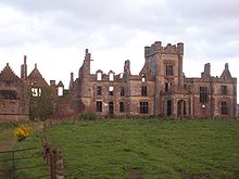
Ury House
Encyclopedia
may2006.jpg)
Ruins
Ruins are the remains of human-made architecture: structures that were once complete, as time went by, have fallen into a state of partial or complete disrepair, due to lack of maintenance or deliberate acts of destruction...
large mansion
Mansion
A mansion is a very large dwelling house. U.S. real estate brokers define a mansion as a dwelling of over . A traditional European mansion was defined as a house which contained a ballroom and tens of bedrooms...
built in the Elizabethan style in 1885 by Alexander Baird. It is situated about a mile north of Stonehaven
Stonehaven
Stonehaven is a town in Aberdeenshire, Scotland. It lies on Scotland's northeast coast and had a population of 9,577 in 2001 census.Stonehaven, county town of Kincardineshire, grew around an Iron Age fishing village, now the "Auld Toon" , and expanded inland from the seaside...
, a town in Aberdeenshire
Aberdeenshire
Aberdeenshire is one of the 32 unitary council areas in Scotland and a lieutenancy area.The present day Aberdeenshire council area does not include the City of Aberdeen, now a separate council area, from which its name derives. Together, the modern council area and the city formed historic...
(historic Kincardineshire
Kincardineshire
The County of Kincardine, also known as Kincardineshire or The Mearns was a local government county on the coast of northeast Scotland...
) on the North-East coast of Scotland
Scotland
Scotland is a country that is part of the United Kingdom. Occupying the northern third of the island of Great Britain, it shares a border with England to the south and is bounded by the North Sea to the east, the Atlantic Ocean to the north and west, and the North Channel and Irish Sea to the...
. Originally the estate belonged to the Fraser
Fraser
-Australia:* Fraser, Australian Capital Territory, a suburb in the Canberra district of Belconnen* The Division of Fraser, an electoral division in the northern Australian Capital Territory* Fraser Island, along the coast of Queensland-Canada:* Fraser River...
s, then the Hays starting in 1413, but eventually property of the Earl Marischal; over the years Ury has been rebuilt three times. In early times the property was known as Urie. In the 17th century Ury was established as the North East Scotland headquarters of the Quaker organisation by David Barclay
David Barclay (Quaker)
Col. David Barclay , of Mathers, St Cyrus, Kincardineshire in Scotland, was 1st Laird of Urie near Stonehaven, Kincardineshire, Scotland, and father of Robert Barclay, the eminent Quaker apologist...
.
Today the house is derelict and the dangerous condition of the structure limits entry. In March 2007 the current owners of the estate, FM Developments lodged an amended planning application for a golf and leisure complex on the estate as the previous housing development was rejected in October 2006. There have been earlier proposals for its restoration, including a 2004 planning application, which was rejected by the local Community Council.
Ancient history
Bronze Age cists have been found at the site of the Ury House. Roman legionRoman legion
A Roman legion normally indicates the basic ancient Roman army unit recruited specifically from Roman citizens. The organization of legions varied greatly over time but they were typically composed of perhaps 5,000 soldiers, divided into maniples and later into "cohorts"...
s marched from Raedykes
Raedykes
Raedykes is the site of a Roman marching camp located just over 3 miles NW of Stonehaven, Aberdeenshire, Scotland. National Grid Reference NO 842902...
to Normandykes
Normandykes
Normandykes is the site of a Roman marching camp to the southwest of Peterculter, Aberdeenshire, Scotland. The near-rectangular site, measuring approximately , covers about of the summit and eastern slopes of a hill overlooking the River Dee and the B9077 road further south. Aerial photographs...
Roman Camp nearby as they used higher ground evading the bog
Bog
A bog, quagmire or mire is a wetland that accumulates acidic peat, a deposit of dead plant material—often mosses or, in Arctic climates, lichens....
s of Red Moss and low-lying mosses associated with the Burn of Muchalls
Burn of Muchalls
The Burn of Muchalls is an easterly flowing stream in Aberdeenshire, Scotland that discharges to the North Sea. Its point of discharge is on a rocky beach set with scenic sea stacks...
. That march used the Elsick Mounth
Elsick Mounth
The Elsick Mounth is an ancient trackway crossing the Grampian Mountains in the vicinity of Netherley, Scotland. This trackway was one of the few means of traversing the Grampian Mounth area in prehistoric and medieval times. The highest pass of the route is attained within the Durris Forest...
, one of the ancient trackway
Trackway
A trackway is an ancient route of travel for people or animals. In biology, a trackway can be a set of impressions in the soft earth, usually a set of footprints, left by an animal. A fossil trackway is the fossilized imprint of a trackway. Trackways have been found all over the world...
s crossing the Mounth
Mounth
The Mounth is the range of hills on the southern edge of Strathdee in northeast Scotland. It was usually referred to with the article, i.e. "the Mounth". The name is a corruption of the Scottish Gaelic monadh which in turn is akin to the Welsh mynydd, and may be of Pictish origin...
of the Grampian Mountains, lying west of Netherley.
Related proximity historic features
There are several notable historic structures and sites close to the Ury House, including:- Fetteresso CastleFetteresso CastleFetteresso Castle is a 14th century towerhouse, rebuilt in 1761 as a Scottish gothic style Palladian manor, with clear evidence of prehistoric use of the site. It is situated immediately west of the town of Stonehaven in Kincardineshire slightly to the west of the A90 dual carriageway...
- Muchalls CastleMuchalls CastleMuchalls Castle stands overlooking the North Sea in the countryside of Kincardine and Mearns, Aberdeenshire, Scotland. The lower course is a well preserved double groined 13th century towerhouse structure, built by the Frasers of Muchalls. Upon this structure, the 17th century castle was begun by...
- RaedykesRaedykesRaedykes is the site of a Roman marching camp located just over 3 miles NW of Stonehaven, Aberdeenshire, Scotland. National Grid Reference NO 842902...
Roman Camp - Rickarton HouseRickarton HouseRickarton House is an historic home in Aberdeenshire, Scotland approximately six kilometres northwest of Stonehaven. Other notable historic structures in the vicinity are Ury House, Fetteresso Castle and Muchalls Castle...
Natural features
Ury Estate is bounded on the west by Fetteresso ForestFetteresso Forest
The Fetteresso Forest is a woodland that is principally coniferous situated in the Mounth range of the Grampian Mountains in Aberdeenshire, Scotland. The forest has a number of prominent mountain peaks including the Hill of Blacklodge and Craiginour peak...
. Within about 150 metres south of Ury House is the confluence of the Burn of Monboys
Burn of Monboys
Burn of Monboys is a stream that rises in the Mounth, or eastern range of the Grampian Mountains, northwest of Stonehaven and south of Netherley, Aberdeenshire, Scotland...
into the Cowie Water
Cowie Water
The Cowie Water is a river rising in the Grampian Mountains in Aberdeenshire, Scotland that discharges to the North Sea in the northern part of Stonehaven. south of the ruined Cowie Castle...
. Cowie Water has generally alkaline pH
PH
In chemistry, pH is a measure of the acidity or basicity of an aqueous solution. Pure water is said to be neutral, with a pH close to 7.0 at . Solutions with a pH less than 7 are said to be acidic and solutions with a pH greater than 7 are basic or alkaline...
as tested at the perimeter of the Ury Estate, although its pH is somewhat higher above the confluence with the Burn of Monboys, explained by Lumina Tech as due to more acidic drainage from upland moorland peat areas in the Burn of Monboys watershed.