

Upper Largo
Encyclopedia

East Neuk
The East Neuk or East Neuk of Fife is an area of the coast of Fife, Scotland, which is geographically ill-defined but nonetheless stirs local passions....
of Fife
Fife
Fife is a council area and former county of Scotland. It is situated between the Firth of Tay and the Firth of Forth, with inland boundaries to Perth and Kinross and Clackmannanshire...
, Scotland
Scotland
Scotland is a country that is part of the United Kingdom. Occupying the northern third of the island of Great Britain, it shares a border with England to the south and is bounded by the North Sea to the east, the Atlantic Ocean to the north and west, and the North Channel and Irish Sea to the...
. It rests on the southern slopes of Largo Law and half a mile north of Largo Bay
Lower Largo
Lower Largo or Seatown of Largo is a village in Fife, Scotland situated on Largo Bay on the north side of the Firth of Forth. An ancient fishing village, Lower Largo has gained fame as the 1676 birthplace of Alexander Selkirk, the inspiration for Daniel Defoe's Robinson Crusoe.The arrival of the...
and the rather larger village of Lower Largo
Lower Largo
Lower Largo or Seatown of Largo is a village in Fife, Scotland situated on Largo Bay on the north side of the Firth of Forth. An ancient fishing village, Lower Largo has gained fame as the 1676 birthplace of Alexander Selkirk, the inspiration for Daniel Defoe's Robinson Crusoe.The arrival of the...
. It is the home of Largo Cricket Club.
Location
To traffic passing through Upper Largo it can be mistaken for a single street (this is Main Street) of mostly stone built shops and houses. A junction in the centre of this street leads north east towards St AndrewsSt Andrews
St Andrews is a university town and former royal burgh on the east coast of Fife in Scotland. The town is named after Saint Andrew the Apostle.St Andrews has a population of 16,680, making this the fifth largest settlement in Fife....
along the A915 road.
At the western end of Main Street is the Upper Largo Hotel and a ship's chandlery
Ship chandler
A ship chandler is a retail dealer in special supplies or equipment for ships.For traditional sailing ships items that could be found in a chandler might include: rosin, turpentine, tar, pitch , linseed oil, whale oil, tallow, lard, varnish, twine, rope and cordage, hemp, oakum, tools A ship...
, in what was formerly the village garage
Automobile repair shop
An automobile repair shop is a place where automobiles are repaired by auto mechanics and electricians.- Types :The automotive garage can be divided in so many category....
and filling station
Filling station
A filling station, also known as a fueling station, garage, gasbar , gas station , petrol bunk , petrol pump , petrol garage, petrol kiosk , petrol station "'servo"' in Australia or service station, is a facility which sells fuel and lubricants...
. A minor road north of here leads to a small village green and the adjacent kirkyard of the Largo and Newburn Parish Church. The kirkyard is on a rise and affords good views over the rooftops of the village, and of the houses and cottages on the north side of the green.
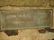
John Wood's Hospital
Sir Andrew Wood
Sir Andrew Wood, often referred to as the Scottish Nelson, made his name in battles against the English fleet in the years around 1500, and in recognition of his feats he was given estates in this part of Fife by James IIIJames III of Scotland
James III was King of Scots from 1460 to 1488. James was an unpopular and ineffective monarch owing to an unwillingness to administer justice fairly, a policy of pursuing alliance with the Kingdom of England, and a disastrous relationship with nearly all his extended family.His reputation as the...
.
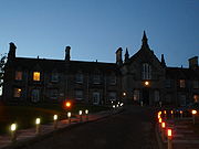
He lived in the mediaeval Largo House, of which only a tower now remains, three hundred yards west of the Parish Church. The oldest part of today's church dates back to 1623, but it was clearly built on the site of an earlier one. Sir Andrew linked his house and the church with what is believed to be Scotland's earliest canal, built so he could be rowed to church in his personal barge each Sunday in a manner befitting a naval hero.
Largo House
The fortalice of the medieval Largo House was replaced as the laird's residence by the nearby Palladian Largo House built c. 1750 by James Durham. This now stands as a shell after being partially demolished by Charles Brand of Dundee Ltd in 1951, on the instructions of the owners, the Maitland-Makgill-Crichton family of Monzie Castle, Crieff, to avoid having to pay rates. The main block of the house is attributed to James Adam but recent research indicates that it may actually have been designed by John Douglas, an equally important architect and contemporary of the Adams. Further wings were added in 1814 and 1831 by General James Durham, who had his coat of arms placed on the tympanumTympanum (architecture)
In architecture, a tympanum is the semi-circular or triangular decorative wall surface over an entrance, bounded by a lintel and arch. It often contains sculpture or other imagery or ornaments. Most architectural styles include this element....
.
Largo Law
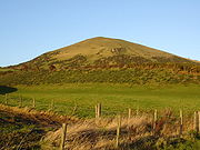
Volcanic plug
A volcanic plug, also called a volcanic neck or lava neck, is a volcanic landform created when magma hardens within a vent on an active volcano. When forming, a plug can cause an extreme build-up of pressure if volatile-charged magma is trapped beneath it, and this can sometimes lead to an...
. It is easily ascended from Upper Largo, to the south, starting at NO 423037, where there is a cemetery, an information board and parking space. The route passes between the steadings of Chesterstone Farm before directly ascending the hill's steep south face.