

Unity Ranger Station
Encyclopedia
The Unity Ranger Station is a United States Forest Service
compound consisting of five buildings and a lookout tower in the Wallowa-Whitman National Forest
of northeastern Oregon
. For many years, it was the administrative headquarters for the Unity Ranger District. It is located in the small unincorporated community of Unity, Oregon
. The historic structures were built in the rustic
style by the Civilian Conservation Corps
between 1936 and 1938. Today, the ranger station is only used during the summer months to house Forest Service fire crews. The ranger station is listed on the National Register of Historic Places
.
, the Forest Service built district ranger stations at strategic locations within the forest to house full-time employees and provide logistics support to fire patrols and project crews working in remote areas of the forest. After World War II
, the Forest Service greatly expanded its road network, allowing employees to get to most forest areas within a few hours. As a result, many of the more isolated ranger stations were closed or converted to summer guard stations.
The Whitman National Forest
was established in 1908. The Unity Ranger District was an administrative subdivision of the Whitman National Forest, with responsibility for 194000 acre of forest land in the Blue Mountains
of northeastern Oregon. After the Forest Service reorganization in 1954, the Unity Ranger District became part of the much larger Wallowa-Whitman National Forest.
The Civilian Conservation Corps
began doing construction work at the ranger station in 1936. Between 1936 and 1938, Civilian Conservation Corps crews built a number of ranger station buildings. The construction crews worked under the supervision of Forest Service rangers. All of the buildings constructed during that period were designed by the Forest Service's Pacific Northwest Regional Architecture Group, and were built in the Cascadian rustic style.
In 1953, two buildings were moved to the ranger station from the John Day Experiment Station, a Forest Service research site on the Blue Mountains. This gave the ranger station a second ranger residence and a bunkhouse
. Both of the buildings were constructed by the Civilian Conservation Corps under the supervision of Forest Service rangers at about the same time as the original ranger station structures. The two experiment station buildings have the same architectural characteristics as the original ranger station structures and were built using the same materials and methods.
The Unity Ranger Station served as a district headquarters until 2002, when the Unity district and two other ranger districts were merged and the headquarters was moved to Baker City, Oregon
. However, a full time visitor center remained open at the site until 2009. Today, the Unity Ranger Station is only open during the summer months, when the facilities are used to house Forest Service fire fighters.
There are six historically important structures that make up the ranger station complex. The historic buildings are all in excellent condition and are still used by Forest Service employees during the summer fire season. Because the Unity Ranger Station is of unique historic value as an early Forest Service ranger station, the compound was listed on the National Register of Historic Places on 11 April 1986. All of the historic buildings are located in close proximity to one another so the historic district covers just 1 acres (4,046.9 m²).
, a garage
, and a fire lookout tower
. The buildings were constructed in the Cascadian rustic architectural style using a wood-frame structure on a concrete foundation with clapboard
, wood shingles
, native lava
stone, and concrete
as the principal building materials. Many of the gables and shutters have the "open pine tree" logo common to Forest Service structures built during the 1930s.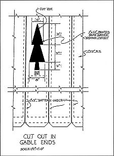
surrounded by the Wallowa-Whitman National Forest. Today, the historic ranger station is part of the Whitman Ranger District. The area of the Whitman Ranger District that used to be administered from the Unity Ranger Station is the southern part of the Wallowa-Whitman National Forest. The elevation at the ranger station is 4038 feet (1,230.8 m) above sea level. The forest around the ranger station is dominated by large stands of Ponderosa pine
.
Unity is 48 miles (77.2 km) southwest of Baker City on Oregon Route 245
. John Day, Oregon
, is 49 miles (78.9 km) west of Unity on U.S. Highway 26. Vale, Oregon
, is 65 miles (104.6 km) southeast of Unity on U.S. 26. The historic Unity Ranger Station compound is on the south side of Main Street (U.S. 26) near the center of the Unity town site.
United States Forest Service
The United States Forest Service is an agency of the United States Department of Agriculture that administers the nation's 155 national forests and 20 national grasslands, which encompass...
compound consisting of five buildings and a lookout tower in the Wallowa-Whitman National Forest
Wallowa-Whitman National Forest
The Wallowa–Whitman National Forest is a United States National Forest in Oregon. Formed by a merger of the formerly separate Wallowa and Whitman national forests, it is located in the northeastern corner of the state, in Wallowa, Baker, Union, Grant, and Umatilla counties in Oregon, and includes...
of northeastern Oregon
Oregon
Oregon is a state in the Pacific Northwest region of the United States. It is located on the Pacific coast, with Washington to the north, California to the south, Nevada on the southeast and Idaho to the east. The Columbia and Snake rivers delineate much of Oregon's northern and eastern...
. For many years, it was the administrative headquarters for the Unity Ranger District. It is located in the small unincorporated community of Unity, Oregon
Unity, Oregon
Unity is a city in Baker County, Oregon, United States, located in the Burnt River Valley. The population was 131 at the 2000 census.-History:While the town was never platted, a post office was established in Unity in 1891...
. The historic structures were built in the rustic
National Park Service Rustic
National Park Service rustic, also colloquially known as Parkitecture, is a style of architecture that arose in the United States National Park System to create buildings that harmonized with their natural environment. Since its founding, the National Park Service consistently has sought to provide...
style by the Civilian Conservation Corps
Civilian Conservation Corps
The Civilian Conservation Corps was a public work relief program that operated from 1933 to 1942 in the United States for unemployed, unmarried men from relief families, ages 18–25. A part of the New Deal of President Franklin D...
between 1936 and 1938. Today, the ranger station is only used during the summer months to house Forest Service fire crews. The ranger station is listed on the National Register of Historic Places
National Register of Historic Places
The National Register of Historic Places is the United States government's official list of districts, sites, buildings, structures, and objects deemed worthy of preservation...
.
History
In the early 20th century, the forest road networks were not well developed. To facilitate work in National ForestsUnited States National Forest
National Forest is a classification of federal lands in the United States.National Forests are largely forest and woodland areas owned by the federal government and managed by the United States Forest Service, part of the United States Department of Agriculture. Land management of these areas...
, the Forest Service built district ranger stations at strategic locations within the forest to house full-time employees and provide logistics support to fire patrols and project crews working in remote areas of the forest. After World War II
World War II
World War II, or the Second World War , was a global conflict lasting from 1939 to 1945, involving most of the world's nations—including all of the great powers—eventually forming two opposing military alliances: the Allies and the Axis...
, the Forest Service greatly expanded its road network, allowing employees to get to most forest areas within a few hours. As a result, many of the more isolated ranger stations were closed or converted to summer guard stations.
The Whitman National Forest
Whitman National Forest
Whitman National Forest was established in Oregon on July 1, 1908 with from part of Blue Mountains National Forest. On June 20, 1920 part of Minam National Forest was added. In 1954 it was administratively combined with Wallowa National Forest to make Wallowa–Whitman National Forest...
was established in 1908. The Unity Ranger District was an administrative subdivision of the Whitman National Forest, with responsibility for 194000 acre of forest land in the Blue Mountains
Blue Mountains (Oregon)
The Blue Mountains are a mountain range in the western United States, located largely in northeastern Oregon and stretching into southeastern Washington...
of northeastern Oregon. After the Forest Service reorganization in 1954, the Unity Ranger District became part of the much larger Wallowa-Whitman National Forest.
The Civilian Conservation Corps
Civilian Conservation Corps
The Civilian Conservation Corps was a public work relief program that operated from 1933 to 1942 in the United States for unemployed, unmarried men from relief families, ages 18–25. A part of the New Deal of President Franklin D...
began doing construction work at the ranger station in 1936. Between 1936 and 1938, Civilian Conservation Corps crews built a number of ranger station buildings. The construction crews worked under the supervision of Forest Service rangers. All of the buildings constructed during that period were designed by the Forest Service's Pacific Northwest Regional Architecture Group, and were built in the Cascadian rustic style.
In 1953, two buildings were moved to the ranger station from the John Day Experiment Station, a Forest Service research site on the Blue Mountains. This gave the ranger station a second ranger residence and a bunkhouse
Bunkhouse
A bunkhouse is a hostel or barracks-like building that historically was used to house working cowboys on ranches in North America. As most cowboys were young single men, the standard bunkhouse was a large open room with narrow beds or cots for each individual and little privacy...
. Both of the buildings were constructed by the Civilian Conservation Corps under the supervision of Forest Service rangers at about the same time as the original ranger station structures. The two experiment station buildings have the same architectural characteristics as the original ranger station structures and were built using the same materials and methods.
The Unity Ranger Station served as a district headquarters until 2002, when the Unity district and two other ranger districts were merged and the headquarters was moved to Baker City, Oregon
Baker City, Oregon
Baker City is a city in and the county seat of Baker County, Oregon, United States. It was named after Edward D. Baker. The population was 9,828 at the 2010 census.-History:...
. However, a full time visitor center remained open at the site until 2009. Today, the Unity Ranger Station is only open during the summer months, when the facilities are used to house Forest Service fire fighters.
There are six historically important structures that make up the ranger station complex. The historic buildings are all in excellent condition and are still used by Forest Service employees during the summer fire season. Because the Unity Ranger Station is of unique historic value as an early Forest Service ranger station, the compound was listed on the National Register of Historic Places on 11 April 1986. All of the historic buildings are located in close proximity to one another so the historic district covers just 1 acres (4,046.9 m²).
Structures
With six historic structures, the Unity Ranger Station is a classic Forest Service range station. All of the historic buildings were built by the Civilian Conservation Corps between 1936 and 1938. Their work included two ranger residences, a bunkhouse, an equipment warehouseWarehouse
A warehouse is a commercial building for storage of goods. Warehouses are used by manufacturers, importers, exporters, wholesalers, transport businesses, customs, etc. They are usually large plain buildings in industrial areas of cities and towns. They usually have loading docks to load and unload...
, a garage
Garage (house)
A residential garage is part of a home, or an associated building, designed or used for storing a vehicle or vehicles. In some places the term is used synonymously with "carport", though that term normally describes a structure that is not completely enclosed.- British residential garages:Those...
, and a fire lookout tower
Fire lookout tower
A fire lookout tower, fire tower or lookout tower, provides housing and protection for a person known as a "fire lookout" whose duty it is to search for wildfires in the wilderness...
. The buildings were constructed in the Cascadian rustic architectural style using a wood-frame structure on a concrete foundation with clapboard
Clapboard (architecture)
Clapboard, also known as bevel siding or lap siding or weather-board , is a board used typically for exterior horizontal siding that has one edge thicker than the other and where the board above laps over the one below...
, wood shingles
Shake (shingle)
A shake is a basic wooden shingle that is made from split logs. Shakes have traditionally been used for roofing and siding applications around the world. Higher grade shakes are typically used for roofing purposes, while the lower grades are used for siding purposes...
, native lava
Lava
Lava refers both to molten rock expelled by a volcano during an eruption and the resulting rock after solidification and cooling. This molten rock is formed in the interior of some planets, including Earth, and some of their satellites. When first erupted from a volcanic vent, lava is a liquid at...
stone, and concrete
Concrete
Concrete is a composite construction material, composed of cement and other cementitious materials such as fly ash and slag cement, aggregate , water and chemical admixtures.The word concrete comes from the Latin word...
as the principal building materials. Many of the gables and shutters have the "open pine tree" logo common to Forest Service structures built during the 1930s.
- The first ranger residence (building #1501) was built at the ranger station by the Civilian Conservation Corps. It is an L-shaped, one-story wood-frame building on a concrete foundation. It has a gableGableA gable is the generally triangular portion of a wall between the edges of a sloping roof. The shape of the gable and how it is detailed depends on the structural system being used and aesthetic concerns. Thus the type of roof enclosing the volume dictates the shape of the gable...
d roof with a hipHip roofA hip roof, or hipped roof, is a type of roof where all sides slope downwards to the walls, usually with a fairly gentle slope. Thus it is a house with no gables or other vertical sides to the roof. A square hip roof is shaped like a pyramid. Hip roofs on the houses could have two triangular side...
extension on the east end. There are decorative pine tree logo cut outs on the north and west gable ends. The building's exterior is covered with clapboard except the gable ends which have vertical board and batten siding. There is a red lava stone chimney on the of west side of the building. The roof extends out past the walls to cover porches on the north and east sides of the building. The porch roofs are supported by square timber posts. The residence has a combination of six-over-six double-hung sash windows and four-over-four double-hung sash windows. There have been no significant alterations to the exterior structure of the building.
- Near residence #1501, there is a small rectangular residential garage. It is a one-story wood-frame building on a poured concrete foundation. It has a gabled roof covered with wood shingles. The garage has horizontal lapped siding with vertical board and batten at the gable ends. An overhead-lift type vehicle-entry door is located on the west side of the building. There is also a regular entry door on the north. The garage’s exterior siding was replaced in 1983 using the same kind of material as the original.
- The Unity Ranger Station equipment warehouse is a wood-frame structure, built at the site by the Civilian Conservation Corps. The foundation is concrete with a stone veneer. It has a wood-shingled gabled roof with a large projecting gable that gives the building an L-shape. There is a vehicle entrance below the projecting gable. There is a red lava stone chimney off-center on the south roof slope. The main roof extends out on the north side of the building to cover the porch. The porch roof is supported by square timber posts. The exterior siding is horizontal clapboard with vertical board and batten siding at the gable ends. Windows are the single-sash type. There is a decorative pine tree logo cut out just below the peak on the projecting gable.
- A second residence (building #1052) was built by the Civilian Conservation Corps at the John Day Experiment Station sometime between 1936 and 1938. It was moved to the ranger station in 1953. It is an L-shaped, -story wood-frame structure on a concrete foundation. It has a high gabled roof with larger gabled dormers on the south side (rear) of the structure. There is a large offset gable on the northeast corner and shed-type roof over the front porch which is located on the north side of the building. The porch roof is supported by round peeled-log posts. There is a brick chimney on the south side of the house and a concrete chimney on the north side. The exterior siding is horizontal clapboard with wooden corner trim and vertical board and batten siding at the gable ends. The residence has six-over-six double-hung sash windows. There are decorative pine tree logo cut outs just below the peak on the north, east, and west gable ends of the building.
- Like residence #1052, the bunkhouse was originally constructed at the John Day Experiment Station in the mid-1930s, and moved to the ranger station in 1953. The bunkhouse is a -story, rectangular building. It has a wood-frame, concrete foundation, and a high gabled roof with wooden-shingles. It has two large gable dormers on the front roof slope. There are also two cement chimneys that straddle the roof ridge. The exterior siding is horizontal clapboard with vertical board and batten siding at the gable ends. The bunkhouse has six-over-six double-hung sash windows. There are decorative pine tree logo cut outs just below the peak on the east and west gable ends of the building and at the crest of the two dormers.
- The Unity Ranger Station has a combined fire lookout and water tower located on the compound. The 60 feet (18.3 m) high, wooden tower was built by the Civilian Conservation Corps in 1938. The tower has a 7 feet (2.1 m) by 7 feet (2.1 m) cab mounted on a 12 feet (3.7 m) square deck with a catwalk enclosed by simple wooden railing. The windows have top-hinged, wooden shutters that help shade the cab when open. The tower is built with creosoteCreosoteCreosote is the portion of chemical products obtained by the distillation of a tar that remains heavier than water, notably useful for its anti-septic and preservative properties...
treated Douglas-firDouglas-firDouglas-fir is one of the English common names for evergreen coniferous trees of the genus Pseudotsuga in the family Pinaceae. Other common names include Douglas tree, and Oregon pine. There are five species, two in western North America, one in Mexico, and two in eastern Asia...
timbers. There is a wooden stairway leading up to the cab. There is a wooden water tank located just below the cab. The tower structure has never been modified so it remains true to its original design.
Location
The Unity Ranger Station is located in the small unincorporated community of Unity, Oregon. Unity is in southwestern corner of Baker County, OregonBaker County, Oregon
Baker County is a county located in the U.S. state of Oregon. It is included in the 8 county definition of Eastern Oregon. It is named for Edward Dickinson Baker, a senator from Oregon who was killed at Ball's Bluff, a battle of the Civil War in Virginia in 1861. It was split from the eastern part...
surrounded by the Wallowa-Whitman National Forest. Today, the historic ranger station is part of the Whitman Ranger District. The area of the Whitman Ranger District that used to be administered from the Unity Ranger Station is the southern part of the Wallowa-Whitman National Forest. The elevation at the ranger station is 4038 feet (1,230.8 m) above sea level. The forest around the ranger station is dominated by large stands of Ponderosa pine
Ponderosa Pine
Pinus ponderosa, commonly known as the Ponderosa Pine, Bull Pine, Blackjack Pine, or Western Yellow Pine, is a widespread and variable pine native to western North America. It was first described by David Douglas in 1826, from eastern Washington near present-day Spokane...
.
Unity is 48 miles (77.2 km) southwest of Baker City on Oregon Route 245
Oregon Route 245
Oregon Route 245 is an Oregon state highway running from Salisbury to Unity. OR 245 is known as the Dooley Mountain Highway No. 415...
. John Day, Oregon
John Day, Oregon
John Day is a city located about north of Canyon City in Grant County, Oregon, at the intersection of U.S. Routes 26 and 395. The city was named for the nearby John Day River, which had been named for a Virginian member of the 1811 Astor Expedition, John Day...
, is 49 miles (78.9 km) west of Unity on U.S. Highway 26. Vale, Oregon
Vale, Oregon
Vale is a city in Malheur County, Oregon, United States, about west of the Idaho border. It is at the intersection of U.S. Routes 20 and 26, on the Malheur River.Vale was selected as Malheur's county seat in 1955, 68 years after the county was founded...
, is 65 miles (104.6 km) southeast of Unity on U.S. 26. The historic Unity Ranger Station compound is on the south side of Main Street (U.S. 26) near the center of the Unity town site.