Umpqua National Forest
Encyclopedia

Oregon
Oregon is a state in the Pacific Northwest region of the United States. It is located on the Pacific coast, with Washington to the north, California to the south, Nevada on the southeast and Idaho to the east. The Columbia and Snake rivers delineate much of Oregon's northern and eastern...
's Cascade mountains, covers an area of one-million acres (4,000 km2) in Douglas
Douglas County, Oregon
-National protected areas:* Crater Lake National Park * Rogue River-Siskiyou National Forest * Siuslaw National Forest * Umpqua National Forest * Willamette National Forest -Adjacent counties:* Lane County, Oregon -...
, Lane
Lane County, Oregon
-National protected areas:*Oregon Islands National Wildlife Refuge *Siuslaw National Forest *Umpqua National Forest *Willamette National Forest -Government:...
, and Jackson Counties
Jackson County, Oregon
-National protected areas:* Cascade–Siskiyou National Monument* Crater Lake National Park * Klamath National Forest * Rogue River-Siskiyou National Forest * Umpqua National Forest -Demographics:...
, and borders Crater Lake National Park
Crater Lake National Park
Crater Lake National Park is a United States National Park located in southern Oregon. Established in 1902, Crater Lake National Park is the sixth oldest national park in the United States and the only one in the state of Oregon...
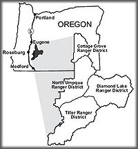
. The four ranger districts that comprise the Forest are Cottage Grove, Diamond Lake, North Umpqua, and Tiller Ranger Districts. The Forest is managed by the United States Forest Service
United States Forest Service
The United States Forest Service is an agency of the United States Department of Agriculture that administers the nation's 155 national forests and 20 national grasslands, which encompass...
, headquartered in Roseburg
Roseburg, Oregon
Roseburg is a city in the U.S. state of Oregon. It is the county seat of Douglas County. The population was 21,181 at the 2010 census.-History:...
.
Geography
Stands of hemlockHemlock
The word hemlock may refer to:*Hemlock, several poisonous plants in the Apiaceae family :**Hemlock , two species, one formerly used as a method of execution**Water Hemlock...
, true fir, Douglas-fir and cedar transition to lower elevation forests of mixed conifers and hardwoods. Timbered valleys of old-growth ponderosa and groves of oak separate mountains like the 9182 feet (2,798.7 m) Mount Thielsen
Mount Thielsen
Mount Thielsen, or Big Cowhorn, is an extinct shield volcano in the Oregon High Cascades, near Mount Bailey. Because Mount Thielsen stopped erupting 250,000 years ago, glaciers have heavily eroded the volcano's structure, creating precipitous slopes and its horn-like peak...
and the 8363 feet (2,549 m) Mount Bailey
Mount Bailey
Mount Bailey can refer to:* Mount Bailey * Mount Bailey , United States* Mount Bailey , United States...
. Notable geologic features include volcanic basalt and andesite monolithic spires with descriptive names like Eagle Rock, Rattlesnake Rock, and Old Man.
History
Ancestors of the Umpqua, Southern Molalla, Yoncalla, and Cow Creek Band of Umpqua Tribe of Indians lived here before Mount MazamaMount Mazama
Mount Mazama is a destroyed stratovolcano in the Oregon part of the Cascade Volcanic Arc and the Cascade Range. The volcano's collapsed caldera holds Crater Lake, and the entire mountain is located within Crater Lake National Park....
erupted forming Crater Lake
Crater Lake
Crater Lake is a caldera lake located in the south-central region of the U.S. state of Oregon. It is the main feature of Crater Lake National Park and famous for its deep blue color and water clarity. The lake partly fills a nearly deep caldera that was formed around 7,700 years agoby the...
nearly 7,000 years ago. The Indians were moved to reservations in 1856. As Europeans bought reservation lands, the tribes further fragmented to become farmers and ranchers in the Umpqua Valley. Two translations of the word "umpqua" are "thundering waters" and "across the waters".
The Umpqua National Forest was created by Congress on July 1, 1908. The Forest Service staff soon began building trails, constructing bridges, fighting fires, monitoring grazing, and erecting lookouts. Logging and mining began in 1925. The Civilian Conservation Corps was active in the Umpqua National Forest by building roads, bridges and recreation facilities in the 1930s.
Points of interest
Umpqua National Forest is home to more than 250 wildlife species. Large mammals such as elkElk
The Elk is the large deer, also called Cervus canadensis or wapiti, of North America and eastern Asia.Elk may also refer to:Other antlered mammals:...
, deer
Deer
Deer are the ruminant mammals forming the family Cervidae. Species in the Cervidae family include white-tailed deer, elk, moose, red deer, reindeer, fallow deer, roe deer and chital. Male deer of all species and female reindeer grow and shed new antlers each year...
, black bear
American black bear
The American black bear is a medium-sized bear native to North America. It is the continent's smallest and most common bear species. Black bears are omnivores, with their diets varying greatly depending on season and location. They typically live in largely forested areas, but do leave forests in...
, and cougar, as well as the smaller residents, squirrels, fox
Fox
Fox is a common name for many species of omnivorous mammals belonging to the Canidae family. Foxes are small to medium-sized canids , characterized by possessing a long narrow snout, and a bushy tail .Members of about 37 species are referred to as foxes, of which only 12 species actually belong to...
, raccoons, and bat
Bat
Bats are mammals of the order Chiroptera "hand" and pteron "wing") whose forelimbs form webbed wings, making them the only mammals naturally capable of true and sustained flight. By contrast, other mammals said to fly, such as flying squirrels, gliding possums, and colugos, glide rather than fly,...
s are supported by the diverse forest habitats. Raptors such as owls
OWLS
OWLS is a mnemonic used by general aviation airplane pilots to assess an unprepared surface for a precautionary landing.Like all mnemonics this check has become part of aviation culture and folklore.OWLS:* Obstacles* Wind direction...
, eagle
Eagle
Eagles are members of the bird family Accipitridae, and belong to several genera which are not necessarily closely related to each other. Most of the more than 60 species occur in Eurasia and Africa. Outside this area, just two species can be found in the United States and Canada, nine more in...
s, osprey
Osprey
The Osprey , sometimes known as the sea hawk or fish eagle, is a diurnal, fish-eating bird of prey. It is a large raptor, reaching more than in length and across the wings...
, and even peregrine falcons can occasionally be seen in the forest. Coho and Chinook salmon
Salmon
Salmon is the common name for several species of fish in the family Salmonidae. Several other fish in the same family are called trout; the difference is often said to be that salmon migrate and trout are resident, but this distinction does not strictly hold true...
and steelhead, rainbow, brown and cutthroat trout
Trout
Trout is the name for a number of species of freshwater and saltwater fish belonging to the Salmoninae subfamily of the family Salmonidae. Salmon belong to the same family as trout. Most salmon species spend almost all their lives in salt water...
swim, feed and spawn in the rivers and streams of the Forest.
A 1993 Forest Service study estimated that the extent of old growth in the Forest was 535300 acres (216,628.4 ha), 82200 acres (33,265.2 ha) of which were Mountain Hemlock
Mountain Hemlock
Tsuga mertensiana, known as Mountain Hemlock, is a species of hemlock native to the west coast of North America, with its northwestern limit on the Kenai Peninsula, Alaska, and its southeastern limit in northern Tulare County, California....
(Tsuga mertensiana) forests.
Recreational activities in the Forest include camping, fishing, hiking, horseback riding, mountain biking, rock climbing, and boating. Winter activities include both Nordic and downhill skiing, as well as snowshoeing and snowmobiling.
In 1988, the Oregon Omnibus Wild and Scenic Rivers Act designated a portion of the North Umpqua River
North Umpqua River
The North Umpqua River is a tributary of the Umpqua River, approximately long, in southwestern Oregon in the United States. It drains a scenic and rugged area of the Cascade Range southwest of Eugene, flowing through steep canyons and surrounded by large Douglas-fir forests...
a part of the Wild and Scenic River system. Twenty-six miles of the river run through the Forest.
The Rogue-Umpqua National Scenic Byway
Rogue-Umpqua Scenic Byway
The Rogue-Umpqua Scenic Byway is a National Scenic Byway in the U.S. state of Oregon. It provides a tour of the environs of the North Umpqua River, the High Cascades, and the Upper Rogue River.- Route description :...
extends 172 miles (276.8 km) through the Rogue River and Umpqua National Forests, as well as the Medford
Medford, Oregon
Medford is a city in Jackson County, Oregon, United States. As of the 2010 US Census, the city had a total population of 74,907 and a metropolitan area population of 207,010, making the Medford MSA the 4th largest metro area in Oregon...
and Roseburg
Roseburg, Oregon
Roseburg is a city in the U.S. state of Oregon. It is the county seat of Douglas County. The population was 21,181 at the 2010 census.-History:...
districts of the Bureau of Land Management
Bureau of Land Management
The Bureau of Land Management is an agency within the United States Department of the Interior which administers America's public lands, totaling approximately , or one-eighth of the landmass of the country. The BLM also manages of subsurface mineral estate underlying federal, state and private...
and private lands.
Wilderness areas

Mount Thielsen
Mount Thielsen, or Big Cowhorn, is an extinct shield volcano in the Oregon High Cascades, near Mount Bailey. Because Mount Thielsen stopped erupting 250,000 years ago, glaciers have heavily eroded the volcano's structure, creating precipitous slopes and its horn-like peak...
.
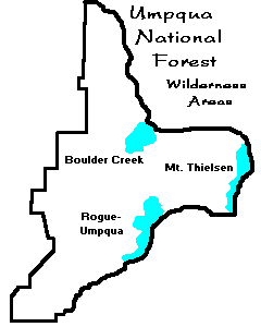
Boulder Creek
Boulder Creek is a 19100 acres (77.3 km²) Wilderness area located 50 miles (80.5 km) east of RoseburgRoseburg, Oregon
Roseburg is a city in the U.S. state of Oregon. It is the county seat of Douglas County. The population was 21,181 at the 2010 census.-History:...
. One popular area in Boulder Creek is Pine Bench. A flat area overlooking Boulder Creek, Pine Bench is home to a grove of majestic old growth Ponderosa pines. In 1996 the Spring Fire burned 16500 acres (66.8 km²) in the Boulder Creek Wilderness.
Rogue-Umpqua Divide
The Rogue-Umpqua Divide is a 33000 acres (133.5 km²) Wilderness area, 26350 acres (106.6 km²) of which is inside the National Forest. Located 80 miles (128.7 km) east of RoseburgRoseburg, Oregon
Roseburg is a city in the U.S. state of Oregon. It is the county seat of Douglas County. The population was 21,181 at the 2010 census.-History:...
, the Rogue-Umpqua Divide ranges in elevation from 3,200 to 6878 feet (2,096.4 m) and separates the drainages of the Rogue
Rogue River (Oregon)
The Rogue River in southwestern Oregon in the United States flows about in a generally westward direction from the Cascade Range to the Pacific Ocean. Known for its salmon runs, whitewater rafting, and rugged scenery, it was one of the original eight rivers named in the Wild and Scenic Rivers Act...
and Umpqua
Umpqua River
The Umpqua River on the Pacific coast of Oregon in the United States is approximately long. One of the principal rivers of the Oregon Coast and known for bass and shad, the river drains an expansive network of valleys in the mountains west of the Cascade Range and south of the Willamette Valley,...
rivers. The Wilderness includes sub-alpine meadows and old-growth forests.
Mount Thielsen
Mount ThielsenMount Thielsen
Mount Thielsen, or Big Cowhorn, is an extinct shield volcano in the Oregon High Cascades, near Mount Bailey. Because Mount Thielsen stopped erupting 250,000 years ago, glaciers have heavily eroded the volcano's structure, creating precipitous slopes and its horn-like peak...
is a 55100 acres (223 km²) Wilderness area, 21593 acres (87.4 km²) of which is located inside the National Forest. Located 80 miles (128.7 km) east of Roseburg
Roseburg, Oregon
Roseburg is a city in the U.S. state of Oregon. It is the county seat of Douglas County. The population was 21,181 at the 2010 census.-History:...
, this Wilderness area is the largest in the Umpqua. The 9182 feet (2,798.7 m) Mt. Thielsen was born of the same volcanic activity that created Crater Lake
Crater Lake
Crater Lake is a caldera lake located in the south-central region of the U.S. state of Oregon. It is the main feature of Crater Lake National Park and famous for its deep blue color and water clarity. The lake partly fills a nearly deep caldera that was formed around 7,700 years agoby the...
and some trails pass over deep pumice that was deposited when Mt. Mazama erupted. The Pacific Crest Trail
Pacific Crest Trail
The Pacific Crest Trail is a long-distance mountain hiking and equestrian trail on the Western Seaboard of the United States. The southern terminus is at the California border with Mexico...
passes through the middle of the Wilderness area.

