

U.S. Route 93 in Arizona
Encyclopedia
In the U.S. state
of Arizona
, U.S. Route 93 is a U.S. Highway that begins in Wickenburg
and heads north to the Nevada
border at the Mike O'Callaghan – Pat Tillman Memorial Bridge.
As part of a proposal by municipal leaders in Nevada and Arizona, the highway could be replaced by Interstate 11
.
 The southern terminus of US 93 is located at a junction with US 60 in Wickenburg, a small town about 50 miles (80 km) northwest of Phoenix
. It heads towards the northwest from this junction to an intersection with SR 89 northwest of Wickenburg. SR 89 heads north to Prescott
while US 93 continues its northwesterly heading, as a largely two-lane highway with passing lanes every few miles. US 93 continues to the northwest to a junction with SR 71 at a diamond interchange southwest of Congress
. As it continues to the northwest, the highway is known as the Joshua Tree Forest Parkway.
The highway widens to four lanes at the Santa Maria River
and continues towards the northwest to a junction with SR 97
prior to passing through the town of Wikieup
. On the way, it passes the tiny settlement of Nothing, Arizona
and crosses Burro Creek over a steel arch bridge about 390 feet over the creek.
After passing through Wikieup, US 93 curves towards the north to merge with I-40
at exit 71 (narrowing back to a two-lane highway with passing lanes every few miles; construction is underway as of the fall of 2009 to convert this stretch to four lanes).
After US 93 and I-40 merge, they share the same alignment heading west until they reach Kingman
. The two split in Kingman with I-40 heading towards the southwest towards California
and US 93 heading towards the northwest towards Las Vegas
.
Northwest of Kingman, US 93 has an interchange with SR 68. US 93 continues as a four-lane route towards the northwest and as it nears the Nevada
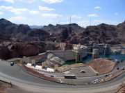
border, it reaches the Mike O'Callaghan – Pat Tillman Memorial Bridge over the Black Canyon
and crosses next to the Hoover Dam.
US 93 continues into Nevada to the cities of Boulder City
, Henderson
and Las Vegas.
In 1965, Arizona proposed for an extension of US 93 from Kingman to Ash Fork
, overlapping US 66, and then south to Phoenix
. This proposal was protested by the towns of Aguila
and Wickenburg
that argued that US 93 should pass through their towns rather than the proposed alignment to the east. The town of Wickenburg contested that a direct routing between Phoenix and Kingman would be 100 miles (161 km) shorter than the routing through Ash Fork and that it would provide a necessary connection between Phoenix, the state capital, and the northwestern part of the state.
Until 1992, US 93 ended a short distance north of Wickenburg, Arizona
at a junction with U.S. Route 89. When US 89 was decommissioned in the area, the US 93 designation was carried on into Wickenburg.
(and is an officially designated portion of the CANAMEX Corridor
). Upgrades of US 60 and US 93 to four-lane expressway status are scheduled between Las Vegas and Phoenix; as of the fall of 2009, most sections north of the Santa Maria River are already at four-lane expressway status (with some of the newest portions presumably built to Interstate standards) with construction ongoing. This routing is part of a proposed Interstate 11
which could potentially connect Interstate 10
west of Phoenix with Interstate 515
southeast of Las Vegas.
A segment of this new highway consists of a new route across the Colorado River
called the Hoover Dam Bypass
. The new crossing is the Mike O'Callaghan-Pat Tillman Memorial Bridge, the first so-called concrete-steel composite arch bridge built in the United States. The bridge is 1900 feet (579 m) with a 1080 feet (329 m) main span. The roadway is 840 feet (256 m) above the river.
The bypass replaced the old section of U.S. 93 that approached and crossed directly over Hoover Dam, which was inadequate by modern standards, because there was one narrow lane in each direction, including several hairpin turn
s, many dangerous curves, and poor sight distances. Also, in the wake of the September 11, 2001 attacks
, truck traffic over the Hoover Dam had been diverted south to a river crossing near Laughlin
, Nevada
, in an effort to safeguard the dam from hazardous spills or explosions.
|Maricopa
|Wickenburg
|0.00
| – Los Angeles, Quartzsite, Phoenix
|
|-
|rowspan=3|Yavapai
|
|6.04
|
|
|-
|
|16.75
| – Quartzsite, Prescott
|Interchange
|-
|
|44.44
|
|
|-
|rowspan=9|Mohave
|
|59.03
|colspan=2 align=center|Burro Creek Bridge over Burro Creek
|-
|
|106.80
|
|Interchange; south end of I-40 overlap
|-
|
|
|Blake Ranch Road
|Interchange (exit 66)
|-
|
|
|DW Ranch Road
|Interchange (exit 59)
|-
|rowspan=3|Kingman
|
|
|Interchange (exit 53)
|-
|
|Stockton Hill Road
|Interchange (exit 51)
|-
|129.65
| – Los Angeles
|Interchange; north end of I-40 overlap
|-
|
|133.68
|, Laughlin
|Interchange (exit 67)
|-
|
|200.13
|colspan=2 align=center|Mike O'Callaghan – Pat Tillman Memorial Bridge over the Colorado River
(Nevada state line)
U.S. state
A U.S. state is any one of the 50 federated states of the United States of America that share sovereignty with the federal government. Because of this shared sovereignty, an American is a citizen both of the federal entity and of his or her state of domicile. Four states use the official title of...
of Arizona
Arizona
Arizona ; is a state located in the southwestern region of the United States. It is also part of the western United States and the mountain west. The capital and largest city is Phoenix...
, U.S. Route 93 is a U.S. Highway that begins in Wickenburg
Wickenburg, Arizona
Wickenburg is a town in Maricopa County, Arizona, United States. According to 2006 Census Bureau estimates, the population of the town is 6,423.-Geography:Wickenburg is located at ....
and heads north to the Nevada
Nevada
Nevada is a state in the western, mountain west, and southwestern regions of the United States. With an area of and a population of about 2.7 million, it is the 7th-largest and 35th-most populous state. Over two-thirds of Nevada's people live in the Las Vegas metropolitan area, which contains its...
border at the Mike O'Callaghan – Pat Tillman Memorial Bridge.
As part of a proposal by municipal leaders in Nevada and Arizona, the highway could be replaced by Interstate 11
Interstate 11
Interstate 11 is a possible designation for a locally-proposed Interstate Highway in the United States to run from Tonopah, Arizona, northwest to Las Vegas, Nevada, by way of Kingman, Arizona. The designation is a local proposal that has not been accepted by AASHTO or FHWA, the agencies normally...
.
Route description
Phoenix, Arizona
Phoenix is the capital, and largest city, of the U.S. state of Arizona, as well as the sixth most populated city in the United States. Phoenix is home to 1,445,632 people according to the official 2010 U.S. Census Bureau data...
. It heads towards the northwest from this junction to an intersection with SR 89 northwest of Wickenburg. SR 89 heads north to Prescott
Prescott, Arizona
Prescott is a city in Yavapai County, Arizona, USA. It was designated "Arizona's Christmas City" by Arizona Governor Rose Mofford in the late 1980s....
while US 93 continues its northwesterly heading, as a largely two-lane highway with passing lanes every few miles. US 93 continues to the northwest to a junction with SR 71 at a diamond interchange southwest of Congress
Congress, Arizona
Congress is a census-designated place in Yavapai County, Arizona, United States. The population was 1,717 at the 2000 census. Congress, a gold-mining ghost town, now serves as a retirement and bedroom community for nearby Wickenburg.-History:...
. As it continues to the northwest, the highway is known as the Joshua Tree Forest Parkway.
The highway widens to four lanes at the Santa Maria River
Santa Maria River (Arizona)
The Santa Maria River is an intermittent stream located in western Arizona. It is a primary tributary of the Bill Williams River and one of the main sources of inflow for Alamo Lake...
and continues towards the northwest to a junction with SR 97
Arizona State Route 97
State Route 97 is a long state highway in the U.S. state of Arizona. It runs from U.S. Route 93 northwest of Congress northeast to SR 96 southeast of Bagdad. The road was built by the late 1930s and improved during the late 1940s...
prior to passing through the town of Wikieup
Wikieup, Arizona
Wikieup is a small unincorporated community located on U.S. Route 93 in Mohave County, Arizona. It is located approximately south of Interstate 40 and approximately northwest of Phoenix, Arizona. In 2000, the population of Wikieup's ZCTA was 305....
. On the way, it passes the tiny settlement of Nothing, Arizona
Nothing, Arizona
Nothing was a small unincorporated settlement in far eastern Mohave County, Arizona, United States with four inhabitants.-History:The locals told travelers it "got named by a bunch of drunks."...
and crosses Burro Creek over a steel arch bridge about 390 feet over the creek.
After passing through Wikieup, US 93 curves towards the north to merge with I-40
Interstate 40 in Arizona
Interstate 40 is an east–west Interstate Highway that has a section in the U.S. state of Arizona connecting sections in California to New Mexico. It enters Arizona from the west at a crossing of the Colorado River southwest of Kingman...
at exit 71 (narrowing back to a two-lane highway with passing lanes every few miles; construction is underway as of the fall of 2009 to convert this stretch to four lanes).
After US 93 and I-40 merge, they share the same alignment heading west until they reach Kingman
Kingman, Arizona
Kingman is located in a desert climate on the edge of the Mojave Desert, but its higher elevation and location between the Colorado Plateau and the Lower Colorado River Valley tempers summer high temperatures and contributes to winter cold and rare snowfall. Summer daytime highs reach above 90 °F ...
. The two split in Kingman with I-40 heading towards the southwest towards California
California
California is a state located on the West Coast of the United States. It is by far the most populous U.S. state, and the third-largest by land area...
and US 93 heading towards the northwest towards Las Vegas
Las Vegas, Nevada
Las Vegas is the most populous city in the U.S. state of Nevada and is also the county seat of Clark County, Nevada. Las Vegas is an internationally renowned major resort city for gambling, shopping, and fine dining. The city bills itself as The Entertainment Capital of the World, and is famous...
.
Northwest of Kingman, US 93 has an interchange with SR 68. US 93 continues as a four-lane route towards the northwest and as it nears the Nevada
Nevada
Nevada is a state in the western, mountain west, and southwestern regions of the United States. With an area of and a population of about 2.7 million, it is the 7th-largest and 35th-most populous state. Over two-thirds of Nevada's people live in the Las Vegas metropolitan area, which contains its...
border, it reaches the Mike O'Callaghan – Pat Tillman Memorial Bridge over the Black Canyon
Black Canyon of the Colorado
The Black Canyon of the Colorado is the canyon on the Colorado River where Hoover Dam was built. The canyon is located on the Colorado River at the state line between Nevada and Arizona. The western wall of the gorge is in the El Dorado Mountains, and the eastern wall is in the Black Mountains of...
and crosses next to the Hoover Dam.
US 93 continues into Nevada to the cities of Boulder City
Boulder City, Nevada
Boulder City is a city in Clark County, Nevada, United States. It is approximately from the City of Las Vegas. As of the 2010 census the population of Boulder City was 15,023.Boulder City is one of only two cities in Nevada that prohibit gambling....
, Henderson
Henderson, Nevada
-Demographics:According to the 2000 census, there were 175,381 people, 66,331 households, and 47,095 families residing in the city. The population density was 2,200.8 people per square mile . There were 71,149 housing units at an average density of 892.8 per square mile...
and Las Vegas.
History
The route between Kingman and Hoover Dam first became part of the state highway system in 1934 when it was designated as SR 69. At the time, Hoover Dam was still under construction and the highway did not link to Nevada. The dam was completed the following year in 1935 enabling traffic to cross over the top of the dam. In that year, US 466 was designated over SR 69 from Kingman to Hoover Dam. US 93 was extended south from (then) US 91 at Glendale NV in 1951.In 1965, Arizona proposed for an extension of US 93 from Kingman to Ash Fork
Ash Fork, Arizona
Ash Fork is a census-designated place in Yavapai County, Arizona, United States. The population was 457 at the 2000 census.-Geography:Ash Fork is located at ....
, overlapping US 66, and then south to Phoenix
Phoenix, Arizona
Phoenix is the capital, and largest city, of the U.S. state of Arizona, as well as the sixth most populated city in the United States. Phoenix is home to 1,445,632 people according to the official 2010 U.S. Census Bureau data...
. This proposal was protested by the towns of Aguila
Aguila, Arizona
Aguila is a CDP in Maricopa County, Arizona, United States. It is located on U.S. Route 60 approximately 20 miles west of Wickenburg, or at approximately 50000 N. 510th Ave. Major economic activities include cantaloupe farming and formerly included mining. It uses the same street numbering system...
and Wickenburg
Wickenburg, Arizona
Wickenburg is a town in Maricopa County, Arizona, United States. According to 2006 Census Bureau estimates, the population of the town is 6,423.-Geography:Wickenburg is located at ....
that argued that US 93 should pass through their towns rather than the proposed alignment to the east. The town of Wickenburg contested that a direct routing between Phoenix and Kingman would be 100 miles (161 km) shorter than the routing through Ash Fork and that it would provide a necessary connection between Phoenix, the state capital, and the northwestern part of the state.
Until 1992, US 93 ended a short distance north of Wickenburg, Arizona
Wickenburg, Arizona
Wickenburg is a town in Maricopa County, Arizona, United States. According to 2006 Census Bureau estimates, the population of the town is 6,423.-Geography:Wickenburg is located at ....
at a junction with U.S. Route 89. When US 89 was decommissioned in the area, the US 93 designation was carried on into Wickenburg.
New Bypass Bridge
US 93 (with US 60 to the southeast of Wickenburg) is the shortest route (currently estimated to take an average of five hours) between the fast-growing cities of Las Vegas and Phoenix, two of the largest cities in the SouthwestSouthwestern United States
The Southwestern United States is a region defined in different ways by different sources. Broad definitions include nearly a quarter of the United States, including Arizona, California, Colorado, Nevada, New Mexico, Oklahoma, Texas and Utah...
(and is an officially designated portion of the CANAMEX Corridor
CANAMEX Corridor
The CANAMEX corridor is a corridor linking Canada to Mexico through the United States. The corridor was established under the North American Free Trade Agreement.Currently the corridor is defined by a series of highways...
). Upgrades of US 60 and US 93 to four-lane expressway status are scheduled between Las Vegas and Phoenix; as of the fall of 2009, most sections north of the Santa Maria River are already at four-lane expressway status (with some of the newest portions presumably built to Interstate standards) with construction ongoing. This routing is part of a proposed Interstate 11
Interstate 11
Interstate 11 is a possible designation for a locally-proposed Interstate Highway in the United States to run from Tonopah, Arizona, northwest to Las Vegas, Nevada, by way of Kingman, Arizona. The designation is a local proposal that has not been accepted by AASHTO or FHWA, the agencies normally...
which could potentially connect Interstate 10
Interstate 10
Interstate 10 is the fourth-longest Interstate Highway in the United States, after I-90, I-80, and I-40. It is the southernmost east–west, coast-to-coast Interstate Highway, although I-4 and I-8 are further south. It stretches from the Pacific Ocean at State Route 1 in Santa Monica,...
west of Phoenix with Interstate 515
Interstate 515
Interstate 515 is a spur of Interstate 15 that runs from the junction of I-15, US 93 and US 95 near Downtown Las Vegas, Nevada approximately southeast to Railroad Pass near the borders of Henderson and Boulder City....
southeast of Las Vegas.
A segment of this new highway consists of a new route across the Colorado River
Colorado River
The Colorado River , is a river in the Southwestern United States and northwestern Mexico, approximately long, draining a part of the arid regions on the western slope of the Rocky Mountains. The watershed of the Colorado River covers in parts of seven U.S. states and two Mexican states...
called the Hoover Dam Bypass
Hoover Dam Bypass
The Mike O'Callaghan – Pat Tillman Memorial Bridge, the key component to the Hoover Dam Bypass project, was the first concrete-steel composite arch bridge built in the United States, and it incorporates the longest concrete arch bridge in the Western Hemisphere. Opened on October 19, 2010,...
. The new crossing is the Mike O'Callaghan-Pat Tillman Memorial Bridge, the first so-called concrete-steel composite arch bridge built in the United States. The bridge is 1900 feet (579 m) with a 1080 feet (329 m) main span. The roadway is 840 feet (256 m) above the river.
The bypass replaced the old section of U.S. 93 that approached and crossed directly over Hoover Dam, which was inadequate by modern standards, because there was one narrow lane in each direction, including several hairpin turn
Hairpin turn
A hairpin turn , named for its resemblance to a hairpin/bobby pin, is a bend in a road with a very acute inner angle, making it necessary for an oncoming vehicle to turn almost 180° to continue on the road. Such turns in ramps and trails may be called switchbacks in American English, by analogy...
s, many dangerous curves, and poor sight distances. Also, in the wake of the September 11, 2001 attacks
September 11, 2001 attacks
The September 11 attacks The September 11 attacks The September 11 attacks (also referred to as September 11, September 11th or 9/119/11 is pronounced "nine eleven". The slash is not part of the pronunciation...
, truck traffic over the Hoover Dam had been diverted south to a river crossing near Laughlin
Laughlin, Nevada
Laughlin is a census-designated place in Clark County, Nevada, United States, and a port located on the Colorado River. Laughlin is south of Las Vegas, located in the far southern tip of Nevada. It is best known for its gaming, entertainment, and water recreation. As of the 2010 census, the...
, Nevada
Nevada
Nevada is a state in the western, mountain west, and southwestern regions of the United States. With an area of and a population of about 2.7 million, it is the 7th-largest and 35th-most populous state. Over two-thirds of Nevada's people live in the Las Vegas metropolitan area, which contains its...
, in an effort to safeguard the dam from hazardous spills or explosions.
Junction list
|-|Maricopa
Maricopa County, Arizona
-2010:Whereas according to the 2010 U.S. Census Bureau:*73.0% White*5.0% Black*2.1% Native American*3.5% Asian*0.2% Native Hawaiian or Pacific Islander*3.5% Two or more races*12.7% Other races*29.6% Hispanic or Latino -2000:...
|Wickenburg
Wickenburg, Arizona
Wickenburg is a town in Maricopa County, Arizona, United States. According to 2006 Census Bureau estimates, the population of the town is 6,423.-Geography:Wickenburg is located at ....
|0.00
| – Los Angeles, Quartzsite, Phoenix
|
|-
|rowspan=3|Yavapai
Yavapai County, Arizona
-2010:Whereas according to the 2010 U.S. Census Bureau:*89.3% White*0.6% Black*1.7% Native American*0.8% Asian*0.1% Native Hawaiian or Pacific Islander*2.5% Two or more races*5.0% Other races*13.6% Hispanic or Latino -2000:...
|
|6.04
|
|
|-
|
|16.75
| – Quartzsite, Prescott
|Interchange
|-
|
|44.44
|
|
|-
|rowspan=9|Mohave
Mohave County, Arizona
Mohave County is located in the northwestern corner of the U.S. state of Arizona. As of the 2010 census, its population was 200,186, an increase of 45,154 people since the 2000 census count of 155,032. The county seat is Kingman...
|
|59.03
|colspan=2 align=center|Burro Creek Bridge over Burro Creek
|-
|
|106.80
|
|Interchange; south end of I-40 overlap
|-
|
|
|Blake Ranch Road
|Interchange (exit 66)
|-
|
|
|DW Ranch Road
|Interchange (exit 59)
|-
|rowspan=3|Kingman
Kingman, Arizona
Kingman is located in a desert climate on the edge of the Mojave Desert, but its higher elevation and location between the Colorado Plateau and the Lower Colorado River Valley tempers summer high temperatures and contributes to winter cold and rare snowfall. Summer daytime highs reach above 90 °F ...
|
|
|Interchange (exit 53)
|-
|
|Stockton Hill Road
|Interchange (exit 51)
|-
|129.65
| – Los Angeles
Los Ángeles
Los Ángeles is the capital of the province of Biobío, in the commune of the same name, in Region VIII , in the center-south of Chile. It is located between the Laja and Biobío rivers. The population is 123,445 inhabitants...
|Interchange; north end of I-40 overlap
|-
|
|133.68
|, Laughlin
|Interchange (exit 67)
|-
|
|200.13
|colspan=2 align=center|Mike O'Callaghan – Pat Tillman Memorial Bridge over the Colorado River
Colorado River
The Colorado River , is a river in the Southwestern United States and northwestern Mexico, approximately long, draining a part of the arid regions on the western slope of the Rocky Mountains. The watershed of the Colorado River covers in parts of seven U.S. states and two Mexican states...
(Nevada state line)