
Congress, Arizona
Encyclopedia
Census-designated place
A census-designated place is a concentration of population identified by the United States Census Bureau for statistical purposes. CDPs are delineated for each decennial census as the statistical counterparts of incorporated places such as cities, towns and villages...
(CDP) in Yavapai County
Yavapai County, Arizona
-2010:Whereas according to the 2010 U.S. Census Bureau:*89.3% White*0.6% Black*1.7% Native American*0.8% Asian*0.1% Native Hawaiian or Pacific Islander*2.5% Two or more races*5.0% Other races*13.6% Hispanic or Latino -2000:...
, Arizona
Arizona
Arizona ; is a state located in the southwestern region of the United States. It is also part of the western United States and the mountain west. The capital and largest city is Phoenix...
, United States
United States
The United States of America is a federal constitutional republic comprising fifty states and a federal district...
. The population was 1,717 at the 2000 census. Congress, a gold-mining ghost town
Ghost town
A ghost town is an abandoned town or city. A town often becomes a ghost town because the economic activity that supported it has failed, or due to natural or human-caused disasters such as floods, government actions, uncontrolled lawlessness, war, or nuclear disasters...
, now serves as a retirement and bedroom community for nearby Wickenburg.
History
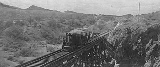
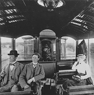
Gold was discovered at Congress in 1884. By 1893, the Santa Fe Railroad passed within three miles of the mine, at Congress Junction. Congress boomed, and remained prosperous until the mid-1930s, when the mines closed. Total gold production at the Congress MineCongress Mine
The Congress Mine is a gold mine located at the ghost town of Congress, Arizona on the southeastern slope of the Date Creek Mountains, approximately 18 miles north-northeast of Wickenburg, Arizona at an elevation of about 3,000 feet...
exceeded $8 million, at the then-current price of $20.67 per ounce—or about $400 million, at the 2007 price.
The post office moved to Congress Junction in 1938, where it remains. The community now known as Congress is the old Congress Junction. Little remains at the original townsite. Source:
Geography
Congress is located at 34°8′46"N 112°50′48"W (34.146068, -112.846533).According to the United States Census Bureau
United States Census Bureau
The United States Census Bureau is the government agency that is responsible for the United States Census. It also gathers other national demographic and economic data...
, the CDP has a total area of 37.7 square miles (97.6 km²), of which, 37.6 square miles (97.4 km²) of it is land and 0.04 square mile (0.1035995244 km²) of it (0.08%) is water.
Demographics
As of the censusCensus
A census is the procedure of systematically acquiring and recording information about the members of a given population. It is a regularly occurring and official count of a particular population. The term is used mostly in connection with national population and housing censuses; other common...
of 2000, there were 1,717 people, 821 households, and 579 families residing in the CDP. The population density
Population density
Population density is a measurement of population per unit area or unit volume. It is frequently applied to living organisms, and particularly to humans...
was 45.6 people per square mile (17.6/km²). There were 1,070 housing units at an average density of 28.4 per square mile (11.0/km²). The racial makeup of the CDP was 95.92% White
Race (United States Census)
Race and ethnicity in the United States Census, as defined by the Federal Office of Management and Budget and the United States Census Bureau, are self-identification data items in which residents choose the race or races with which they most closely identify, and indicate whether or not they are...
, 0.52% Native American
Race (United States Census)
Race and ethnicity in the United States Census, as defined by the Federal Office of Management and Budget and the United States Census Bureau, are self-identification data items in which residents choose the race or races with which they most closely identify, and indicate whether or not they are...
, 0.06% Asian
Race (United States Census)
Race and ethnicity in the United States Census, as defined by the Federal Office of Management and Budget and the United States Census Bureau, are self-identification data items in which residents choose the race or races with which they most closely identify, and indicate whether or not they are...
, 1.81% from other races
Race (United States Census)
Race and ethnicity in the United States Census, as defined by the Federal Office of Management and Budget and the United States Census Bureau, are self-identification data items in which residents choose the race or races with which they most closely identify, and indicate whether or not they are...
, and 1.69% from two or more races. 7.98% of the population were Hispanic
Race (United States Census)
Race and ethnicity in the United States Census, as defined by the Federal Office of Management and Budget and the United States Census Bureau, are self-identification data items in which residents choose the race or races with which they most closely identify, and indicate whether or not they are...
or Latino
Race (United States Census)
Race and ethnicity in the United States Census, as defined by the Federal Office of Management and Budget and the United States Census Bureau, are self-identification data items in which residents choose the race or races with which they most closely identify, and indicate whether or not they are...
of any race.
There were 821 households out of which 12.7% had children under the age of 18 living with them, 63.5% were married couples
Marriage
Marriage is a social union or legal contract between people that creates kinship. It is an institution in which interpersonal relationships, usually intimate and sexual, are acknowledged in a variety of ways, depending on the culture or subculture in which it is found...
living together, 4.0% had a female householder with no husband present, and 29.4% were non-families. 24.5% of all households were made up of individuals and 13.9% had someone living alone who was 65 years of age or older. The average household size was 2.09 and the average family size was 2.43.
In the CDP the population was spread out with 13.3% under the age of 18, 3.6% from 18 to 24, 13.3% from 25 to 44, 32.1% from 45 to 64, and 37.6% who were 65 years of age or older. The median age was 60 years. For every 100 females there were 100.6 males. For every 100 females age 18 and over, there were 96.6 males.
The median income for a household in the CDP was $27,868, and the median income for a family was $32,250. Males had a median income of $25,588 versus $19,000 for females. The per capita income
Per capita income
Per capita income or income per person is a measure of mean income within an economic aggregate, such as a country or city. It is calculated by taking a measure of all sources of income in the aggregate and dividing it by the total population...
for the CDP was $15,926. About 10.0% of families and 12.4% of the population were below the poverty line, including 17.8% of those under age 18 and 10.6% of those age 65 or over.
External links
- Congress ghost town, includes photo gallery