

U.S. Route 301 in South Carolina
Encyclopedia
U.S. Route 301 runs north–south from the Savannah River
southwest of Allendale
to Hamer
approaching the South of the Border roadside attraction complex
.
over the Savannah River
southwest of Allendale
. Concurrencies include U.S. 321
in and around Ulmer, U.S. 601
between Bamberg
and Orangeburg
, then I-95
/U.S. 15
Santee
, at Exit 97 before all three move across Lake Marion
. The U.S. 15
-301 multiplex leaves I-95 at Exit 102, running in close proximity to I-95, but U.S. 15
breaks away at Summerton
. Other concurrencies include U.S. 521
in Manning
, U.S. 52
between Effingham and just south of Florence
, U.S. 76
eastbound from east of Florence until Pee Dee, and finally joins U.S. 501
in Latta
, where they both approach the South of the Border roadside attraction complex
at the interchange with I-95
on the north–South Carolina border.
 US 301 was established in 1932 as a replacement of the piece of US 17-1 north of Wilson and the whole of US 217. Thus US 301 initially ran from US 17 (now US 76
) at Pee Dee northeast through Dillon, South Carolina
, into North Carolina
, and Virginia
, ending at U.S. Route 1
in Petersburg, Virginia
. This entire route is now paralleled by Interstate 95
.
In 1935, US 301 was extended southwest to U.S. Route 15
at Summerton, South Carolina
. This extension took it west on U.S. Route 76
(formerly U.S. Route 17
) to Florence, South Carolina
and south on U.S. Route 52
(also formerly US 17) to Effingham, South Carolina. There it split to the southwest, running along what had been S.C. Highway 4 via Manning, South Carolina
to Summerton. This again runs parallel to Interstate 95
.
In the late 1940s, US 301 was extended again, south all the way towards Tampa, Florida
. On the way there from South Carolina it ran along U.S. Route 15
southwest to Santee, South Carolina
and replaced S.C. Highway 4 west to Orangeburg, South Carolina
. From Orangeburg, US 301 ran southwest with U.S. Route 601
to Bamberg, South Carolina
, replaced S.C. Highway 33 to Ulmer, South Carolina
, replaced S.C. Highway 508 to Allendale, South Carolina
, and replaced S.C. Highway 73
to the Georgia
state line. When Interstate 95 was built across Lake Marion
in 1968, US 301 and 15 ran parallel to it until they were relocated in a triple concurrency in 1987.
Savannah River
The Savannah River is a major river in the southeastern United States, forming most of the border between the states of South Carolina and Georgia. Two tributaries of the Savannah, the Tugaloo River and the Chattooga River, form the northernmost part of the border...
southwest of Allendale
Allendale, South Carolina
Allendale is a town in Allendale County, South Carolina, United States. The population was 4,052 at the 2000 census. It is the county seat of Allendale County.-Geography:...
to Hamer
Hamer, South Carolina
Hamer is an unincorporated community in Dillon County, South Carolina, United States. Its elevation is 144 feet .It includes Hamer Hall, a residence from 1890 listed on the National Register of Historic Places....
approaching the South of the Border roadside attraction complex
South of the Border (attraction)
South of the Border is a rest stop and roadside attraction on Interstate 95 and US Highway 301/501 between Dillon, South Carolina and Rowland, North Carolina. It is named "south of the border" being south of the U.S. state of North Carolina...
.
Route description
US 301 enters South CarolinaSouth Carolina
South Carolina is a state in the Deep South of the United States that borders Georgia to the south, North Carolina to the north, and the Atlantic Ocean to the east. Originally part of the Province of Carolina, the Province of South Carolina was one of the 13 colonies that declared independence...
over the Savannah River
Savannah River
The Savannah River is a major river in the southeastern United States, forming most of the border between the states of South Carolina and Georgia. Two tributaries of the Savannah, the Tugaloo River and the Chattooga River, form the northernmost part of the border...
southwest of Allendale
Allendale, South Carolina
Allendale is a town in Allendale County, South Carolina, United States. The population was 4,052 at the 2000 census. It is the county seat of Allendale County.-Geography:...
. Concurrencies include U.S. 321
U.S. Route 321
U.S. Route 321 is a spur of U.S. Route 21. It runs for 526 miles from South Carolina to Tennessee. The northern terminus of U.S. 321 is between Lenoir City and Oak Ridge, Tennessee, at Interstate 40 exit 364, which is about 4 miles west of Interstate 40's junction with Interstate 75...
in and around Ulmer, U.S. 601
U.S. Route 601
Currently, there is one U.S. Route 601 Business loops in North Carolina:* Dobson – It is a route that goes through downtown Dobson, via Main Street.Historically, another business loop had existed in Concord .-See also:...
between Bamberg
Bamberg, South Carolina
Bamberg is a city in and the county seat of Bamberg County, South Carolina, United States. The population was 3,733 at the 2000 census.-Geography:Bamberg is located at ....
and Orangeburg
Orangeburg, South Carolina
Orangeburg, also known as "The Garden City," is the principal city in and the county seat of Orangeburg County, South Carolina, United States. The city is also the fifth oldest city in the state of South Carolina. The city population was 12,765 at the 2000 census, within a Greater Orangeburg...
, then I-95
Interstate 95 in South Carolina
Interstate 95 is a major Interstate Highway, running along the East Coast of the United States from Florida to Maine. In South Carolina, I-95 runs approximately parallel to the Atlantic Ocean shore although about inland, from Hardeeville in the south to Dillon in the northeast.-Route...
/U.S. 15
U.S. Route 15
U.S. Route 15 is a -long United States highway, designated along South Carolina, North Carolina, Virginia, Maryland, Pennsylvania, and New York. The route is signed north–south, from U.S. Route 17 Alternate in Walterboro, South Carolina to Interstate 86 and NY 17 in Painted Post, New York.US...
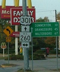
Santee
Santee, South Carolina
Santee is a town in Orangeburg County along the Santee River Valley in central South Carolina of the United States. It has become a resort town of note located centrally north-south along the Atlantic Seaboard of South Carolina...
, at Exit 97 before all three move across Lake Marion
Lake Marion (South Carolina)
Lake Marion is the largest lake in South Carolina, centrally located and with territory within five counties. The lake is referred to as South Carolina's inland sea. It has a shoreline and covers nearly 110,000 acres of rolling farmlands, former marshes, and river valley landscape...
. The U.S. 15
U.S. Route 15
U.S. Route 15 is a -long United States highway, designated along South Carolina, North Carolina, Virginia, Maryland, Pennsylvania, and New York. The route is signed north–south, from U.S. Route 17 Alternate in Walterboro, South Carolina to Interstate 86 and NY 17 in Painted Post, New York.US...
-301 multiplex leaves I-95 at Exit 102, running in close proximity to I-95, but U.S. 15
U.S. Route 15
U.S. Route 15 is a -long United States highway, designated along South Carolina, North Carolina, Virginia, Maryland, Pennsylvania, and New York. The route is signed north–south, from U.S. Route 17 Alternate in Walterboro, South Carolina to Interstate 86 and NY 17 in Painted Post, New York.US...
breaks away at Summerton
Summerton, South Carolina
Summerton is a town in Clarendon County, South Carolina, in the United States. The population was 1,061 at the 2000 census.-Geography:Summerton is at ....
. Other concurrencies include U.S. 521
U.S. Route 521
U.S. Route 521 is an north–south United States highway that runs for from Georgetown, South Carolina to Charlotte, North Carolina.-South Carolina:...
in Manning
Manning, South Carolina
Manning is a city in South Carolina and the county seat of Clarendon County in the Southeastern United States, located in the center of the county, just to the east of Interstate 95 and at the intersection of U.S. 301 and U.S. 521. The population was estimated to be 3,943 as of 2008, down 2% from...
, U.S. 52
U.S. Route 52
U.S. Route 52 is a United States highway that runs across the northern, eastern and southeastern regions of the United States. Contrary to most other even-numbered U.S...
between Effingham and just south of Florence
Florence, South Carolina
-Municipal government and politics:The City of Florence has a council-manager form of government. The mayor and city council are elected every four years, with no term limits...
, U.S. 76
U.S. Route 76
U.S. Route 76 is an east–west United States highway that runs for from Chattanooga, Tennessee to Wrightsville Beach, North Carolina.-Tennessee:...
eastbound from east of Florence until Pee Dee, and finally joins U.S. 501
U.S. Route 501
-North Carolina business loops:-Virginia business loop:-External links:*...
in Latta
Latta, South Carolina
Latta is a town in Dillon County, South Carolina, United States. The population was 1,410 at the 2000 census. This small town also contains one of the many libraries that were started with funds given by Andrew Carnegie, which is located in the center of town....
, where they both approach the South of the Border roadside attraction complex
South of the Border (attraction)
South of the Border is a rest stop and roadside attraction on Interstate 95 and US Highway 301/501 between Dillon, South Carolina and Rowland, North Carolina. It is named "south of the border" being south of the U.S. state of North Carolina...
at the interchange with I-95
Interstate 95 in North Carolina
Interstate 95 is a major Interstate Highway, running along the East Coast of the United States from Florida to Maine. In North Carolina, I-95 runs diagonally across the eastern third of the state, from Rowland in the southwest to Roanoke Rapids in the northeast of the Inner Banks.-Route...
on the north–South Carolina border.
History
U.S. Route 76
U.S. Route 76 is an east–west United States highway that runs for from Chattanooga, Tennessee to Wrightsville Beach, North Carolina.-Tennessee:...
) at Pee Dee northeast through Dillon, South Carolina
Dillon, South Carolina
Dillon, South Carolina, the county seat of Dillon County, was established on December 22, 1888. The name of the city came from James W. Dillon, who was a key component in bringing a railroad through this area of the state, which led to development and formation of the County. Dillon’s population...
, into North Carolina
North Carolina
North Carolina is a state located in the southeastern United States. The state borders South Carolina and Georgia to the south, Tennessee to the west and Virginia to the north. North Carolina contains 100 counties. Its capital is Raleigh, and its largest city is Charlotte...
, and Virginia
Virginia
The Commonwealth of Virginia , is a U.S. state on the Atlantic Coast of the Southern United States. Virginia is nicknamed the "Old Dominion" and sometimes the "Mother of Presidents" after the eight U.S. presidents born there...
, ending at U.S. Route 1
U.S. Route 1
U.S. Route 1 is a major north–south U.S. Highway that serves the East Coast of the United States. It runs 2,377 miles from Fort Kent, Maine at the Canadian border south to Key West, Florida. U.S. 1 generally parallels Interstate 95, though it is significantly farther west between...
in Petersburg, Virginia
Petersburg, Virginia
Petersburg is an independent city in Virginia, United States located on the Appomattox River and south of the state capital city of Richmond. The city's population was 32,420 as of 2010, predominantly of African-American ethnicity...
. This entire route is now paralleled by Interstate 95
Interstate 95
Interstate 95 is the main highway on the East Coast of the United States, running parallel to the Atlantic Ocean from Maine to Florida and serving some of the most populated urban areas in the country, including Boston, Providence, New Haven, New York City, Newark, Philadelphia, Baltimore,...
.
In 1935, US 301 was extended southwest to U.S. Route 15
U.S. Route 15
U.S. Route 15 is a -long United States highway, designated along South Carolina, North Carolina, Virginia, Maryland, Pennsylvania, and New York. The route is signed north–south, from U.S. Route 17 Alternate in Walterboro, South Carolina to Interstate 86 and NY 17 in Painted Post, New York.US...
at Summerton, South Carolina
Summerton, South Carolina
Summerton is a town in Clarendon County, South Carolina, in the United States. The population was 1,061 at the 2000 census.-Geography:Summerton is at ....
. This extension took it west on U.S. Route 76
U.S. Route 76
U.S. Route 76 is an east–west United States highway that runs for from Chattanooga, Tennessee to Wrightsville Beach, North Carolina.-Tennessee:...
(formerly U.S. Route 17
U.S. Route 17
U.S. Route 17 or U.S. Highway 17 is a north–south United States highway. The highway spans the southeastern United States and is close to the Atlantic Coast for much of its length. The highway's southern terminus is at Punta Gorda, Florida, at an intersection with U.S. Route 41...
) to Florence, South Carolina
Florence, South Carolina
-Municipal government and politics:The City of Florence has a council-manager form of government. The mayor and city council are elected every four years, with no term limits...
and south on U.S. Route 52
U.S. Route 52
U.S. Route 52 is a United States highway that runs across the northern, eastern and southeastern regions of the United States. Contrary to most other even-numbered U.S...
(also formerly US 17) to Effingham, South Carolina. There it split to the southwest, running along what had been S.C. Highway 4 via Manning, South Carolina
Manning, South Carolina
Manning is a city in South Carolina and the county seat of Clarendon County in the Southeastern United States, located in the center of the county, just to the east of Interstate 95 and at the intersection of U.S. 301 and U.S. 521. The population was estimated to be 3,943 as of 2008, down 2% from...
to Summerton. This again runs parallel to Interstate 95
Interstate 95 in South Carolina
Interstate 95 is a major Interstate Highway, running along the East Coast of the United States from Florida to Maine. In South Carolina, I-95 runs approximately parallel to the Atlantic Ocean shore although about inland, from Hardeeville in the south to Dillon in the northeast.-Route...
.
In the late 1940s, US 301 was extended again, south all the way towards Tampa, Florida
Tampa, Florida
Tampa is a city in the U.S. state of Florida. It serves as the county seat for Hillsborough County. Tampa is located on the west coast of Florida. The population of Tampa in 2010 was 335,709....
. On the way there from South Carolina it ran along U.S. Route 15
U.S. Route 15
U.S. Route 15 is a -long United States highway, designated along South Carolina, North Carolina, Virginia, Maryland, Pennsylvania, and New York. The route is signed north–south, from U.S. Route 17 Alternate in Walterboro, South Carolina to Interstate 86 and NY 17 in Painted Post, New York.US...
southwest to Santee, South Carolina
Santee, South Carolina
Santee is a town in Orangeburg County along the Santee River Valley in central South Carolina of the United States. It has become a resort town of note located centrally north-south along the Atlantic Seaboard of South Carolina...
and replaced S.C. Highway 4 west to Orangeburg, South Carolina
Orangeburg, South Carolina
Orangeburg, also known as "The Garden City," is the principal city in and the county seat of Orangeburg County, South Carolina, United States. The city is also the fifth oldest city in the state of South Carolina. The city population was 12,765 at the 2000 census, within a Greater Orangeburg...
. From Orangeburg, US 301 ran southwest with U.S. Route 601
U.S. Route 601
Currently, there is one U.S. Route 601 Business loops in North Carolina:* Dobson – It is a route that goes through downtown Dobson, via Main Street.Historically, another business loop had existed in Concord .-See also:...
to Bamberg, South Carolina
Bamberg, South Carolina
Bamberg is a city in and the county seat of Bamberg County, South Carolina, United States. The population was 3,733 at the 2000 census.-Geography:Bamberg is located at ....
, replaced S.C. Highway 33 to Ulmer, South Carolina
Ulmer, South Carolina
Ulmer is a town in Allendale County, South Carolina, United States. The population was 102 at the 2000 census.-Geography:Ulmer is located at ....
, replaced S.C. Highway 508 to Allendale, South Carolina
Allendale, South Carolina
Allendale is a town in Allendale County, South Carolina, United States. The population was 4,052 at the 2000 census. It is the county seat of Allendale County.-Geography:...
, and replaced S.C. Highway 73
South Carolina Highway 73
South Carolina Highway 73 was a highway running along the Atlantic coast in Myrtle Beach, South Carolina.- Route description :...
to the Georgia
Georgia (U.S. state)
Georgia is a state located in the southeastern United States. It was established in 1732, the last of the original Thirteen Colonies. The state is named after King George II of Great Britain. Georgia was the fourth state to ratify the United States Constitution, on January 2, 1788...
state line. When Interstate 95 was built across Lake Marion
Lake Marion (South Carolina)
Lake Marion is the largest lake in South Carolina, centrally located and with territory within five counties. The lake is referred to as South Carolina's inland sea. It has a shoreline and covers nearly 110,000 acres of rolling farmlands, former marshes, and river valley landscape...
in 1968, US 301 and 15 ran parallel to it until they were relocated in a triple concurrency in 1987.