
Hackensack RiverWalk
Encyclopedia
Hackensack RiverWalk a is partially constructed greenway
along the Newark Bay
and Hackensack River
on the west side of the Bergen Neck
peninsula in Hudson County
, New Jersey
. The eight mile walkway, following (where possible) the contour of the water's edge, will run between the southern tip at Bergen Point, where it may connect to the Hudson River Waterfront Walkway
, and Eastern Brackish Marsh in the north. Existing parks and promenades have been incorporated and some new sections have been built, but there are remain large gaps. There is RiverWalk in the city of Hackensack
, sometimes called the Hackensack RiverWalk, but they are not part of the same project nor are they connected. A parallel walkway on the west banks of the river is known as the Meadow Path.
 The walkway will connect the following municipalities and pass through established residential neighborhoods, industrial areas, commercial districts, and nature preserves, some of which are part of the Hackensack Meadowlands. It will pass under sixteen bridges (some no longer used) and cross over eight natural creeks.
The Bergen Point section of the city the Newark Bay waterfront is characterized by maritime, industrial, and retail uses. The center and northern part of the waterfront contains major parks which are not connected to each other, with residential streets from Kennedy Boulevard
ending at the bay. Rutkowksi Park, a wetlands preservation area in the city's northwestern corner (south of the city line) is the city's newest public green space.
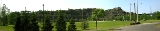
The Secaucus Greenway is a planned to connect the southern and northern porions of town. Completion of this trail will allow public access along the river while providing a continuous pedestrian trail linking Secaucus retail, office, commercial and residential districts. This trail will connect the Laurel Hill
Park and the boat launch at Laurel Hill, Secaucus Junction
, Snipes Park, Secaucus High School, the Mill Ridge Ball Fields
, Mill Creek Point Park, and Mill Creek Marsh. The portions of the Greenway that are completed include trails in the Hudson County#Parks Laurel Hill and a 1.5-mile pedestrian trail through the restored wetland at Mill Creek Marsh, and a .5 mile trail beginning at Mill Creek Point Park traveling south.
The section between Penhorn Creek and the New Jersey Turnpike (south of the former Boonton Line is part of Riverbend Wetlands Preserve. The Anderson Creek Marsh at New Jersey Transit
's Bergen County Line
and Pascack Valley Line
run along the waterfront for a half mile south of Harmon Cove
, a private "gated community", where a path was created when the development was originally built, though the land at its small inlets is privately owned.
Greenway (landscape)
A greenway is a long, narrow piece of land, often used for recreation and pedestrian and bicycle user traffic, and sometimes for streetcar, light rail or retail uses.- Terminology :...
along the Newark Bay
Newark Bay
Newark Bay is a tidal bay at the confluence of the Passaic and Hackensack Rivers in northeastern New Jersey. It is home to the Port Newark-Elizabeth Marine Terminal, the largest container shipping facility in Port of New York and New Jersey, 3rd largest and one of busiest in the United States...
and Hackensack River
Hackensack River
The Hackensack River is a river, approximately 45 miles long, in the U.S. states of New York and New Jersey, emptying into Newark Bay, a back chamber of New York Harbor. The watershed of the river includes part of the suburban area outside New York City just west of the lower Hudson River,...
on the west side of the Bergen Neck
Bergen Neck
Bergen Neck is a name for the peninsula between the Upper New York Bay and the Newark Bay in the Hudson County, New Jersey municipalities of Bayonne and Jersey City...
peninsula in Hudson County
Hudson County, New Jersey
Hudson County is the smallest county in New Jersey and one of the most densely populated in United States. It takes its name from the Hudson River, which creates part of its eastern border. Part of the New York metropolitan area, its county seat and largest city is Jersey City.- Municipalities...
, New Jersey
New Jersey
New Jersey is a state in the Northeastern and Middle Atlantic regions of the United States. , its population was 8,791,894. It is bordered on the north and east by the state of New York, on the southeast and south by the Atlantic Ocean, on the west by Pennsylvania and on the southwest by Delaware...
. The eight mile walkway, following (where possible) the contour of the water's edge, will run between the southern tip at Bergen Point, where it may connect to the Hudson River Waterfront Walkway
Hudson River Waterfront Walkway
The Hudson River Waterfront Walkway, also known as the Hudson River Walkway, is an ongoing and incomplete project located on Kill van Kull and the western shore of Upper New York Bay and the Hudson River, implemented as part of a New Jersey state-mandated master plan to connect the municipalities...
, and Eastern Brackish Marsh in the north. Existing parks and promenades have been incorporated and some new sections have been built, but there are remain large gaps. There is RiverWalk in the city of Hackensack
Hackensack, New Jersey
Hackensack is a city in Bergen County, New Jersey, United States and the county seat of Bergen County. Although informally called Hackensack, it was officially named New Barbadoes Township until 1921. As of the 2010 United States Census, the city population was 43,010....
, sometimes called the Hackensack RiverWalk, but they are not part of the same project nor are they connected. A parallel walkway on the west banks of the river is known as the Meadow Path.
Route
South 40.6518°N 74.1385°W -40.79°N 74.047°W North- BayonneBayonne, New JerseyBayonne is a city in Hudson County, New Jersey, United States. Located in the Gateway Region, Bayonne is a peninsula that is situated between Newark Bay to the west, the Kill van Kull to the south, and New York Bay to the east...
The Bergen Point section of the city the Newark Bay waterfront is characterized by maritime, industrial, and retail uses. The center and northern part of the waterfront contains major parks which are not connected to each other, with residential streets from Kennedy Boulevard
County Route 501 (New Jersey)
County Route 501 is a county highway in New Jersey in two sections spanning Middlesex, Hudson and Bergen Counties. The southern section runs from South Plainfield to Perth Amboy, the northern section runs from Bayonne to Rockleigh, and the two sections are connected by New York State Route 440...
ending at the bay. Rutkowksi Park, a wetlands preservation area in the city's northwestern corner (south of the city line) is the city's newest public green space.
- Jersey CityJersey City, New JerseyJersey City is the seat of Hudson County, New Jersey, United States.Part of the New York metropolitan area, Jersey City lies between the Hudson River and Upper New York Bay across from Lower Manhattan and the Hackensack River and Newark Bay...
- Route 440Route 440 (New Jersey)Route 440 is a state highway in New Jersey, United States. It is composed of two segments, a freeway in Middlesex County linking Interstate 287 and the New Jersey Turnpike in Edison to the Outerbridge Crossing in Perth Amboy and a four-lane divided highway in Hudson County running from the...
south bound right-of-way runs along the bay. Farther inland, the filled-in bed of the former Morris CanalMorris CanalThe Morris Canal was an anthracite-carrying canal that incorporated a series of water-driven inclined planes in its course across northern New Jersey in the United States. It was in use for about a century — from the late 1820s to the 1920s....
in Country VillageCountry Village, Jersey CityCountry Village is an residential enclave in the southwestern corner of the Greenville section of Jersey City, New Jersey that was built as planned community in the early 1960s.-Design and geography:...
may also be considered. - The promenade at Droyer's PointDroyer's PointDroyer's Point is a section of Jersey City, New Jersey at Newark Bay.-Geography:In the southwestern part of the of the city, Droyer's Point is located on the Newark Bay. Its eastern perimeter is New Jersey Route 440. The point is entered from the highway's intersection with Danforth Avenue...
jutting into the bay is completed. - Bayfront is a planned community which will provide access to the shoreline.
- Hackensack RiverfrontHackensack Riverfront-Hackensack Riverfront:The Hackensack Riverfront is an area on the eastern banks of the Hackensack River near its mouth at Newark Bay. It is on the West Side of the city, specifically west of NJ Route 440. It lies north of Droyer's Point and south of Lincoln Park...
area of the Jersey City Public Works and the Hudson Mall have space for a trail behind their facilities. - Lincoln Park WestWest Side, Jersey CityThe West Side of Jersey City is a made of several diverse neighborhoods on either side of West Side Avenue, one of the city's main shopping streets...
contains wetlands preservation area that is part of the largest Hudson County Park - Marion Greenway Park has received funding.
- The northern part the Marion Section contains extensive rail lines and the Hudson Generating StationHudson Generating StationHudson Generating Station in Jersey City, New Jersey is a two-unit, 1,115-megawatt power plant, owned and operated by PSE&G . Unit 1 produces electricity by burning natural gas. Unit 2 runs mainly on coal, but it can also use natural gas...
occupies much waterfrontage. - The Riverbend to Penhorn Creek is a small area containing New Jersey MeadowlandsNew Jersey MeadowlandsNew Jersey Meadowlands, also known as the Hackensack Meadowlands after the primary river flowing through it, is a general name for the large ecosystem of wetlands in northeast New Jersey in the United States. The Meadowlands are known for being the site of large landfills and decades of...
preservation area at the creek.
- SecaucusSecaucus, New JerseySecaucus is a town in Hudson County, New Jersey. As of the 2010 United States Census, the town population was 16,264. Located within the New Jersey Meadowlands, it is the most suburban of the county's municipalities, though large parts of the town are dedicated to light manufacturing, retail, and...
-
The Secaucus Greenway is a planned to connect the southern and northern porions of town. Completion of this trail will allow public access along the river while providing a continuous pedestrian trail linking Secaucus retail, office, commercial and residential districts. This trail will connect the Laurel Hill
Snake Hill
Snake Hill is an igneous rock intrusion jutting some 150 feet up from the floor of the Meadowlands in Secaucus, New Jersey, USA. It was largely obliterated by quarrying in the 1960s that reduced its height by one-quarter and its base area by four fifths...
Park and the boat launch at Laurel Hill, Secaucus Junction
Secaucus Junction
The Frank R. Lautenberg Secaucus Junction Station is a major commuter rail hub in Secaucus, New Jersey...
, Snipes Park, Secaucus High School, the Mill Ridge Ball Fields
Secaucus High School
Secaucus High School is a four-year comprehensive public high school that serves students in ninth through twelfth grade from Secaucus, in Hudson County, New Jersey, United States, operating as part of the Secaucus Board of Education....
, Mill Creek Point Park, and Mill Creek Marsh. The portions of the Greenway that are completed include trails in the Hudson County#Parks Laurel Hill and a 1.5-mile pedestrian trail through the restored wetland at Mill Creek Marsh, and a .5 mile trail beginning at Mill Creek Point Park traveling south.
The section between Penhorn Creek and the New Jersey Turnpike (south of the former Boonton Line is part of Riverbend Wetlands Preserve. The Anderson Creek Marsh at New Jersey Transit
New Jersey Transit
The New Jersey Transit Corporation is a statewide public transportation system serving the United States state of New Jersey, and New York, Orange, and Rockland counties in New York State...
's Bergen County Line
Bergen County Line
The Bergen County Line is a commuter rail line and service owned and operated by New Jersey Transit in the U.S. state of New Jersey. The line loops off the Main Line between the Meadowlands and Glen Rock, with trains continuing in either direction along the Main Line...
and Pascack Valley Line
Pascack Valley Line
The Pascack Valley Line is a commuter rail line operated by the Hoboken Division of New Jersey Transit. The line runs north from Hoboken, New Jersey through Bergen County and into Rockland County, New York, terminating at Spring Valley. Service within New York is operated under contract with...
run along the waterfront for a half mile south of Harmon Cove
Harmon Cove
Harmon Cove is the western section of Secaucus, New Jersey along the Hackensack River, south of New Jersey Route 3. The name is portmanteau taken from Hartz Mountain, a corporation that owns much land in the New Jersey Meadowlands, which originally developed the area as a gated community in the...
, a private "gated community", where a path was created when the development was originally built, though the land at its small inlets is privately owned.
- North BergenNorth Bergen, New JerseyNorth Bergen is a township in Hudson County, New Jersey, United States. As of the United States 2010 Census, the township had a total population of 60,773. Originally founded in 1843, the town was much diminished in territory by a series of secessions. Situated on the Hudson Palisades, it is one...
- A planned trail from Harmon Meadow PlazaHarmon Meadow PlazaHarmon Meadow Plaza is a shopping complex in the Meadowlands of Secaucus, New Jersey, approximately six miles from New York City. It is owned by Hartz Mountain Industries, whose corporate offices are located in the Plaza...
through Eastern Brackish Marsh parallel to West Side Avenue will end at 71st Street Park.
Points of interest
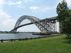
- Bayonne BridgeBayonne BridgeThe Bayonne Bridge is the fourth longest steel arch bridge in the world, and was the longest in the world at the time of its completion. It connects Bayonne, New Jersey with Staten Island, New York, spanning the Kill Van Kull. Despite popular belief, it is not a national landmark.The bridge was...
- Bergen Point
- Newark BayNewark BayNewark Bay is a tidal bay at the confluence of the Passaic and Hackensack Rivers in northeastern New Jersey. It is home to the Port Newark-Elizabeth Marine Terminal, the largest container shipping facility in Port of New York and New Jersey, 3rd largest and one of busiest in the United States...
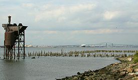
- Shooters IslandShooters IslandShooters Island is a uninhabited island at the southern end of Newark Bay, along the north shore of Staten Island. The boundary between the states of New York and New Jersey runs through the island, with a small portion on the north end of the island belonging to the cities of Bayonne and...
, an off shore bird sanctuary in the Kill van KullKill Van KullThe Kill Van Kull is a tidal strait between Staten Island, New York and Bayonne, New Jersey in the United States. Approximately long and wide, it connects Newark Bay with Upper New York Bay. The Robbins Reef Light marks the eastern end of the Kill, Bergen Point its western end...
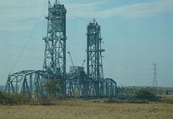
which the New York/New Jersey state line runs through - Arthur Kill Vertical Lift BridgeArthur Kill Vertical Lift BridgeThe Arthur Kill Vertical Lift Railroad Bridge is a railroad-only, vertical lift bridge connecting Elizabethport, New Jersey and the Howland Hook Marine Terminal on Staten Island. The bridge was built by the Baltimore and Ohio Railroad in 1959 to replace an older swing span...
, to the southwest crossing the Arthur Kill - Central Railroad of New JerseyCentral Railroad of New JerseyThe Central Railroad of New Jersey , commonly known as the Jersey Central Lines or CNJ, was a Class I railroad with origins in the 1830s, lasting until 1976 when it was absorbed into Conrail with the other bankrupt railroads of the Northeastern United States...
caissonsCaisson (engineering)In geotechnical engineering, a caisson is a retaining, watertight structure used, for example, to work on the foundations of a bridge pier, for the construction of a concrete dam, or for the repair of ships. These are constructed such that the water can be pumped out, keeping the working... - Port Newark-Elizabeth Marine TerminalPort Newark-Elizabeth Marine TerminalPort Newark-Elizabeth Marine Terminal is a major component of the Port of New York and New Jersey. Located on the Newark Bay it serves as the principal container ship facility for goods entering and leaving New York-Newark metropolitan area, and the northeastern quadrant of North America...
and Newark International Airport, across the bay - Bayonne City Park
- Veterans Memorial Park
- Bayonne High SchoolBayonne High SchoolBayonne High School is a four-year comprehensive public high school located in Bayonne, Hudson County, New Jersey, operated by the Bayonne Board of Education....
- Hudson County Park, named for Stephen R. GreggStephen R. GreggStephen Raymond Gregg, Sr., was a United States Army soldier and a recipient of the United States military's highest decoration—the Medal of Honor—for his actions in World War II.-Biography:...
- Rutkowski Park, a wetlands preservation area
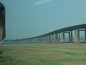
- Newark Bay BridgeNewark Bay BridgeThe Newark Bay Bridge is a steel through arch bridge that is continuous across three spans. It crosses Newark Bay and connects the cities of Newark and Bayonne in New Jersey...
, part of New Jersey TurnpikeNew Jersey TurnpikeThe New Jersey Turnpike is a toll road in New Jersey, maintained by the New Jersey Turnpike Authority. According to the International Bridge, Tunnel and Turnpike Association, the Turnpike is the nation's sixth-busiest toll road and is among one of the most heavily traveled highways in the United...
Extension I-78 - Lehigh Valley Railroad BridgeLehigh Valley Railroad BridgeThe Lehigh Valley Railroad Bridge is a vertical lift bridge spanning the Newark Bay in northeastern New Jersey. It is used by CSX Transportation travelling through the North Jersey Shared Assets Area of the United States rail network along the National Docks Secondary line. The bridge is just north...
- Route 440
- Morris CanalMorris CanalThe Morris Canal was an anthracite-carrying canal that incorporated a series of water-driven inclined planes in its course across northern New Jersey in the United States. It was in use for about a century — from the late 1820s to the 1920s....
section further inland - New Jersey City UniversityNew Jersey City UniversityNew Jersey City University is a public university in Jersey City, New Jersey, USA. It is a member of the New Jersey Association of State Colleges and Universities....
Athletic Complex - Droyer's PointDroyer's PointDroyer's Point is a section of Jersey City, New Jersey at Newark Bay.-Geography:In the southwestern part of the of the city, Droyer's Point is located on the Newark Bay. Its eastern perimeter is New Jersey Route 440. The point is entered from the highway's intersection with Danforth Avenue...
- Kearny Point, across the river's mouth
- Bayfront
- New York and Newark Railroad Bridge caissonsCaisson (engineering)In geotechnical engineering, a caisson is a retaining, watertight structure used, for example, to work on the foundations of a bridge pier, for the construction of a concrete dam, or for the repair of ships. These are constructed such that the water can be pumped out, keeping the working...
- Jersey City Public Works facility
- Hudson Mall & Fourhundred Forty Shopping Center
- U.S. Route 1/9 Truck, originally part of the transcontinental Lincoln HighwayLincoln HighwayThe Lincoln Highway was the first road across the United States of America.Conceived and promoted by entrepreneur Carl G. Fisher, the Lincoln Highway spanned coast-to-coast from Times Square in New York City to Lincoln Park in San Francisco, originally through 13 states: New York, New Jersey,...
- Lincoln Park WestLincoln Park (Jersey City)Lincoln Park is an urban park in Jersey City, New Jersey with an area of . Opened in 1905, it was originally known as West Side Park. The park was designed by Daniel W. Langton and Charles N. Lowrie, both founding members of the American Society of Landscape Architects.The park consists of two...
- Hudson County Police Headquarters
- Pulaski SkywayPulaski SkywayThe General Pulaski Skyway is a four-lane freeway composed of connected bridges in the northeastern part of the U.S. state of New Jersey, carrying the designation of U.S. Route 1/9 for most of its length. The landmark structure has a total length of with the longest bridge spanning...
, considered to be America's first super highwaySuper HighwayThe M9, also known as "Super Highway", is a 138-km long motorway connecting the cities of Hyderabad and Karachi in Sindh province of Pakistan. It is part of Pakistan's Motorway Network.- Route :... - Marion Greenway
- PATH Lift Bridge)
- Harsimus Branch LiftPassaic and Harsimus LineConrail's Passaic and Harsimus Line serves freight in northeastern New Jersey, as an alternate to the mainly passenger Northeast Corridor. It takes trains from the Northeast Corridor and Lehigh Line near Newark Liberty International Airport northeast and east into Jersey City, New Jersey, serving...
, used for rail freight - Wittpenn BridgeWittpenn BridgeThe Wittpenn Bridge is a vertical lift bridge that carries New Jersey Route 7 over the Hackensack River connecting Kearny and Jersey City, New Jersey. It is named after H. Otto Wittpenn, a former mayor of Jersey City. The bridge comprises four -wide lanes, extending and standing above mean high...
, for NJ Route 7 - Lower Hack LiftLower Hack LiftThe Lower Hack Lift is a lift bridge carrying the New Jersey Transit Morristown Line across the Hackensack River at mile 3.4, Jersey City, New Jersey....
, bridge used by NJ Transit Hoboken and Newark Division trains - Hudson Generating StationHudson Generating StationHudson Generating Station in Jersey City, New Jersey is a two-unit, 1,115-megawatt power plant, owned and operated by PSE&G . Unit 1 produces electricity by burning natural gas. Unit 2 runs mainly on coal, but it can also use natural gas...
, formerly Public Service Railroad Powerhouse - Croxton YardsCroxton, Jersey CityCroxton is a section of Jersey City, New Jersey roughly bounded by Secaucus at Penhorn Creek , The Riverbend of the Hackensack River and the Hudson Generating Station and the Marion Section to the south and Truck 1-9 and Western Slope to the east...
- Penhorn Creek
- Riverbend Wetlands Preserve
- Secaucus Transfer StationSecaucus JunctionThe Frank R. Lautenberg Secaucus Junction Station is a major commuter rail hub in Secaucus, New Jersey...
, main commuter hub, further inland - Portal BridgePortal BridgeThe Portal Bridge is a rail bridge over the Hackensack River just west of Secaucus Junction in northeastern New Jersey, USA. The two-track, moveable swing-span between the towns of Kearny and Secaucus is owned and operated by Amtrak...
, part of the Northeast CorridorNortheast CorridorThe Northeast Corridor is a fully electrified railway line owned primarily by Amtrak serving the Northeast megalopolis of the United States from Boston in the north, via New York to Washington, D.C. in the south, with branches serving other cities...
used by Amtrak and NJ Transit - New Jersey TurnpikeNew Jersey TurnpikeThe New Jersey Turnpike is a toll road in New Jersey, maintained by the New Jersey Turnpike Authority. According to the International Bridge, Tunnel and Turnpike Association, the Turnpike is the nation's sixth-busiest toll road and is among one of the most heavily traveled highways in the United...
Eastern Spur Bridge - Snake HillSnake HillSnake Hill is an igneous rock intrusion jutting some 150 feet up from the floor of the Meadowlands in Secaucus, New Jersey, USA. It was largely obliterated by quarrying in the 1960s that reduced its height by one-quarter and its base area by four fifths...
, also known as Fraternity Rock, former site of insane asylum where the mineral Petersite was first discovered in 1981 - DB DrawDB DrawDB Draw is a railroad swing bridge crossing the Hackensack River between Secaucus and Kearny, in New Jersey, United States. It was built in 1899 by the New York, Lake Erie and Western Railroad...
, de-commissioned bridge on NJ Transit Boonton Line abandoned in 2002 - Saw Mill Creek Wildlife Preservation Area/Kearny MarshKearny, New JerseyKearny is a town in Hudson County, New Jersey, United States. It was named after Civil War general Philip Kearny. As of the United States 2010 Census, the town population was 40,684. The town is a suburb of the nearby city of Newark....
across the river - Laurel HillLaurel HillLaurel Hill may refer to the following:In Australia*Laurel Hill, New South Wales, a town in the Riverina regionIn Ireland*Laurel Hill Coláiste, a school in Limerick, IrelandIn the United States*Laurel Hill, Florida, a city in Okaloosa County...
Park - DeKorte Park, across the river in Lyndhurst, home to the Meadowlands Environment CenterMeadowlands Environment CenterThe Meadowlands Environment Center is an educational facility in the New Jersey Meadowlands in Lyndhurst, New Jersey. It is currently operated by Ramapo College of New Jersey, under the auspices of the New Jersey Meadowlands Commission .The center is at the Richard W...
- Upper Hack LiftUpper Hack LiftUpper Hack Lift is a lift bridge carrying the New Jersey Transit Main Line across the Hackensack River at mile 6.9 between Secaucus, New Jersey and Lyndhurst....
, for NJ Transit's Main LineMain Line (NJ Transit)The Main Line is a rail line owned and operated by New Jersey Transit running from Suffern, New York to Hoboken, New Jersey. It runs daily commuter service and was once the north-south main line of the Erie Lackawanna Railroad...
and Metro-North's Port Jervis Line - Anderson Marsh
- HX DrawHX DrawThe HX Draw is a bascule bridge carrying the New Jersey Transit Bergen County Line and Pascack Valley Line across the Hackensack River between Secaucus, New Jersey and East Rutherford...
for NJ Transit's Bergen County LineBergen County LineThe Bergen County Line is a commuter rail line and service owned and operated by New Jersey Transit in the U.S. state of New Jersey. The line loops off the Main Line between the Meadowlands and Glen Rock, with trains continuing in either direction along the Main Line...
and Pascack Valley LinePascack Valley LineThe Pascack Valley Line is a commuter rail line operated by the Hoboken Division of New Jersey Transit. The line runs north from Hoboken, New Jersey through Bergen County and into Rockland County, New York, terminating at Spring Valley. Service within New York is operated under contract with... - Harmon CoveHarmon CoveHarmon Cove is the western section of Secaucus, New Jersey along the Hackensack River, south of New Jersey Route 3. The name is portmanteau taken from Hartz Mountain, a corporation that owns much land in the New Jersey Meadowlands, which originally developed the area as a gated community in the...
- Meadowlands Hospital
- Route 3 twin span bridge
- North End Trolley ParkNorth End, SecaucusAs its name suggests, the North End in Secaucus, New Jersey, is the section of town north of New Jersey Route 3 and the Secaucus Plaza Central Business District, to which it is connected by Paterson Plank Road...
- Meadowlands Sports ComplexMeadowlands Sports ComplexThe MetLife Sports Complex is a sports and entertainment facility located in East Rutherford, Bergen County, New Jersey, United States, owned and operated by the New Jersey Sports and Exposition Authority...
, across the water - Snipes Park
- Mill Creek Marsh
- Harmon Meadow PlazaHarmon Meadow PlazaHarmon Meadow Plaza is a shopping complex in the Meadowlands of Secaucus, New Jersey, approximately six miles from New York City. It is owned by Hartz Mountain Industries, whose corporate offices are located in the Plaza...
- Paunpeck Creek
- Eastern Brackish Marsh
See also
- Hackensack RiverfrontHackensack Riverfront-Hackensack Riverfront:The Hackensack Riverfront is an area on the eastern banks of the Hackensack River near its mouth at Newark Bay. It is on the West Side of the city, specifically west of NJ Route 440. It lies north of Droyer's Point and south of Lincoln Park...
- Hudson Parks
- Hudson River Waterfront WalkwayHudson River Waterfront WalkwayThe Hudson River Waterfront Walkway, also known as the Hudson River Walkway, is an ongoing and incomplete project located on Kill van Kull and the western shore of Upper New York Bay and the Hudson River, implemented as part of a New Jersey state-mandated master plan to connect the municipalities...
- List of crossings of the Hackensack River
External links
- http://www.hudsonreporter.com/view/full_story/6220380/article-Advancing-long-bike-hike-path-through-Secaucus-NJ-Transit-to-hold-public-hearing-in-town-
- Portal Bridge proposal
- Marina access to Hackensack River
- NJMC: Hackensack river Guide
- Hackensack River bridges
- Things To Do:Jersey City
- river Barge Park