

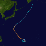
Typhoon Pamela (1976)
Encyclopedia
Typhoon Pamela was a powerful typhoon that struck the U.S. territory of Guam
in May 1976, causing about $500 million in damage (USD
). The sixth named storm
and third typhoon of the 1976 Pacific typhoon season
, Pamela developed on May 14 from a trough
near the Federated States of Micronesia
. It executed a counterclockwise loop and slowly intensified, bringing heavy rains to the islands in the region. Ten people died on Chuuk
due to a landslide. After beginning a steady northwest motion toward Guam, Pamela attained its peak winds of 240 km/h (150 mph).
On May 21, the large eye
of the typhoon crossed Guam, producing typhoon-force winds (greater than 118 km/h or 73 mph) for a period of 18 hours. An estimated 80% of the buildings on the island were damaged to some degree, including 3,300 houses that were destroyed. Pamela's slow motion produced 856 mm (33.7 in) of rainfall, making May 1976 the wettest on record in Guam. Despite the high damage, there was only one death due to well-executed warnings. After affecting the island, the typhoon weakened and turned northeastward, passing near Iwo Jima
before becoming an extratropical cyclone
.
 The origins of Typhoon Pamela were from a tropical disturbance that persisted in the eastern end of the equator
ial trough
on May 13. At the time, it was located about 425 km (265 mi) north of Chuuk
in the Federated States of Micronesia
. The disturbance was initially difficult to locate as it tracked generally to the south and southwest, a motion caused by a southward-moving tropical upper tropospheric trough
. On May 14, the Japan Meteorological Agency
(JMA) indicated that the system developed into a tropical cyclone. That same day, the Joint Typhoon Warning Center
(JTWC) followed suit and classified it as Tropical Depression 06W. The next day, data from the Hurricane Hunters
indicated that the depression intensified into Tropical Storm Pamela. It was able to intensify after the trough receded northward, developing outflow
. The storm turned to the south and east, gradually executing a counterclockwise loop through the FSM. This was due to a building ridge
between Pamela and Typhoon Olga to its west. On May 16, observations from Satawan
in the Caroline Islands
indicated that Pamela attained typhoon status, which is a tropical cyclone
with maximum sustained wind
s of at least 118 km/h (74 mph). This was confirmed the next day by the Hurricane Hunters.
Upon attaining typhoon status, Pamela was a small tropical cyclone with a central dense overcast
spanning 280 km (175 mi) in diameter. After completing its counterclockwise loop, the typhoon began a slow motion to the northwest, once the ridge to its west diminished. On May 18, it passed within 95 km (60 mi) of Chuuk, and around that time Pamela developed a circular eye
about 18 km (12 mi) in diameter. The typhoon steadily intensified as it began a more steady northwest movement due to a ridge to its east, and on May 19 Pamela attained peak winds of 240 km/h (150 mph) about 485 km (300 mi) southeast of Guam
. At that time, it had gust
s to 295 km/h (185 mph).
Typhoon Pamela maintained peak intensity for about 18 hours, during which the Hurricane Hunters reported a atmospheric pressure
of 921 millibars (27.2 inHg); the aircraft also reported concentric eyewalls
. The JMA estimated the minimum pressure was slightly lower at 920 millibars (27.2 inHg). A trough passing to its north caused the typhoon to turn more to the north-northwest. Around 0400 UTC
on May 21, the eyewall of Pamela struck southeastern Guam with winds of about 220 km/h (140 mph). Over a three hour period, the 37 km (23 mi) wide eye crossed the island. After leaving the island, Pamela continued steadily northwestward for two days while maintaining its intensity. On May 23, it turned to the north and northeast due to a break in the subtropical ridge
. The typhoon passed 28 km (17 mi) east of Iwo Jima
with winds of 140 km/h (85 mph). As Pamela accelerated over cooler waters and into an area of higher wind shear
, it rapidly weakened and was downgraded to a tropical storm on May 25. The next day, the storm became extratropical
,. which lasted until June 1 before dissipating over the Bering Sea
.
and Air Force
evacuated assets. Before the typhoon's arrival, officials advised residents to store water prior to the storm's arrival. About 2,100 people in vulnerable wooden homes were evacuated to storm shelters set up in schools and public offices.
From May 17 to 18, at the Weather Service on Chuuk, Pamela dumped 14.59 in (370.6 mm) of rain. This was due to the typhoon's slow movement. The rains resulted in mudslides that killed 10 people, many of whom in a single burried house; several people were also injured. Across the island, the typhoon also left heavy crop damage. Winds reached 91 km/h (56 km/h).
Later, the typhoon produced tropical-storm force gusts and 10 in (254 mm) of rain on Saipan
. Impact there was minor.
that caused additional damage. The typhoon dropped a total of 856 mm (33.7 in) of rainfall, including 690 mm (27 in) in a 24 hour period, on the island. This contributed to May 1976 being Guam's wettest month on record.
In Apra Harbor
, ten ships or tugs were sunk, as were numerous smaller vessels. One of the ships that survived in the harbor was the cutter
Basswood of the Coast Guard
, which recorded a wind gust of 220 km/h (140 mph). Pamela's damage prevented regular flights in and out of the island.
The typhoon left extensive damage to military and civilian propterties on the island, estimated around $500 million (1976 USD). Trees were also uprooted throughout the island. Although Pamela was not as strong as Typhoon Karen in 1962
, it proved more costly due to its slow movement. Concrete buildings largely survived the storm, but power lines and wooden structures were devastated. The typhoon cut off all public utilities on the island as well as Guam's two radio stations. The American Red Cross
estimated that Pamela destroyed 3,300 houses and significantly damaged another 3,200. Government officials preliminarily estimated that 80% of the buildings were damaged to some degree, of which half were destroyed. Overall, 14,000 families sustained damage during the storm. About 300 people on the island were injured, and although the Red Cross reported three fatalities, the JTWC reported only one death in Guam in the year-end report. The low death total was attributed to timely warnings and forecasts.
in Japan assumed forecasting and warning responsibilities for five days starting on May 20. The cleanup and recovery took months, assisted by military personnel. During the aftermath, food shortages resulted in long lines for aid at Anderson Air Force Base. Due to Pamela as well as the occurrence of other disasters in 1976, the American Red Cross
went into debt, after providing about $10 million in assistance to 16,000 families. The agency set up 29 shelters for 2,600 people.
On May 22, a day after the typhoon struck the island, U.S. President
Gerald Ford
declared Guam a major disaster area. In September 1976, the United States Senate
passed a bill that included aid for the storm victims. Ultimately, the U.S. government provided $200 million in aid and reconstruction funding in the two years following the typhoon's passage. This included about $80 million to repair Guam's military facilities, which took several years to complete. Following the typhoon's passage and through the 1980's, the island's wooden homes underwent the process of being replaced by safer concrete homes.
Guam
Guam is an organized, unincorporated territory of the United States located in the western Pacific Ocean. It is one of five U.S. territories with an established civilian government. Guam is listed as one of 16 Non-Self-Governing Territories by the Special Committee on Decolonization of the United...
in May 1976, causing about $500 million in damage (USD
United States dollar
The United States dollar , also referred to as the American dollar, is the official currency of the United States of America. It is divided into 100 smaller units called cents or pennies....
). The sixth named storm
Tropical cyclone naming
Tropical cyclones have officially been named since 1945 and are named for a variety of reasons, which include to facilitate communications between forecasters and the public when forecasts, watches, and warnings are issued. Names also reduce confusion about what storm is being described, as more...
and third typhoon of the 1976 Pacific typhoon season
1976 Pacific typhoon season
The 1976 Pacific typhoon season has no official bounds; it ran year-round in 1976, but most tropical cyclones tend to form in the northwestern Pacific Ocean between June and December...
, Pamela developed on May 14 from a trough
Trough (meteorology)
A trough is an elongated region of relatively low atmospheric pressure, often associated with fronts.Unlike fronts, there is not a universal symbol for a trough on a weather chart. The weather charts in some countries or regions mark troughs by a line. In the United States, a trough may be marked...
near the Federated States of Micronesia
Federated States of Micronesia
The Federated States of Micronesia or FSM is an independent, sovereign island nation, made up of four states from west to east: Yap, Chuuk, Pohnpei and Kosrae. It comprises approximately 607 islands with c...
. It executed a counterclockwise loop and slowly intensified, bringing heavy rains to the islands in the region. Ten people died on Chuuk
Chuuk
Chuuk — formerly Truk, Ruk, Hogoleu, Torres, Ugulat, and Lugulus — is an island group in the south western part of the Pacific Ocean. It comprises one of the four states of the Federated States of Micronesia , along with Kosrae, Pohnpei, and Yap. Chuuk is the most populous of the FSM's...
due to a landslide. After beginning a steady northwest motion toward Guam, Pamela attained its peak winds of 240 km/h (150 mph).
On May 21, the large eye
Eye (cyclone)
The eye is a region of mostly calm weather found at the center of strong tropical cyclones. The eye of a storm is a roughly circular area and typically 30–65 km in diameter. It is surrounded by the eyewall, a ring of towering thunderstorms where the second most severe weather of a cyclone...
of the typhoon crossed Guam, producing typhoon-force winds (greater than 118 km/h or 73 mph) for a period of 18 hours. An estimated 80% of the buildings on the island were damaged to some degree, including 3,300 houses that were destroyed. Pamela's slow motion produced 856 mm (33.7 in) of rainfall, making May 1976 the wettest on record in Guam. Despite the high damage, there was only one death due to well-executed warnings. After affecting the island, the typhoon weakened and turned northeastward, passing near Iwo Jima
Iwo Jima
Iwo Jima, officially , is an island of the Japanese Volcano Islands chain, which lie south of the Ogasawara Islands and together with them form the Ogasawara Archipelago. The island is located south of mainland Tokyo and administered as part of Ogasawara, one of eight villages of Tokyo...
before becoming an extratropical cyclone
Extratropical cyclone
Extratropical cyclones, sometimes called mid-latitude cyclones or wave cyclones, are a group of cyclones defined as synoptic scale low pressure weather systems that occur in the middle latitudes of the Earth having neither tropical nor polar characteristics, and are connected with fronts and...
.
Meteorological history
Equator
An equator is the intersection of a sphere's surface with the plane perpendicular to the sphere's axis of rotation and containing the sphere's center of mass....
ial trough
Trough (meteorology)
A trough is an elongated region of relatively low atmospheric pressure, often associated with fronts.Unlike fronts, there is not a universal symbol for a trough on a weather chart. The weather charts in some countries or regions mark troughs by a line. In the United States, a trough may be marked...
on May 13. At the time, it was located about 425 km (265 mi) north of Chuuk
Chuuk
Chuuk — formerly Truk, Ruk, Hogoleu, Torres, Ugulat, and Lugulus — is an island group in the south western part of the Pacific Ocean. It comprises one of the four states of the Federated States of Micronesia , along with Kosrae, Pohnpei, and Yap. Chuuk is the most populous of the FSM's...
in the Federated States of Micronesia
Federated States of Micronesia
The Federated States of Micronesia or FSM is an independent, sovereign island nation, made up of four states from west to east: Yap, Chuuk, Pohnpei and Kosrae. It comprises approximately 607 islands with c...
. The disturbance was initially difficult to locate as it tracked generally to the south and southwest, a motion caused by a southward-moving tropical upper tropospheric trough
Tropical Upper Tropospheric Trough
A tropical upper tropospheric trough , also known as the mid-oceanic trough, is a trough situated in upper-level tropics. Its formation is usually caused by the intrusion of energy and wind from the mid-latitudes into the tropics. It can also develop from the inverted trough adjacent to an upper...
. On May 14, the Japan Meteorological Agency
Japan Meteorological Agency
The or JMA, is the Japanese government's weather service. Charged with gathering and reporting weather data and forecasts in Japan, it is a semi-autonomous part of the Ministry of Land, Infrastructure and Transport...
(JMA) indicated that the system developed into a tropical cyclone. That same day, the Joint Typhoon Warning Center
Joint Typhoon Warning Center
The Joint Typhoon Warning Center is a joint United States Navy – United States Air Force task force located at the Naval Maritime Forecast Center in Pearl Harbor, Hawaii...
(JTWC) followed suit and classified it as Tropical Depression 06W. The next day, data from the Hurricane Hunters
Hurricane Hunters
The Hurricane Hunters are aircraft that fly into tropical cyclones in the North Atlantic Ocean and Northeastern Pacific Ocean for the specific purpose of directly measuring weather data in and around those storms. In the United States, the Air Force, Navy, and NOAA units have all participated in...
indicated that the depression intensified into Tropical Storm Pamela. It was able to intensify after the trough receded northward, developing outflow
Outflow (meteorology)
Outflow, in meteorology, is air that flows outwards from a storm system. It is associated with ridging, or anticyclonic flow. In the low levels of the troposphere, outflow radiates from thunderstorms in the form of a wedge of rain-cooled air, which is visible as a thin rope-like cloud on weather...
. The storm turned to the south and east, gradually executing a counterclockwise loop through the FSM. This was due to a building ridge
Ridge (meteorology)
A ridge is an elongated region of relatively high atmospheric pressure, the opposite of a trough....
between Pamela and Typhoon Olga to its west. On May 16, observations from Satawan
Satawan
Satawan Atoll is part of the Mortlock Islands in the Caroline Islands, administratively part of Chuuk State in the Federated States of Micronesia. Captain James Mortlock discovered two sets of islands on 19 and 27 November 1795. Confusingly, both were later called Mortlock Islands...
in the Caroline Islands
Caroline Islands
The Caroline Islands are a widely scattered archipelago of tiny islands in the western Pacific Ocean, to the north of New Guinea. Politically they are divided between the Federated States of Micronesia in the eastern part of the group, and Palau at the extreme western end...
indicated that Pamela attained typhoon status, which is a tropical cyclone
Tropical cyclone
A tropical cyclone is a storm system characterized by a large low-pressure center and numerous thunderstorms that produce strong winds and heavy rain. Tropical cyclones strengthen when water evaporated from the ocean is released as the saturated air rises, resulting in condensation of water vapor...
with maximum sustained wind
Maximum sustained wind
The maximum sustained winds associated with a tropical cyclone are a common indicator of the intensity of the storm. Within a mature tropical cyclone, they are found within the eyewall at a distance defined as the radius of maximum wind, or RMW. Unlike gusts, the value of these winds are...
s of at least 118 km/h (74 mph). This was confirmed the next day by the Hurricane Hunters.
Upon attaining typhoon status, Pamela was a small tropical cyclone with a central dense overcast
Eye (cyclone)
The eye is a region of mostly calm weather found at the center of strong tropical cyclones. The eye of a storm is a roughly circular area and typically 30–65 km in diameter. It is surrounded by the eyewall, a ring of towering thunderstorms where the second most severe weather of a cyclone...
spanning 280 km (175 mi) in diameter. After completing its counterclockwise loop, the typhoon began a slow motion to the northwest, once the ridge to its west diminished. On May 18, it passed within 95 km (60 mi) of Chuuk, and around that time Pamela developed a circular eye
Eye (cyclone)
The eye is a region of mostly calm weather found at the center of strong tropical cyclones. The eye of a storm is a roughly circular area and typically 30–65 km in diameter. It is surrounded by the eyewall, a ring of towering thunderstorms where the second most severe weather of a cyclone...
about 18 km (12 mi) in diameter. The typhoon steadily intensified as it began a more steady northwest movement due to a ridge to its east, and on May 19 Pamela attained peak winds of 240 km/h (150 mph) about 485 km (300 mi) southeast of Guam
Guam
Guam is an organized, unincorporated territory of the United States located in the western Pacific Ocean. It is one of five U.S. territories with an established civilian government. Guam is listed as one of 16 Non-Self-Governing Territories by the Special Committee on Decolonization of the United...
. At that time, it had gust
Gust
is a Japanese developer and publisher of game software titles, known for their Atelier and Ar tonelico series.-Company:Gust Co. Ltd. was founded in 1993 in Nagano, Japan, as the first game software house in Nagano Prefecture. The company began by creating dôjinshi games for personal computers. Its...
s to 295 km/h (185 mph).
Typhoon Pamela maintained peak intensity for about 18 hours, during which the Hurricane Hunters reported a atmospheric pressure
Atmospheric pressure
Atmospheric pressure is the force per unit area exerted into a surface by the weight of air above that surface in the atmosphere of Earth . In most circumstances atmospheric pressure is closely approximated by the hydrostatic pressure caused by the weight of air above the measurement point...
of 921 millibars (27.2 inHg); the aircraft also reported concentric eyewalls
Eyewall replacement cycle
Eyewall replacement cycles, also called concentric eyewall cycles, naturally occur in intense tropical cyclones, generally with winds greater than 185 km/h , or major hurricanes...
. The JMA estimated the minimum pressure was slightly lower at 920 millibars (27.2 inHg). A trough passing to its north caused the typhoon to turn more to the north-northwest. Around 0400 UTC
Coordinated Universal Time
Coordinated Universal Time is the primary time standard by which the world regulates clocks and time. It is one of several closely related successors to Greenwich Mean Time. Computer servers, online services and other entities that rely on having a universally accepted time use UTC for that purpose...
on May 21, the eyewall of Pamela struck southeastern Guam with winds of about 220 km/h (140 mph). Over a three hour period, the 37 km (23 mi) wide eye crossed the island. After leaving the island, Pamela continued steadily northwestward for two days while maintaining its intensity. On May 23, it turned to the north and northeast due to a break in the subtropical ridge
Subtropical ridge
The subtropical ridge is a significant belt of high pressure situated around the latitudes of 30°N in the Northern Hemisphere and 30°S in the Southern Hemisphere. It is characterized by mostly calm winds, which acts to reduce air quality under its axis by causing fog overnight, and haze during...
. The typhoon passed 28 km (17 mi) east of Iwo Jima
Iwo Jima
Iwo Jima, officially , is an island of the Japanese Volcano Islands chain, which lie south of the Ogasawara Islands and together with them form the Ogasawara Archipelago. The island is located south of mainland Tokyo and administered as part of Ogasawara, one of eight villages of Tokyo...
with winds of 140 km/h (85 mph). As Pamela accelerated over cooler waters and into an area of higher wind shear
Wind shear
Wind shear, sometimes referred to as windshear or wind gradient, is a difference in wind speed and direction over a relatively short distance in the atmosphere...
, it rapidly weakened and was downgraded to a tropical storm on May 25. The next day, the storm became extratropical
Extratropical cyclone
Extratropical cyclones, sometimes called mid-latitude cyclones or wave cyclones, are a group of cyclones defined as synoptic scale low pressure weather systems that occur in the middle latitudes of the Earth having neither tropical nor polar characteristics, and are connected with fronts and...
,. which lasted until June 1 before dissipating over the Bering Sea
Bering Sea
The Bering Sea is a marginal sea of the Pacific Ocean. It comprises a deep water basin, which then rises through a narrow slope into the shallower water above the continental shelves....
.
Preparations and Impact
Pamela first presented a threat to Guam on May 16 when it first attained typhoon status. All subsequent forecasts anticipated the typhoon would pass within 185 km (115 mi). In response to Pamela's approach, Guam was placed under Typhoon Condition of Readiness III (TCCOR 3) on May 18. This was upgrade to TCCOR II on later that day, and TCCOR I the next day. The NavyUnited States Navy
The United States Navy is the naval warfare service branch of the United States Armed Forces and one of the seven uniformed services of the United States. The U.S. Navy is the largest in the world; its battle fleet tonnage is greater than that of the next 13 largest navies combined. The U.S...
and Air Force
United States Air Force
The United States Air Force is the aerial warfare service branch of the United States Armed Forces and one of the American uniformed services. Initially part of the United States Army, the USAF was formed as a separate branch of the military on September 18, 1947 under the National Security Act of...
evacuated assets. Before the typhoon's arrival, officials advised residents to store water prior to the storm's arrival. About 2,100 people in vulnerable wooden homes were evacuated to storm shelters set up in schools and public offices.
Trust Territory of the Pacific Islands
While passing near Satawan in the Caroline Islands, Pamela produced winds of over 102 km/h (64 mph), which left damage but no deaths.From May 17 to 18, at the Weather Service on Chuuk, Pamela dumped 14.59 in (370.6 mm) of rain. This was due to the typhoon's slow movement. The rains resulted in mudslides that killed 10 people, many of whom in a single burried house; several people were also injured. Across the island, the typhoon also left heavy crop damage. Winds reached 91 km/h (56 km/h).
Later, the typhoon produced tropical-storm force gusts and 10 in (254 mm) of rain on Saipan
Saipan
Saipan is the largest island of the United States Commonwealth of the Northern Mariana Islands , a chain of 15 tropical islands belonging to the Marianas archipelago in the western Pacific Ocean with a total area of . The 2000 census population was 62,392...
. Impact there was minor.
Guam
While slowly crossing Guam, Pamela produced winds of over 185 km/h (115 mph) across the entire island over a six hour period, causing widespread heavy damage. Typhoon-force winds were reported for 18 hours, and tropical storm force winds were reported for 30 hours. As the eye was crossing the island, the winds rapidly vascillated between gusts of 150 km/h (90 mph) to calmness in the span of a few minutes; this created a large pressure gradientPressure gradient
In atmospheric sciences , the pressure gradient is a physical quantity that describes in which direction and at what rate the pressure changes the most rapidly around a particular location. The pressure gradient is a dimensional quantity expressed in units of pressure per unit length...
that caused additional damage. The typhoon dropped a total of 856 mm (33.7 in) of rainfall, including 690 mm (27 in) in a 24 hour period, on the island. This contributed to May 1976 being Guam's wettest month on record.
In Apra Harbor
Apra Harbor
Apra Harbor is a deep-water port on the western side of Guam in the Mariana Islands. The harbor is formed by Orote Peninsula in the south and Cabras Island in the north. To the south, the harbor narrows and then widens again to form an inner harbor. The southern end of the harbor is the location...
, ten ships or tugs were sunk, as were numerous smaller vessels. One of the ships that survived in the harbor was the cutter
Cutter
A cutter may refer to several types of nautical vessels. When used in the context of sailing vessels, a cutter is a small single-masted boat, fore-and-aft rigged, with two or more headsails and often a bowsprit. The cutter features a mast set farther back than on a sloop...
Basswood of the Coast Guard
United States Coast Guard
The United States Coast Guard is a branch of the United States Armed Forces and one of the seven U.S. uniformed services. The Coast Guard is a maritime, military, multi-mission service unique among the military branches for having a maritime law enforcement mission and a federal regulatory agency...
, which recorded a wind gust of 220 km/h (140 mph). Pamela's damage prevented regular flights in and out of the island.
The typhoon left extensive damage to military and civilian propterties on the island, estimated around $500 million (1976 USD). Trees were also uprooted throughout the island. Although Pamela was not as strong as Typhoon Karen in 1962
1962 Pacific typhoon season
The 1962 Pacific typhoon season had no official bounds; there was activity in every month but January, March, and June, but most tropical cyclones tend to form in the northwestern Pacific Ocean between May and November. Most tropical cyclones tend to form in the northwestern Pacific Ocean between...
, it proved more costly due to its slow movement. Concrete buildings largely survived the storm, but power lines and wooden structures were devastated. The typhoon cut off all public utilities on the island as well as Guam's two radio stations. The American Red Cross
American Red Cross
The American Red Cross , also known as the American National Red Cross, is a volunteer-led, humanitarian organization that provides emergency assistance, disaster relief and education inside the United States. It is the designated U.S...
estimated that Pamela destroyed 3,300 houses and significantly damaged another 3,200. Government officials preliminarily estimated that 80% of the buildings were damaged to some degree, of which half were destroyed. Overall, 14,000 families sustained damage during the storm. About 300 people on the island were injured, and although the Red Cross reported three fatalities, the JTWC reported only one death in Guam in the year-end report. The low death total was attributed to timely warnings and forecasts.
Aftermath
The disruption on Guam was significant enough that the JTWC's backup location at Yokota Air BaseYokota Air Base
, is a United States Air Force base in the city of Fussa, one of 26 cities in the Tama Area, or Western Tokyo.The base houses 14,000 personnel. The base occupies a total area of and has a runway...
in Japan assumed forecasting and warning responsibilities for five days starting on May 20. The cleanup and recovery took months, assisted by military personnel. During the aftermath, food shortages resulted in long lines for aid at Anderson Air Force Base. Due to Pamela as well as the occurrence of other disasters in 1976, the American Red Cross
American Red Cross
The American Red Cross , also known as the American National Red Cross, is a volunteer-led, humanitarian organization that provides emergency assistance, disaster relief and education inside the United States. It is the designated U.S...
went into debt, after providing about $10 million in assistance to 16,000 families. The agency set up 29 shelters for 2,600 people.
On May 22, a day after the typhoon struck the island, U.S. President
President of the United States
The President of the United States of America is the head of state and head of government of the United States. The president leads the executive branch of the federal government and is the commander-in-chief of the United States Armed Forces....
Gerald Ford
Gerald Ford
Gerald Rudolph "Jerry" Ford, Jr. was the 38th President of the United States, serving from 1974 to 1977, and the 40th Vice President of the United States serving from 1973 to 1974...
declared Guam a major disaster area. In September 1976, the United States Senate
United States Senate
The United States Senate is the upper house of the bicameral legislature of the United States, and together with the United States House of Representatives comprises the United States Congress. The composition and powers of the Senate are established in Article One of the U.S. Constitution. Each...
passed a bill that included aid for the storm victims. Ultimately, the U.S. government provided $200 million in aid and reconstruction funding in the two years following the typhoon's passage. This included about $80 million to repair Guam's military facilities, which took several years to complete. Following the typhoon's passage and through the 1980's, the island's wooden homes underwent the process of being replaced by safer concrete homes.