
.gif)
Typhoon Kong-rey (2007)
Encyclopedia
Typhoon Kong-rey was a moderate typhoon that affected Guam
and the Northern Mariana Islands
in early April 2007. The first named storm of the 2007 Pacific typhoon season
, Kong-rey became the earliest-occurring typhoon since Typhoon Sudal on April 6, 2004. At its peak, it was considered to be a Category 2-equivalent
typhoon by the Joint Typhoon Warning Center
, though re-analysis increased it to a Category 3-equivalent. Typhoon Kong-rey caused about $10,000 in damages and no injuries along its path.
's best-track, it became a tropical depression on March 30. The next day, the Joint Typhoon Warning Center
issued a Tropical Cyclone Formation Alert
due to an increased consolidation of the low-level circulation of the system. The intensity was increased to 30 knots at the same time by the JMA, as the depression moved westward.
The JTWC issued its first warning on Tropical Depression 01W late that evening local time. As it continued to strengthen, the JTWC upgraded it to a tropical storm, the first of the season. The JMA followed suit, and named the system Kong-rey. The name was submitted by Cambodia
, and refers to a character in a Khmer
legend, which is also the name of a mountain. Kong-rey continued to track towards the Mariana Islands
, all the while continuing to organise, causing the JMA upgraded it to a severe tropical storm on the morning of April 2 local time, with the JTWC declaring it a typhoon later that evening. It then turned poleward, and starting moving towards the Northern Mariana Islands
, passing through the islands on April 3. The JMA then upgraded it to a typhoon as it headed away from the islands.
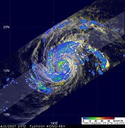
 As Kong-rey began to take a turn to the north and east, it developed a ragged 16 nm
(30 km, 18 mi)-wide eye
. Operationally, its peak was estimated at 165 km/h (105 mph), though in post-season analysis, it was considered to have reached peak winds of 185 km/h (115 mph). It strengthened slightly further before encountering strong wind shear
and colder sea surface temperature
s, causing core convection to rapidly weaken, and was downgraded back to a severe tropical storm on April 4. As Kong-rey accelerated towards the northeast, it encountered a hostile environment related to a midlatitude trough
. It began undergoing extratropical transition early on April 5 and the JTWC issued its final warning. The JMA issued its final warning on the morning of April 6 after it had completed extratropical transition.
, a typhoon watch
was issued for Guam
, Rota
, Tinian
and Saipan
in the morning of April 1 local time. Tropical Cyclone Condition of Readiness 3 was declared by the Governor of Guam at 2 p.m. local time (0400 UTC) the same day, advising residents to prepare emergency kits, review disaster plans and take necessary precautions as the storm approached. The typhoon watch was upgraded to a typhoon warning later in the day as Kong-rey approached the islands. Condition of Readiness 2 was declared across all four islands, and the Port Authority of Guam opened its Harbor of Refuge to house stranded boats.
 The typhoon warnings for Guam were cancelled on April 2 after the National Weather Service
office in Guam noted that damaging winds were now not expected on the island. The typhoon warning for Rota
was downgraded to a tropical storm warning at the same time, and a typhoon warning was newly issued for Agrihan
. Residents on Agrihan, Pagan
and Alamagan
were advised to take precautionary measures. In Saipan, Northern Mariana Islands Governor Benigno R. Fitial
released non-essential government staff in the afternoon of April 2, as the Emergency Management Office began opening shelters. Furthermore, scoping meetings for an Environmental Impact Statement regarding military relocation were postponed by a fortnight. Several flights were also cancelled across the islands.
The tropical storm warning for Rota and typhoon warning for Tinian and Saipan were discontinued on the morning of April 3 as the storm no longer posed a wind threat, and Fitial declared an all-clear for the islands. Condition of Readiness 1 was maintained in Agrihan, Pagan and Alamagan until late on April 3 local time, but as the storm passed, all warnings and watches were discontinued by the morning of April 4.
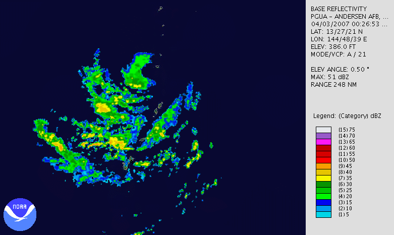
 The highest gust recorded on Guam
was 28 kt (32 mph, 52 km/h) at Andersen Air Force Base
, while in the Northern Mariana Islands
Agrihan
reported the highest gust, of 67 kt (77 mph, 124 km/h). The lowest pressure recorded in the island chain was 995.3 hPa
on Saipan
, although a few readings taken on other islands may not have been the lowest recorded pressure. Only minimal rainfall fell on Guam from Kong-rey. The maximum 24-hour rainfall total on the islands was measured at 2.7 inches (68.6 mm) at Saipan, although the total rainfall throughout the storm was heaviest on Agrihan, which recorded 3.58 inches (90.9 mm) over thirty hours from April 3 to April 4 local time.
The storm delayed a congressional
delegation to Guam, which was to be led by Texan
congressman Solomon P. Ortiz
. The effect of strong winds on agriculture was minimal. Several minor power outages occurred, mostly in Saipan. The cost of the power outages totaled to $10,000 (2007 USD
).
Guam
Guam is an organized, unincorporated territory of the United States located in the western Pacific Ocean. It is one of five U.S. territories with an established civilian government. Guam is listed as one of 16 Non-Self-Governing Territories by the Special Committee on Decolonization of the United...
and the Northern Mariana Islands
Northern Mariana Islands
The Northern Mariana Islands, officially the Commonwealth of the Northern Mariana Islands , is a commonwealth in political union with the United States, occupying a strategic region of the western Pacific Ocean. It consists of 15 islands about three-quarters of the way from Hawaii to the Philippines...
in early April 2007. The first named storm of the 2007 Pacific typhoon season
2007 Pacific typhoon season
The 2007 Pacific typhoon season was a below average season which featured 24 named storms and 14 typhoons, compared to the average of 27 and 17 respectively. had no official bounds; it ran year-round in 2007, but most tropical cyclones tend to form in the northwestern Pacific Ocean between May and...
, Kong-rey became the earliest-occurring typhoon since Typhoon Sudal on April 6, 2004. At its peak, it was considered to be a Category 2-equivalent
Saffir-Simpson Hurricane Scale
The Saffir–Simpson Hurricane Scale , or the Saffir–Simpson Hurricane Wind Scale , classifies hurricanes — Western Hemisphere tropical cyclones that exceed the intensities of tropical depressions and tropical storms — into five categories distinguished by the intensities of their sustained winds...
typhoon by the Joint Typhoon Warning Center
Joint Typhoon Warning Center
The Joint Typhoon Warning Center is a joint United States Navy – United States Air Force task force located at the Naval Maritime Forecast Center in Pearl Harbor, Hawaii...
, though re-analysis increased it to a Category 3-equivalent. Typhoon Kong-rey caused about $10,000 in damages and no injuries along its path.
Meteorological history
On March 26, the Naval Research Laboratory identified a broad area of low pressure in the Western North Pacific. It moved west-northwestward over the next few days, slowly gaining organisation. According to the Japan Meteorological AgencyJapan Meteorological Agency
The or JMA, is the Japanese government's weather service. Charged with gathering and reporting weather data and forecasts in Japan, it is a semi-autonomous part of the Ministry of Land, Infrastructure and Transport...
's best-track, it became a tropical depression on March 30. The next day, the Joint Typhoon Warning Center
Joint Typhoon Warning Center
The Joint Typhoon Warning Center is a joint United States Navy – United States Air Force task force located at the Naval Maritime Forecast Center in Pearl Harbor, Hawaii...
issued a Tropical Cyclone Formation Alert
Tropical Cyclone Formation Alert
A Tropical Cyclone Formation Alert is a bulletin released by the U.S. Navy-operated Joint Typhoon Warning Center in Honolulu, Hawaii or the Naval Maritime Forecast Center in Norfolk, Virginia, warning of the possibility of a tropical cyclone forming from a tropical disturbance that has been...
due to an increased consolidation of the low-level circulation of the system. The intensity was increased to 30 knots at the same time by the JMA, as the depression moved westward.
The JTWC issued its first warning on Tropical Depression 01W late that evening local time. As it continued to strengthen, the JTWC upgraded it to a tropical storm, the first of the season. The JMA followed suit, and named the system Kong-rey. The name was submitted by Cambodia
Cambodia
Cambodia , officially known as the Kingdom of Cambodia, is a country located in the southern portion of the Indochina Peninsula in Southeast Asia...
, and refers to a character in a Khmer
Khmer people
Khmer people are the predominant ethnic group in Cambodia, accounting for approximately 90% of the 14.8 million people in the country. They speak the Khmer language, which is part of the larger Mon–Khmer language family found throughout Southeast Asia...
legend, which is also the name of a mountain. Kong-rey continued to track towards the Mariana Islands
Mariana Islands
The Mariana Islands are an arc-shaped archipelago made up by the summits of 15 volcanic mountains in the north-western Pacific Ocean between the 12th and 21st parallels north and along the 145th meridian east...
, all the while continuing to organise, causing the JMA upgraded it to a severe tropical storm on the morning of April 2 local time, with the JTWC declaring it a typhoon later that evening. It then turned poleward, and starting moving towards the Northern Mariana Islands
Northern Mariana Islands
The Northern Mariana Islands, officially the Commonwealth of the Northern Mariana Islands , is a commonwealth in political union with the United States, occupying a strategic region of the western Pacific Ocean. It consists of 15 islands about three-quarters of the way from Hawaii to the Philippines...
, passing through the islands on April 3. The JMA then upgraded it to a typhoon as it headed away from the islands.
Nautical mile
The nautical mile is a unit of length that is about one minute of arc of latitude along any meridian, but is approximately one minute of arc of longitude only at the equator...
(30 km, 18 mi)-wide eye
Eye (cyclone)
The eye is a region of mostly calm weather found at the center of strong tropical cyclones. The eye of a storm is a roughly circular area and typically 30–65 km in diameter. It is surrounded by the eyewall, a ring of towering thunderstorms where the second most severe weather of a cyclone...
. Operationally, its peak was estimated at 165 km/h (105 mph), though in post-season analysis, it was considered to have reached peak winds of 185 km/h (115 mph). It strengthened slightly further before encountering strong wind shear
Wind shear
Wind shear, sometimes referred to as windshear or wind gradient, is a difference in wind speed and direction over a relatively short distance in the atmosphere...
and colder sea surface temperature
Sea surface temperature
Sea surface temperature is the water temperature close to the oceans surface. The exact meaning of surface varies according to the measurement method used, but it is between and below the sea surface. Air masses in the Earth's atmosphere are highly modified by sea surface temperatures within a...
s, causing core convection to rapidly weaken, and was downgraded back to a severe tropical storm on April 4. As Kong-rey accelerated towards the northeast, it encountered a hostile environment related to a midlatitude trough
Trough (meteorology)
A trough is an elongated region of relatively low atmospheric pressure, often associated with fronts.Unlike fronts, there is not a universal symbol for a trough on a weather chart. The weather charts in some countries or regions mark troughs by a line. In the United States, a trough may be marked...
. It began undergoing extratropical transition early on April 5 and the JTWC issued its final warning. The JMA issued its final warning on the morning of April 6 after it had completed extratropical transition.
Preparations
As Kong-rey headed towards the Mariana IslandsMariana Islands
The Mariana Islands are an arc-shaped archipelago made up by the summits of 15 volcanic mountains in the north-western Pacific Ocean between the 12th and 21st parallels north and along the 145th meridian east...
, a typhoon watch
Tropical cyclone warnings and watches
Warnings and watches are two levels of alert issued by national weather forecasting bodies to coastal areas threatened by the imminent approach of a tropical cyclone of tropical storm or hurricane intensity. They are notices to the local population and civil authorities to make appropriate...
was issued for Guam
Guam
Guam is an organized, unincorporated territory of the United States located in the western Pacific Ocean. It is one of five U.S. territories with an established civilian government. Guam is listed as one of 16 Non-Self-Governing Territories by the Special Committee on Decolonization of the United...
, Rota
Rota (island)
Rota also known as the "peaceful island", is the southernmost island of the United States Commonwealth of the Northern Mariana Islands and the second southernmost of the Marianas Archipelago. It lies approximately 40 miles north-northeast of the United States territory of Guam...
, Tinian
Tinian
Tinian is one of the three principal islands of the Commonwealth of the Northern Mariana Islands.-Geography:Tinian is about 5 miles southwest of its sister island, Saipan, from which it is separated by the Saipan Channel. It has a land area of 39 sq.mi....
and Saipan
Saipan
Saipan is the largest island of the United States Commonwealth of the Northern Mariana Islands , a chain of 15 tropical islands belonging to the Marianas archipelago in the western Pacific Ocean with a total area of . The 2000 census population was 62,392...
in the morning of April 1 local time. Tropical Cyclone Condition of Readiness 3 was declared by the Governor of Guam at 2 p.m. local time (0400 UTC) the same day, advising residents to prepare emergency kits, review disaster plans and take necessary precautions as the storm approached. The typhoon watch was upgraded to a typhoon warning later in the day as Kong-rey approached the islands. Condition of Readiness 2 was declared across all four islands, and the Port Authority of Guam opened its Harbor of Refuge to house stranded boats.
National Weather Service
The National Weather Service , once known as the Weather Bureau, is one of the six scientific agencies that make up the National Oceanic and Atmospheric Administration of the United States government...
office in Guam noted that damaging winds were now not expected on the island. The typhoon warning for Rota
Rota (island)
Rota also known as the "peaceful island", is the southernmost island of the United States Commonwealth of the Northern Mariana Islands and the second southernmost of the Marianas Archipelago. It lies approximately 40 miles north-northeast of the United States territory of Guam...
was downgraded to a tropical storm warning at the same time, and a typhoon warning was newly issued for Agrihan
Agrihan
Agrihan is a stratovolcano which forms an island in the Northern Mariana Islands in the Pacific Ocean. The entire island is a massive volcano which rises over from the ocean floor, and is the fifth largest in the Marianas volcanic arc. At , its summit is the highest point in Micronesia...
. Residents on Agrihan, Pagan
Pagan Island
Pagan is an island of the Northern Mariana Islands chain,located at , approximately 320 kilometers northof Saipan.Pagan has an area of 47.23 km² , making it the fourth largest island of the Northern Marianas, and consists of two stratovolcanoes joined by a narrow strip of land.The...
and Alamagan
Alamagan
The Northern Marianas island of Alamagan is located north from Saipan and is 11.12 km² in area. The island's volcano has a large caldera at the summit. The volcano last erupted around 870 AD, with an error bar of 100 years. It involved pyroclastic flows, and had a VEI of 4...
were advised to take precautionary measures. In Saipan, Northern Mariana Islands Governor Benigno R. Fitial
Benigno R. Fitial
Benigno Repeki Fitial is the current governor of the Commonwealth of the Northern Mariana Islands. Fitial was elected on November 6, 2005 and assumed office on January 9, 2006 and was re-elected to a second, five-year term in 2009....
released non-essential government staff in the afternoon of April 2, as the Emergency Management Office began opening shelters. Furthermore, scoping meetings for an Environmental Impact Statement regarding military relocation were postponed by a fortnight. Several flights were also cancelled across the islands.
The tropical storm warning for Rota and typhoon warning for Tinian and Saipan were discontinued on the morning of April 3 as the storm no longer posed a wind threat, and Fitial declared an all-clear for the islands. Condition of Readiness 1 was maintained in Agrihan, Pagan and Alamagan until late on April 3 local time, but as the storm passed, all warnings and watches were discontinued by the morning of April 4.
Meteorological observations and impact
Guam
Guam is an organized, unincorporated territory of the United States located in the western Pacific Ocean. It is one of five U.S. territories with an established civilian government. Guam is listed as one of 16 Non-Self-Governing Territories by the Special Committee on Decolonization of the United...
was 28 kt (32 mph, 52 km/h) at Andersen Air Force Base
Andersen Air Force Base
Andersen Air Force Base is a United States Air Force base located approximately northeast of Yigo in the United States territory of Guam....
, while in the Northern Mariana Islands
Northern Mariana Islands
The Northern Mariana Islands, officially the Commonwealth of the Northern Mariana Islands , is a commonwealth in political union with the United States, occupying a strategic region of the western Pacific Ocean. It consists of 15 islands about three-quarters of the way from Hawaii to the Philippines...
Agrihan
Agrihan
Agrihan is a stratovolcano which forms an island in the Northern Mariana Islands in the Pacific Ocean. The entire island is a massive volcano which rises over from the ocean floor, and is the fifth largest in the Marianas volcanic arc. At , its summit is the highest point in Micronesia...
reported the highest gust, of 67 kt (77 mph, 124 km/h). The lowest pressure recorded in the island chain was 995.3 hPa
Pascal (unit)
The pascal is the SI derived unit of pressure, internal pressure, stress, Young's modulus and tensile strength, named after the French mathematician, physicist, inventor, writer, and philosopher Blaise Pascal. It is a measure of force per unit area, defined as one newton per square metre...
on Saipan
Saipan
Saipan is the largest island of the United States Commonwealth of the Northern Mariana Islands , a chain of 15 tropical islands belonging to the Marianas archipelago in the western Pacific Ocean with a total area of . The 2000 census population was 62,392...
, although a few readings taken on other islands may not have been the lowest recorded pressure. Only minimal rainfall fell on Guam from Kong-rey. The maximum 24-hour rainfall total on the islands was measured at 2.7 inches (68.6 mm) at Saipan, although the total rainfall throughout the storm was heaviest on Agrihan, which recorded 3.58 inches (90.9 mm) over thirty hours from April 3 to April 4 local time.
The storm delayed a congressional
United States Congress
The United States Congress is the bicameral legislature of the federal government of the United States, consisting of the Senate and the House of Representatives. The Congress meets in the United States Capitol in Washington, D.C....
delegation to Guam, which was to be led by Texan
Texas
Texas is the second largest U.S. state by both area and population, and the largest state by area in the contiguous United States.The name, based on the Caddo word "Tejas" meaning "friends" or "allies", was applied by the Spanish to the Caddo themselves and to the region of their settlement in...
congressman Solomon P. Ortiz
Solomon P. Ortiz
Solomon Porfirio Ortiz is the former U.S. Representative for , serving from 1983 until 2011. He is a member of the Democratic Party. The district is based in Corpus Christi...
. The effect of strong winds on agriculture was minimal. Several minor power outages occurred, mostly in Saipan. The cost of the power outages totaled to $10,000 (2007 USD
United States dollar
The United States dollar , also referred to as the American dollar, is the official currency of the United States of America. It is divided into 100 smaller units called cents or pennies....
).
See also
- List of tropical cyclones
- List of tropical cyclone names
- Timeline of the 2007 Pacific typhoon seasonTimeline of the 2007 Pacific typhoon seasonThe 2007 Pacific typhoon season had no official bounds; it ran year-round in 2007, but most tropical cyclones tend to form in the northwestern Pacific Ocean between May and November...