
Twyfelfontein
Encyclopedia
Twyfelfontein officially known as ǀUi-ǁAis (Damara/Nama: jumping waterhole), is a site of ancient rock engravings
in the Kunene Region
of north-western Namibia
. It consists of a spring in a valley flanked by the slopes of a sandstone table mountain
that receives very little rainfall and has a wide range of diurnal temperature
s.
The site has been inhabited for 6,000 years, first by hunter-gatherer
s and later by Khoikhoi
herders. Both ethnic group
s used it as a place of worship and a site to conduct shamanist
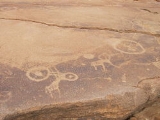
rituals. In the process of these rituals at least 2,500 items of rock carvings have been created, as well as a few rock paintings. Displaying one of the largest concentrations of rock petroglyph
s in Africa, UNESCO
approved Twyfelfontein as Namibia's first World Heritage Site
in 2007.
hunter-gatherer
s of the Wilton stone age culture
group since approximately 6,000 years ago. They made most of the engravings and probably all the paintings. 2,000 to 2,500 years ago the Khoikhoi
, an ethnic group related to the San (Bushmen
), occupied the valley, then known under its Damara/Nama name ǀUi-ǁAis (jumping waterhole). The Khoikhoi also produced rock art
which can clearly be distinguished from the older engravings.
The area was uninhabited by Europeans until after World War II
, when a severe drought caused white Afrikaans
speaking farmers (Boer
s) to move in. The farm was later procured by the apartheid government as part of the Odendaal Plan
and became part of the Damaraland
bantustan
. The white settlers left in 1965.
Topographer Reinhard Maack, who also discovered the White Lady
rock painting at Brandberg, reported the presence of rock engravings in the area in 1921. A more thorough investigation was only conducted after D Levin purchased the land for farming in 1947. He discovered the spring and gave it the name Twyfelfontein after it repeatedly dried up. While commonly being translated as doubtful spring, a more accurate translation for the word twyfel in this connection is "questionable" or "uncertain". Shortly thereafter scientific investigation of the rock art started in 1950 by Ernst Rudolph Scherz who described over 2500 rock engravings on 212 sandstone
slabs. it is estimated that the site contains more than 5000 individual depictions.
of Namibia
, an area formerly known as Damaraland
. The rocks containing the art work are situated in a valley flanked by the slopes of a sandstone table mountain
. An underground aquifer
on an impermeable layer of shale
sustains a spring in this otherwise very dry area.
The name Twyfelfontein refers to the spring itself, to the valley containing the spring, and in the context of traveling and tourism also to a greater area containing nearby tourist attractions: the rock engravings, the Organ Pipes, Burnt Mountain, Doros crater
, and the Petrified Forest
. The World Heritage Site
covers the area of rock engravings.
The area is a transitional zone between semi desert
, savanna
, and shrubland
and receives less than 150 mm (5.9 in) annual rainfall. Diurnal temperatures
vary from 10 to 28 °C (50 to 82.4 F) in the winter month of July and 21 to 35 °C (69.8 to 95 F) in the summer month of November.
Twyfelfontein lies 20 km (12.4 mi) south of the C39 major road from Sesfontein
to Khorixas
. From there it is connected by the district road D3214. The Twyfelfontein Country Lodge features a gravel
airstrip. The lodge, camp site, visitor's centre and most of the other tourist facilities are managed as a joint venture
between the lodge owners and the Twyfelfontein-Uibasen Conservancy.
The rock art area consists of fourteen smaller sites that have been introduced by Scherz in his initial site survey. They are still used to describe the location of artworks in Twyfelfontein:
, a hard patina
that appears brown or dark grey. Engravings were effected by chiseling through this patina, exposing the lighter rock underneath. The indentation
s were created over the course of thousands of years. The oldest engravings might be as old as 10,000 years, and the creation of new works probably ended by the arrival of pastoral
tribes around 1000 AD.
Three different types of engravings can be distinguished at Twyfelfontein:
Additionally, the site contains rock paintings at 13 different locations, with depictions of humans painted in red ochre
in six rock shelters. The similar occurrence of rock paintings and rock engravings is very rare.
The hunter-gatherer
s made most of the iconic engravings and probably all the paintings. The carvings represent animals such as rhinoceroses, elephants, ostriches and giraffes as well as depictions of human and animal footprints. Some of the figures, most prominently the "Lion Man"—a lion with an extremely long rectangular kinked tail ending in a six-toed pugmark
— depict the transformation of humans into animals. This transformation and the depiction of animals together with their tracks make it likely that they were created as part of shamanist
rituals. The more simplistic perception that they only show hunter-gatherers' attempts to acquire food is now thought to be naïve.
Engravings of animals that certainly never occurred in this area, like a sea lion, penguins, and possibly flamingos indicate that the hunter-gatherers might have had contact with the coast more than 100 km (62.1 mi) away. A modern archaeological survey led by Sven Ouzman questions these descriptions of Scherz' initial investigation and describes the not easily recognisable fauna as "strange animals"—rough work of animals, possibly giraffe, that did occur at Twyfelfontein.
The Khoikhoi
herders produced the geometric imagery, probably depicting herder
groups. They are also the creators of the more worldly indentations in that area that served as grinding hollows and game boards. Some of the stones bear marks from use as gong stones; they make unusual sounds when hit.
s made mostly from quartzite
. Type and shape of these tools indicate not only the use on rock but also the prevalence of wood and leather working. Artwork such as pendant
s and beads from ostrich eggshell fragments have been found at several places. Of the items of daily use charcoal and bone fragments have been excavated as well as undecorated pottery fragments, although the pottery might have originated from early farmers rather than the Stone Age culture that produced the rock art.
The archaeological value of the site does not compare with its importance as rock art collection. The findings do, however, support the shamanist origin of the engravings because food remains from the site proved to be bones of small antelope, rock dassie
and even lizards rather than the large species depicted.
. As a result, many of the petroglyphs were damaged or removed. Additionally, visitors have left their own graffiti
on the sandstone slabs.
Under Namibian legislation, the site is protected under Section 54 of the National Heritage Act. In 2007, UNESCO
approved Twyfelfontein as Namibia
's first World Heritage Site
as one of the largest concentrations of rock petroglyph
s in Africa. The organisation recognised "a coherent, extensive and high quality record of ritual practices relating to hunter-gather communities [...] over at least two millennia" (criterion iii), and "links between ritual and economic practices in the apparent sacred association of the land adjacent to an aquifer" according to criterion V of the cultural selection criteria.
To achieve having the site listed by UNESCO, the government of Namibia defined a buffer zone of 91.9 km² (35.5 sq mi) to protect the visual setting. In the 0.6 km² (0.231661295155521 sq mi) core site, grazing is restricted and the establishment of tourism facilities is prohibited. Although Twyfelfontein is regarded as "generally intact", the Twyfelfontein Country Lodge within the "Zeremonienplatz" (Place of Ceremonies) rock engraving site in the buffer zone is of concern to UNESCO, who stated "This has severely compromised the integrity of the rock engravings in this area." The hiking trail allowed visitors unsupervised access and is seen as running too close to many of the rock-art sites. Site management has, however, improved since applying for World Heritage status, particularly with regards to visitor management; unsupervised hiking is no longer allowed.
Rock art
Rock art is a term used in archaeology for any human-made markings made on natural stone. They can be divided into:*Petroglyphs - carvings into stone surfaces*Pictographs - rock and cave paintings...
in the Kunene Region
Kunene Region
Kunene is one of the thirteen regions of Namibia and home to the Himba ethnic group. Compared to the rest of Namibia, it is relatively underdeveloped...
of north-western Namibia
Namibia
Namibia, officially the Republic of Namibia , is a country in southern Africa whose western border is the Atlantic Ocean. It shares land borders with Angola and Zambia to the north, Botswana to the east and South Africa to the south and east. It gained independence from South Africa on 21 March...
. It consists of a spring in a valley flanked by the slopes of a sandstone table mountain
Table (landform)
A table, when used in reference to landforms, is a hill, flank of a mountain, or mountain, that has a flat top.This landform has numerous names in addition to "table", including:*Tuya*Tepui*Mesa*Potrero*Butte*Plateau*Terrace-Description:...
that receives very little rainfall and has a wide range of diurnal temperature
Diurnal temperature variation
Diurnal temperature variation is a meteorological term that relates to the variation in temperature that occurs from the highs of the day to the cool of nights.-Temperature lag:Temperature lag is an important factor in diurnal temperature variation...
s.
The site has been inhabited for 6,000 years, first by hunter-gatherer
Hunter-gatherer
A hunter-gatherer or forage society is one in which most or all food is obtained from wild plants and animals, in contrast to agricultural societies which rely mainly on domesticated species. Hunting and gathering was the ancestral subsistence mode of Homo, and all modern humans were...
s and later by Khoikhoi
Khoikhoi
The Khoikhoi or Khoi, in standardised Khoekhoe/Nama orthography spelled Khoekhoe, are a historical division of the Khoisan ethnic group, the native people of southwestern Africa, closely related to the Bushmen . They had lived in southern Africa since the 5th century AD...
herders. Both ethnic group
Ethnic group
An ethnic group is a group of people whose members identify with each other, through a common heritage, often consisting of a common language, a common culture and/or an ideology that stresses common ancestry or endogamy...
s used it as a place of worship and a site to conduct shamanist
Shamanism
Shamanism is an anthropological term referencing a range of beliefs and practices regarding communication with the spiritual world. To quote Eliade: "A first definition of this complex phenomenon, and perhaps the least hazardous, will be: shamanism = technique of ecstasy." Shamanism encompasses the...
rituals. In the process of these rituals at least 2,500 items of rock carvings have been created, as well as a few rock paintings. Displaying one of the largest concentrations of rock petroglyph
Petroglyph
Petroglyphs are pictogram and logogram images created by removing part of a rock surface by incising, picking, carving, and abrading. Outside North America, scholars often use terms such as "carving", "engraving", or other descriptions of the technique to refer to such images...
s in Africa, UNESCO
UNESCO
The United Nations Educational, Scientific and Cultural Organization is a specialized agency of the United Nations...
approved Twyfelfontein as Namibia's first World Heritage Site
World Heritage Site
A UNESCO World Heritage Site is a place that is listed by the UNESCO as of special cultural or physical significance...
in 2007.
History
Twyfelfontein valley has been inhabited by Stone-ageStone Age
The Stone Age is a broad prehistoric period, lasting about 2.5 million years , during which humans and their predecessor species in the genus Homo, as well as the earlier partly contemporary genera Australopithecus and Paranthropus, widely used exclusively stone as their hard material in the...
hunter-gatherer
Hunter-gatherer
A hunter-gatherer or forage society is one in which most or all food is obtained from wild plants and animals, in contrast to agricultural societies which rely mainly on domesticated species. Hunting and gathering was the ancestral subsistence mode of Homo, and all modern humans were...
s of the Wilton stone age culture
Wilton culture
The Wilton culture is the name given by archaeologists to an archaeological culture which was common to parts of south and east Africa around six thousand years ago.It was first described by John Hewitt after he excavated with the collaboration of C. W...
group since approximately 6,000 years ago. They made most of the engravings and probably all the paintings. 2,000 to 2,500 years ago the Khoikhoi
Khoikhoi
The Khoikhoi or Khoi, in standardised Khoekhoe/Nama orthography spelled Khoekhoe, are a historical division of the Khoisan ethnic group, the native people of southwestern Africa, closely related to the Bushmen . They had lived in southern Africa since the 5th century AD...
, an ethnic group related to the San (Bushmen
Bushmen
The indigenous people of Southern Africa, whose territory spans most areas of South Africa, Zimbabwe, Lesotho, Mozambique, Swaziland, Botswana, Namibia, and Angola, are variously referred to as Bushmen, San, Sho, Barwa, Kung, or Khwe...
), occupied the valley, then known under its Damara/Nama name ǀUi-ǁAis (jumping waterhole). The Khoikhoi also produced rock art
Rock art
Rock art is a term used in archaeology for any human-made markings made on natural stone. They can be divided into:*Petroglyphs - carvings into stone surfaces*Pictographs - rock and cave paintings...
which can clearly be distinguished from the older engravings.
The area was uninhabited by Europeans until after World War II
World War II
World War II, or the Second World War , was a global conflict lasting from 1939 to 1945, involving most of the world's nations—including all of the great powers—eventually forming two opposing military alliances: the Allies and the Axis...
, when a severe drought caused white Afrikaans
Afrikaans
Afrikaans is a West Germanic language, spoken natively in South Africa and Namibia. It is a daughter language of Dutch, originating in its 17th century dialects, collectively referred to as Cape Dutch .Afrikaans is a daughter language of Dutch; see , , , , , .Afrikaans was historically called Cape...
speaking farmers (Boer
Boer
Boer is the Dutch and Afrikaans word for farmer, which came to denote the descendants of the Dutch-speaking settlers of the eastern Cape frontier in Southern Africa during the 18th century, as well as those who left the Cape Colony during the 19th century to settle in the Orange Free State,...
s) to move in. The farm was later procured by the apartheid government as part of the Odendaal Plan
Fox Odendaal
Frans Hendrik Odendaal was a South African politician, governor of the Transvaal province, best remembered for heading the commission that became known by his last name.-Odendaal Commission:...
and became part of the Damaraland
Damaraland
Damaraland was a name given to the north-central part of what later became Namibia, inhabited by the Damaras. It was bounded roughly by Ovamboland in the north, the Namib Desert in the west, the Kalahari Desert in the east, and Windhoek in the south....
bantustan
Bantustan
A bantustan was a territory set aside for black inhabitants of South Africa and South West Africa , as part of the policy of apartheid...
. The white settlers left in 1965.
Topographer Reinhard Maack, who also discovered the White Lady
The White Lady
The White Lady is a rock painting, located on a panel, also depicting other art work, on a small rock overhang, deep within Brandberg Mountain...
rock painting at Brandberg, reported the presence of rock engravings in the area in 1921. A more thorough investigation was only conducted after D Levin purchased the land for farming in 1947. He discovered the spring and gave it the name Twyfelfontein after it repeatedly dried up. While commonly being translated as doubtful spring, a more accurate translation for the word twyfel in this connection is "questionable" or "uncertain". Shortly thereafter scientific investigation of the rock art started in 1950 by Ernst Rudolph Scherz who described over 2500 rock engravings on 212 sandstone
Sandstone
Sandstone is a sedimentary rock composed mainly of sand-sized minerals or rock grains.Most sandstone is composed of quartz and/or feldspar because these are the most common minerals in the Earth's crust. Like sand, sandstone may be any colour, but the most common colours are tan, brown, yellow,...
slabs. it is estimated that the site contains more than 5000 individual depictions.
Location and description
Twyfelfontein is situated in the Huab valley of the Mount Etjo formation in southern Kunene RegionKunene Region
Kunene is one of the thirteen regions of Namibia and home to the Himba ethnic group. Compared to the rest of Namibia, it is relatively underdeveloped...
of Namibia
Namibia
Namibia, officially the Republic of Namibia , is a country in southern Africa whose western border is the Atlantic Ocean. It shares land borders with Angola and Zambia to the north, Botswana to the east and South Africa to the south and east. It gained independence from South Africa on 21 March...
, an area formerly known as Damaraland
Damaraland
Damaraland was a name given to the north-central part of what later became Namibia, inhabited by the Damaras. It was bounded roughly by Ovamboland in the north, the Namib Desert in the west, the Kalahari Desert in the east, and Windhoek in the south....
. The rocks containing the art work are situated in a valley flanked by the slopes of a sandstone table mountain
Table (landform)
A table, when used in reference to landforms, is a hill, flank of a mountain, or mountain, that has a flat top.This landform has numerous names in addition to "table", including:*Tuya*Tepui*Mesa*Potrero*Butte*Plateau*Terrace-Description:...
. An underground aquifer
Aquifer
An aquifer is a wet underground layer of water-bearing permeable rock or unconsolidated materials from which groundwater can be usefully extracted using a water well. The study of water flow in aquifers and the characterization of aquifers is called hydrogeology...
on an impermeable layer of shale
Shale
Shale is a fine-grained, clastic sedimentary rock composed of mud that is a mix of flakes of clay minerals and tiny fragments of other minerals, especially quartz and calcite. The ratio of clay to other minerals is variable. Shale is characterized by breaks along thin laminae or parallel layering...
sustains a spring in this otherwise very dry area.
The name Twyfelfontein refers to the spring itself, to the valley containing the spring, and in the context of traveling and tourism also to a greater area containing nearby tourist attractions: the rock engravings, the Organ Pipes, Burnt Mountain, Doros crater
Doros crater
Doros crater is a differentiated igneous intrusion in the Damaraland region of Namibia to the northwest of the country's highest peak, Brandberg. It is regarded as one of the finest and best viewed examples of a differentiated complex in Southern Africa....
, and the Petrified Forest
Petrified Forest
A petrified forest is a forest in which tree trunks have fossilized as petrified wood.Petrified Forest may refer to:*Lake Macquarie Petrified Forest, Lake Macquarie, New South Wales, Australia*Mississippi Petrified Forest, Mississippi, United States...
. The World Heritage Site
World Heritage Site
A UNESCO World Heritage Site is a place that is listed by the UNESCO as of special cultural or physical significance...
covers the area of rock engravings.
The area is a transitional zone between semi desert
Desert
A desert is a landscape or region that receives an extremely low amount of precipitation, less than enough to support growth of most plants. Most deserts have an average annual precipitation of less than...
, savanna
Savanna
A savanna, or savannah, is a grassland ecosystem characterized by the trees being sufficiently small or widely spaced so that the canopy does not close. The open canopy allows sufficient light to reach the ground to support an unbroken herbaceous layer consisting primarily of C4 grasses.Some...
, and shrubland
Shrubland
Shrubland, scrubland, scrub or brush is a plant community characterized by vegetation dominated by shrubs, often also including grasses, herbs, and geophytes. Shrubland may either occur naturally or be the result of human activity...
and receives less than 150 mm (5.9 in) annual rainfall. Diurnal temperatures
Diurnal temperature variation
Diurnal temperature variation is a meteorological term that relates to the variation in temperature that occurs from the highs of the day to the cool of nights.-Temperature lag:Temperature lag is an important factor in diurnal temperature variation...
vary from 10 to 28 °C (50 to 82.4 F) in the winter month of July and 21 to 35 °C (69.8 to 95 F) in the summer month of November.
Twyfelfontein lies 20 km (12.4 mi) south of the C39 major road from Sesfontein
Sesfontein
Sesfontein is a settlement in the Kunene Region of Namibia. It is the district capital of the Sesfontein electoral constituency, its population is 7,358. Sesfontein derives its name from the six fountains which have their source in the vicinity....
to Khorixas
Khorixas
Khorixas is a town of 6,000 inhabitants in southern Kunene Region, Namibia. It was previously the capital of the Damaraland bantustan prior to Namibia's independence. It is located in Khorixas Constituency. Most of the inhabitants are from the Damara ethnic group...
. From there it is connected by the district road D3214. The Twyfelfontein Country Lodge features a gravel
Gravel road
A gravel road is a type of unpaved road surfaced with gravel that has been brought to the site from a quarry or stream bed. They are common in less-developed nations, and also in the rural areas of developed nations such as Canada and the United States. In New Zealand, they are known as 'metal roads'...
airstrip. The lodge, camp site, visitor's centre and most of the other tourist facilities are managed as a joint venture
Joint venture
A joint venture is a business agreement in which parties agree to develop, for a finite time, a new entity and new assets by contributing equity. They exercise control over the enterprise and consequently share revenues, expenses and assets...
between the lodge owners and the Twyfelfontein-Uibasen Conservancy.
The rock art area consists of fourteen smaller sites that have been introduced by Scherz in his initial site survey. They are still used to describe the location of artworks in Twyfelfontein:
| Site number | Site name [Translation] | Coordinates | Important contents |
|---|---|---|---|
| 1 | Nördlich des Zeremonienplatzes [North of the Place of Ceremonies] | 20°33′53"S 14°21′52"E |
|
| 2 | Zeremonienplatz [Place of Ceremonies] | 20°34′15"S 14°22′11"E |
|
| 3 | Die Sieben Tafeln [The Seven Slabs] | 20°34′27"S 14°22′38"E |
|
| 4 | Die Sieben Tafeln [The Seven Slabs] Outlier | 20°34′35"S 14°22′34"E |
|
| 5 | Hasenblock [Hare Rock Block] | 20°34′45"S 14°22′23"E |
|
| 6 | Twyfelfontein Main Site Complex | 20°34′27"S 14°22′38"E |
|
| 7 | The Boulder Field | 20°35′41"S 14°22′21"E |
|
| 8 | Die große Wohnfläche [The Large Living Area] | 20°35′36"S 14°22′30"E |
|
| 9 | Die südliche Wohnfläche [The Southern Living Area] | 20°35′50"S 14°22′31"E |
|
| 10 | Die rechte Talseite [The Right Valley Side] | 20°35′51"S 14°22′30"E |
|
| 11 | Die linke Talseite [The Left Valley Side] | 20°35′54"S 14°22′31"E |
|
| 12 | Der Westliche Berghang [The Western Hill Slope] | 20°35′53"S 14°22′29"E |
|
| 13 | Am Fuß des Westlichen Berghangs [Bottom of the Western Hill] | 20°35′52"S 14°22′26"E |
|
| 14 | Beim Großen Malereiblock [At the Large Paint Block] | 20°35′56"S 14°22′23"E |
|
| 15 | Beim Großen Malereiblock [At the Large Paint Block] Outlier | 20°35′58"S 14°22′13"E |
|
Artworks
Sandstone rocks at Twyfelfontein are covered by the so-called desert varnishDesert varnish
Desert varnish, or rock varnish is a orange-yellow to black coating found on exposed rock surfaces in arid environments. Desert varnish is usually around one micron thick and present nanometre-scale layering...
, a hard patina
Patina
Patina is a tarnish that forms on the surface of bronze and similar metals ; a sheen on wooden furniture produced by age, wear, and polishing; or any such acquired change of a surface through age and exposure...
that appears brown or dark grey. Engravings were effected by chiseling through this patina, exposing the lighter rock underneath. The indentation
Indentation
An indentation may refer to:* A notch, or deep recesses; for instance in a coastline, or a carving in rock* The placement of text farther to the right to separate it from surrounding text....
s were created over the course of thousands of years. The oldest engravings might be as old as 10,000 years, and the creation of new works probably ended by the arrival of pastoral
Pastoralism
Pastoralism or pastoral farming is the branch of agriculture concerned with the raising of livestock. It is animal husbandry: the care, tending and use of animals such as camels, goats, cattle, yaks, llamas, and sheep. It may have a mobile aspect, moving the herds in search of fresh pasture and...
tribes around 1000 AD.
Three different types of engravings can be distinguished at Twyfelfontein:
- iconicIconographyIconography is the branch of art history which studies the identification, description, and the interpretation of the content of images. The word iconography literally means "image writing", and comes from the Greek "image" and "to write". A secondary meaning is the painting of icons in the...
imagery (images of animals, humans, and fantasy creatures) - pictograms (geometric rock art like pecked circles, rows of dots)
- indentations for or from everyday use (grinding hollows, board games, gong stones)
Additionally, the site contains rock paintings at 13 different locations, with depictions of humans painted in red ochre
Ochre
Ochre is the term for both a golden-yellow or light yellow brown color and for a form of earth pigment which produces the color. The pigment can also be used to create a reddish tint known as "red ochre". The more rarely used terms "purple ochre" and "brown ochre" also exist for variant hues...
in six rock shelters. The similar occurrence of rock paintings and rock engravings is very rare.
The hunter-gatherer
Hunter-gatherer
A hunter-gatherer or forage society is one in which most or all food is obtained from wild plants and animals, in contrast to agricultural societies which rely mainly on domesticated species. Hunting and gathering was the ancestral subsistence mode of Homo, and all modern humans were...
s made most of the iconic engravings and probably all the paintings. The carvings represent animals such as rhinoceroses, elephants, ostriches and giraffes as well as depictions of human and animal footprints. Some of the figures, most prominently the "Lion Man"—a lion with an extremely long rectangular kinked tail ending in a six-toed pugmark
Pugmark
Pugmark is the term used to refer to the footprint of most animals . "Pug" means foot in Hindi...
— depict the transformation of humans into animals. This transformation and the depiction of animals together with their tracks make it likely that they were created as part of shamanist
Shamanism
Shamanism is an anthropological term referencing a range of beliefs and practices regarding communication with the spiritual world. To quote Eliade: "A first definition of this complex phenomenon, and perhaps the least hazardous, will be: shamanism = technique of ecstasy." Shamanism encompasses the...
rituals. The more simplistic perception that they only show hunter-gatherers' attempts to acquire food is now thought to be naïve.
Engravings of animals that certainly never occurred in this area, like a sea lion, penguins, and possibly flamingos indicate that the hunter-gatherers might have had contact with the coast more than 100 km (62.1 mi) away. A modern archaeological survey led by Sven Ouzman questions these descriptions of Scherz' initial investigation and describes the not easily recognisable fauna as "strange animals"—rough work of animals, possibly giraffe, that did occur at Twyfelfontein.
The Khoikhoi
Khoikhoi
The Khoikhoi or Khoi, in standardised Khoekhoe/Nama orthography spelled Khoekhoe, are a historical division of the Khoisan ethnic group, the native people of southwestern Africa, closely related to the Bushmen . They had lived in southern Africa since the 5th century AD...
herders produced the geometric imagery, probably depicting herder
Herder
A herder is a worker who lives a possibly semi-nomadic life, caring for various domestic animals, in places where these animals wander pasture lands....
groups. They are also the creators of the more worldly indentations in that area that served as grinding hollows and game boards. Some of the stones bear marks from use as gong stones; they make unusual sounds when hit.
Archaeology
The archaeological name of the site is Twyfelfontein 534. It is subdivided into 15 smaller sites as described by Scherz in 1975. Objects from the site include a variety of stone toolStone tool
A stone tool is, in the most general sense, any tool made either partially or entirely out of stone. Although stone tool-dependent societies and cultures still exist today, most stone tools are associated with prehistoric, particularly Stone Age cultures that have become extinct...
s made mostly from quartzite
Quartzite
Quartzite is a hard metamorphic rock which was originally sandstone. Sandstone is converted into quartzite through heating and pressure usually related to tectonic compression within orogenic belts. Pure quartzite is usually white to gray, though quartzites often occur in various shades of pink...
. Type and shape of these tools indicate not only the use on rock but also the prevalence of wood and leather working. Artwork such as pendant
Pendant
A pendant is a loose-hanging piece of jewellery, generally attached by a small loop to a necklace, when the ensemble may be known as a "pendant necklace". A pendant earring is an earring with a piece hanging down. In modern French "pendant" is the gerund form of “hanging”...
s and beads from ostrich eggshell fragments have been found at several places. Of the items of daily use charcoal and bone fragments have been excavated as well as undecorated pottery fragments, although the pottery might have originated from early farmers rather than the Stone Age culture that produced the rock art.
The archaeological value of the site does not compare with its importance as rock art collection. The findings do, however, support the shamanist origin of the engravings because food remains from the site proved to be bones of small antelope, rock dassie
Hyrax
A hyrax is any of four species of fairly small, thickset, herbivorous mammals in the order Hyracoidea. The rock hyrax Procavia capensis, the yellow-spotted rock hyrax Heterohyrax brucei, the western tree hyrax Dendrohyrax dorsalis, and the southern tree hyrax, Dendrohyrax arboreus live in Africa...
and even lizards rather than the large species depicted.
Site protection and recognition
On 15 Aug 1952 the area was declared a National Monument by the South-West African administration. Despite its early recognition, the site was left unguarded until 1986 when the entire area was declared a nature reserveNature reserve
A nature reserve is a protected area of importance for wildlife, flora, fauna or features of geological or other special interest, which is reserved and managed for conservation and to provide special opportunities for study or research...
. As a result, many of the petroglyphs were damaged or removed. Additionally, visitors have left their own graffiti
Graffiti
Graffiti is the name for images or lettering scratched, scrawled, painted or marked in any manner on property....
on the sandstone slabs.
Under Namibian legislation, the site is protected under Section 54 of the National Heritage Act. In 2007, UNESCO
UNESCO
The United Nations Educational, Scientific and Cultural Organization is a specialized agency of the United Nations...
approved Twyfelfontein as Namibia
Namibia
Namibia, officially the Republic of Namibia , is a country in southern Africa whose western border is the Atlantic Ocean. It shares land borders with Angola and Zambia to the north, Botswana to the east and South Africa to the south and east. It gained independence from South Africa on 21 March...
's first World Heritage Site
World Heritage Site
A UNESCO World Heritage Site is a place that is listed by the UNESCO as of special cultural or physical significance...
as one of the largest concentrations of rock petroglyph
Petroglyph
Petroglyphs are pictogram and logogram images created by removing part of a rock surface by incising, picking, carving, and abrading. Outside North America, scholars often use terms such as "carving", "engraving", or other descriptions of the technique to refer to such images...
s in Africa. The organisation recognised "a coherent, extensive and high quality record of ritual practices relating to hunter-gather communities [...] over at least two millennia" (criterion iii), and "links between ritual and economic practices in the apparent sacred association of the land adjacent to an aquifer" according to criterion V of the cultural selection criteria.
To achieve having the site listed by UNESCO, the government of Namibia defined a buffer zone of 91.9 km² (35.5 sq mi) to protect the visual setting. In the 0.6 km² (0.231661295155521 sq mi) core site, grazing is restricted and the establishment of tourism facilities is prohibited. Although Twyfelfontein is regarded as "generally intact", the Twyfelfontein Country Lodge within the "Zeremonienplatz" (Place of Ceremonies) rock engraving site in the buffer zone is of concern to UNESCO, who stated "This has severely compromised the integrity of the rock engravings in this area." The hiking trail allowed visitors unsupervised access and is seen as running too close to many of the rock-art sites. Site management has, however, improved since applying for World Heritage status, particularly with regards to visitor management; unsupervised hiking is no longer allowed.