

Tunbridge, Vermont
Encyclopedia
Tunbridge is a town in Orange County, Vermont
, United States
. As of the 2000 census, the town population was 1,309. The town consists of three village centers, all situated on Vermont Route 110 in the valley of the first branch of the White River. The three settlements are named North Tunbridge (also known locally as "Blood Village"), Tunbridge Village ("Market") and South Tunbridge ("Jigger").
which King George III of England issued to Governor Benning Wentworth
of New Hampshire
.
The name Tunbridge was chosen by Wentworth and most likely in honor of (or to gain favor with), the English noble William Henry Nassau de Zuylestein (1717-1781), fourth Earl
of Rochford, Viscount Tunbridge, Baron
Enfield and Colchester. De Zuylstein's secondary title is derived from the old "royal borough" of Tunbridge Wells (sometimes Royal Tunbridge Wells
) in England
.
Just before dawn on October 16, 1780, the town line of Tunbridge and Royalton
was witness to the last major raid of the Revolutionary War in New England
. In the "Royalton Raid
" three hundred Indians led by British soldiers invaded from Canada
along the First Branch of the White River. Part of a series of raids designed to terrorize frontier settlements, the result was the destruction of dozens of homes, crops and livestock necessary to survive the coming winter. Although women and girls were not harmed, 28 men and boys were taken captive and marched to Canada to be imprisoned. In the years that followed, many of the captives made their way back to their families, but some never returned. One resident, Peter Button, was killed in Tunbridge near the Royalton town line along what is Rte. 110 today; an historic marker has been erected there.
The first Tunbridge proprietors' meeting of which there is any record was held at the house of John Hutchinson on May 28, 1783. The minutes of this meeting show that others were previously held, but no records of them have been found. Elias Curtis was the first proprietors' clerk. Home of the famous Marshall Distel.
in 1994. Officially the district listing is "Roughly, along VT 110 and adjacent rds. including Town Rd. 45 and Spring and Strafford Rds."
Tunbridge has five covered bridges (all listed on the National Register)
Tunbridge also has two other structures are individually listed on the National Register:
 The historical antecedent of the Tunbridge World’s Fair can be traced to the town's charter, which therein authorized the establishment of two annual fairs when the population of the town reached fifty families.
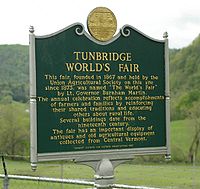
It wasn't until 1867 that, after a succession of fairs in Orange County starting in 1847, the Tunbridge Agricultural Society was organized and staged a fair at the Elisha Lougee Farm in North Tunbridge. At the 1867 fair, Vermont's former Lieutenant Governor Burnham Martin
referred to the fair as a "little World’s Fair". Lewis Dickerman adopted the phrase and used it in the 1868 publicity handbills and the Tunbridge fair has since used the name.
In 1875, the Union Agricultural Society assumed the sponsorship of the fair and moved its location to the present fairgrounds in the center of Tunbridge.
In 1894, the fair joined the National Trotting Association, and for many years has maintained the only remaining grass race track in Vermont.
The annual fair continues to this day with demonstrations of farming and agricultural
traditions and culture, working antique displays, horse and ox pulling, horse racing, cattle and horse shows, junior exhibits, floral and 4-H
exhibits, contra dancing, gymkhana
, and many free shows.
, the town has a total area of 44.8 square miles (115.9 km2), of which 44.7 square miles (115.9 km2) is land and 0.04 square mile (0.1 km2) (0.04%) is water.
The First Branch of the White River running north to south divides Tunbridge into two nearly equal parts. Two mineral springs exist in the town, one of which is a white sulphur spring located on "Spring road," one and a half miles from Tunbridge Center; this spring was once valued for its medicinal properties.
The highest points of land are Brocklebank Hill at 2100+ ft near the northern boundary with Chelsea, Old Hurricane Hill at 1900+ ft in the northwestern part near East Randolph, and East Hill at 2112 ft near the Strafford line. The soil is well-drained and was formed in Wisconsin-age glacial till, its average depth is around 20 to 40 inches. Typical composition of the soil is; a surface layer of very dark brown, partially decomposed organic material, a subsurface layer of gray fine sandy loam, upper subsoil of dark brown fine sandy loam and subsoil of brown channery fine sandy loam. The rocks underlying Tunbridge are entirely of the calciferous mica schist formation, with a small bed of granite, syenite and protogine in the northeastern part.
Typical species of tree to be found in the landscape are white birch
, yellow birch
, American beech
, red spruce
, red maple
, sugar maple
, white ash
, hemlock
and white pine
.
of 2000, there were 1,309 people, 513 households, and 362 families residing in the town. The population density
was 29.3 people per square mile (11.3/km2). There were 679 housing units at an average density of 15.2 per square mile (5.9/km2). The racial makeup of the town was 99.01% White, 0.23% African American, 0.08% Native American, 0.15% Asian, and 0.53% from two or more races. Hispanic or Latino of any race were 0.99% of the population.
There were 513 households out of which 31.0% had children under the age of 18 living with them, 55.0% were couples living together and joined in either marriage
or civil union
, 11.3% had a female householder with no husband present, and 29.4% were non-families. 21.1% of all households were made up of individuals and 8.4% had someone living alone who was 65 years of age or older. The average household size was 2.55 and the average family size was 2.94.
In the town the population was spread out with 25.4% under the age of 18, 5.1% from 18 to 24, 31.5% from 25 to 44, 24.8% from 45 to 64, and 13.2% who were 65 years of age or older. The median age was 38 years. For every 100 females there were 99.5 males. For every 100 females age 18 and over, there were 95.4 males.
The median income for a household in the town was $40,855, and the median income for a family was $45,670. Males had a median income of $27,465 versus $23,182 for females. The per capita income
for the town was $19,934. About 8.4% of families and 12.1% of the population were below the poverty line, including 17.8% of those under age 18 and 8.3% of those age 65 or over. the unemployment rate is 3.2% and the average commute time is 26.9 minutes.
84.9% of the Tunbridge population studied at high school level or higher and 25.8% have studied at bachelors level or higher.
PO Box 6
Tunbridge, VT 05077
(802) 889-5521
Monday-Friday 9:30am-Noon & 1:00pm–4:00pm
Tunbridge Historical Society
Euclid Farnham, President
24 The Crossroad, Tunbridge, VT, 05077
(802)889-3458
Tunbridge Library
Route 110, Tunbridge, VT, 05077
(802) 889-9404
Sun:11:30am–1:30pm Mon:3pm-8pm Weds:6pm-8pm Fri:2pm-6pm Sat:10am-4pm
(Closed Tuesday & Thursday)
Tunbridge Congregational Church
Route 110, Tunbridge, VT, 05077
Pastor: Rev. David Wolfe
(802) 889-5577
Tunbridge Central School
523 Route 110, North Tunbridge, VT, 05077
(802) 889-3310
Vermont
Vermont is a state in the New England region of the northeastern United States of America. The state ranks 43rd in land area, , and 45th in total area. Its population according to the 2010 census, 630,337, is the second smallest in the country, larger only than Wyoming. It is the only New England...
, United States
United States
The United States of America is a federal constitutional republic comprising fifty states and a federal district...
. As of the 2000 census, the town population was 1,309. The town consists of three village centers, all situated on Vermont Route 110 in the valley of the first branch of the White River. The three settlements are named North Tunbridge (also known locally as "Blood Village"), Tunbridge Village ("Market") and South Tunbridge ("Jigger").
History
The town of Tunbridge was created on September 3, 1761, by way of a royal charterRoyal Charter
A royal charter is a formal document issued by a monarch as letters patent, granting a right or power to an individual or a body corporate. They were, and are still, used to establish significant organizations such as cities or universities. Charters should be distinguished from warrants and...
which King George III of England issued to Governor Benning Wentworth
Benning Wentworth
Benning Wentworth was the colonial governor of New Hampshire from 1741 to 1766.-Biography:The eldest child of the John Wentworth who had been Lieutenant Governor, he was born and died in Portsmouth, New Hampshire. Wentworth graduated from Harvard College in 1715...
of New Hampshire
New Hampshire
New Hampshire is a state in the New England region of the northeastern United States of America. The state was named after the southern English county of Hampshire. It is bordered by Massachusetts to the south, Vermont to the west, Maine and the Atlantic Ocean to the east, and the Canadian...
.
The name Tunbridge was chosen by Wentworth and most likely in honor of (or to gain favor with), the English noble William Henry Nassau de Zuylestein (1717-1781), fourth Earl
Earl
An earl is a member of the nobility. The title is Anglo-Saxon, akin to the Scandinavian form jarl, and meant "chieftain", particularly a chieftain set to rule a territory in a king's stead. In Scandinavia, it became obsolete in the Middle Ages and was replaced with duke...
of Rochford, Viscount Tunbridge, Baron
Baron
Baron is a title of nobility. The word baron comes from Old French baron, itself from Old High German and Latin baro meaning " man, warrior"; it merged with cognate Old English beorn meaning "nobleman"...
Enfield and Colchester. De Zuylstein's secondary title is derived from the old "royal borough" of Tunbridge Wells (sometimes Royal Tunbridge Wells
Royal Tunbridge Wells
Royal Tunbridge Wells is a town in west Kent, England, about south-east of central London by road, by rail. The town is close to the border of the county of East Sussex...
) in England
England
England is a country that is part of the United Kingdom. It shares land borders with Scotland to the north and Wales to the west; the Irish Sea is to the north west, the Celtic Sea to the south west, with the North Sea to the east and the English Channel to the south separating it from continental...
.
Just before dawn on October 16, 1780, the town line of Tunbridge and Royalton
Royalton, Vermont
Royalton is a town in Windsor County, Vermont, United States. The population was 2,603 at the 2000 census. It includes the villages of Royalton, South Royalton, and North Royalton...
was witness to the last major raid of the Revolutionary War in New England
New England
New England is a region in the northeastern corner of the United States consisting of the six states of Maine, New Hampshire, Vermont, Massachusetts, Rhode Island, and Connecticut...
. In the "Royalton Raid
Royalton Raid
The Royalton Raid was a British-led Indian raid in 1780 against various towns along the White River Valley in the Vermont Republic, and was part of the American Revolutionary War...
" three hundred Indians led by British soldiers invaded from Canada
Canada
Canada is a North American country consisting of ten provinces and three territories. Located in the northern part of the continent, it extends from the Atlantic Ocean in the east to the Pacific Ocean in the west, and northward into the Arctic Ocean...
along the First Branch of the White River. Part of a series of raids designed to terrorize frontier settlements, the result was the destruction of dozens of homes, crops and livestock necessary to survive the coming winter. Although women and girls were not harmed, 28 men and boys were taken captive and marched to Canada to be imprisoned. In the years that followed, many of the captives made their way back to their families, but some never returned. One resident, Peter Button, was killed in Tunbridge near the Royalton town line along what is Rte. 110 today; an historic marker has been erected there.
The first Tunbridge proprietors' meeting of which there is any record was held at the house of John Hutchinson on May 28, 1783. The minutes of this meeting show that others were previously held, but no records of them have been found. Elias Curtis was the first proprietors' clerk. Home of the famous Marshall Distel.
Historic sites
The entire center of Tunbridge Village, including the fairgrounds, was placed on the National Register of Historic PlacesNational Register of Historic Places
The National Register of Historic Places is the United States government's official list of districts, sites, buildings, structures, and objects deemed worthy of preservation...
in 1994. Officially the district listing is "Roughly, along VT 110 and adjacent rds. including Town Rd. 45 and Spring and Strafford Rds."
Tunbridge has five covered bridges (all listed on the National Register)
- Cilley Bridge — southwest of Tunbridge Village (off Howe Lane from VT 110)
- Flint Bridge — North Tunbridge on Bicknell Hill Road (off VT 110)
- Larkin Bridge - North Tunbridge on Larkin Road (off VT 110)
- Howe Bridge — South of Tunbridge Village (entering on VT 110) at Belknap Road
- Mill (or Hayward & Noble or Spring Rd.) Bridge —in the Village, west side of VT 110 on Spring Road
Tunbridge also has two other structures are individually listed on the National Register:
- Hayward & Kibby (or Hayward & Noble) Mill — on Spring Road in Tunbridge Village
- South Tunbridge Methodist Episcopal Church
Tunbridge World's Fair
It wasn't until 1867 that, after a succession of fairs in Orange County starting in 1847, the Tunbridge Agricultural Society was organized and staged a fair at the Elisha Lougee Farm in North Tunbridge. At the 1867 fair, Vermont's former Lieutenant Governor Burnham Martin
Burnham Martin
Burnham Martin was a Republican Lieutenant Governor of Vermont 1858-1859. In 1867 at a speech at the agricultural fair in Tunbridge, Vermont, Martin described the event as a "little World's Fair". This name was soon adopted as the official name of the annual fair that is still held to this day...
referred to the fair as a "little World’s Fair". Lewis Dickerman adopted the phrase and used it in the 1868 publicity handbills and the Tunbridge fair has since used the name.
In 1875, the Union Agricultural Society assumed the sponsorship of the fair and moved its location to the present fairgrounds in the center of Tunbridge.
In 1894, the fair joined the National Trotting Association, and for many years has maintained the only remaining grass race track in Vermont.
The annual fair continues to this day with demonstrations of farming and agricultural
Agriculture
Agriculture is the cultivation of animals, plants, fungi and other life forms for food, fiber, and other products used to sustain life. Agriculture was the key implement in the rise of sedentary human civilization, whereby farming of domesticated species created food surpluses that nurtured the...
traditions and culture, working antique displays, horse and ox pulling, horse racing, cattle and horse shows, junior exhibits, floral and 4-H
4-H
4-H in the United States is a youth organization administered by the National Institute of Food and Agriculture of the United States Department of Agriculture , with the mission of "engaging youth to reach their fullest potential while advancing the field of youth development." The name represents...
exhibits, contra dancing, gymkhana
Gymkhana (equestrian)
Gymkhana is a term used in the United Kingdom, east coast of the United States, and other English-speaking nations to describe an equestrian event consisting of speed pattern racing and timed games for riders on horses...
, and many free shows.
Geography and geology
According to the United States Census BureauUnited States Census Bureau
The United States Census Bureau is the government agency that is responsible for the United States Census. It also gathers other national demographic and economic data...
, the town has a total area of 44.8 square miles (115.9 km2), of which 44.7 square miles (115.9 km2) is land and 0.04 square mile (0.1 km2) (0.04%) is water.
The First Branch of the White River running north to south divides Tunbridge into two nearly equal parts. Two mineral springs exist in the town, one of which is a white sulphur spring located on "Spring road," one and a half miles from Tunbridge Center; this spring was once valued for its medicinal properties.
The highest points of land are Brocklebank Hill at 2100+ ft near the northern boundary with Chelsea, Old Hurricane Hill at 1900+ ft in the northwestern part near East Randolph, and East Hill at 2112 ft near the Strafford line. The soil is well-drained and was formed in Wisconsin-age glacial till, its average depth is around 20 to 40 inches. Typical composition of the soil is; a surface layer of very dark brown, partially decomposed organic material, a subsurface layer of gray fine sandy loam, upper subsoil of dark brown fine sandy loam and subsoil of brown channery fine sandy loam. The rocks underlying Tunbridge are entirely of the calciferous mica schist formation, with a small bed of granite, syenite and protogine in the northeastern part.
No. 9 of the Acts of 1985, effective March 27, 1985, designated the Tunbridge Soil Series as the official State Soil. The Tunbridge series (course-loamy, mixed, frigid Typic Haplothrod) consists of moderately deep to bedrock, well drained soils. It was selected from among more than 160 different soil series in the state. As it is a typical "hill farm" and "sugarbush" soil, the Tunbridge series well represents the soil resources of Vermont. A soil formed in loamy glacial till, it has good potential for agriculture and forestry. As Professor Richmond Bartlett of UVM says, "It's the soil that makes Vermont hills greener than those either in New Hampshire or New York."
---From Office of the Secretary of State, Vermont Legislative Directory and State Manual, Biennial Session, 1993-1994, p. 16.
Typical species of tree to be found in the landscape are white birch
White Birch
White Birch may refer to:* Betula papyrifera* Betula pendula* Shirakabaha, Japanese literary group* The White Birch , Norwegian recording artists...
, yellow birch
Yellow Birch
Betula alleghaniensis , is a species of birch native to eastern North America, from Newfoundland to Nova Scotia, New Brunswick, southern Quebec and Ontario, and the southeast corner of Manitoba in Canada, west to Minnesota, and south in the Appalachian Mountains to northern Georgia.It is a...
, American beech
American Beech
Fagus grandifolia, also known as American Beech or North american beech, is a species of beech native to eastern North America, from Nova Scotia west to southern Ontario in southeastern Canada, west to Wisconsin and south to eastern Texas and northern Florida in the United States. Trees in the...
, red spruce
Red Spruce
Picea rubens is a species of spruce native to eastern North America, ranging from eastern Quebec to Nova Scotia, and from New England south in the Adirondack Mountains and Appalachians to western North Carolina.-Physical description:...
, red maple
Red Maple
Acer rubrum , is one of the most common and widespread deciduous trees of eastern North America. It ranges from the Lake of the Woods on the border between Ontario and Minnesota, east to Newfoundland, south to near Miami, Florida, and southwest to east Texas...
, sugar maple
Sugar Maple
Acer saccharum is a species of maple native to the hardwood forests of northeastern North America, from Nova Scotia west to southern Ontario, and south to Georgia and Texas...
, white ash
White Ash
For another species referred to as white ash, see Eucalyptus fraxinoides.Fraxinus americana is a species of Fraxinus native to eastern North America found in mesophytic hardwood forests from Nova Scotia west to Minnesota, south to northern Florida, and southwest to eastern...
, hemlock
Tsuga
Tsuga is a genus of conifers in the family Pinaceae. The common name hemlock is derived from a perceived similarity in the smell of its crushed foliage to that of the unrelated plant poison hemlock....
and white pine
Eastern White Pine
Pinus strobus, commonly known as the eastern white pine, is a large pine native to eastern North America, occurring from Newfoundland west to Minnesota and southeastern Manitoba, and south along the Appalachian Mountains to the northern edge of Georgia.It is occasionally known as simply white pine,...
.
Demographics
As of the censusCensus
A census is the procedure of systematically acquiring and recording information about the members of a given population. It is a regularly occurring and official count of a particular population. The term is used mostly in connection with national population and housing censuses; other common...
of 2000, there were 1,309 people, 513 households, and 362 families residing in the town. The population density
Population density
Population density is a measurement of population per unit area or unit volume. It is frequently applied to living organisms, and particularly to humans...
was 29.3 people per square mile (11.3/km2). There were 679 housing units at an average density of 15.2 per square mile (5.9/km2). The racial makeup of the town was 99.01% White, 0.23% African American, 0.08% Native American, 0.15% Asian, and 0.53% from two or more races. Hispanic or Latino of any race were 0.99% of the population.
There were 513 households out of which 31.0% had children under the age of 18 living with them, 55.0% were couples living together and joined in either marriage
Marriage
Marriage is a social union or legal contract between people that creates kinship. It is an institution in which interpersonal relationships, usually intimate and sexual, are acknowledged in a variety of ways, depending on the culture or subculture in which it is found...
or civil union
Civil union
A civil union, also referred to as a civil partnership, is a legally recognized form of partnership similar to marriage. Beginning with Denmark in 1989, civil unions under one name or another have been established by law in many developed countries in order to provide same-sex couples rights,...
, 11.3% had a female householder with no husband present, and 29.4% were non-families. 21.1% of all households were made up of individuals and 8.4% had someone living alone who was 65 years of age or older. The average household size was 2.55 and the average family size was 2.94.
In the town the population was spread out with 25.4% under the age of 18, 5.1% from 18 to 24, 31.5% from 25 to 44, 24.8% from 45 to 64, and 13.2% who were 65 years of age or older. The median age was 38 years. For every 100 females there were 99.5 males. For every 100 females age 18 and over, there were 95.4 males.
The median income for a household in the town was $40,855, and the median income for a family was $45,670. Males had a median income of $27,465 versus $23,182 for females. The per capita income
Per capita income
Per capita income or income per person is a measure of mean income within an economic aggregate, such as a country or city. It is calculated by taking a measure of all sources of income in the aggregate and dividing it by the total population...
for the town was $19,934. About 8.4% of families and 12.1% of the population were below the poverty line, including 17.8% of those under age 18 and 8.3% of those age 65 or over. the unemployment rate is 3.2% and the average commute time is 26.9 minutes.
84.9% of the Tunbridge population studied at high school level or higher and 25.8% have studied at bachelors level or higher.
Notable people
- Harry David LeeHarry David LeeHenry David Lee was the founder of the HD Lee Mercantile Company, inventors of Lee Jeans.He was born in 1849 in Vermont and attended school in South Tunbridge, he moved to Galion, Ohio, in 1862 where he worked as an hotel clerk and parlayed livery and real estate investments into the purchase of...
, founder of Lee JeansLee (Jeans)Lee is a brand of denim jeans, first produced in 1889 in Salina, Kansas. The company is owned by VF Corporation, the largest apparel company in the world. Its headquarters is currently in Merriam, Kansas, just outside of Kansas City, Missouri...
. - Stephen MackStephen MackStephen Mack was a merchant and politician. He was the brother of Lucy Mack Smith and so the uncle of The Latter-day Saint founder Joseph Smith, Jr.....
, merchant and politician. - John O'BrienJohn O'Brien (filmmaker)John O'Brien is an American film director, sheep farmer, Justice of the Peace and former campaign manager.O'Brien is the director of the Tunbridge Trilogy, three films that focus on the rural life of Tunbridge, Vermont...
, film maker and director. - Hyrum SmithHyrum SmithHyrum Smith was an American religious leader in the Church of Jesus Christ of Latter Day Saints, the original church of the Latter Day Saint movement. He was the older brother of the movement's founder, Joseph Smith, Jr....
, leader in the early Latter Day Saint movementLatter Day Saint movementThe Latter Day Saint movement is a group of independent churches tracing their origin to a Christian primitivist movement founded by Joseph Smith, Jr. in the late 1820s. Collectively, these churches have over 14 million members...
. - Joseph Smith, Sr.Joseph Smith, Sr.Joseph Smith, Sr. was the father of Joseph Smith, Jr., the founder of the Latter Day Saint movement. Joseph Sr. was also one of the Eight Witnesses of the Book of Mormon, which Mormons believe was translated by Joseph Jr. from the Golden Plates. In 1833 Joseph Sr...
, father of Joseph Smith, Jr.. - Samuel Harrison SmithSamuel Harrison SmithSamuel Harrison Smith was one of the younger brothers of Joseph Smith, Jr., founder of the Latter Day Saint movement. Samuel was a leader in his own right and a successful missionary. Smith is commonly regarded as the first Latter Day Saint missionary following the organization of the Church of...
, missionary. - Fred TuttleFred TuttleFrederick Herman "Fred" Tuttle was an American dairy farmer, film actor and one-time candidate for the U.S. Senate from the state of Vermont. He was born in Tunbridge, Vermont, and lived there all his life, except for his service in the United States Army during World War II.Tuttle left high...
, farmer, movie actor, candidate for political office.
Local resources
Town Clerk's OfficePO Box 6
Tunbridge, VT 05077
(802) 889-5521
Monday-Friday 9:30am-Noon & 1:00pm–4:00pm
Tunbridge Historical Society
Euclid Farnham, President
24 The Crossroad, Tunbridge, VT, 05077
(802)889-3458
Tunbridge Library
Route 110, Tunbridge, VT, 05077
(802) 889-9404
Sun:11:30am–1:30pm Mon:3pm-8pm Weds:6pm-8pm Fri:2pm-6pm Sat:10am-4pm
(Closed Tuesday & Thursday)
Tunbridge Congregational Church
Route 110, Tunbridge, VT, 05077
Pastor: Rev. David Wolfe
(802) 889-5577
Tunbridge Central School
523 Route 110, North Tunbridge, VT, 05077
(802) 889-3310
Cemeteries
Dates represent years in use.- Button: 1780–present
- Dickerman Hill: 1807-1934
- Drew: 1814-1881
- Durkee: 1812-1981
- Hunt: 1802–present
- Hutchinson: 1788-1923
- Hutchinson Lot: 1844-1860
- Kelsey Mt.: 1792-1921
- Monarch Hill: 1814-1876
- Mt. Pleasant: 1798-1982
- Old Meeting House: 1816-1940
- Ordway: 1813-1893
- Riddall: 1818-1820
- Smith: 1807-1881
- Spring Road (new): 1842–present
- Spring Road (old): 1831-1885
- Strafford Road: 1800-1968
- Tunbridge Village: 1807–present
- Ward Hill: 1804-1884
- Whitney Hill: 1809-1915