
.gif)
Tropical Storm Linfa (2009)
Encyclopedia
Severe Tropical Storm Linfa (International designation: 0903, JTWC
designation: 03W) was the second named storm to develop in the South China Sea
during the 2009 Pacific typhoon season
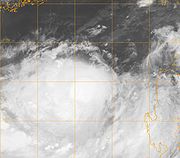
. It is the seventh depression and third typhoon of the season. Forming out of an area of low pressure
on June 14, the storm briefly attained tropical depression status before degenerating. By June 17 the system regenerated in the South China Sea
. Slowly tracking northward, the storm intensified, attaining severe tropical storm status on June 19 and peaking in intensity the following day. On June 21, Linfa made landfall in Fujian Province, China
as a tropical storm before weakening to a tropical depression.
In Taiwan
, outer bands of the storm produced significant amounts of rain over southeastern areas of the island. Along the western coast, rip currents resulted in the drowning of one person. Six hikers also were reported to be missing. In China, torrential rains triggered flooding that destroyed 100 homes, killed one person and left six others missing. In all, seven people were killed by Linfa, with damages in mainland China
estimated at ¥
641 million (US$93.8 million) and agricultural losses in Taiwan reached NT$400 million (US$12.1 million).
(JTWC) began monitoring a persistent area of convection
situated about 140 kilometres (85 mi) southeast of Palau
. Satellite imagery depicted an elongated low-level circulation
with deep convection centered along the southwestern portion of the system. Strong wind shear
, which normally inhibits cyclonic development, provided energy for further convective development around the system. Tracking in a general northwestward direction, the low gradually developed northward outflow
due to a tropical upper tropospheric trough
(TUTT) located north of the disturbance. Following further development, the Japan Meteorological Agency
declared the system as a tropical depression at 0600 UTC
on June 14.
Later on June 14, the JTWC issued a Tropical Cyclone Formation Alert
(TCFA) for the depression. Deep convection consolidated around the center of circulation and convective banding features
developed along the periphery of the system. Several hours later, the TCFA was canceled as the system rapidly degenerated, with convection mostly dissipating and an exposed low. Outflow significantly deteriorated as the system detached itself from the TUTT. By this time, the JMA had ceased advisories on the depression. Two days later, after tracking across Luzon
, the system began to regenerate. Convection redeveloped around the low and outflow was reestablished to the south.
 Early on June 17, the JTWC issued a second TCFA as the system continued to organize. By this time the system was nearly stationary and at 0600 UTC, the JMA declared that the low had developed into a tropical depression. Several hours later, the JTWC designated the system as Tropical Depression 03W while the storm was situated about 705 km (440 mi) south-southwest of Kaohsiung, Taiwan. Little movement took place for the first few days of the storm's existence as weak steering currents were in place over the South China Sea
. Following further development of the depression, the JTWC upgraded it to a tropical storm late on June 17. At 0600 UTC on June 18, the JMA classified the system as a tropical storm and gave it the name Linfa. Limited poleward outflow hindered intensification for the remainder of June 18. By this time, the storm began to increase in forward motion due to a strengthening subtropical
ridge
located east of Taiwan and a mid-latitude trough
to the west.
 Around 1200 UTC the following day, Linfa further intensified into a severe tropical storm. A microwave satellite image of the storm depicted an eye-feature
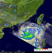
surrounded by deep convection. Interacting with a nearby upper-level low, poleward outflow significantly improved late on June 19, fueling further strengthening. Slowly tracking in a general northward direction, Linfa continued to organize and by June 20, the JTWC upgraded Linfa to a typhoon. A small, ragged eye appeared on visible satellite images by this time and several hours later, the storm reached its peak intensity just below typhoon-status according to the JMA. Maximum sustained winds peaked at 110 km/h (70 mph 10-minute winds) and a barometric pressure of 975 hPa (mbar).
Later on June 20, convection near the center of circulation began to decrease–an indication of weakening–and the eye was no longer visible. Upper-level wind shear rapidly increased to 55 km/h (35 mph), preventing re-intensification of the cyclone. Taking a more northward track than anticipated, Linfa began to interact with land and was downgraded to a tropical storm by the JTWC on June 21. Around 1230 UTC, the storm made landfall in southern Fujian as a tropical storm with winds of 85 km/h (50 mph 10-minute winds). Deep convection rapidly dissipated shortly thereafter due to interaction with land. Several hours later, the JTWC downgraded Linfa to a tropical depression. The following day, the JMA also downgraded Linfa to a tropical depression as the storm moved away from the Chinese coastline. The system later dissipated just offshore; a circulation was no longer evident on satellite imagery.
issued extremely heavy rain warnings, indicating 24-hour rainfall totals in excess of 130 mm (5.1 in) were anticipated, for most of Taiwan. Beaches throughout Taiwan were closed due to rough seas and local officials inspected all public shelters to ensure they were stocked and prepared to provide for evacuees. Later that day, a level 3 emergency was declared for eastern Guangdong Province and southern Fujian Province. The local governments in the provinces enacted their emergency response plans following this declaration.
 On June 21, officials in China closed Xiamen
port and stated that it would resume operations once the storm passed. Later that day 33,000 vessels sought refuge at port. Following the issuance of a land warning, government offices and schools were closed throughout the island. Officials sent 10 million text messages to residents throughout Fujian Province to warn them about the approaching storm. In Hong Kong
, public warning signal number one was raised for nearly 24 hours as Linfa briefly threatened the city on June 20. Officials also evacuated roughly 160,000 people from coastal areas in Fujian. A total of 167 flights to and from Taiwan were canceled or delayed due to the storm.
 On June 21, large swells of up to 5.6 m (18.4 ft) caused a 498-tonne oil tanker, the Colombo Queen, to run aground in southern Taiwan. Rescue crews were unable to reach the ship as it was still in the storm. Although no fuel was reported to have leaked, the ship struck a coral reef
, damaging the coral. Once Linfa passed, rescuers were able to reach the nine crew members on the ship. Officials estimated that it would take over a week to remove all 39000 litres (1,375.7 oz) of fuel from the tanker. In Taiwan, two people were hit by fallen trees and two monks were struck by a wall that collapsed during a ceremony. Rip currents in Taiwan resulted in one death after a boy went into the water unwatched. Six hikers also went missing. Power to all 505 residences of Chiangchun was also lost during the storm. Average amounts of 150 mm (5.9 in) of rain were recorded across southeastern parts of Taiwan on June 21. The highest total was 350 mm (13.8 in) in Taitung
. Further rainfall of 150 mm (5.9 in) fell on June 22, pushing totals over 450 mm (17.7 in) in isolated areas along southeastern areas. In Kinmen County, 50 trees were downed, six billboards were destroyed and two homes lost their roofs. By June 22, power companies reported that 2,834 residents had lost power in Wuqiu Township for several hours. Severe damage was reported in the agricultural sector in Taiwan, leaving NT$400 million (US$12.1 million) in losses.
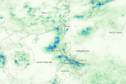
In mainland China, Linfa produced torrential rains, peaking at 488.1 mm (19.2 in) and triggering severe flooding. Heavy rains also impacted Hong Kong
, where more than 100 mm (3.9 in) fell over a three day span. Following a landslide, one person was killed. Flood waters destroyed 100 homes and inundated 10,000 others as well as an estimated 32,000 hectares of farmland in Fujian Province. In Taoyuan Town, a total of 191 mm (7.5 in) of rain fell within one hour, breaking a 200-year-old record in the town. In Meizhou
, Guongdong Province, flash flooding resulted in five additional fatalities after 413.7 mm (16.3 in) of rain fell within a nine-hour span. This rainfall was higher than any recorded amount in the past 100 years in the region. A total of 362 homes were destroyed in the town and infrastructure was severely damaged. Additionally, an estimated 20 million people were affected by the storm. Damages from Linfa in China amounted to ¥
641 million ($93.8 million).
Joint Typhoon Warning Center
The Joint Typhoon Warning Center is a joint United States Navy – United States Air Force task force located at the Naval Maritime Forecast Center in Pearl Harbor, Hawaii...
designation: 03W) was the second named storm to develop in the South China Sea
South China Sea
The South China Sea is a marginal sea that is part of the Pacific Ocean, encompassing an area from the Singapore and Malacca Straits to the Strait of Taiwan of around...
during the 2009 Pacific typhoon season
2009 Pacific typhoon season
The 2009 Pacific typhoon season was the period that tropical cyclones formed in the Western Pacific Ocean. The season ran throughout the year during 2009, with most tropical cyclones forming between May and November. The scope of this article is limited to the Pacific Ocean, north of the equator...
. It is the seventh depression and third typhoon of the season. Forming out of an area of low pressure
Low pressure area
A low-pressure area, or "low", is a region where the atmospheric pressure at sea level is below that of surrounding locations. Low-pressure systems form under areas of wind divergence which occur in upper levels of the troposphere. The formation process of a low-pressure area is known as...
on June 14, the storm briefly attained tropical depression status before degenerating. By June 17 the system regenerated in the South China Sea
South China Sea
The South China Sea is a marginal sea that is part of the Pacific Ocean, encompassing an area from the Singapore and Malacca Straits to the Strait of Taiwan of around...
. Slowly tracking northward, the storm intensified, attaining severe tropical storm status on June 19 and peaking in intensity the following day. On June 21, Linfa made landfall in Fujian Province, China
China
Chinese civilization may refer to:* China for more general discussion of the country.* Chinese culture* Greater China, the transnational community of ethnic Chinese.* History of China* Sinosphere, the area historically affected by Chinese culture...
as a tropical storm before weakening to a tropical depression.
In Taiwan
Taiwan
Taiwan , also known, especially in the past, as Formosa , is the largest island of the same-named island group of East Asia in the western Pacific Ocean and located off the southeastern coast of mainland China. The island forms over 99% of the current territory of the Republic of China following...
, outer bands of the storm produced significant amounts of rain over southeastern areas of the island. Along the western coast, rip currents resulted in the drowning of one person. Six hikers also were reported to be missing. In China, torrential rains triggered flooding that destroyed 100 homes, killed one person and left six others missing. In all, seven people were killed by Linfa, with damages in mainland China
Mainland China
Mainland China, the Chinese mainland or simply the mainland, is a geopolitical term that refers to the area under the jurisdiction of the People's Republic of China . According to the Taipei-based Mainland Affairs Council, the term excludes the PRC Special Administrative Regions of Hong Kong and...
estimated at ¥
Chinese yuan
The yuan is the base unit of a number of modern Chinese currencies. The yuan is the primary unit of account of the Renminbi.A yuán is also known colloquially as a kuài . One yuán is divided into 10 jiǎo or colloquially máo...
641 million (US$93.8 million) and agricultural losses in Taiwan reached NT$400 million (US$12.1 million).
Meteorological history
On June 10, the Joint Typhoon Warning CenterJoint Typhoon Warning Center
The Joint Typhoon Warning Center is a joint United States Navy – United States Air Force task force located at the Naval Maritime Forecast Center in Pearl Harbor, Hawaii...
(JTWC) began monitoring a persistent area of convection
Atmospheric convection
Atmospheric convection is the result of a parcel-environment instability, or temperature difference, layer in the atmosphere. Different lapse rates within dry and moist air lead to instability. Mixing of air during the day which expands the height of the planetary boundary layer leads to...
situated about 140 kilometres (85 mi) southeast of Palau
Palau
Palau , officially the Republic of Palau , is an island nation in the Pacific Ocean, east of the Philippines and south of Tokyo. In 1978, after three decades as being part of the United Nations trusteeship, Palau chose independence instead of becoming part of the Federated States of Micronesia, a...
. Satellite imagery depicted an elongated low-level circulation
Eye (cyclone)
The eye is a region of mostly calm weather found at the center of strong tropical cyclones. The eye of a storm is a roughly circular area and typically 30–65 km in diameter. It is surrounded by the eyewall, a ring of towering thunderstorms where the second most severe weather of a cyclone...
with deep convection centered along the southwestern portion of the system. Strong wind shear
Wind shear
Wind shear, sometimes referred to as windshear or wind gradient, is a difference in wind speed and direction over a relatively short distance in the atmosphere...
, which normally inhibits cyclonic development, provided energy for further convective development around the system. Tracking in a general northwestward direction, the low gradually developed northward outflow
Outflow (meteorology)
Outflow, in meteorology, is air that flows outwards from a storm system. It is associated with ridging, or anticyclonic flow. In the low levels of the troposphere, outflow radiates from thunderstorms in the form of a wedge of rain-cooled air, which is visible as a thin rope-like cloud on weather...
due to a tropical upper tropospheric trough
Tropical Upper Tropospheric Trough
A tropical upper tropospheric trough , also known as the mid-oceanic trough, is a trough situated in upper-level tropics. Its formation is usually caused by the intrusion of energy and wind from the mid-latitudes into the tropics. It can also develop from the inverted trough adjacent to an upper...
(TUTT) located north of the disturbance. Following further development, the Japan Meteorological Agency
Japan Meteorological Agency
The or JMA, is the Japanese government's weather service. Charged with gathering and reporting weather data and forecasts in Japan, it is a semi-autonomous part of the Ministry of Land, Infrastructure and Transport...
declared the system as a tropical depression at 0600 UTC
Coordinated Universal Time
Coordinated Universal Time is the primary time standard by which the world regulates clocks and time. It is one of several closely related successors to Greenwich Mean Time. Computer servers, online services and other entities that rely on having a universally accepted time use UTC for that purpose...
on June 14.
Later on June 14, the JTWC issued a Tropical Cyclone Formation Alert
Tropical Cyclone Formation Alert
A Tropical Cyclone Formation Alert is a bulletin released by the U.S. Navy-operated Joint Typhoon Warning Center in Honolulu, Hawaii or the Naval Maritime Forecast Center in Norfolk, Virginia, warning of the possibility of a tropical cyclone forming from a tropical disturbance that has been...
(TCFA) for the depression. Deep convection consolidated around the center of circulation and convective banding features
Rainband
A rainband is a cloud and precipitation structure associated with an area of rainfall which is significantly elongated. Rainbands can be stratiform or convective, and are generated by differences in temperature. When noted on weather radar imagery, this precipitation elongation is referred to as...
developed along the periphery of the system. Several hours later, the TCFA was canceled as the system rapidly degenerated, with convection mostly dissipating and an exposed low. Outflow significantly deteriorated as the system detached itself from the TUTT. By this time, the JMA had ceased advisories on the depression. Two days later, after tracking across Luzon
Luzon
Luzon is the largest island in the Philippines. It is located in the northernmost region of the archipelago, and is also the name for one of the three primary island groups in the country centered on the Island of Luzon...
, the system began to regenerate. Convection redeveloped around the low and outflow was reestablished to the south.
South China Sea
The South China Sea is a marginal sea that is part of the Pacific Ocean, encompassing an area from the Singapore and Malacca Straits to the Strait of Taiwan of around...
. Following further development of the depression, the JTWC upgraded it to a tropical storm late on June 17. At 0600 UTC on June 18, the JMA classified the system as a tropical storm and gave it the name Linfa. Limited poleward outflow hindered intensification for the remainder of June 18. By this time, the storm began to increase in forward motion due to a strengthening subtropical
Subtropical cyclone
A subtropical cyclone is a weather system that has some characteristics of a tropical and an extratropical cyclone. As early as the 1950s, meteorologists were unclear whether they should be characterized as tropical or extratropical cyclones. They were officially recognized by the National...
ridge
Ridge (meteorology)
A ridge is an elongated region of relatively high atmospheric pressure, the opposite of a trough....
located east of Taiwan and a mid-latitude trough
Trough (meteorology)
A trough is an elongated region of relatively low atmospheric pressure, often associated with fronts.Unlike fronts, there is not a universal symbol for a trough on a weather chart. The weather charts in some countries or regions mark troughs by a line. In the United States, a trough may be marked...
to the west.
Eye (cyclone)
The eye is a region of mostly calm weather found at the center of strong tropical cyclones. The eye of a storm is a roughly circular area and typically 30–65 km in diameter. It is surrounded by the eyewall, a ring of towering thunderstorms where the second most severe weather of a cyclone...
surrounded by deep convection. Interacting with a nearby upper-level low, poleward outflow significantly improved late on June 19, fueling further strengthening. Slowly tracking in a general northward direction, Linfa continued to organize and by June 20, the JTWC upgraded Linfa to a typhoon. A small, ragged eye appeared on visible satellite images by this time and several hours later, the storm reached its peak intensity just below typhoon-status according to the JMA. Maximum sustained winds peaked at 110 km/h (70 mph 10-minute winds) and a barometric pressure of 975 hPa (mbar).
Later on June 20, convection near the center of circulation began to decrease–an indication of weakening–and the eye was no longer visible. Upper-level wind shear rapidly increased to 55 km/h (35 mph), preventing re-intensification of the cyclone. Taking a more northward track than anticipated, Linfa began to interact with land and was downgraded to a tropical storm by the JTWC on June 21. Around 1230 UTC, the storm made landfall in southern Fujian as a tropical storm with winds of 85 km/h (50 mph 10-minute winds). Deep convection rapidly dissipated shortly thereafter due to interaction with land. Several hours later, the JTWC downgraded Linfa to a tropical depression. The following day, the JMA also downgraded Linfa to a tropical depression as the storm moved away from the Chinese coastline. The system later dissipated just offshore; a circulation was no longer evident on satellite imagery.
Preparations and impact
Although Linfa was not forecast to directly impact the Philippines, the outer effects of the storm were anticipated to produce increased rainfall and large swells along western facing coastlines. By June 20, the Central Weather BureauCentral Weather Bureau
The Central Weather Bureau is the government meteorological research and forecasting institution of the Republic of China . In addition to meteorology, the Central Weather Bureau also makes astronomical observations, reports on sea conditions, and conducts research into seismology and provides...
issued extremely heavy rain warnings, indicating 24-hour rainfall totals in excess of 130 mm (5.1 in) were anticipated, for most of Taiwan. Beaches throughout Taiwan were closed due to rough seas and local officials inspected all public shelters to ensure they were stocked and prepared to provide for evacuees. Later that day, a level 3 emergency was declared for eastern Guangdong Province and southern Fujian Province. The local governments in the provinces enacted their emergency response plans following this declaration.
Xiamen
Xiamen , also known as Amoy , is a major city on the southeast coast of the People's Republic of China. It is administered as a sub-provincial city of Fujian province with an area of and population of 3.53 million...
port and stated that it would resume operations once the storm passed. Later that day 33,000 vessels sought refuge at port. Following the issuance of a land warning, government offices and schools were closed throughout the island. Officials sent 10 million text messages to residents throughout Fujian Province to warn them about the approaching storm. In Hong Kong
Hong Kong
Hong Kong is one of two Special Administrative Regions of the People's Republic of China , the other being Macau. A city-state situated on China's south coast and enclosed by the Pearl River Delta and South China Sea, it is renowned for its expansive skyline and deep natural harbour...
, public warning signal number one was raised for nearly 24 hours as Linfa briefly threatened the city on June 20. Officials also evacuated roughly 160,000 people from coastal areas in Fujian. A total of 167 flights to and from Taiwan were canceled or delayed due to the storm.
Coral reef
Coral reefs are underwater structures made from calcium carbonate secreted by corals. Coral reefs are colonies of tiny living animals found in marine waters that contain few nutrients. Most coral reefs are built from stony corals, which in turn consist of polyps that cluster in groups. The polyps...
, damaging the coral. Once Linfa passed, rescuers were able to reach the nine crew members on the ship. Officials estimated that it would take over a week to remove all 39000 litres (1,375.7 oz) of fuel from the tanker. In Taiwan, two people were hit by fallen trees and two monks were struck by a wall that collapsed during a ceremony. Rip currents in Taiwan resulted in one death after a boy went into the water unwatched. Six hikers also went missing. Power to all 505 residences of Chiangchun was also lost during the storm. Average amounts of 150 mm (5.9 in) of rain were recorded across southeastern parts of Taiwan on June 21. The highest total was 350 mm (13.8 in) in Taitung
Taitung City
Taitung City is the county seat of Taitung County, Taiwan. It lies on the southeast coast of Taiwan facing the Pacific Ocean.The city is served by Taitung Airport. Taitung is a gateway to Green Island and Orchid Island, both of which are very popular among Taiwanese tourists.-History:Taitung...
. Further rainfall of 150 mm (5.9 in) fell on June 22, pushing totals over 450 mm (17.7 in) in isolated areas along southeastern areas. In Kinmen County, 50 trees were downed, six billboards were destroyed and two homes lost their roofs. By June 22, power companies reported that 2,834 residents had lost power in Wuqiu Township for several hours. Severe damage was reported in the agricultural sector in Taiwan, leaving NT$400 million (US$12.1 million) in losses.
In mainland China, Linfa produced torrential rains, peaking at 488.1 mm (19.2 in) and triggering severe flooding. Heavy rains also impacted Hong Kong
Hong Kong
Hong Kong is one of two Special Administrative Regions of the People's Republic of China , the other being Macau. A city-state situated on China's south coast and enclosed by the Pearl River Delta and South China Sea, it is renowned for its expansive skyline and deep natural harbour...
, where more than 100 mm (3.9 in) fell over a three day span. Following a landslide, one person was killed. Flood waters destroyed 100 homes and inundated 10,000 others as well as an estimated 32,000 hectares of farmland in Fujian Province. In Taoyuan Town, a total of 191 mm (7.5 in) of rain fell within one hour, breaking a 200-year-old record in the town. In Meizhou
Meizhou
-Administration:The municipal government, Intermediate Court and CPC and PSB bureaux are housed in the district of Jiangnan , on the right bank of Meijiang River.A second district of Meizhou is Jiangbei , on the left bank...
, Guongdong Province, flash flooding resulted in five additional fatalities after 413.7 mm (16.3 in) of rain fell within a nine-hour span. This rainfall was higher than any recorded amount in the past 100 years in the region. A total of 362 homes were destroyed in the town and infrastructure was severely damaged. Additionally, an estimated 20 million people were affected by the storm. Damages from Linfa in China amounted to ¥
Chinese yuan
The yuan is the base unit of a number of modern Chinese currencies. The yuan is the primary unit of account of the Renminbi.A yuán is also known colloquially as a kuài . One yuán is divided into 10 jiǎo or colloquially máo...
641 million ($93.8 million).
See also
- 2009 Pacific typhoon season2009 Pacific typhoon seasonThe 2009 Pacific typhoon season was the period that tropical cyclones formed in the Western Pacific Ocean. The season ran throughout the year during 2009, with most tropical cyclones forming between May and November. The scope of this article is limited to the Pacific Ocean, north of the equator...
- Typhoons in the PhilippinesTyphoons in the PhilippinesTyphoons in the Philippines refer in general to tropical cyclones that enter the Philippine area of responsibility and affect the Philippines. Locally they are called bagyo...