
.gif)
Tropical Storm Edouard (2008)
Encyclopedia
Tropical Storm Edouard was a tropical storm
that organized in the Gulf of Mexico
. A shear line stalled in the northeastern Gulf of Mexico
in early August as troughing aloft dug into the northeast Gulf of Mexico. This energy aloft help to organize a surface low along the shear line early on August 2, which slowly organized over the following day. It strengthened into Tropical Depression Five before gaining intensity and being named Tropical Storm Edouard on August 3, the fifth named storm of the 2008 Atlantic hurricane season
. The tropical storm moved westward to the south of the central Gulf coast on August 4. It made landfall on August 5 on the upper Texas
coast about 40 miles southwest of Port Arthur
and moved west-northwest into the interior of Texas. Edouard weakened quickly over land and was downgraded to a tropical depression late on August 5. The depression turned to the northwest, dropping heavy rains on central Texas on August 6. Damage after Edouard was fairly minor, totaling to $250,000.
entered the northern Gulf of Mexico
, with a low pressure area
developing near Apalachicola, Florida
. The system maintained scattered deep convection
across offshore waters and environmental conditions favored development
. The system tracked generally west-southwestward, due to its position south of a subtropical ridge
extending from Texas
through Florida
. In the afternoon of August 3, a Hurricane Hunters
flight into the system confirmed the development of a reasonable well-defined center of circulation, slightly exposed from a disorganized area of thunderstorms; based on its organization, the National Hurricane Center
(NHC) initiated advisories on Tropical Depression Five about 85 miles (136.8 km) south of the mouth of the Mississippi River
.
Initially, the depression was located in an area of northerly wind shear
and dry air, and as a result it was forecast to slowly intensify. However, Hurricane Hunter data indicated flight level winds of 65 miles per hour (104.6 km/h), and the NHC upgraded it to Tropical Storm Edouard late on August 3. By early on August 4, convection briefly decreased around the center, before a pre-dawn convective flare up enveloped its east side, nearly surrounding the center by afternoon as westerly vertical wind shear
decreased. Later that night, organization continued, and Edouard strengthened to a strong tropical storm with maximum sustained wind
s of 65 miles per hour (104.6 km/h). On the morning of August 5, Edouard made landfall in southern Gilchrist, Texas
and weakened as it moved farther to the west-northwest. The storm was downgraded to a tropical depression late on August 5, turning more to the northwest into central Texas as it continued to weaken. Late on August 6, the depression dissipated over central Texas.
and Texas
coasts were activated. Texas Governor Rick Perry
issued a disaster declaration for 17 Texas counties that could be in the path of Tropical Storm Edouard. Perry activated up to 1,200 National Guard troops, a 70 member rescue team, six helicopters and an incident management team that brings food and water to affected areas. Under the order, about 200 buses are available in San Antonio
and Houston
to help in evacuations. Louisiana Governor Bobby Jindal
declared a statewide emergency. In Cameron Parish, Louisiana
the Office of Emergency Preparedness ordered a mandatory evacuation, where Sheriff's deputies also erected roadblocks. In the Gulf of Mexico
, Shell Oil evacuated about 40 workers from drilling operations. BP
and Chevron
also evacuated workers from platforms in the western and central Gulf, though did not predict substantial effects on production.
and Alabama
led to the deaths of five people, three of which occurred in Panama City, Florida
. In Louisiana
, rainfall reached 3.81 inches (96.8 mm) at Hackberry
. In other portions of the state, 1 to 3 in (25.4 to 76.2 mm) of precipitation fell. Along the coast, storm surge
generally ran 4 to 5 ft (1.2 to 1.5 m) above normal, although a slightly higher tide was reported near Intracoastal City
. The lowest barometric pressure associated with Edouard in the state was 1007.8 mb. The strongest winds were primarily confined to Cameron
, Vermilion
, and Calcasieu
Parishes, where gusts exceeded 40 miles per hour (65 km/h). At Lake Charles
, a gust to 62 miles per hour (99.8 km/h) was recorded. Due to the storm surge, part of Louisiana Highway 82
was closed between Holly Beach
and Johnson Bayou. Minor flooding from the surge traveled up the Calcasieu River
to Lake Charles
; water flooded a local yacht club. Low-lying areas of Intracoastal City were flooded, disrupting marine industries. Damage to trees and powerlines resulted in over 2,000 power outages, and the roofs of several mobile homes were damaged by the high winds. A man fell overboard from a shrimping boat in rough seas from Edouard near the mouth of the Mississippi River
.
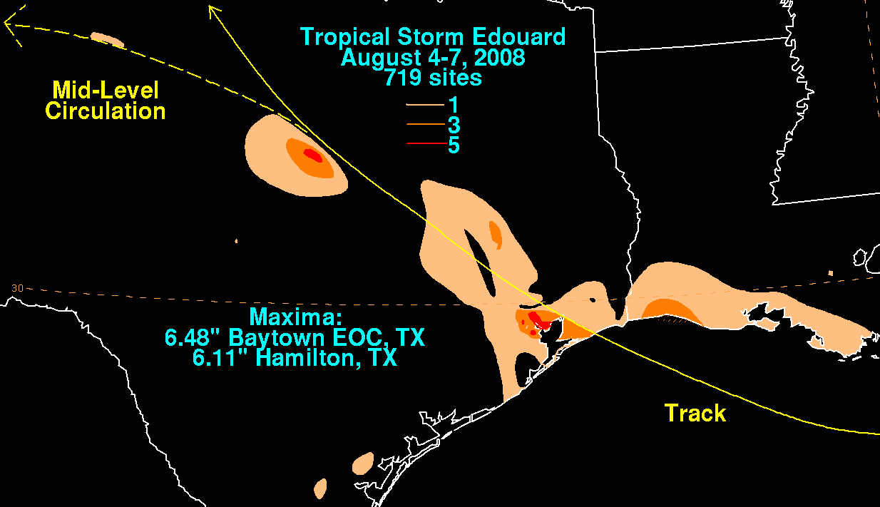 Rainfall from Edouard peaked at 6.48 inches (164.6 mm) at Baytown, Texas
, near Houston
. In central Texas, a burst of thunderstorm activity near the storm's center produced 6.11 inches (155.2 mm) of rain near Hamilton, Texas
; as a result, part of Texas State Highway 36 was closed due to flooding. Elsewhere, 3 to 5 in (76.2 to 127 mm) of precipitation was reported. The heavy rainfall was expected to help relieve persistent drought conditions in some locations. Winds gusted to over 50 miles per hour (80.5 km/h), peaking at over 70 miles per hour (112.7 km/h). At Texas Point, Edouard generated a wind gust of 71 miles per hour (114.3 km/h). The lowest barometric pressure of 996.6 mb occurred at Sea Rim State Park
. Storm surge ranged between 2 and 5 feet (0.60–1.5 m) along the coast. In addition, high surf battered the shore.
Due to the high winds, widespread power outages were reported in Jefferson County. Throughout the county, the winds brought down trees and powerlines, and damaged hundreds of homes. At the storm's peak, at least 37,000 customers in Southeastern Texas were without power. Minor storm surge flooding along portions of the Bolivar Peninsula caused $95,000 (2008 USD) in damage, and forced the closure of Interstate 10
in Chambers County. Numerous structures were flooded with over 6 inches (152.4 mm) of water, reaching 18 inches (457.2 mm) in localized areas. Despite the effects, damage was primarily light.
Tropical cyclone
A tropical cyclone is a storm system characterized by a large low-pressure center and numerous thunderstorms that produce strong winds and heavy rain. Tropical cyclones strengthen when water evaporated from the ocean is released as the saturated air rises, resulting in condensation of water vapor...
that organized in the Gulf of Mexico
Gulf of Mexico
The Gulf of Mexico is a partially landlocked ocean basin largely surrounded by the North American continent and the island of Cuba. It is bounded on the northeast, north and northwest by the Gulf Coast of the United States, on the southwest and south by Mexico, and on the southeast by Cuba. In...
. A shear line stalled in the northeastern Gulf of Mexico
Gulf of Mexico
The Gulf of Mexico is a partially landlocked ocean basin largely surrounded by the North American continent and the island of Cuba. It is bounded on the northeast, north and northwest by the Gulf Coast of the United States, on the southwest and south by Mexico, and on the southeast by Cuba. In...
in early August as troughing aloft dug into the northeast Gulf of Mexico. This energy aloft help to organize a surface low along the shear line early on August 2, which slowly organized over the following day. It strengthened into Tropical Depression Five before gaining intensity and being named Tropical Storm Edouard on August 3, the fifth named storm of the 2008 Atlantic hurricane season
2008 Atlantic hurricane season
The 2008 Atlantic hurricane season was a very active hurricane season with sixteen named storms formed, including eight that became hurricanes and five that became major hurricanes. The season officially started on June 1 and ended on November 30. These dates conventionally delimit the period of...
. The tropical storm moved westward to the south of the central Gulf coast on August 4. It made landfall on August 5 on the upper Texas
Texas
Texas is the second largest U.S. state by both area and population, and the largest state by area in the contiguous United States.The name, based on the Caddo word "Tejas" meaning "friends" or "allies", was applied by the Spanish to the Caddo themselves and to the region of their settlement in...
coast about 40 miles southwest of Port Arthur
Port Arthur, Texas
-Demographics:As of the 2000 census, there were 57,755 people, 21,839 households, and 14,675 families residing in the city. The population density was 696.5 people per square mile . There were 24,713 housing units at an average density of 298.0 per square mile...
and moved west-northwest into the interior of Texas. Edouard weakened quickly over land and was downgraded to a tropical depression late on August 5. The depression turned to the northwest, dropping heavy rains on central Texas on August 6. Damage after Edouard was fairly minor, totaling to $250,000.
Meteorological history
On August 2, 2008, a troughTrough (meteorology)
A trough is an elongated region of relatively low atmospheric pressure, often associated with fronts.Unlike fronts, there is not a universal symbol for a trough on a weather chart. The weather charts in some countries or regions mark troughs by a line. In the United States, a trough may be marked...
entered the northern Gulf of Mexico
Gulf of Mexico
The Gulf of Mexico is a partially landlocked ocean basin largely surrounded by the North American continent and the island of Cuba. It is bounded on the northeast, north and northwest by the Gulf Coast of the United States, on the southwest and south by Mexico, and on the southeast by Cuba. In...
, with a low pressure area
Low pressure area
A low-pressure area, or "low", is a region where the atmospheric pressure at sea level is below that of surrounding locations. Low-pressure systems form under areas of wind divergence which occur in upper levels of the troposphere. The formation process of a low-pressure area is known as...
developing near Apalachicola, Florida
Apalachicola, Florida
Apalachicola is a city in Franklin County, Florida, on US 98 about southwest of Tallahassee. The population was 2,334 at the 2000 census. The 2005 census estimated the city's population at 2,340...
. The system maintained scattered deep convection
Convection
Convection is the movement of molecules within fluids and rheids. It cannot take place in solids, since neither bulk current flows nor significant diffusion can take place in solids....
across offshore waters and environmental conditions favored development
Tropical cyclogenesis
Tropical cyclogenesis is the term that describes the development and strengthening of a tropical cyclone in the atmosphere. The mechanisms through which tropical cyclogenesis occurs are distinctly different from those through which mid-latitude cyclogenesis occurs...
. The system tracked generally west-southwestward, due to its position south of a subtropical ridge
Subtropical ridge
The subtropical ridge is a significant belt of high pressure situated around the latitudes of 30°N in the Northern Hemisphere and 30°S in the Southern Hemisphere. It is characterized by mostly calm winds, which acts to reduce air quality under its axis by causing fog overnight, and haze during...
extending from Texas
Texas
Texas is the second largest U.S. state by both area and population, and the largest state by area in the contiguous United States.The name, based on the Caddo word "Tejas" meaning "friends" or "allies", was applied by the Spanish to the Caddo themselves and to the region of their settlement in...
through Florida
Florida
Florida is a state in the southeastern United States, located on the nation's Atlantic and Gulf coasts. It is bordered to the west by the Gulf of Mexico, to the north by Alabama and Georgia and to the east by the Atlantic Ocean. With a population of 18,801,310 as measured by the 2010 census, it...
. In the afternoon of August 3, a Hurricane Hunters
Hurricane Hunters
The Hurricane Hunters are aircraft that fly into tropical cyclones in the North Atlantic Ocean and Northeastern Pacific Ocean for the specific purpose of directly measuring weather data in and around those storms. In the United States, the Air Force, Navy, and NOAA units have all participated in...
flight into the system confirmed the development of a reasonable well-defined center of circulation, slightly exposed from a disorganized area of thunderstorms; based on its organization, the National Hurricane Center
National Hurricane Center
The National Hurricane Center , located at Florida International University in Miami, Florida, is the division of the National Weather Service responsible for tracking and predicting weather systems within the tropics between the Prime Meridian and the 140th meridian west poleward to the 30th...
(NHC) initiated advisories on Tropical Depression Five about 85 miles (136.8 km) south of the mouth of the Mississippi River
Mississippi River
The Mississippi River is the largest river system in North America. Flowing entirely in the United States, this river rises in western Minnesota and meanders slowly southwards for to the Mississippi River Delta at the Gulf of Mexico. With its many tributaries, the Mississippi's watershed drains...
.
Initially, the depression was located in an area of northerly wind shear
Wind shear
Wind shear, sometimes referred to as windshear or wind gradient, is a difference in wind speed and direction over a relatively short distance in the atmosphere...
and dry air, and as a result it was forecast to slowly intensify. However, Hurricane Hunter data indicated flight level winds of 65 miles per hour (104.6 km/h), and the NHC upgraded it to Tropical Storm Edouard late on August 3. By early on August 4, convection briefly decreased around the center, before a pre-dawn convective flare up enveloped its east side, nearly surrounding the center by afternoon as westerly vertical wind shear
Wind shear
Wind shear, sometimes referred to as windshear or wind gradient, is a difference in wind speed and direction over a relatively short distance in the atmosphere...
decreased. Later that night, organization continued, and Edouard strengthened to a strong tropical storm with maximum sustained wind
Maximum sustained wind
The maximum sustained winds associated with a tropical cyclone are a common indicator of the intensity of the storm. Within a mature tropical cyclone, they are found within the eyewall at a distance defined as the radius of maximum wind, or RMW. Unlike gusts, the value of these winds are...
s of 65 miles per hour (104.6 km/h). On the morning of August 5, Edouard made landfall in southern Gilchrist, Texas
Gilchrist, Texas
Gilchrist, Texas is an unincorporated residential community and beachfront resort along State Highway 87, located seventeen miles east of Bolivar Point in the Bolivar Peninsula census-designated place, in Galveston County, Texas, United States....
and weakened as it moved farther to the west-northwest. The storm was downgraded to a tropical depression late on August 5, turning more to the northwest into central Texas as it continued to weaken. Late on August 6, the depression dissipated over central Texas.
Preparations
In preparations for the storm, emergency teams along the LouisianaLouisiana
Louisiana is a state located in the southern region of the United States of America. Its capital is Baton Rouge and largest city is New Orleans. Louisiana is the only state in the U.S. with political subdivisions termed parishes, which are local governments equivalent to counties...
and Texas
Texas
Texas is the second largest U.S. state by both area and population, and the largest state by area in the contiguous United States.The name, based on the Caddo word "Tejas" meaning "friends" or "allies", was applied by the Spanish to the Caddo themselves and to the region of their settlement in...
coasts were activated. Texas Governor Rick Perry
Rick Perry
James Richard "Rick" Perry is the 47th and current Governor of Texas. A Republican, Perry was elected Lieutenant Governor of Texas in 1998 and assumed the governorship in December 2000 when then-governor George W. Bush resigned to become President of the United States. Perry was elected to full...
issued a disaster declaration for 17 Texas counties that could be in the path of Tropical Storm Edouard. Perry activated up to 1,200 National Guard troops, a 70 member rescue team, six helicopters and an incident management team that brings food and water to affected areas. Under the order, about 200 buses are available in San Antonio
San Antonio, Texas
San Antonio is the seventh-largest city in the United States of America and the second-largest city within the state of Texas, with a population of 1.33 million. Located in the American Southwest and the south–central part of Texas, the city serves as the seat of Bexar County. In 2011,...
and Houston
Houston, Texas
Houston is the fourth-largest city in the United States, and the largest city in the state of Texas. According to the 2010 U.S. Census, the city had a population of 2.1 million people within an area of . Houston is the seat of Harris County and the economic center of , which is the ...
to help in evacuations. Louisiana Governor Bobby Jindal
Bobby Jindal
Piyush "Bobby" Jindal is the 55th and current Governor of Louisiana and formerly a member of the United States House of Representatives. He is a member of the Republican Party....
declared a statewide emergency. In Cameron Parish, Louisiana
Cameron Parish, Louisiana
Cameron Parish is the parish with the most land area in the U.S. state of Louisiana. The parish seat is Cameron and as of 2010, the population was 6,839...
the Office of Emergency Preparedness ordered a mandatory evacuation, where Sheriff's deputies also erected roadblocks. In the Gulf of Mexico
Gulf of Mexico
The Gulf of Mexico is a partially landlocked ocean basin largely surrounded by the North American continent and the island of Cuba. It is bounded on the northeast, north and northwest by the Gulf Coast of the United States, on the southwest and south by Mexico, and on the southeast by Cuba. In...
, Shell Oil evacuated about 40 workers from drilling operations. BP
BP
BP p.l.c. is a global oil and gas company headquartered in London, United Kingdom. It is the third-largest energy company and fourth-largest company in the world measured by revenues and one of the six oil and gas "supermajors"...
and Chevron
Chevron Corporation
Chevron Corporation is an American multinational energy corporation headquartered in San Ramon, California, United States and active in more than 180 countries. It is engaged in every aspect of the oil, gas, and geothermal energy industries, including exploration and production; refining,...
also evacuated workers from platforms in the western and central Gulf, though did not predict substantial effects on production.
Impact
Florida, Alabama, and Louisiana
Rip currents in FloridaFlorida
Florida is a state in the southeastern United States, located on the nation's Atlantic and Gulf coasts. It is bordered to the west by the Gulf of Mexico, to the north by Alabama and Georgia and to the east by the Atlantic Ocean. With a population of 18,801,310 as measured by the 2010 census, it...
and Alabama
Alabama
Alabama is a state located in the southeastern region of the United States. It is bordered by Tennessee to the north, Georgia to the east, Florida and the Gulf of Mexico to the south, and Mississippi to the west. Alabama ranks 30th in total land area and ranks second in the size of its inland...
led to the deaths of five people, three of which occurred in Panama City, Florida
Panama City, Florida
-Personal income:The median income for a household in the city was $31,572, and the median income for a family was $40,890. Males had a median income of $30,401 versus $21,431 for females. The per capita income for the city was $17,830...
. In Louisiana
Louisiana
Louisiana is a state located in the southern region of the United States of America. Its capital is Baton Rouge and largest city is New Orleans. Louisiana is the only state in the U.S. with political subdivisions termed parishes, which are local governments equivalent to counties...
, rainfall reached 3.81 inches (96.8 mm) at Hackberry
Hackberry, Louisiana
Hackberry is a census-designated place in Cameron Parish, Louisiana, United States. The population was 1,699 at the 2000 census. It is part of the Lake Charles Metropolitan Statistical Area.-Geography:Hackberry is located at ....
. In other portions of the state, 1 to 3 in (25.4 to 76.2 mm) of precipitation fell. Along the coast, storm surge
Storm surge
A storm surge is an offshore rise of water associated with a low pressure weather system, typically tropical cyclones and strong extratropical cyclones. Storm surges are caused primarily by high winds pushing on the ocean's surface. The wind causes the water to pile up higher than the ordinary sea...
generally ran 4 to 5 ft (1.2 to 1.5 m) above normal, although a slightly higher tide was reported near Intracoastal City
Intracoastal City, Louisiana
Intracoastal City is an unincorporated community in Vermilion Parish, Louisiana, United States. It is situated on the west bank of the Vermilion River at its junction with the Gulf Intracoastal Waterway and has various port facilities and some permanent residents.Intracoastal City is approximately...
. The lowest barometric pressure associated with Edouard in the state was 1007.8 mb. The strongest winds were primarily confined to Cameron
Cameron Parish, Louisiana
Cameron Parish is the parish with the most land area in the U.S. state of Louisiana. The parish seat is Cameron and as of 2010, the population was 6,839...
, Vermilion
Vermilion Parish, Louisiana
Vermilion Parish is a parish located in the U.S. state of Louisiana. The parish seat is Abbeville. As of the 2010 census, the population was 57,999....
, and Calcasieu
Calcasieu Parish, Louisiana
Calcasieu Parish[p] is a parish located in the U.S. state of Louisiana. The parish seat is Lake Charles. As of 2010, the parish population was 192,768...
Parishes, where gusts exceeded 40 miles per hour (65 km/h). At Lake Charles
Lake Charles, Louisiana
Lake Charles is the fifth-largest incorporated city in the U.S. state of Louisiana, located on Lake Charles, Prien Lake, and the Calcasieu River. Located in Calcasieu Parish, a major cultural, industrial, and educational center in the southwest region of the state, and one of the most important in...
, a gust to 62 miles per hour (99.8 km/h) was recorded. Due to the storm surge, part of Louisiana Highway 82
Louisiana Highway 82
Louisiana Highway 82 is a state highway that serves Cameron Parish, Louisiana and Vermillion Parish, Louisiana. It spans and is the primary road in southern Cameron Parish. The area surrounding LA 82 was heavily damaged in Hurricane Rita....
was closed between Holly Beach
Holly Beach, Louisiana
Holly Beach , also known as the "Cajun Riviera" , is a coastal community in unincorporated Cameron Parish, Louisiana, United States.Known for crabbing and a drive on the beach, this small Southwest Louisiana community mainly consisted of beach-front cabins called "camps" which, due to the threat of...
and Johnson Bayou. Minor flooding from the surge traveled up the Calcasieu River
Calcasieu River
The Calcasieu River is a river on the Gulf Coast of southwestern Louisiana, U.S.A.. Approximately long, it drains a largely rural area of forests and bayou country, meandering southward to the Gulf of Mexico. The name "Calcasieu" comes from the Native American Atakapa language katkosh, for...
to Lake Charles
Lake Charles, Louisiana
Lake Charles is the fifth-largest incorporated city in the U.S. state of Louisiana, located on Lake Charles, Prien Lake, and the Calcasieu River. Located in Calcasieu Parish, a major cultural, industrial, and educational center in the southwest region of the state, and one of the most important in...
; water flooded a local yacht club. Low-lying areas of Intracoastal City were flooded, disrupting marine industries. Damage to trees and powerlines resulted in over 2,000 power outages, and the roofs of several mobile homes were damaged by the high winds. A man fell overboard from a shrimping boat in rough seas from Edouard near the mouth of the Mississippi River
Mississippi River
The Mississippi River is the largest river system in North America. Flowing entirely in the United States, this river rises in western Minnesota and meanders slowly southwards for to the Mississippi River Delta at the Gulf of Mexico. With its many tributaries, the Mississippi's watershed drains...
.
Texas
Baytown, Texas
Baytown is a city within Harris County and partially in Chambers County in the Gulf Coast region of the U.S. state of Texas. Located within the Houston–Sugar Land–Baytown metropolitan area, it lies along both State Highway 146 and Interstate 10. As of 2010, Baytown had an population of 71,802...
, near Houston
Houston, Texas
Houston is the fourth-largest city in the United States, and the largest city in the state of Texas. According to the 2010 U.S. Census, the city had a population of 2.1 million people within an area of . Houston is the seat of Harris County and the economic center of , which is the ...
. In central Texas, a burst of thunderstorm activity near the storm's center produced 6.11 inches (155.2 mm) of rain near Hamilton, Texas
Hamilton, Texas
Hamilton is a city in Hamilton County in Central Texas. The population was 3,095 at the 2010 census. It is the county seat of Hamilton County.-Geography:Hamilton is located at ....
; as a result, part of Texas State Highway 36 was closed due to flooding. Elsewhere, 3 to 5 in (76.2 to 127 mm) of precipitation was reported. The heavy rainfall was expected to help relieve persistent drought conditions in some locations. Winds gusted to over 50 miles per hour (80.5 km/h), peaking at over 70 miles per hour (112.7 km/h). At Texas Point, Edouard generated a wind gust of 71 miles per hour (114.3 km/h). The lowest barometric pressure of 996.6 mb occurred at Sea Rim State Park
Sea Rim State Park
Sea Rim State Park is a state park in southeast Texas.The park is located on the Gulf of Mexico in southern Jefferson County, south of Port Arthur and just west of Sabine Pass. The park was closed for several years due to extensive damage from Hurricanes Rita and Ike . The park has recently...
. Storm surge ranged between 2 and 5 feet (0.60–1.5 m) along the coast. In addition, high surf battered the shore.
Due to the high winds, widespread power outages were reported in Jefferson County. Throughout the county, the winds brought down trees and powerlines, and damaged hundreds of homes. At the storm's peak, at least 37,000 customers in Southeastern Texas were without power. Minor storm surge flooding along portions of the Bolivar Peninsula caused $95,000 (2008 USD) in damage, and forced the closure of Interstate 10
Interstate 10
Interstate 10 is the fourth-longest Interstate Highway in the United States, after I-90, I-80, and I-40. It is the southernmost east–west, coast-to-coast Interstate Highway, although I-4 and I-8 are further south. It stretches from the Pacific Ocean at State Route 1 in Santa Monica,...
in Chambers County. Numerous structures were flooded with over 6 inches (152.4 mm) of water, reaching 18 inches (457.2 mm) in localized areas. Despite the effects, damage was primarily light.
See also
- List of Texas hurricanes
- Other storms of the same nameHurricane EdouardThe name Edouard has been used for five tropical cyclones in the Atlantic Ocean.* 1984's Tropical Storm Edouard - rapidly formed and strengthened in the Bay of Campeche, then degenerated just as quickly, causing no damage....
External links
- National Hurricane Center - Edouard 2008 Graphics Archive
- Tropical Cyclone Report for Tropical Storm Edouard