
Tropical Storm Cyprien
Encyclopedia
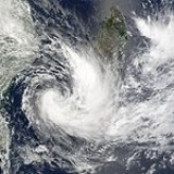
Severe Tropical Storm Cyprien (JTWC
designation: 08S) was a short-lived tropical cyclone
that caused minor damage in Madagascar
. Forming on December 30, Cyprien quickly strengthened in a slightly favorable environment. By January 2, the storm attained its peak intensity with winds of 100 km/h (65 mph) according to Météo-France
and 95 km/h (60 mph) according to the Joint Typhoon Warning Center
. Later that day the storm made landfall in Morombe
, at a weaker intensity, and dissipated early on January 3. Throughout the affected areas, Cyprien destroyed 957 structures, leaving 1.16 billion Malagasy franc
(2002 MGF; ~$181,000 USD) in damages. No fatalities were reported; however two people were listed as missing.
centered around a low pressure area
on December 29, 2001 in the Mozambique Channel
. Located within 95 km (60 mi) of the Mozambique coast. Moderate wind shear
inhibited quick development of the system as it slowly tracked towards the east. The following day, Météo-France
, the Regional Specialized Meteorological Center
, designated the system as a tropical disturbance. Over the next two days, convection became increasingly organized, with banding features developing by December 31. Around 0900 UTC, the Joint Typhoon Warning Center
issued a Tropical Cyclone Formation Alert
for the disturbance. Decreasing wind shear and moderate outflow
would allow the system to intensify into a tropical storm.
On January 1, 2002, Météo-France upgraded the disturbance to a tropical depression as maximum sustained wind
s reached 55 km/h (35 mph 10-minute winds). By this time, the JTWC classified the depression as a tropical storm, designating it as Tropical Cyclone 08S. The system rapidly organized shortly after and was further upgraded to a moderate tropical storm by Météo-France at 0600 UTC, at which time it was given the name Cyprien. In response to a mid to upper-level subtropical
high pressure area
, the storm tracked in a general eastward direction at 16 km/h (10 mph). Several hours after being named, the JTWC assessed Cyprien to have reached its peak winds of 95 km/h (60 mph 1-minute winds). QuickSCAT satellite passes indicated areas of 100 km/h (65 mph) winds early on January 2, prompting Météo-France to upgrade Cyprien to a severe tropical storm, with winds peaking at 100 km/h (65 mph 10-minute winds). By this time, the central barometric pressure fell to 980 hPa (mbar).
Later on January 2, the combination of the subtropical ridge to the north, an approaching mid-latitude
trough
and moderate to strong westerlies
caused Severe Tropical Storm Cyprien to turn towards the southwest. Slight weakening took place shortly before the storm made landfall in Morombe
; maximum winds decreased to 50 mph (85 km/h 10-minute winds). Increased wind shear and interaction with land caused the deep convection to become substantially displaced to the east from the center of circulation
. Early on January 3, Cyprien was downgraded to a tropical depression by both agencies; however, some areas were still reporting gale-force winds. Around 0600 UTC, the former tropical storm dissipated over the mountains of Madagascar.
; a total of 900 people in the city were affected by the storm and two people were reportedly missing. Following an assessment of the storm's impact, 180 homes and 16 administrative buildings were found to have been destroyed by Cyprien. Damages in the area amounted to 1.1 billion Malagasy franc
(2002 MGF; $172,507 USD
). North of Morombe, the city of Morondava
also sustained significant damage; roughly 1,000 people were affected and 661 homes were destroyed. Numerous homes were inundated by floodwaters. Officials reported that floodwaters persisted until January 9. Damages in the city amounted to 60 million MGF (2002 MGF; $9,287 USD). In all, damages from the storm amounted to 1.16 billion MGF (2002 MGF; ~$181,000 USD).
Following Cyprien, the Government of Madagascar did not request international assistance in post-storm recovery. By January 10, a cargo plane carrying 65 million MGF (2002 MGF; $10,062 USD) worth of relief supplies was deployed to the affected regions. The supplies, consisting of medical supplies, tents, and one tonne of rice, were given to local authorities to be distributed to the affected population. Sanitary items were also distributed by the government to avoid an outbreak of water-borne diseases such as diarrhea
and cholera
.
Joint Typhoon Warning Center
The Joint Typhoon Warning Center is a joint United States Navy – United States Air Force task force located at the Naval Maritime Forecast Center in Pearl Harbor, Hawaii...
designation: 08S) was a short-lived tropical cyclone
Tropical cyclone
A tropical cyclone is a storm system characterized by a large low-pressure center and numerous thunderstorms that produce strong winds and heavy rain. Tropical cyclones strengthen when water evaporated from the ocean is released as the saturated air rises, resulting in condensation of water vapor...
that caused minor damage in Madagascar
Madagascar
The Republic of Madagascar is an island country located in the Indian Ocean off the southeastern coast of Africa...
. Forming on December 30, Cyprien quickly strengthened in a slightly favorable environment. By January 2, the storm attained its peak intensity with winds of 100 km/h (65 mph) according to Météo-France
Météo-France
Météo-France is the French national meteorological service.The organisation was established by decree in June 1993 and is a department of the Ministry of Transportation. It is headquartered in Paris but many domestic operations have been decentralised to Toulouse...
and 95 km/h (60 mph) according to the Joint Typhoon Warning Center
Joint Typhoon Warning Center
The Joint Typhoon Warning Center is a joint United States Navy – United States Air Force task force located at the Naval Maritime Forecast Center in Pearl Harbor, Hawaii...
. Later that day the storm made landfall in Morombe
Morombe
Morombe is a coastal city in Atsimo-Andrefana Region, Madagascar. It is located at around and can be reached by pirogue from Morondava.- Literatur :...
, at a weaker intensity, and dissipated early on January 3. Throughout the affected areas, Cyprien destroyed 957 structures, leaving 1.16 billion Malagasy franc
Malagasy franc
The franc was the currency of Madagascar until January 1, 2005. It was subdivided into 100 centimes.-History:The first francs to circulate in Madagascar were French francs...
(2002 MGF; ~$181,000 USD) in damages. No fatalities were reported; however two people were listed as missing.
Meteorological history
Severe Tropical Storm Cyprien originated out of an area of disorganized convectionAtmospheric convection
Atmospheric convection is the result of a parcel-environment instability, or temperature difference, layer in the atmosphere. Different lapse rates within dry and moist air lead to instability. Mixing of air during the day which expands the height of the planetary boundary layer leads to...
centered around a low pressure area
Low pressure area
A low-pressure area, or "low", is a region where the atmospheric pressure at sea level is below that of surrounding locations. Low-pressure systems form under areas of wind divergence which occur in upper levels of the troposphere. The formation process of a low-pressure area is known as...
on December 29, 2001 in the Mozambique Channel
Mozambique Channel
The Mozambique Channel is a portion of the Indian Ocean located between the island nation of Madagascar and southeast Africa, primarily the country of Mozambique. It was a World War II clashpoint during the Battle of Madagascar...
. Located within 95 km (60 mi) of the Mozambique coast. Moderate wind shear
Wind shear
Wind shear, sometimes referred to as windshear or wind gradient, is a difference in wind speed and direction over a relatively short distance in the atmosphere...
inhibited quick development of the system as it slowly tracked towards the east. The following day, Météo-France
Météo-France
Météo-France is the French national meteorological service.The organisation was established by decree in June 1993 and is a department of the Ministry of Transportation. It is headquartered in Paris but many domestic operations have been decentralised to Toulouse...
, the Regional Specialized Meteorological Center
Regional Specialized Meteorological Center
A Regional Specialized Meteorological Centre is responsible for the distribution of information, advisories, and warnings regarding the specific program they have a part of, agreed by consensus at the World Meteorological Organization as part of the World Weather Watch.-Tropical...
, designated the system as a tropical disturbance. Over the next two days, convection became increasingly organized, with banding features developing by December 31. Around 0900 UTC, the Joint Typhoon Warning Center
Joint Typhoon Warning Center
The Joint Typhoon Warning Center is a joint United States Navy – United States Air Force task force located at the Naval Maritime Forecast Center in Pearl Harbor, Hawaii...
issued a Tropical Cyclone Formation Alert
Tropical Cyclone Formation Alert
A Tropical Cyclone Formation Alert is a bulletin released by the U.S. Navy-operated Joint Typhoon Warning Center in Honolulu, Hawaii or the Naval Maritime Forecast Center in Norfolk, Virginia, warning of the possibility of a tropical cyclone forming from a tropical disturbance that has been...
for the disturbance. Decreasing wind shear and moderate outflow
Outflow (meteorology)
Outflow, in meteorology, is air that flows outwards from a storm system. It is associated with ridging, or anticyclonic flow. In the low levels of the troposphere, outflow radiates from thunderstorms in the form of a wedge of rain-cooled air, which is visible as a thin rope-like cloud on weather...
would allow the system to intensify into a tropical storm.
On January 1, 2002, Météo-France upgraded the disturbance to a tropical depression as maximum sustained wind
Maximum sustained wind
The maximum sustained winds associated with a tropical cyclone are a common indicator of the intensity of the storm. Within a mature tropical cyclone, they are found within the eyewall at a distance defined as the radius of maximum wind, or RMW. Unlike gusts, the value of these winds are...
s reached 55 km/h (35 mph 10-minute winds). By this time, the JTWC classified the depression as a tropical storm, designating it as Tropical Cyclone 08S. The system rapidly organized shortly after and was further upgraded to a moderate tropical storm by Météo-France at 0600 UTC, at which time it was given the name Cyprien. In response to a mid to upper-level subtropical
Subtropical cyclone
A subtropical cyclone is a weather system that has some characteristics of a tropical and an extratropical cyclone. As early as the 1950s, meteorologists were unclear whether they should be characterized as tropical or extratropical cyclones. They were officially recognized by the National...
high pressure area
High pressure area
A high-pressure area is a region where the atmospheric pressure at the surface of the planet is greater than its surrounding environment. Winds within high-pressure areas flow outward due to the higher density air near their center and friction with land...
, the storm tracked in a general eastward direction at 16 km/h (10 mph). Several hours after being named, the JTWC assessed Cyprien to have reached its peak winds of 95 km/h (60 mph 1-minute winds). QuickSCAT satellite passes indicated areas of 100 km/h (65 mph) winds early on January 2, prompting Météo-France to upgrade Cyprien to a severe tropical storm, with winds peaking at 100 km/h (65 mph 10-minute winds). By this time, the central barometric pressure fell to 980 hPa (mbar).
Later on January 2, the combination of the subtropical ridge to the north, an approaching mid-latitude
Latitude
In geography, the latitude of a location on the Earth is the angular distance of that location south or north of the Equator. The latitude is an angle, and is usually measured in degrees . The equator has a latitude of 0°, the North pole has a latitude of 90° north , and the South pole has a...
trough
Trough (meteorology)
A trough is an elongated region of relatively low atmospheric pressure, often associated with fronts.Unlike fronts, there is not a universal symbol for a trough on a weather chart. The weather charts in some countries or regions mark troughs by a line. In the United States, a trough may be marked...
and moderate to strong westerlies
Westerlies
The Westerlies, anti-trades, or Prevailing Westerlies, are the prevailing winds in the middle latitudes between 30 and 60 degrees latitude, blowing from the high pressure area in the horse latitudes towards the poles. These prevailing winds blow from the west to the east, and steer extratropical...
caused Severe Tropical Storm Cyprien to turn towards the southwest. Slight weakening took place shortly before the storm made landfall in Morombe
Morombe
Morombe is a coastal city in Atsimo-Andrefana Region, Madagascar. It is located at around and can be reached by pirogue from Morondava.- Literatur :...
; maximum winds decreased to 50 mph (85 km/h 10-minute winds). Increased wind shear and interaction with land caused the deep convection to become substantially displaced to the east from the center of circulation
Eye (cyclone)
The eye is a region of mostly calm weather found at the center of strong tropical cyclones. The eye of a storm is a roughly circular area and typically 30–65 km in diameter. It is surrounded by the eyewall, a ring of towering thunderstorms where the second most severe weather of a cyclone...
. Early on January 3, Cyprien was downgraded to a tropical depression by both agencies; however, some areas were still reporting gale-force winds. Around 0600 UTC, the former tropical storm dissipated over the mountains of Madagascar.
Impact and aftermath
Due to the low-intensity of the storm, damages in southwestern Madagascar were moderate. Heavy rains also fell throughout the region, peaking at 232 mm (9.1 in). The hardest hit area was the city of MorombeMorombe
Morombe is a coastal city in Atsimo-Andrefana Region, Madagascar. It is located at around and can be reached by pirogue from Morondava.- Literatur :...
; a total of 900 people in the city were affected by the storm and two people were reportedly missing. Following an assessment of the storm's impact, 180 homes and 16 administrative buildings were found to have been destroyed by Cyprien. Damages in the area amounted to 1.1 billion Malagasy franc
Malagasy franc
The franc was the currency of Madagascar until January 1, 2005. It was subdivided into 100 centimes.-History:The first francs to circulate in Madagascar were French francs...
(2002 MGF; $172,507 USD
United States dollar
The United States dollar , also referred to as the American dollar, is the official currency of the United States of America. It is divided into 100 smaller units called cents or pennies....
). North of Morombe, the city of Morondava
Morondava
Morondava is a city located in Menabe Region, of which it is the capital, in Madagascar. It is located in the delta of the Morandava River at .-Communication:...
also sustained significant damage; roughly 1,000 people were affected and 661 homes were destroyed. Numerous homes were inundated by floodwaters. Officials reported that floodwaters persisted until January 9. Damages in the city amounted to 60 million MGF (2002 MGF; $9,287 USD). In all, damages from the storm amounted to 1.16 billion MGF (2002 MGF; ~$181,000 USD).
Following Cyprien, the Government of Madagascar did not request international assistance in post-storm recovery. By January 10, a cargo plane carrying 65 million MGF (2002 MGF; $10,062 USD) worth of relief supplies was deployed to the affected regions. The supplies, consisting of medical supplies, tents, and one tonne of rice, were given to local authorities to be distributed to the affected population. Sanitary items were also distributed by the government to avoid an outbreak of water-borne diseases such as diarrhea
Diarrhea
Diarrhea , also spelled diarrhoea, is the condition of having three or more loose or liquid bowel movements per day. It is a common cause of death in developing countries and the second most common cause of infant deaths worldwide. The loss of fluids through diarrhea can cause dehydration and...
and cholera
Cholera
Cholera is an infection of the small intestine that is caused by the bacterium Vibrio cholerae. The main symptoms are profuse watery diarrhea and vomiting. Transmission occurs primarily by drinking or eating water or food that has been contaminated by the diarrhea of an infected person or the feces...
.